|
Thangool Airport
Thangool Airport is an airport at 42 Aerodrome Road, Thangool, Shire of Banana, Queensland, Australia. It is also known as Thangool Aerodrome. It is operated by the Banana Shire Council. Airlines and destinations See also * List of airports in Queensland This is a list of airports in the Australian state of Queensland. __TOC__ List of airports The list is sorted by the name of the community served, click the sort buttons in the table header to switch listing order. Airports named in bold ar ... References Airports in Queensland Shire of Banana Buildings and structures in Central Queensland {{Queensland-airport-stub ... [...More Info...] [...Related Items...] OR: [Wikipedia] [Google] [Baidu] |
Shire Of Banana
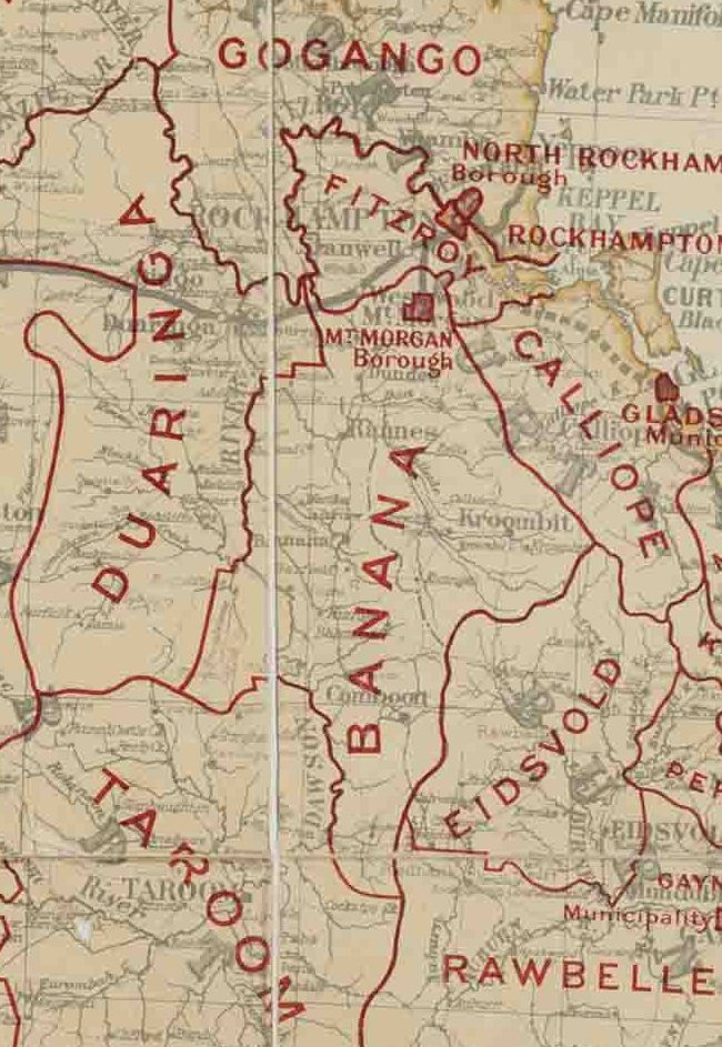
The Shire of Banana is a local government area located in the Capricorn region of Queensland, Australia, inland from the regional city of Gladstone. The shire was named after the first township in the region (Banana), which in turn was named for the burial site of a huge dun coloured bullock named 'Banana'. The council sits in the town of Biloela, which is the largest town in the Shire. Major industries in the shire include coal mining, beef production, power generation, dryland cropping and irrigation cropping such as lucerne and cotton. History Banana Division was created on 11 November 1879 as one of 74 divisions around Queensland under the ''Divisional Boards Act 1879'' with a population of 2155. The name ''Banana'' does not relate to the fruit, but rather the area was named after a dun-coloured bullock called ''Banana''. On 20 April 1881 part of Banana Division was separated to create Duaringa Division. With the passage of the ''Local Authorities Act 1902'', Bana ... [...More Info...] [...Related Items...] OR: [Wikipedia] [Google] [Baidu] |
Thangool, Queensland
Thangool is a rural town and locality in the Shire of Banana, Queensland, Australia. In the , the locality of Thangool had a population of 741 people. Geography Thangool is north west of the state capital, Brisbane and south of the Shire administrative centre, Biloela. Kariboe is a neighbourhood (). Mount Scoria is a neighbourhood (). Thangool has the following named ranges: * Banana Range () in the south-west of the locality * Dawes Range () in the south-east of the locality Thangool has the following named mountains: * Mount Lookerbie () * Mount Scoria () * Mount Sugarloaf () * Prospect Peak () The former Callide Valley railway line ran through the locality and had the following three now-abandoned railway stations: * Thangool railway station () * Kariboe railway station () * Mount Scoria railway station () The predominant land use is grazing on native vegetation with a small amount of crop growing. History The Thangool area was originally home to the Kangulu ... [...More Info...] [...Related Items...] OR: [Wikipedia] [Google] [Baidu] |
Thangool
Thangool is a rural town and Suburbs and localities (Australia), locality in the Shire of Banana, Queensland, Australia. In the , the locality of Thangool had a population of 741 people. Geography Thangool is north west of the state capital, Brisbane and south of the Shire administrative centre, Biloela, Queensland, Biloela. Kariboe is a neighbourhood (). Mount Scoria is a neighbourhood (). Thangool has the following named ranges: * Banana Range () in the south-west of the locality * Dawes Range () in the south-east of the locality Thangool has the following named mountains: * Mount Lookerbie () * Mount Scoria () * Mount Sugarloaf () * Prospect Peak () The former Callide Valley railway line ran through the locality and had the following three now-abandoned railway stations: * Thangool railway station () * Kariboe railway station () * Mount Scoria railway station () The predominant land use is Pastoralism, grazing on native vegetation with a small amount of crop gro ... [...More Info...] [...Related Items...] OR: [Wikipedia] [Google] [Baidu] |
Queensland
) , nickname = Sunshine State , image_map = Queensland in Australia.svg , map_caption = Location of Queensland in Australia , subdivision_type = Country , subdivision_name = Australia , established_title = Before federation , established_date = Colony of Queensland , established_title2 = Separation from New South Wales , established_date2 = 6 June 1859 , established_title3 = Federation , established_date3 = 1 January 1901 , named_for = Queen Victoria , demonym = , capital = Brisbane , largest_city = capital , coordinates = , admin_center_type = Administration , admin_center = 77 local government areas , leader_title1 = Monarch , leader_name1 = Charles III , leader_title2 = Governor , leader_name2 = Jeannette Young , leader_title3 = Premier , leader_name3 = Annastacia Palaszczuk ( ALP) , legislature = Parliament of Queensland , judiciary = Supreme Court of Queensland , national_representation = Parliament of Australia , national_representation_type ... [...More Info...] [...Related Items...] OR: [Wikipedia] [Google] [Baidu] |
Aeronautical Information Publication
In aviation, an Aeronautical Information Publication (or AIP) is defined by the International Civil Aviation Organization as a publication issued by or with the authority of a state and containing aeronautical information of a lasting character essential to air navigation. It is designed to be a manual containing thorough details of regulations, procedures and other information pertinent to flying aircraft in the particular country to which it relates. It is usually issued by or on behalf of the respective civil aviation administration. Overview The structure and contents of AIPs are standardized by international agreement through ICAO. AIPs normally have three parts – GEN (general), ENR (en route) and AD (aerodromes). The document contains many charts; most of these are in the AD section where details and charts of all public aerodromes are published. AIPs are kept up-to-date by regular revision on a fixed cycle. For operationally significant changes in information, the ... [...More Info...] [...Related Items...] OR: [Wikipedia] [Google] [Baidu] |
Thangool Airport Terminal, 2014
Thangool is a rural town and locality in the Shire of Banana, Queensland, Australia. In the , the locality of Thangool had a population of 741 people. Geography Thangool is north west of the state capital, Brisbane and south of the Shire administrative centre, Biloela. Kariboe is a neighbourhood (). Mount Scoria is a neighbourhood (). Thangool has the following named ranges: * Banana Range () in the south-west of the locality * Dawes Range () in the south-east of the locality Thangool has the following named mountains: * Mount Lookerbie () * Mount Scoria () * Mount Sugarloaf () * Prospect Peak () The former Callide Valley railway line ran through the locality and had the following three now-abandoned railway stations: * Thangool railway station () * Kariboe railway station () * Mount Scoria railway station () The predominant land use is grazing on native vegetation with a small amount of crop growing. History The Thangool area was originally home to the Kangulu ... [...More Info...] [...Related Items...] OR: [Wikipedia] [Google] [Baidu] |
Link Airways
Vee H Aviation Pty Ltd, operating as Link Airways, formerly known as Fly Corporate, is an Australian regional airline based at Brisbane Airport, Queensland. The airline operates scheduled regional passenger services in Queensland, New South Wales, Victoria, Tasmania and the Australian Capital Territory. Link Airways operates a fleet of Saab 340B Plus and Fairchild Metro 23 turboprop aircraft. On 11 August 2020 the company rebranded from Fly Corporate to Link Airways. Overview Link Airways was launched as Fly Corporate in 2016 by Corporate Air, an existing air charter company that has been operating since 1972. The airline bases its aircraft at Brisbane Airport and Canberra Airport, from where it operates to regional destinations across Queensland, New South Wales, Victoria, and Tasmania. In October 2020, Link Airways announced that it would begin scheduled flights between Canberra and Hobart (6 days per week) as well as Canberra and Newcastle (11 times per week). On 2 De ... [...More Info...] [...Related Items...] OR: [Wikipedia] [Google] [Baidu] |
Brisbane Airport
Brisbane Airport is the primary international airport serving Brisbane and South East Queensland. The airport services 31 airlines flying to 50 domestic and 29 international destinations, in total amounting to more than 22.7 million passengers who travelled through the airport in 2016. In 2016, an OAG report named Brisbane airport as the fifth-best performing large-sized airport in the world for on-time performance with 86.71% of arrivals and departures occurring within 15 minutes of their scheduled times, slipping from 88.31% the year before. Brisbane Airport is a major hub for both Virgin Australia and Qantas, and a secondary hub for Qantas' low cost subsidiary Jetstar. Brisbane has the third highest number of domestic connections in Australia following Sydney and Melbourne. It is also home to Qantas' A330 and B737 heavy maintenance facilities. Virgin Australia has a smaller maintenance facility at the airport, where line-maintenance on the airline's 737 fleet is performed ... [...More Info...] [...Related Items...] OR: [Wikipedia] [Google] [Baidu] |
List Of Airports In Queensland
This is a list of airports in the Australian state of Queensland. __TOC__ List of airports The list is sorted by the name of the community served, click the sort buttons in the table header to switch listing order. Airports named in bold are Designated International Airports, even if they have limited or no scheduled international services. Defunct airports {, class="wikitable sortable" style="width:auto;" ! width="*" , Community ! width="*" , Airport name ! width="*" , Type ! width="*" , ICAO ! width="*" , IATA ! width="*" , Coordinates , - , Antil Plains, , Antil Plains Aerodrome, , Military, , , , , , , - , Eagle Farm, Brisbane, , Eagle Farm Airport, , Military/Public, , , , , , , - , Charters Towers, , Breddan Aerodrome, , Military, , , , , , , - , Petrie, Brisbane, , Petrie Airfield, , Military, , , , , , , - , Tarampa, , Tarampa Airfield, , Military, , , , , , , - , Townsville, , Aitkenvale ... [...More Info...] [...Related Items...] OR: [Wikipedia] [Google] [Baidu] |
Airports In Queensland
An airport is an aerodrome with extended facilities, mostly for commercial air transport. Airports usually consists of a landing area, which comprises an aerially accessible open space including at least one operationally active surface such as a runway for a plane to take off and to land or a helipad, and often includes adjacent utility buildings such as control towers, hangars and terminals, to maintain and monitor aircraft. Larger airports may have airport aprons, taxiway bridges, air traffic control centres, passenger facilities such as restaurants and lounges, and emergency services. In some countries, the US in particular, airports also typically have one or more fixed-base operators, serving general aviation. Operating airports is extremely complicated, with a complex system of aircraft support services, passenger services, and aircraft control services contained within the operation. Thus airports can be major employers, as well as important hubs for tourism ... [...More Info...] [...Related Items...] OR: [Wikipedia] [Google] [Baidu] |


