|
Terazije
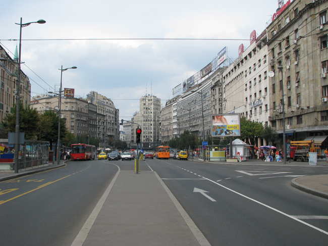
Terazije ( sr-Cyrl, Теразијe) is the central town square and the surrounding neighborhood of Belgrade, Serbia. It is located in the municipality of Stari Grad. Today, Terazije has primarily function of the main transit square, surrounded by the important public buildings, cultural institutions, hotels, public monuments and parks. Though not classically shaped square, Terazije was historically important as the gathering spot and the former business and commercial center of Belgrade. With the Knez Mihailova Street, which extends to the northeast connecting directly Terazije and Belgrade Fortress, the square is one of the oldest and most recognizable ambience units of Belgrade. Due to its historical and cultural importance, Terazije was declared a protected spatial cultural-historical unit in January 2020. Location Despite the fact that many Belgraders consider the Republic Square or Kalemegdan to be the city's centerpiece areas, Terazije is Belgrade's designated cente ... [...More Info...] [...Related Items...] OR: [Wikipedia] [Google] [Baidu] |
Zeleni Venac
Zeleni Venac ( sr-cyr, Зелени венац) or colloquially Zelenjak ( sr-cyr, Зелењак) is an urban neighborhood of Belgrade, the capital of Serbia. It is located in the Belgrade's municipalities of Savski Venac (major part) and Stari Grad. Location Zeleni Venac is located in downtown Belgrade, just few minutes away to the east of Terazije, the designated center of the city, down the Prizrenska or Sremska streets. It borders the neighborhood of Savamala to the south, while the northern border is Brankova Street which separates it from the neighborhoods of Kosančićev Venac and Varoš Kapija in the municipality of Stari Grad. The car tunnel ('' Terazije Tunnel'') under Terazije connects it to Republic Square while underground pedestrian passage connects it to Terazije and Prince Michael Street via Prizrenska and Sremska streets, respectively. Park Luka Ćelović is on the southeast border of the neighborhood. History Antiquity Northern part of modern neighb ... [...More Info...] [...Related Items...] OR: [Wikipedia] [Google] [Baidu] |
Republic Square (Belgrade)
The Republic Square or the Square of the Republic (Serbian: Трг републике / Trg republike) is one of the central town squares and an urban neighborhood of Belgrade, located in the Stari Grad municipality. It is the site of some of Belgrade's most recognizable public buildings, including the National Museum, the National Theatre and the statue of Prince Michael. Location The square is located less than 100 meters away from Terazije, designated center of Belgrade, to which it is connected by the streets of ''Kolarčeva'' (traffic) and '' Knez Mihailova'' (pedestrian zone). Many people erroneously consider Square of the Republic to be the center of the city. Through ''Vasina'' street it is connected to the fortress and park of Kalemegdan to the west and through Sremska street it is connected to the neighborhood of Zeleni Venac and further to Novi Beograd. It also borders the neighborhoods of Stari Grad and Dorćol, to the north. Today, it makes one of the local ... [...More Info...] [...Related Items...] OR: [Wikipedia] [Google] [Baidu] |
Belgrade
Belgrade ( , ;, ; Names of European cities in different languages: B, names in other languages) is the Capital city, capital and List of cities in Serbia, largest city in Serbia. It is located at the confluence of the Sava and Danube rivers and the crossroads of the Pannonian Basin, Pannonian Plain and the Balkan Peninsula. Nearly 1,166,763 million people live within the administrative limits of the City of Belgrade. It is the third largest of all List of cities and towns on Danube river, cities on the Danube river. Belgrade is one of the List of oldest continuously inhabited cities, oldest continuously inhabited cities in Europe and the world. One of the most important prehistoric cultures of Europe, the Vinča culture, evolved within the Belgrade area in the 6th millennium BC. In antiquity, Thracians, Thraco-Dacians inhabited the region and, after 279 BC, Celts settled the city, naming it ''Singidunum, Singidūn''. It was Roman Serbia, conquered by the Romans under the reign ... [...More Info...] [...Related Items...] OR: [Wikipedia] [Google] [Baidu] |
Nikola Pašić Square
The Nikola Pašić Square ( sr, / ) is one of the central town squares and an urban neighborhoods of Belgrade, the capital of Serbia. The square is named after Nikola Pašić who served as mayor of Belgrade, prime minister of Serbia and prime minister of Yugoslavia. Until 1992 the square was named the Square of Marx and Engels ( sr, Трг Маркса и Енгелса, Trg Marksa i Engelsa). Location Located in the municipality of Stari Grad, Nikola Pašić Square lies in downtown Belgrade as the direct extension of Terazije. Named after Nikola Pašić, Serbia's famous early 20th century politician and Prime Minister, it overlooks the monumental building of the House of the National Assembly of the Republic of Serbia and itself extends into urban Belgrade's longest street, Bulevar kralja Aleksandra, while Dečanska Street connects it to the Republic Square. History At the corner of Bulevar Kralja Aleksandra and Dečanska Street, near the former "Topola" '' kafana' ... [...More Info...] [...Related Items...] OR: [Wikipedia] [Google] [Baidu] |
Knez Mihailova Street
Knez Mihailova Street, ( sr, Кнез Михаилова улица, translit=Knez Mihailova ulica, officially: sr, Улица кнеза Михаила, translit=Ulica kneza Mihaila, label=none), is the main pedestrian and shopping zone in Belgrade, and is protected by law as one of the oldest and most valuable landmarks of the city. Named after Mihailo Obrenović III, Prince of Serbia, it features a number of buildings and mansions built during the late 1870s. One kilometer long Knez Mihailova Street was protected in 1964 as the spatial cultural-historical unit, the first cultural monument of that type in Belgrade. In 1979 it was elevated to the Spatial Cultural-Historical Units of Great Importance, and as such is protected by the Republic of Serbia. History Roman period The street follows the central grid layout of the Roman city of Singidunum, as one of the main access roads to the city corresponds to the modern street today. Ihe main axis of urban development was along ... [...More Info...] [...Related Items...] OR: [Wikipedia] [Google] [Baidu] |
Slavija (Belgrade)
Slavija Square ( sr-cyr, Трг Славија, Trg Slavija) is a major commercial junction between the intersections of Kralja Milana, Beogradska, Makenzijeva, Svetosavska, Bulevar oslobođenja, Deligradska and Nemanjina streets in Belgrade. The square was previously named Dimitrije Tucović Square after the prominent Serbian socialist. Location Slavija is located less than south of Terazije (downtown Belgrade), at an altitude of . The square itself belongs entirely to the municipality of Vračar, though the municipality of Savski Venac begins immediately to the west. The Slavija neighborhood which surrounds the square borders the neighborhoods of Cvetni Trg in the north, Grantovac and Krunski Venac in the north and north-east, and Englezovac and Savinac in the south-east, all in Vračar. The Manjež park is to the north, while West Vračar is to the west, both in Savski Venac. History 19th century Until the 1880s, the area around Slavija was a large pool on the easte ... [...More Info...] [...Related Items...] OR: [Wikipedia] [Google] [Baidu] |
Stari Grad, Belgrade
Stari Grad ( sr-Cyrl, Стари Град, ) is a municipality of the city of Belgrade. It encompasses some of the oldest sections of urban Belgrade, thus the name (‘’stari grad’’, Serbian for “old city”). Stari Grad is one of the three municipalities that occupy the very center of Belgrade, together with Savski Venac and Vračar. History Despite some of the oldest sections of Belgrade belong to Stari Grad, the municipality itself is among the latest urban ones formed administratively. It was formed by the merger of the municipality of Skadarlija and part of the municipality of Terazije on January 1, 1957. Geography Stari Grad occupies the ending ridge of Šumadija geological bar .The cliff-like ridge, where the fortress of Kalemegdan is located, overlooks the Great War Island and the confluence of the Sava river into the Danube, and makes one of the most beautiful natural lookouts in Belgrade. With Novi Beograd, it is one of 2 municipalities of Belgrade (out o ... [...More Info...] [...Related Items...] OR: [Wikipedia] [Google] [Baidu] |
Singidunum
Singidunum ( sr, Сингидунум/''Singidunum'') was an ancient city which later evolved into modern Belgrade, the capital of Serbia. The name is of Celtic origin, going back to the time when Celtic tribe Scordisci settled the area in the 3rd century BC, following the Gallic invasion of the Balkans. Later on, the Roman Republic conquered the area in 75 BC and incorporated it into the province of Moesia. It was an important fort of the Danubian Limes and Roman Legio IV Flavia Felix was garrisoned there since 86 AD. Singidunum was the birthplace of the Roman Emperor Jovian. It was sacked by Huns in 441, and by Avars and Slavs in 584. At the beginning of the 7th century, the Singidunum fort was finally destroyed. A large part of Belgrade's downtown belongs to the "Archaeological Site of Singidunum", which was declared a protected zone on 30 June 1964. Celtic period Origin The Scythian and Thracian- Cimmerian tribes traversed through the region in 7th and 6th century ... [...More Info...] [...Related Items...] OR: [Wikipedia] [Google] [Baidu] |
Pioneers Park, Belgrade
Pioneers Park ( sr, Пионирски парк) is a park in Belgrade, the capital of Serbia. Developed from the royal garden, which itself was a successor of a much older garden, it is today one of the central city parks. It has been open for public since 1944. The park has been declared a botanical natural monument. Location The park is located in the municipality of Stari Grad. It is bounded by the streets of Bulevar Kralja Aleksandra on the northeast, Kneza Miloša on the southeast, ''Kralja Milana'' on the west and ''Dragoslava Jovanovićа'' on the north, occupying majority of the area in the block formed by these streets. Being located in downtown Belgrade, it is surrounded by important city buildings and localities: House of the National Assembly of Serbia, Nikola Pašić Square, Dom Sindikata on the north, former royal courts of Stari Dvor and Novi Dvor, Andrićev Venac, Terazije on the west, London on the southwest, Krunski Venac on the south, Tašmajdan on the e ... [...More Info...] [...Related Items...] OR: [Wikipedia] [Google] [Baidu] |
Andrićev Venac
Andrićev Venac ( sr-cyr, Андрићев венац; ) is a street and the surrounding urban neighborhood of Belgrade, the capital of Serbia. It is located in Belgrade's municipality of Stari Grad. As the official seat of the President of Serbia is located in it, it became synonymous for the politics of the president. Location Andrićev Venac is encompassing a corner of the ''Kralja Milana'' and '' Kneza Miloša'', two main streets in downtown Belgrade with the street-promenade of the same name traversing through the small neighborhood. It is some south-east from Terazije, Belgrade's downtown. It extends into the neighborhood of London in the south and south-west, into Terazije in the north-west, Krunski Venac in the east, Pioneers Park in the north-east and the Square of Nikola Pašić in the north. Characteristics Promenade The central area is a pedestrian zone, a short paved promenade which connects Pioneers Park and "Kralja Milana" street. Andrićev Venac ... [...More Info...] [...Related Items...] OR: [Wikipedia] [Google] [Baidu] |
Grčka Kraljica
Grčka Kraljica or Greek Queen ( sr, Грчка краљица) is a former kafana in Belgrade, the capital of Serbia. Built in 1835, the building is located on Knez Mihailova Street, the commercial hub of downtown Belgrade. For decades, it was one of the favorite kafanas in the city, but it was closed in 2007. Location Grčka Kraljica is located at 51 Knez Mihailova street, near the end of the street and close to Kalemegdan Park, in the municipality of Stari Grad. It is situated on the corner of Knez Mihailova and ''Rajićeva'' streets. West of the building, across the ''Rajićeva'', is the Faculty of Fine Arts, part of University of Arts in Belgrade. To the north and northwest, across the Knez Mihailova, are the City Library and the Rajićeva Shopping Mall. History Origin The lot on which the building was constructed was location of one of the three water towers which made city waterworks during the Ottoman period. The Ottomans constructed an aqueduct (''đeriz ... [...More Info...] [...Related Items...] OR: [Wikipedia] [Google] [Baidu] |
Ruski Car Tavern
Ruski Car or Russian Tsar ( sr, Руски цар) is a commercial-residential building and a restaurant in downtown Belgrade, the capital of Serbia. It is located in Knez Mihailova Street, a pedestrian zone and a commercial hub of the city. One of the most luxurious restaurants in the city at the time, it was described as a place where "people come to be seen". The building, finished in 1926, was declared a cultural monument in 1987. Location The building is located on the corner of 7 Knez Mihailova (the official address) and 29 Obilićev Venac Streets. It is situated in the western extension of the Republic Square, across the Cultural Center of Belgrade and in the vicinity of Hotel Majestic, with the National Theater in Belgrade being right across the square. History Origin During the Ottoman period, they constructed an aqueduct (''đeriz''), to conduct water from the springs in the area of Veliki Mokri Lug. In downtown, they built three water towers: one at Terazij ... [...More Info...] [...Related Items...] OR: [Wikipedia] [Google] [Baidu] |


.jpg)


