|
Taldou District
Taldou District ( ar-at, منطقة تلدو, manṭiqat Taldou) is a district of the Homs Governorate in central Syria. Administrative centre is the town of Taldou. The Northwestern Quadrant of the District is within Wadi al-Nasara, an Antiochian Greek Orthodox population region and cultural area. Krak Des Chevaliers, a famous Crusader Castle, is in the northwesternmost edge of the district. The district was formed in 2010 from three sub-districts formerly belonging to Homs District Homs District ( ar-at, منطقة حمص, manṭiqat Ḥimṣ) is a district of the Homs Governorate in central Syria. The administrative centre is the city of Homs. The district was split in 2010, when three sub-districts were separated to for .... At the 2004 census, these sub-districts had a total population of 90,139. Sub-districts The district of Taldou is divided into three sub-districts or nawāḥī (population as of 2004): * Taldou Subdistrict (ناحية تلدو): population 71,503. ... [...More Info...] [...Related Items...] OR: [Wikipedia] [Google] [Baidu] |
Districts Of Syria
The 14 governorates of Syria, or ''muhafazat'' (sing. ''muhafazah''), are divided into 65 districts, or ''manatiq'' (sing. ''mintaqah''), including the city of Damascus. The districts are further divided into 281 subdistricts, or ''nawahi'' (sing. ''nahiya''). Each district bears the same name as its district capital. Districts and subdistricts are administered by officials appointed by the governor, subject to the approval of the minister of the interior. These officials work with elected district councils to attend to assorted local needs, and serve as intermediaries between central government authority and traditional local leaders, such as village chiefs, clan leaders, and councils of elders. List of districts The 65 districts are listed below by governorate (with capital districts in bold text). The city of Damascus functions as a governorate, a district and a subdistrict. Parts of Quneitra Governorate have been under Israeli occupation since 1967 (see Golan Heights). Cen ... [...More Info...] [...Related Items...] OR: [Wikipedia] [Google] [Baidu] |
Administrative Centre
An administrative center is a seat of regional administration or local government, or a county town, or the place where the central administration of a commune is located. In countries with French as administrative language (such as Belgium, Luxembourg, Switzerland and many African countries), a (, plural form , literally 'chief place' or 'main place'), is a town or city that is important from an administrative perspective. Algeria The capital of an Algerian province is called a chef-lieu. The capital of a district, the next largest division, is also called a chef-lieu, whilst the capital of the lowest division, the municipalities, is called agglomération de chef-lieu (chef-lieu agglomeration) and is abbreviated as A.C.L. Belgium The chef-lieu in Belgium is the administrative centre of each of the ten provinces of Belgium. Three of these cities also give their name to their province ( Antwerp, Liège and Namur). France The chef-lieu of a département is known as the ''pr ... [...More Info...] [...Related Items...] OR: [Wikipedia] [Google] [Baidu] |
Al-Qabu, Syria
Al-Qabu ( ar, القبو, also spelled Kabu) is a town in central Syria, administratively part of the Homs Governorate, northwest of Homs. Nearby localities include al-Shinyah to the north, Taldou and Kafr Laha to the northeast, Sharqliyya to the east, al-Mahfurah to the south, Rabah to the southwest and Fahel to the west. According to the Syria Central Bureau of Statistics (CBS), al-Qabu had a population of 4,870 in the 2004 census. References Bibliography * Populated places in Homs District Towns in Syria Alawite communities in Syria {{HomsSY-geo-stub ... [...More Info...] [...Related Items...] OR: [Wikipedia] [Google] [Baidu] |
Kafr Laha
Kafr Laha ( ar, كفرلاها) is a town in the Homs Governorate north of Homs in northern Syria. In 2004 it had a population of 20,041 according to the Central Bureau of Statistics of Syria. Its inhabitants are predominantly Sunni Muslims. It is the largest town in the Houla region. Nearby localities include Tallaf to the northeast, Tell Dahab to the north, Aqrab to the northwest, Qarmas and Maryamin to the west, al-Taybah al-Gharbiyah to the southwest and Taldou to the southeast. History Kafr Laha has been identified as the ancient Aramaean The Arameans ( oar, 𐤀𐤓𐤌𐤉𐤀; arc, 𐡀𐡓𐡌𐡉𐡀; syc, ܐܪ̈ܡܝܐ, Ārāmāyē) were an ancient Semitic-speaking people in the Near East, first recorded in historical sources from the late 12th century BCE. The Aramean ... settlement of Byt'l also known as "Bethel". Kafr Laha has been the site of demonstrations against the Assad government during the ongoing Syrian uprising which began in 2011. Reference ... [...More Info...] [...Related Items...] OR: [Wikipedia] [Google] [Baidu] |
Homs District
Homs District ( ar-at, منطقة حمص, manṭiqat Ḥimṣ) is a district of the Homs Governorate in central Syria. The administrative centre is the city of Homs. The district was split in 2010, when three sub-districts were separated to form the new Taldou District Taldou District ( ar-at, منطقة تلدو, manṭiqat Taldou) is a district of the Homs Governorate in central Syria. Administrative centre is the town of Taldou. The Northwestern Quadrant of the District is within Wadi al-Nasara Wadi al .... At the 2004 census, the remaining sub-districts had a total population of 945,299. Sub-districts The district of Homs is divided into ten sub-districts or nawāḥī (population as of 2004): * Homs Subdistrict (ناحية حمص): population 750,501. * Khirbet Tin Nur Subdistrict (ناحية خربة تين نور): population 52,879. * Ayn al-Niser Subdistrict (ناحية عين النسر): population 30,267. * Furqlus Subdistrict (ناحية الفرقلس) ... [...More Info...] [...Related Items...] OR: [Wikipedia] [Google] [Baidu] |
Krak Des Chevaliers
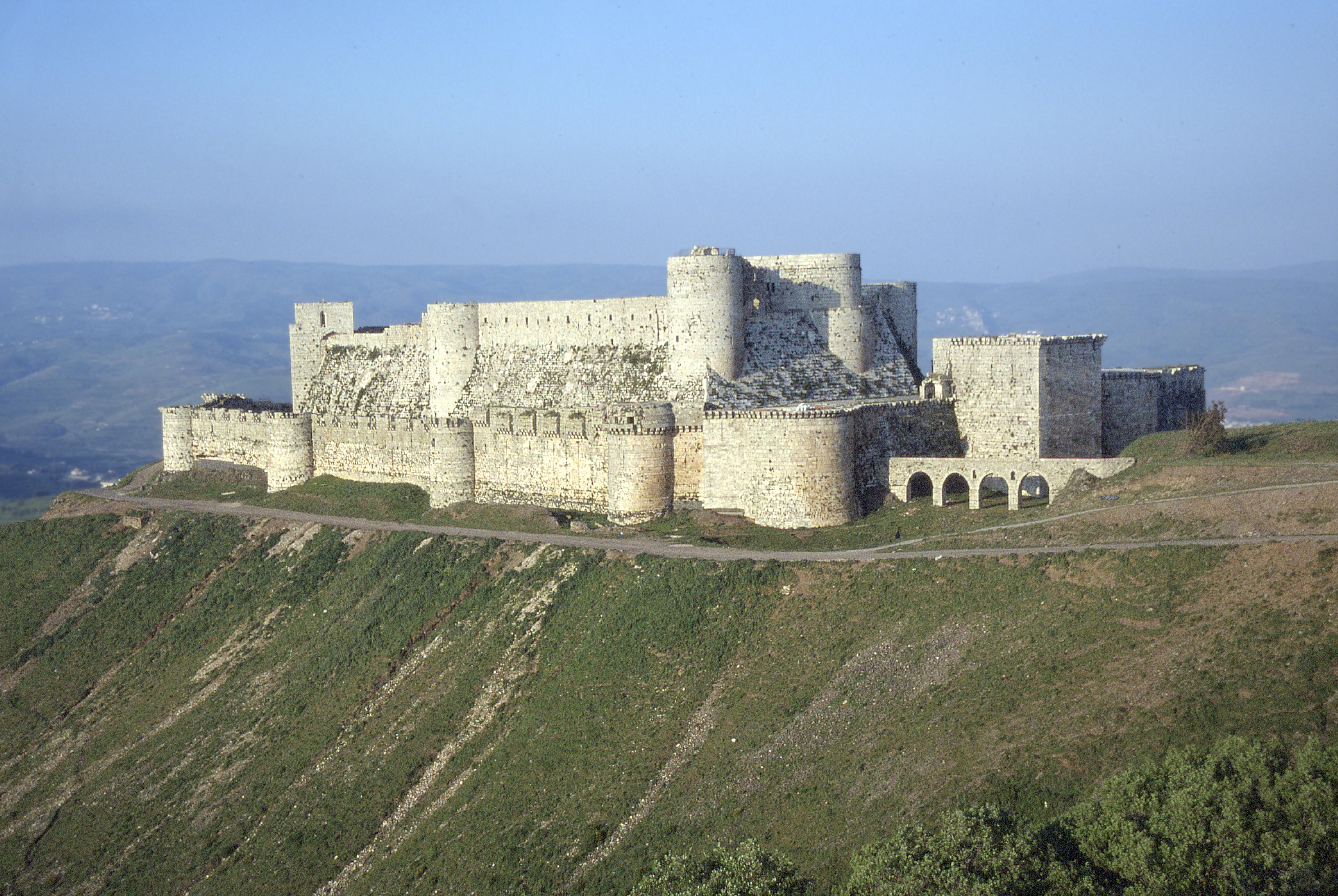
Krak des Chevaliers, ar, قلعة الحصن, Qalʿat al-Ḥiṣn also called Hisn al-Akrad ( ar, حصن الأكراد, Ḥiṣn al-Akrād, rtl=yes, ) and formerly Crac de l'Ospital; Krak des Chevaliers or Crac des Chevaliers (), is a medieval castle in Syria and one of the most important preserved medieval castles in the world. The site was first inhabited in the 11th century by Kurds, Kurdish troops garrisoned there by the Mirdasid dynasty, Mirdasids. In 1142 it was given by Raymond II of Tripoli, Raymond II, County of Tripoli, Count of Tripoli, to the order of the Knights Hospitaller. It remained in their possession until it fell in 1271. The Hospitallers began rebuilding the castle in the 1140s and were finished by 1170 when an earthquake damaged the castle. The order controlled a number of castles along the border of the County of Tripoli, a Crusader state, state founded after the First Crusade. Krak des Chevaliers was among the most important, and acted as a center ... [...More Info...] [...Related Items...] OR: [Wikipedia] [Google] [Baidu] |
Antiochian Greeks
Antiochian Greek Christians (also known as Antiochian Rūm) are a Levantine Arabic-speaking ethnoreligious Eastern Christian group residing in the Levant region. They are either members of the Greek Orthodox Church of Antioch or the Melkite Greek Catholic Church, and they have ancient roots in the Levant, more specifically, the territories of western Syria, northern and central Lebanon, western Jordan, and the southern Turkish province of Hatay, which includes the city of Antakya (ancient Antioch)—one of the holiest cities in Eastern Christianity. Many of their descendants now live in the global Near Eastern Christian diaspora. With Arabic becoming the lingua franca in the Levant, they primarily speak Levantine. History Early Era Syria was invaded by Greek king Alexander the Great in 333 B.C. and Antioch was founded by one of his generals, Seleucus I Nicator. Roman Era Syria was annexed by the Roman Republic in 64 B.C., by Pompey in the Third Mithridatic War. Christianity ... [...More Info...] [...Related Items...] OR: [Wikipedia] [Google] [Baidu] |
Wadi Al-Nasara
Wadi al-Nasara ( ar, وادي النصارى / ALA-LC: ''Wādī an-Naṣārá'', Greek: Κοιλάδα των Χριστιανών, ''Koiláda ton Christianón'', which both mean "Valley of Christians") is an area in western Syria, close to the Lebanese border and administratively belonging to the governorate of Homs. Most people in the area are Greek Orthodox Christians. A large part of the valley's population comes originally from Lebanon's northern Christian villages. Their migration to the nearby valley in Syria began in the mid-19th century as a result of the Mount Lebanon Civil War. The area of Wadi-Al Nasara is ecclesiastically under the Archdiocese of Akkar, which has its seat in Cheikh Taba, Lebanon. The current Greek-Orthodox Metropolitan of Akkar and Wadi al-Nasara and its dependencies (Safita and Tartus) is Mgr Basilius Mansour. Touristic Attractions Wadi al-Nasara used to be a popular tourist site before the outbreak of the Syrian civil war. Among its tourist ... [...More Info...] [...Related Items...] OR: [Wikipedia] [Google] [Baidu] |
Syria
Syria ( ar, سُورِيَا or سُورِيَة, translit=Sūriyā), officially the Syrian Arab Republic ( ar, الجمهورية العربية السورية, al-Jumhūrīyah al-ʻArabīyah as-Sūrīyah), is a Western Asian country located in the Eastern Mediterranean and the Levant. It is a unitary republic that consists of 14 governorates (subdivisions), and is bordered by the Mediterranean Sea to the west, Turkey to the north, Iraq to the east and southeast, Jordan to the south, and Israel and Lebanon to the southwest. Cyprus lies to the west across the Mediterranean Sea. A country of fertile plains, high mountains, and deserts, Syria is home to diverse ethnic and religious groups, including the majority Syrian Arabs, Kurds, Turkmens, Assyrians, Armenians, Circassians, Albanians, and Greeks. Religious groups include Muslims, Christians, Alawites, Druze, and Yazidis. The capital and largest city of Syria is Damascus. Arabs are the largest ethnic group, and Mu ... [...More Info...] [...Related Items...] OR: [Wikipedia] [Google] [Baidu] |
Taldou
Taldou ( ar, تلدو, Talldū, also spelled Tall Daww, Taldo, Tall Dhu or Taldao) is a town in the Houla region of northern Syria, north of Homs in the Homs Governorate. Nearby towns include Burj al-Qa'i to the east, Tallaf to the northeast, Kafr Laha and Tell Dahab to the north, Qarmas and Maryamin to the northwest, al-Taybah al-Gharbiyah and al-Shinyah to the west, Kabu to the southwest, Sharqliyya to the south and Ghur Gharbiyah to the southeast. In 2004 it had a population of 15,727 according to the Syria Central Bureau of Statistics.General Census of Population and Housing 2004 . Syria Central Bureau of Statistics (CBS). Homs Govern ... [...More Info...] [...Related Items...] OR: [Wikipedia] [Google] [Baidu] |
Mantiqah
Minṭaqah ( ; plural ''manāṭiq'' ) is a first-level administrative division in Saudi Arabia and Chad and for a second-level administrative division in several other Arab countries. It is often translated as ''region'' or ''district'', but the literal meaning is "region", "area", or even simply "place". Usage * Areas of Kuwait (second-level, below governorates) * Regions of Bahrain (formerly, top-level, replaced by governorates) * Regions of Oman (formerly, top-level, alongside governorates, now only governorates) * Regions of Chad (top-level) * Regions of Saudi Arabia (top-level, above governorates) * Districts of Syria (second-level, below governorates) - A ''mintaqah'' in Syria was formerly called ''qadaa''. * Districts of Israel There are six main administrative districts of Israel, known in Hebrew as ''mekhozot'' (; singular: ''makhoz'' ) and Arabic as ''mintaqah'' and fifteen sub-districts known as ''nafot'' (; singular: ''nafa'' ). Each sub-district is further divide ... [...More Info...] [...Related Items...] OR: [Wikipedia] [Google] [Baidu] |
United Nations Office For The Coordination Of Humanitarian Affairs
The United Nations Office for the Coordination of Humanitarian Affairs (OCHA) is a United Nations (UN) body established in December 1991 by the General Assembly to strengthen the international response to complex emergencies and natural disasters. It is the successor to the Office of the United Nations Disaster Relief Coordinator (UNDRO). The Department of Humanitarian Affairs (DHA) was established shortly thereafter by the Secretary-General, but in 1998 was merged into OCHA, which became the UN's main focal point on major disasters. OCHA's mandate was subsequently broadened to include coordinating humanitarian response, policy development and humanitarian advocacy. Its activities include organizing and monitoring humanitarian funding, advocacy, policy-making, and information exchange to facilitate rapid-response teams for emergency relief. OCHA is led by the Under-Secretary-General for Humanitarian Affairs and Emergency Relief Coordinator (USG/ERC), appointed for a five-year t ... [...More Info...] [...Related Items...] OR: [Wikipedia] [Google] [Baidu] |

_(10004827914).jpg)

