|
Tagnone
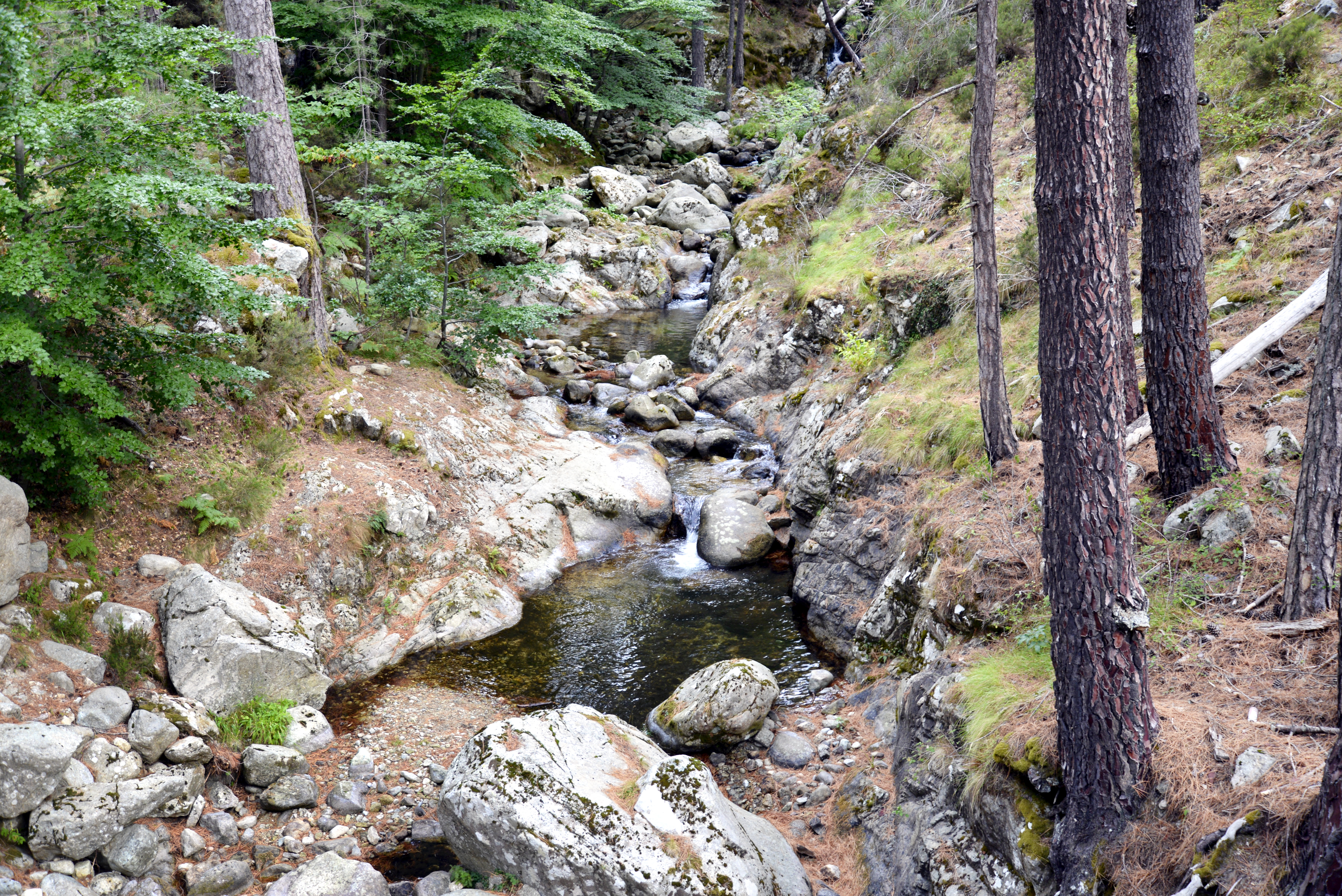
The Tagnone is a small river in the department of Haute-Corse, Corsica, France. It is a tributary of the river Tavignano. Course The Tagnone is long. It crosses the communes of Aghione, Aléria, Pietroso and Vezzani. The Tagnone rises in the commune of Vezzani to the northeast of the Punta Paglia. It run east past the village of Vezzani, then runs in a generally southeast direction to its confluence with the Tavignano south of Aléria, near the mouth of the Tavignano on the Tyrrhenian Sea. The D343 road follows the Tagnone for much of its course. Valley The Tagnone valley lies between the Tavignanu and Fium'Orbu valleys. It is smaller than these valleys and more isolated. The head of the valley is the ridge that connects the Punta della Pinghella to the Punta Paglia. To the north the valley is flanked by relatively low slopes. To the south it is separated from the Fium'Orbu valley by a line of heights that are above high until the edge of the coastal plain. The villages o ... [...More Info...] [...Related Items...] OR: [Wikipedia] [Google] [Baidu] |
Aghione
Aghione is a commune in the Haute-Corse department of France on the island of Corsica. The inhabitants of the commune are known as ''Aghionais'' or ''Aghionaises'' Geography Aghion is located on the eastern plains of Corsica 5 km west of Aleria. It can be accessed by the D343 road which comes from the National Highway N198 in the south east and passes west through the southern plain of the commune to Maison Pierraggi in the west and continues on to Vezzani in the Tagnone Valley away. From the D343 the D443 branches north at the hamlet of Samuleto and continues to the village before continuing north by a tortuous mountain route to Casevecchie. The commune is watered by the Tagnone, a tributary of Tavignano that separates an area of hills to the north from the plain, which is larger in area, to the south. There is a large dam with a large lake in the south of the commune. Neighbouring communes and villages History During the Second World War Aghione aerodrome was used ... [...More Info...] [...Related Items...] OR: [Wikipedia] [Google] [Baidu] |
Tavignano
The Tavignano (; co, Tavignanu) is a river on the island of Corsica, France. Course The Tavignano is long. In antiquity the river was known as the ''Rhotanus'' or Ῥότανος. It crosses the communes of Aléria, Altiani, Antisanti, Casamaccioli, Corte, Erbajolo, Giuncaggio, Piedicorte-di-Gaggio, Poggio-di-Venaco, Riventosa, Santa-Lucia-di-Mercurio, Santo-Pietro-di-Venaco and Venaco. The Tavignano rises below the Capu a u Tozzu and flows to the east. It runs through Lac de Nino near its source. Part of the river's upper section flows through the Réserve biologique intégrale du Tavignano. It then flows through the town of Corte. From Corte it runs southeast to the Tyrrhenian Sea near Aléria, followed by the T50 road. it enters the sea between the Étang de Diane and the Étang del Sale. Its entire course is in the Haute-Corse ''département''. Hydrology File:IMG 1459 Lac de Nino 13 10 2017.JPG, Lac de Nino near the source of the Tavignano File:Altiani-Tavignano a ... [...More Info...] [...Related Items...] OR: [Wikipedia] [Google] [Baidu] |
Aléria
Aléria (; Ancient Greek: /, ; Latin and Italian: ; co, U Cateraghju) is a commune in the Haute-Corse department of France on the island of Corsica, former bishopric and present Latin Catholic titular see. It includes the easternmost point in Metropolitan France. Administration Aléria shares the canton of Moïta-Verde with 13 other communes: Moïta, Ampriani, Campi, Canale-di-Verde, Chiatra, Linguizzetta, Matra, Pianello, Pietra-di-Verde, Tallone, Tox, Zalana and Zuani.. Geography Aléria is to the south of Bastia on Route N198, in the centre of the Plaine Orientale, also called the Plaine d'Aléria, the east-central coastal plain of the island facing Italy. It includes a number of villages and monuments. Most of the rest of the island is precipitously mountainous. The eastern coastline is punctuated by a number of lakes connecting (but not always) to the Tyrrhenian Sea, the remnant of an ancient system of lagoons behind barrier beaches. The Corsicans refer to them u ... [...More Info...] [...Related Items...] OR: [Wikipedia] [Google] [Baidu] |
France
France (), officially the French Republic ( ), is a country primarily located in Western Europe. It also comprises of overseas regions and territories in the Americas and the Atlantic, Pacific and Indian Oceans. Its metropolitan area extends from the Rhine to the Atlantic Ocean and from the Mediterranean Sea to the English Channel and the North Sea; overseas territories include French Guiana in South America, Saint Pierre and Miquelon in the North Atlantic, the French West Indies, and many islands in Oceania and the Indian Ocean. Due to its several coastal territories, France has the largest exclusive economic zone in the world. France borders Belgium, Luxembourg, Germany, Switzerland, Monaco, Italy, Andorra, and Spain in continental Europe, as well as the Netherlands, Suriname, and Brazil in the Americas via its overseas territories in French Guiana and Saint Martin. Its eighteen integral regions (five of which are overseas) span a combined area of and contain clos ... [...More Info...] [...Related Items...] OR: [Wikipedia] [Google] [Baidu] |
Corsica
Corsica ( , Upper , Southern ; it, Corsica; ; french: Corse ; lij, Còrsega; sc, Còssiga) is an island in the Mediterranean Sea and one of the 18 regions of France. It is the fourth-largest island in the Mediterranean and lies southeast of the French mainland, west of the Italian Peninsula and immediately north of the Italian island of Sardinia, which is the land mass nearest to it. A single chain of mountains makes up two-thirds of the island. , it had a population of 349,465. The island is a territorial collectivity of France. The regional capital is Ajaccio. Although the region is divided into two administrative departments, Haute-Corse and Corse-du-Sud, their respective regional and departmental territorial collectivities were merged on 1 January 2018 to form the single territorial collectivity of Corsica. As such, Corsica enjoys a greater degree of autonomy than other French regional collectivities; for example, the Corsican Assembly is permitted to exercise li ... [...More Info...] [...Related Items...] OR: [Wikipedia] [Google] [Baidu] |
Haute-Corse
Haute-Corse (; co, Corsica suprana , or ; en, Upper Corsica) is (as of 2022) an administrative department of France, consisting of the northern part of the island of Corsica. The corresponding departmental territorial collectivity merged with that of Corse-du-Sud on 1 January 2018, forming the single territorial collectivity of Corsica, with territorial elections coinciding with the dissolution of the separate councils. However, even though its administrative powers were ceded to the new territorial collectivity, it continues to remain an administrative department in its own right. In 2019, it had a population of 181,933.Populations légales 2019: 2B Haute-Corse INSEE History [...More Info...] [...Related Items...] OR: [Wikipedia] [Google] [Baidu] |
Pietroso
Pietroso (; co, U Petrosu) is a commune in the Haute-Corse department of France on the island of Corsica. Population See also *Communes of the Haute-Corse department The following is a list of the 236 communes of the Haute-Corse department of France. The communes cooperate in the following intercommunalities (as of 2020):Communes of Haute-Corse {{HauteCorse-geo-stub ... [...More Info...] [...Related Items...] OR: [Wikipedia] [Google] [Baidu] |
Vezzani
Vezzani is a commune in the Haute-Corse department of France on the island of Corsica. Population See also *Communes of the Haute-Corse department The following is a list of the 236 communes of the Haute-Corse department of France. The communes cooperate in the following intercommunalities (as of 2020):Communes of Haute-Corse {{HauteCorse-geo-stub ... [...More Info...] [...Related Items...] OR: [Wikipedia] [Google] [Baidu] |
Tyrrhenian Sea
The Tyrrhenian Sea (; it, Mar Tirreno , french: Mer Tyrrhénienne , sc, Mare Tirrenu, co, Mari Tirrenu, scn, Mari Tirrenu, nap, Mare Tirreno) is part of the Mediterranean Sea off the western coast of Italy. It is named for the Tyrrhenian people identified with the Etruscans of Italy. Geography The sea is bounded by the islands of Corsica and Sardinia (to the west), the Italian Peninsula (regions of Tuscany, Lazio, Campania, Basilicata, and Calabria) to the north and east, and the island of Sicily (to the south). The Tyrrhenian Sea also includes a number of smaller islands like Capri, Elba, Ischia, and Ustica. The maximum depth of the sea is . The Tyrrhenian Sea is situated near where the African and Eurasian Plates meet; therefore mountain chains and active volcanoes such as Mount Marsili are found in its depths. The eight Aeolian Islands and Ustica are located in the southern part of the sea, north of Sicily. Extent The International Hydrographic Organization defin ... [...More Info...] [...Related Items...] OR: [Wikipedia] [Google] [Baidu] |
Fium'Orbu
The Fiumorbo ( co, U Fium'Orbu) is a coastal river in the department of Haute-Corse, Corsica, France. It is dammed in two places to supply irrigation water and hydroelectricity. Between the two dams it runs through the spectacular Défilé de l’Inzecca, a Natura 2000 site. Course The Fiumorbo is long. It crosses the communes of Bastelica, Palneca, Ghisonaccia, Ghisoni, Lugo-di-Nazza, Poggio-di-Nazza, Prunelli-di-Fiumorbo and Serra-di-Fiumorbo. The Fiumorbo rises in the commune of Palneca, Corse-du-sud, to the north of the Monte Giovanni. It forms the border between Palneca and Bastelica as it flows north, then northeast, entering the commune of Ghisoni, Haute-Corse. It continues northeast and north through the Forêt de Marmano, then turns east to the hamlet of Sampolo, where it is dammed to form the Réservoir de Sampolo. Below the Barrage de Sampolo it flows east through the Défilé de l'Inzecca down to the coastal plain, where it is dammed by the Barrage de Trevadin ... [...More Info...] [...Related Items...] OR: [Wikipedia] [Google] [Baidu] |
Laricio Pine
''Pinus nigra'', the Austrian pine or black pine, is a moderately variable species of pine, occurring across Southern Europe from the Iberian Peninsula to the eastern Mediterranean, on the Anatolian peninsula of Turkey, Corsica and Cyprus, as well as Crimea and in the high mountains of Northwest Africa. Description ''Pinus nigra'' is a large coniferous evergreen tree, growing to high at maturity and spreading to wide. The bark is gray to yellow-brown, and is widely split by flaking fissures into scaly plates, becoming increasingly fissured with age. The leaves ('needles') are thinner and more flexible in western populations. The ovulate and pollen cones appear from May to June. The mature seed cones are (rarely to 11 cm) long, with rounded scales; they ripen from green to pale gray-buff or yellow-buff in September to November, about 18 months after pollination. The seeds are dark gray, long, with a yellow-buff wing long; they are wind-dispersed when the cones open fr ... [...More Info...] [...Related Items...] OR: [Wikipedia] [Google] [Baidu] |
Maquis Shrubland
220px, Low maquis in Corsica 220px, High ''macchia'' in Sardinia ( , , ) or ( , ; often in Italian; hr, makija; ; ) is a shrubland biome in the Mediterranean region, typically consisting of densely growing evergreen shrubs. Maquis is characterized by plants of the family Lamiaceae, genera '' Laurus'' and '' Myrtus'', and species '' Olea europaea'', ''Ceratonia siliqua'', and ''Ficus carica The fig is the edible fruit of ''Ficus carica'', a species of small tree in the flowering plant family Moraceae. Native to the Mediterranean and western Asia, it has been cultivated since ancient times and is now widely grown throughout the world ...''. It is similar to garrigue. See also * Mining maquis * Maquis (other) * Mediterranean forests, woodlands, and scrub References External links * * * {{DEFAULTSORT:Maquis Shrubland * Ecoregions of Europe Ecoregions of Metropolitan France Environment of the Mediterranean Mediterranean forests, woodlands, and s ... [...More Info...] [...Related Items...] OR: [Wikipedia] [Google] [Baidu] |


