|
Taganrog Fortress
Taganrog Fortress (also The Saint Trinity fortress on Tagan-Rog Cape) was a star fort-style fortress built during the reign of Peter the Great and re-constructed by the order of Catherine the Great. Foundation of Taganrog Peter the Great tried to conquer the Turkish fortress of Azov to get an entrance to the Sea of Azov and the Black Sea. His first Azov campaigns in 1695 failed, but his second attempt the next year led to victory. To ensure Russian positions in the South, and to shelter the Russian Navy, Peter the Great needed a new haven for the Azov Flotilla, and a fortress to protect it. Azov could not serve as naval base because of shallow waters of the river Don. That is why, a few days after Turkish capitulation, on July 27, 1696 the Russian tsar set out for an expedition to explore the coastline of Azov Sea. The expedition stopped at the cape Tagan-Rog on July 27, where Peter the Great spent the night of July 27–28, 1696. The cape was selected as the perfect place for t ... [...More Info...] [...Related Items...] OR: [Wikipedia] [Google] [Baidu] |
Taganrog
Taganrog ( rus, Таганрог, p=təɡɐnˈrok) is a port city in Rostov Oblast, Russia, on the north shore of the Taganrog Bay in the Sea of Azov, several kilometers west of the mouth of the Don River. Population: History of Taganrog The history of the city goes back to the late Bronze Age–early Iron Age (between the 20th and 10th centuries BC), when it was the earliest Greek settlement in the northwestern Black Sea Region and was mentioned by the Greek historian Herodotus as Emporion Kremnoi. In the 13th century, Pisan merchants founded a colony, Portus Pisanus, which was however short-lived. Taganrog was founded by Peter the Great on 12 September 1698. The first Russian Navy base, it hosted the Azov Flotilla of Catherine the Great (1770–1783), which subsequently became the Russian Black Sea Fleet. Taganrog was granted city status in 1775. By the end of the 18th century, Taganrog had lost its importance as a military base after Crimea and the entire Sea of Azov w ... [...More Info...] [...Related Items...] OR: [Wikipedia] [Google] [Baidu] |
Izba
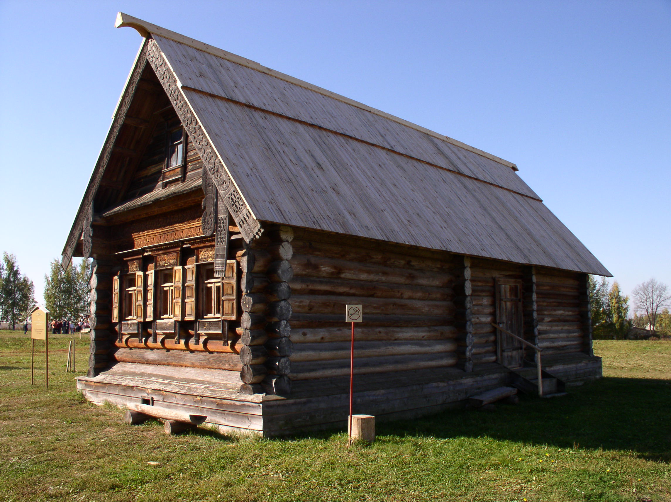
An izba ( rus, изба́, p=ɪzˈba, a=Ru-изба.ogg) is a traditional Slavic countryside dwelling. Often a log house, it forms the living quarters of a conventional Russian farmstead. It is generally built close to the road and inside a yard, which also encloses a kitchen garden, hay shed, and barn within a simple woven stick fence. Traditional, old-style izba construction involved the use of simple tools, such as ropes, axes, knives, and spades. Nails were not generally used, as metal was relatively expensive, and neither were saws a common construction tool. Both interior and exterior are of split pine tree trunks, the gap between is traditionally filled with river clay, not unlike the North American log cabin. The dominant building material of Russian vernacular architecture, and material culture generally, for centuries was wood. Specifically houses were made from locally-cut rough-hewn logs, with little or no stone, metal, or glass. Even churches and urban buildings w ... [...More Info...] [...Related Items...] OR: [Wikipedia] [Google] [Baidu] |
Artificial Island
An artificial island is an island that has been constructed by people rather than formed by natural means. Artificial islands may vary in size from small islets reclaimed solely to support a single pillar of a building or structure to those that support entire communities and cities. Early artificial islands included floating structures in still waters or wooden or megalithic structures erected in shallow waters (e.g. crannógs and Nan Madol discussed below). In modern times artificial islands are usually formed by land reclamation, but some are formed by the incidental isolation of an existing piece of land during canal construction (e.g. Donauinsel, Ko Kret, and much of Door County, Wisconsin), or flooding of valleys resulting in the tops of former knolls getting isolated by water (e.g., Barro Colorado Island). One of the world's largest artificial islands, René-Levasseur Island, was formed by the flooding of two adjacent reservoirs. History Despite a popular image of mode ... [...More Info...] [...Related Items...] OR: [Wikipedia] [Google] [Baidu] |
Cherepakha Islet
Cherepakha or Cherepashka (literally "The Turtle") was a small artificial islet, which was man-made on a sand bank in the Gulf of Taganrog on Azov Sea in about 2 kilometers from the Taganrog Fortress. Its sole purpose was to support the fortification with cannons thus creating additional defense for the Azov Flotilla. History The islet was built by the personal order of Peter the Great in 1701-1706 of rock fill held by oak piles. It was oval-shaped and measured 59 by 38 meters. There was a citadel, which had an area of 1200 square meters with 127 cannons. In the middle stood a wooden izba for garrison, which was later replaced by a stone building. The part of the islet above water level was covered with white limestones. The name ''Cherepakha'' (the Turtle) is due to the many seashells laid in its foundation when the sand bank was being raised. After a defeat suffered by Russian troops from Ottoman Empire during Pruth River Campaign, the Russian tsar had to sign Treaty of the Pru ... [...More Info...] [...Related Items...] OR: [Wikipedia] [Google] [Baidu] |
Sloboda
A sloboda ( rus, слобода́, p=sləbɐˈda) was a kind of settlement in the history of the Old Russian regions Povolzhye, Central Russia, Belarus and Ukraine. The name is derived from the early Slavic word for "freedom" and may be loosely translated as "(tax-)free settlement"."Sloboda" '''' (1890–1906) In modern Russia, the term is used to denote a type of a rural locality in |
Peter Barracks (Taganrog)
Peter barracks ('' rus, Петровские казармы'') — a historical monument in Taganrog, Russia, that was built at the end of the 18th century. Is a part of «combined arms cell» of Taganrog Fortress. It is also a valuable object of cultural heritage of federal importance. History On 7 December 1803, the garrison battalion of st. Dmitry of Rostov Fortress were moved to Taganrog. It was planned to form there a regiment that would consist of two battalions, so the construction of new barracks for this purpose began.''Назаренко И. В.'' Казарма времен Александра I / Таганрог. Энциклопедия. — Таганрог: Антон, 2008. — С. 371. — . Nowadays only one «standard» building still stands. In the 1910s the building was occupied by a penitentiary orphanage. In the 1920s there was a prison for juvenile offenders. In 1937 the buildings were redesigned for living spaces. Museum By 1998, the barracks wer ... [...More Info...] [...Related Items...] OR: [Wikipedia] [Google] [Baidu] |
Ravelin
A ravelin is a triangular fortification or detached outwork, located in front of the innerworks of a fortress (the curtain walls and bastions). Originally called a ''demi-lune'', after the ''lunette'', the ravelin is placed outside a castle and opposite a fortification curtain wall. The ravelin is the oldest and at the same time the most important outer work of the bastion fortification system. It originated from small forts that were supposed to cover the bridge that led across the moat to the city or fortress gate from a direct attack. From this original function, to protect the gate bridge, also comes its original Italian name "''rivellino''" (which means small bank work or with the German expression common for it: ''Brückenkopf'' – "bridge head"). Therefore, the ravelin was at first only a small work, which should only make the access to the bridge in front of the fortress gates more difficult. When it was realized in the 16th century that this would generally provid ... [...More Info...] [...Related Items...] OR: [Wikipedia] [Google] [Baidu] |
Bastion
A bastion or bulwark is a structure projecting outward from the curtain wall of a fortification, most commonly angular in shape and positioned at the corners of the fort. The fully developed bastion consists of two faces and two flanks, with fire from the flanks being able to protect the curtain wall and the adjacent bastions. Compared with the medieval fortified towers they replaced, bastion fortifications offered a greater degree of passive resistance and more scope for ranged defence in the age of gunpowder artillery. As military architecture, the bastion is one element in the style of fortification dominant from the mid 16th to mid 19th centuries. Evolution By the middle of the 15th century, artillery pieces had become powerful enough to make the traditional medieval round tower and curtain wall obsolete. This was exemplified by the campaigns of Charles VII of France who reduced the towns and castles held by the English during the latter stages of the Hundred Years War, ... [...More Info...] [...Related Items...] OR: [Wikipedia] [Google] [Baidu] |
Earth
Earth is the third planet from the Sun and the only astronomical object known to harbor life. While large volumes of water can be found throughout the Solar System, only Earth sustains liquid surface water. About 71% of Earth's surface is made up of the ocean, dwarfing Earth's polar ice, lakes, and rivers. The remaining 29% of Earth's surface is land, consisting of continents and islands. Earth's surface layer is formed of several slowly moving tectonic plates, which interact to produce mountain ranges, volcanoes, and earthquakes. Earth's liquid outer core generates the magnetic field that shapes the magnetosphere of the Earth, deflecting destructive solar winds. The atmosphere of the Earth consists mostly of nitrogen and oxygen. Greenhouse gases in the atmosphere like carbon dioxide (CO2) trap a part of the energy from the Sun close to the surface. Water vapor is widely present in the atmosphere and forms clouds that cover most of the planet. More solar e ... [...More Info...] [...Related Items...] OR: [Wikipedia] [Google] [Baidu] |
Don River, Russia
The Don ( rus, Дон, p=don) is the fifth-longest river in Europe. Flowing from Central Russia to the Sea of Azov in Southern Russia, it is one of Russia's largest rivers and played an important role for traders from the Byzantine Empire. Its basin is between the Dnieper basin to the west, the lower Volga basin immediately to the east, and the Oka basin (tributary of the Volga) to the north. Native to much of the basin were Slavic nomads. The Don rises in the town of Novomoskovsk southeast of Tula (in turn south of Moscow), and flows 1,870 kilometres to the Sea of Azov. The river's upper half ribbles (meanders subtly) south; however, its lower half consists of a great eastern curve, including Voronezh, making its final stretch, an estuary, run west south-west. The main city on the river is Rostov-on-Don. Its main tributary is the Seversky Donets, centred on the mid-eastern end of Ukraine, thus the other country in the overall basin. To the east of a series of three ... [...More Info...] [...Related Items...] OR: [Wikipedia] [Google] [Baidu] |


.jpg)
