|
Tabuaeran
Tabuaeran, also known as Fanning Island, is an atoll that is part of the Line Islands of the central Pacific Ocean and part of Kiribati. The land area is , and the population in 2015 was 2,315. The maximum elevation is about 3 m (10 ft) above high tide. The lagoon has an area of . The deepest water in the lagoon is about , but most of it is very shallow. History Tabuaeran was first inhabited by Polynesian people. Archaeological evidence points to a single large village being maintained for several hundred years on the west side of the atoll with other scattered production and agricultural sites across the atoll. Radiometric dates range from 1100 CE to 1425 CE (Cal. 810 ±50 BP and 620 ± 60 BP at 2 sigma). Continuous habitation is likely as stratigraphic cultural layers are uninterrupted and quite deep. Some archaeologists have argued that Tabuaeran and Kiritimati were one community living across a matched set of islands as despite their relative proximity, their cl ... [...More Info...] [...Related Items...] OR: [Wikipedia] [Google] [Baidu] |
Line Islands
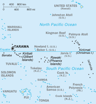
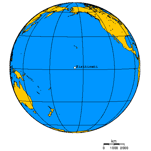
The Line Islands, Teraina Islands or Equatorial Islands (in Gilbertese, ''Aono Raina'') are a chain of 11 atolls (with partly or fully enclosed lagoons) and coral islands (with a surrounding reef) in the central Pacific Ocean, south of the Hawaiian Islands. The island chain stretches northwest to southeast across , making it one of the longest island chains in the world. It lies at the geographic center of the Pacific Ocean (), near Starbuck Island. One of the atolls in the group, Kiritimati, has the largest land area of any atoll in the world. Of the 11 atolls, all of which were formed by volcanic activity, only the Kiritimati and Tabuaeran atolls and Teraina island have a permanent population (one of the reefs, Filippo Reef, is shown on some maps, but its existence is doubted). Eight of the atolls are parts of Kiribati. The remaining three—Jarvis Island, Kingman Reef (which is largely submerged), and Palmyra Atoll—are territories of the United States grouped with the United ... [...More Info...] [...Related Items...] OR: [Wikipedia] [Google] [Baidu] |
Kiritimati
Kiritimati (also known as Christmas Island) is a Pacific Ocean atoll in the northern Line Islands. It is part of the Republic of Kiribati. The name is derived from the English word "Christmas" written in Gilbertese according to its phonology, in which the combination ''ti'' is pronounced ''s'', giving kiˈrɪsmæs. Kiritimati has the greatest land area of any atoll in the world, about ; its lagoon is roughly the same size. The atoll is about in perimeter, while the lagoon shoreline extends for over . Kiritimati comprises over 70% of the total land area of Kiribati, a country encompassing 33 Pacific atolls and islands. It lies north of the equator, south of Honolulu, and from San Francisco. Kiritimati is in the world's farthest forward time zone, UTC+14, and is therefore one of the first inhabited places on Earth to experience New Year's Day. (see also Caroline Atoll, Kiribati). Although it lies east of the 180th meridian, the Republic of Kiribati realigned the Internati ... [...More Info...] [...Related Items...] OR: [Wikipedia] [Google] [Baidu] |
Napari
Napari or Napali is a settlement located at the north end of Tabuaeran atoll, Kiribati. In the 2002 census 194 people were recorded as living in Napali. While Napali was not listed in the 2010 census as having any residents, the city of Tereitaki Tereitaki is a settlement located towards the north end of Tabuaeran atoll, Kiribati. Napari Napari or Napali is a settlement located at the north end of Tabuaeran atoll, Kiribati Kiribati (), officially the Republic of Kiribati ( gi ... on the southern Napali was reported as having 346 inhabitants. References Populated places in Kiribati {{Kiribati-geo-stub ... [...More Info...] [...Related Items...] OR: [Wikipedia] [Google] [Baidu] |
Gilbert And Ellice Islands
The Gilbert and Ellice Islands (GEIC as a colony) in the Pacific Ocean were part of the British Empire from 1892 to 1976. They were a protectorate from 1892 to 12 January 1916, and then a colony until 1 January 1976. The history of the colony was mainly characterized by phosphate mining on Ocean Island. In October 1975, these islands were divided by force of law into two separate colonies, and they became independent nations shortly thereafter: the Ellice Islands became Tuvalu in 1978, and the Gilbert Islands became part of Kiribati in 1979. Location The Gilbert IslandsReilly Ridgell. ''Pacific Nations and Territories: The Islands of Micronesia, Melanesia, and Polynesia.'' 3rd. Ed. Honolulu: Bess Press, 1995. p. 95. (sometimes also known as ''Kingsmill Islands''Very often, this name applied only to the southern islands of the archipelago. ''Merriam-Webster's Geographical Dictionary''. Springfield, Massachusetts: Merriam Webster, 1997. p. 594.) are a chain of sixteen atolls and ... [...More Info...] [...Related Items...] OR: [Wikipedia] [Google] [Baidu] |
Kiribati
Kiribati (), officially the Republic of Kiribati ( gil, ibaberikiKiribati),Kiribati ''The World Factbook''. Europa (web portal). Retrieved 29 January 2016. is an in in the central . The permanent population is over 119,000 (2020), more than half of whom live on |
Betania, Kiribati
Betania is a settlement located on Tabuaeran atoll, Kiribati.http://www.yr.no/place/Kiribati/Line_Islands/Betania_Village/ Betania Tereitaki is to the north; with Paelau Paelau is a settlement located on Tabuaeran atoll, Kiribati Kiribati (), officially the Republic of Kiribati ( gil, ibaberikiKiribati), References Populated places in Kiribati {{Kiribati-geo-stub ...[...More Info...] [...Related Items...] OR: [Wikipedia] [Google] [Baidu] |
Paelau
Paelau is a settlement located on Tabuaeran atoll, Kiribati. It is located on the western side of the atoll, south of a passage into the lagoon, with Betania to the north and Aontenaa Aontenaa is a settlement located on Tabuaeran atoll, Kiribati. Paelau Paelau is a settlement located on Tabuaeran atoll, Kiribati Kiribati (), officially the Republic of Kiribati ( gil, ibaberikiKiribati), It was formerly known as Napia or English Harbour. References Populated places in Kiribati {{Kiribati-geo-stub ...[...More Info...] [...Related Items...] OR: [Wikipedia] [Google] [Baidu] |
Tereitaki
Tereitaki is a settlement located towards the north end of Tabuaeran atoll, Kiribati. Napari Napari or Napali is a settlement located at the north end of Tabuaeran atoll, Kiribati. In the 2002 census 194 people were recorded as living in Napali. While Napali was not listed in the 2010 census as having any residents, the city of Tereitak ... is the northernmost settlement; with Betania to the south. In the 2010 census 346 people were recorded as living in Tereitaki. References Populated places in Kiribati {{Kiribati-geo-stub ... [...More Info...] [...Related Items...] OR: [Wikipedia] [Google] [Baidu] |
All Red Line
The All Red Line was a system of electrical telegraphs that linked much of the British Empire. It was inaugurated on 31 October 1902. The informal name derives from the common practice of colouring the territory of the British Empire red or pink on political maps. Construction The first transatlantic cable connected Ireland and Newfoundland in 1858, although it later failed. In 1866, the laid out a lasting link from Valentia Island, in Ireland, to Heart's Content, Newfoundland. By 1870, Suez was linked to Bombay, and from there to Madras, Penang, and Singapore. Australia was linked to British telegraph cables directly in 1871, by extending a line from Singapore to Port Darwin, although it ran through the Dutch territory of Java. By 1872, messages could be sent direct from London to Adelaide and Sydney. Australia was linked to New Zealand by cable in 1876. To complete the All Red Line, therefore, the final major cable laying project was the trans-Pacific section. A resol ... [...More Info...] [...Related Items...] OR: [Wikipedia] [Google] [Baidu] |
Teraina
Teraina (written also Teeraina, also known as Washington Island – these two names are constitutional) is a coral atoll in the central Pacific Ocean and part of the Northern Line Islands which belong to Kiribati. Obsolete names of Teraina are New Marquesas, Prospect Island, and New York Island. The island is located approximately 4.71° North latitude and 160.76° West longitude. Teraina differs from most other atolls in the world in that it has a large freshwater lake (Washington Lake), an open lens, concealed within its luxuriant coconut palm forest; this is the only permanent freshwater lake in the whole of Kiribati.Teeb'aki ''in'' Scott (1993) Measuring about NW-SE and SW-NE, it has a land area of about ; its circumference is about . The island is generally low-lying, with a maximum elevation ASL of about , while most of the island rises some high; trees in the dense inland forest grow to several times this height however. At the western end of the island is the capital ... [...More Info...] [...Related Items...] OR: [Wikipedia] [Google] [Baidu] |
Edmund Fanning
Edmund Fanning (July 16, 1769 – April 23, 1841) was an American explorer and sea captain, known as the "Pathfinder of the Pacific." Life Born in Stonington in the British Crown Colony of Connecticut to Gilbert and Huldah Fanning, from nearby Groton he went to sea as a cabin boy at the age of 14, and by the age of 24 was captain of a West Indian brig in which he visited the South Pacific for the first time. A successful trader, Fanning made a fortune in the China trade, killing seals in the South Pacific and exchanging their skins in China for silks, spices, and tea; which he in turn sold in New York City. As master of the ''Betsey'' in 1797–1798, he discovered three South Pacific Islands — Fanning, Washington, and Palmyra — which are collectively known as the Fanning Islands. (Fanning Island, today known as Tabuaeran, is today part of Kiribati, while Palmyra, claimed by the Hawaiian Government in 1862 and owned for many years by a Hawaiian family, was p ... [...More Info...] [...Related Items...] OR: [Wikipedia] [Google] [Baidu] |
Marquesas Islands
The Marquesas Islands (; french: Îles Marquises or ' or '; Marquesan: ' ( North Marquesan) and ' ( South Marquesan), both meaning "the land of men") are a group of volcanic islands in French Polynesia, an overseas collectivity of France in the southern Pacific Ocean. Their highest point is the peak of Mount Oave (french: Mont Oave, links=no) on Ua Pou island, at 1,230 m (4,035 ft) above sea level. Archaeological research suggests the islands were colonized in the 10th century AD by voyagers from West Polynesia. Over the centuries that followed, the islands have maintained a "remarkably uniform culture, biology and language". The Marquesas were named after the 16th century Spanish Viceroy of Peru, the Marquis of Cañete ( es, Marqués de Cañete, italic=unset) by navigator , who visited them in 1595. The Marquesas Islands constitute one of the five administrative divisions (') of French Polynesia. The capital of the Marquesas Islands' administrative subdivision is t ... [...More Info...] [...Related Items...] OR: [Wikipedia] [Google] [Baidu] |


_MAP_OF_THE_TOKELU%2C_ELLICE_AND_GILBERT_ISLANDS.jpg)


