|
Sutton Courtenay
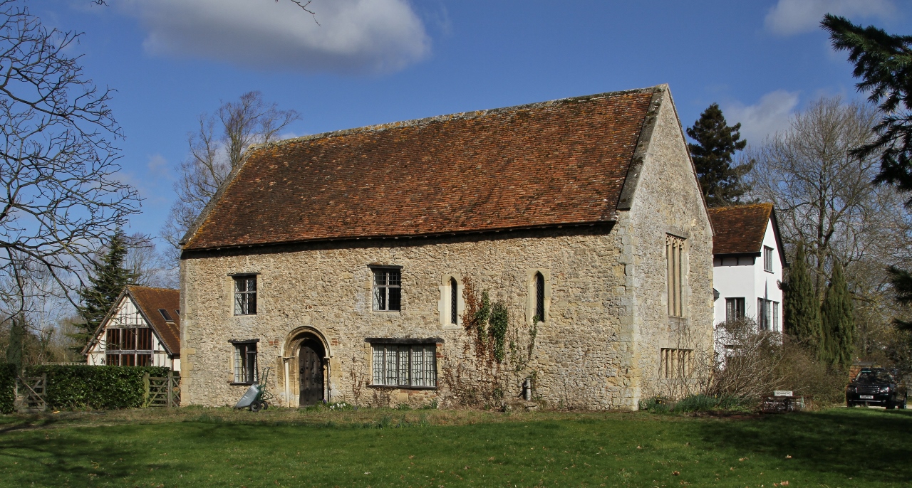
Sutton Courtenay is a village and civil parish on the River Thames south of Abingdon-on-Thames and northwest of Didcot. Historically part of Berkshire, it has been administered as part of Oxfordshire since the 1974 boundary changes. The 2011 Census recorded the parish's population as 2,421. Sutton Courtenay is home to some important structures, such as The Abbey, the Manor House, All Saints' Church, a twelfth-century Norman hall, the Sutton Bridge, and Didcot power station. Archaeology and history A Neolithic stone hand axe was found at Sutton Courtenay. Petrological analysis in 1940 identified the stone as epidotised tuff from Stake Pass in the Lake District, to the north. Stone axes from the same source have been found at Abingdon, Alvescot, Kencot and Minster Lovell. Excavations have revealed rough Saxon huts from the early stages of Anglo-Saxon settlement of Britain, but their most important enduring monument in Sutton was the massive causeway and weirs that separa ... [...More Info...] [...Related Items...] OR: [Wikipedia] [Google] [Baidu] |
The Abbey, Sutton Courtenay
The Abbey in Sutton Courtenay is a medieval courtyard house in the English county of Oxfordshire (formerly Berkshire). It is located in the Vale of White Horse near the River Thames, across the road from the twelfth-century Norman Hall and the Manor House. The Abbey has been recognised as a building of outstanding historic and architectural interest and is considered to be a ‘textbook’ example of an English medieval manor house. It has been a Grade I-listed building since 1952. The Abbey has its origins in the thirteenth century as a rectory of Abingdon Abbey, a Benedictine monastery up north in Abingdon-on-Thames. Several construction phases took place during the Middle Ages, carried out by prominent figures like Solomon of Rochester, Thomas Beckington and William Say, but it wasn't until the seventeenth century that the current plan was completed. It was probably during the Victorian era that the house obtained the name 'The Abbey'. From 1495 to 1867, The Abbey was in po ... [...More Info...] [...Related Items...] OR: [Wikipedia] [Google] [Baidu] |
United Kingdom Census 2011
A Census in the United Kingdom, census of the population of the United Kingdom is taken every ten years. The 2011 census was held in all countries of the UK on 27 March 2011. It was the first UK census which could be completed online via the Internet. The Office for National Statistics (ONS) is responsible for the census in England and Wales, the General Register Office for Scotland (GROS) is responsible for the census in Scotland, and the Northern Ireland Statistics and Research Agency (NISRA) is responsible for the census in Northern Ireland. The Office for National Statistics is the executive office of the UK Statistics Authority, a non-ministerial department formed in 2008 and which reports directly to Parliament. ONS is the UK Government's single largest statistical producer of independent statistics on the UK's economy and society, used to assist the planning and allocation of resources, policy-making and decision-making. ONS designs, manages and runs the census in England an ... [...More Info...] [...Related Items...] OR: [Wikipedia] [Google] [Baidu] |
Didcot Power Station
Didcot power station (Didcot B Power Station) is an active natural gas power plant that supplies the National Grid. A combined coal and oil power plant, Didcot A, was the first station on the site which opened in 1970 and was demolished between 2014 and 2020. The power station is situated in Sutton Courtenay, near Didcot in Oxfordshire, England. Additionally Didcot OCGT is a gas-oil power plant, originally part of Didcot A and now independent that continues to provide emergency backup power for the National Grid. A large section of the boiler house at Didcot A Power Station collapsed on 23 February 2016 while the building was being prepared for demolition. Four men were killed in the collapse. The combined power stations featured a chimney, demolished in 2020, which was one of the tallest structures in the UK, and could be seen from much of the surrounding landscape. It had previously had six hyperboloid cooling towers, three of which were demolished in 2014 and the remaining ... [...More Info...] [...Related Items...] OR: [Wikipedia] [Google] [Baidu] |
Channel 4
Channel 4 is a British free-to-air public broadcast television network operated by the state-owned enterprise, state-owned Channel Four Television Corporation. It began its transmission on 2 November 1982 and was established to provide a fourth television service in the United Kingdom. At the time, the only other channels were the television licence, licence-funded BBC One and BBC Two, and a single commercial broadcasting network ITV (TV network), ITV. The network's headquarters are based in London and Leeds, with creative hubs in Glasgow and Bristol. It is publicly owned and advertising-funded; originally a subsidiary of the Independent Broadcasting Authority (IBA), the station is now owned and operated by Channel Four Television Corporation, a public corporation of the Department for Digital, Culture, Media and Sport, which was established in 1990 and came into operation in 1993. Until 2010, Channel 4 did not broadcast in Wales, but many of its programmes were re-broadcast ... [...More Info...] [...Related Items...] OR: [Wikipedia] [Google] [Baidu] |
Sutton Pools
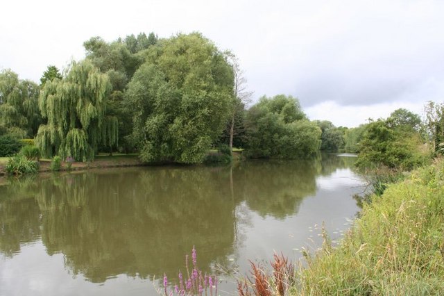
Sutton Pools are a picturesque backwater formed by a number of weirs, islands, footbridges and barriers on the course of the River Thames at Sutton Courtenay, Oxfordshire, England. The higher level of the river is separated from the lower pools by a causeway which dates from Saxon times. This river stretch ceased to be the main navigable route after Culham Cut was constructed in the early 19th century, which also created an island to the north of the Pools. In addition there are three smaller islands, linked by footbridges over the weirs, part of a footpath between Sutton Courtenay and the village of Culham Culham is a village and civil parish in a bend of the River Thames, south of Abingdon in Oxfordshire. The parish includes Culham Science Centre and Europa School UK (formerly the European School, Culham, which was the only Accredited Europea .... The upper river channel at Sutton Pools used to pass beneath a paper mill, though this closed in 1897 and has been demolishe ... [...More Info...] [...Related Items...] OR: [Wikipedia] [Google] [Baidu] |
Society Of Antiquaries Of London
A society is a group of individuals involved in persistent social interaction, or a large social group sharing the same spatial or social territory, typically subject to the same political authority and dominant cultural expectations. Societies are characterized by patterns of relationships (social relations) between individuals who share a distinctive culture and institutions; a given society may be described as the sum total of such relationships among its constituent of members. In the social sciences, a larger society often exhibits stratification or dominance patterns in subgroups. Societies construct patterns of behavior by deeming certain actions or concepts as acceptable or unacceptable. These patterns of behavior within a given society are known as societal norms. Societies, and their norms, undergo gradual and perpetual changes. Insofar as it is collaborative, a society can enable its members to benefit in ways that would otherwise be difficult on an individual b ... [...More Info...] [...Related Items...] OR: [Wikipedia] [Google] [Baidu] |
Anglo-Saxon Settlement Of Britain
The Anglo-Saxon settlement of Britain is the process which changed the language and culture of most of what became England from Romano-British to Germanic peoples, Germanic. The Germanic-speakers in Britain, themselves of diverse origins, eventually developed a common cultural identity as Anglo-Saxons. This process principally occurred from the mid-fifth to early seventh centuries, following the Roman withdrawal from Britain, end of Roman rule in Britain around the year 410. The settlement was followed by the establishment of the Heptarchy, Anglo-Saxon kingdoms in the south and east of Great Britain, Britain, later followed by the rest of modern England, and the south-east of modern Scotland. The available evidence includes the scant contemporary and near-contemporary written record, archaeological and genetic information. The few literary sources tell of hostility between incomers and natives. They describe violence, destruction, massacre, and the flight of the Romano-Britis ... [...More Info...] [...Related Items...] OR: [Wikipedia] [Google] [Baidu] |
Minster Lovell
Minster Lovell is a village and civil parish on the River Windrush about west of Witney in Oxfordshire. The 2011 Census recorded the parish's population as 1,409. Minster Lovell village has three parts: Old Minster, Little Minster and New Minster. Old Minster includes the parish church, Minster Lovell Hall and the Old Swan Inn and Minster Mill Hotel. A large part of New Minster is the Charterville Allotments, which were founded by the Chartists in 1846–50. Archaeology In 1952 a Neolithic stone hand axe was found at Minster Lovell. It is unusually large: long by wide. The geologist Professor K.C. Dunham identified it as epidotised tuff from Stake Pass in the Lake District, to the north. Stone axes from the same source have been found at Alvescot, Kencot, Abingdon and Sutton Courtenay. History The village was named ''Minstre'', situated in the ancient hundred of Bampton in 1086. The dedication of the Church of England parish church to the Saxon Saint Kenelm and the na ... [...More Info...] [...Related Items...] OR: [Wikipedia] [Google] [Baidu] |
Kencot, Oxfordshire
Kencot is a village and civil parish about south-west of Carterton in West Oxfordshire. The 2011 Census recorded the parish's population as 101. Archaeology A Neolithic stone hand axe was found at Kencot. Petrological analysis in 1940 identified the stone as epidotised tuff from Stake Pass in the Lake District, to the north. Stone axes from the same source have been found at Alvescot, Abingdon, Sutton Courtenay and Minster Lovell. Parish church The Church of England parish church of Saint George is Norman. Features from this period include the south doorway, whose tympanum contains a relief of Sagittarius shooting a monster, and a former doorway in the north wall. The openings of the chancel windows are 13th century but the windows themselves are modern. The ground stage of the bell tower was built in about 1300 and the present chancel arch was built early in the 14th century. High in the south wall of the nave are two Perpendicular Gothic windows, and the late Pe ... [...More Info...] [...Related Items...] OR: [Wikipedia] [Google] [Baidu] |
Alvescot
Alvescot is a village and civil parish about south of Carterton, Oxfordshire, England. The 2011 Census recorded the parish's population as 472. Archaeology A Neolithic stone hand axe was found at Alvescot. Petrological analysis in 1940 identified the stone as epidotised tuff from Stake Pass in the Lake District, to the north. Stone axes from the same source have been found at Kencot, Abingdon, Sutton Courtenay and Minster Lovell. Church and chapel Church of England The Church of England parish church of Saint Peter is cruciform. The font is Norman and 12th- or 13th-century. The north transept and blocked north doorway are early 13th-century. The hoodmould over the south doorway is either late 13th- or early 14th-century, and the south porch was added in the 14th century. In the 15th century the nave was rebuilt and the present Perpendicular Gothic south transept and west tower were built. In the 16th century the south wall of the south transept was rebuilt and the pr ... [...More Info...] [...Related Items...] OR: [Wikipedia] [Google] [Baidu] |
Lake District
The Lake District, also known as the Lakes or Lakeland, is a mountainous region in North West England. A popular holiday destination, it is famous for its lakes, forests, and mountains (or ''fells''), and its associations with William Wordsworth and other Lake Poets and also with Beatrix Potter and John Ruskin. The Lake District National Park was established in 1951 and covers an area of . It was designated a UNESCO World Heritage Site in 2017. The Lake District is today completely within Cumbria, a county and administrative unit created in 1974 by the Local Government Act 1972. However, it was historically divided between three English counties ( Cumberland, Westmorland and Lancashire), sometimes referred to as the Lakes Counties. The three counties met at the Three Shire Stone on Wrynose Pass in the southern fells west of Ambleside. All the land in England higher than above sea level lies within the National Park, including Scafell Pike, the highest mountain in England. ... [...More Info...] [...Related Items...] OR: [Wikipedia] [Google] [Baidu] |
Rossett Pike
Rossett Pike is a fell in the English Lake District. It is located at the head of Mickleden, one of two tributary valleys of Great Langdale. Topography A bridge of high ground connects the Southern and Central Fells, running from Bow Fell in the Scafells to Pike of Stickle, one of the Langdale Pikes. Rossett Pike is the high point of this ridge, bordered by Mickleden in the south and Langstrath to the north. A narrow ridge falls north east from Bow Fell, constricted between Angle Tarn and the steep defile of Rossett Gill rising up from Mickleden. Angle Tarn is a feeder of the Langstrath and occupies a circular corrie beneath Hanging Knotts, small trout lurking in its 50 ft depths.Blair, Don: ''Exploring Lakeland Tarns'': Lakeland Manor Press (2003): Beyond this pinch point the ridge steps down over the three tops of Rossett Pike, Buck Pike (1,988 ft) and Black Crag (1,929 ft). All are considered to be part of the same fell by most writers.Alfred Wainwright: ' ... [...More Info...] [...Related Items...] OR: [Wikipedia] [Google] [Baidu] |


