|
Suri Phuyu
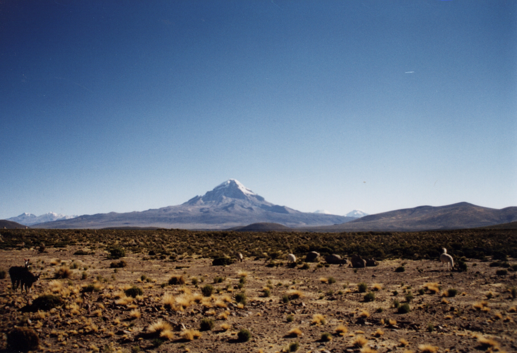
Suri Phuyu ( Aymara ''suri'' rhea, ''phuyu'' feather, "rhea feather", also spelled ''Suriphuyo'') is a mountain in the Cordillera Occidental range of the Bolivian Andes. It is located in the Potosí Department, Sur Lípez Province, San Pablo de Lípez Municipality. Suri Phuyu lies within the borders of the Eduardo Avaroa Andean Fauna National Reserve. Reserva National de Fauna Andina Eduardo Avaroa It is situated southwest of the Uturunku
Uturuncu is a dormant volcano in the Sur Lípez Province of Bolivia. It is high, has two summit peaks, and consists of a complex of lava domes and lava flows with a total volume estimated to be . It bears traces of a ...
[...More Info...] [...Related Items...] OR: [Wikipedia] [Google] [Baidu] |
Bolivia
, image_flag = Bandera de Bolivia (Estado).svg , flag_alt = Horizontal tricolor (red, yellow, and green from top to bottom) with the coat of arms of Bolivia in the center , flag_alt2 = 7 × 7 square patchwork with the (top left to bottom right) diagonals forming colored stripes (green, blue, purple, red, orange, yellow, white, green, blue, purple, red, orange, yellow, from top right to bottom left) , other_symbol = , other_symbol_type = Dual flag: , image_coat = Escudo de Bolivia.svg , national_anthem = " National Anthem of Bolivia" , image_map = BOL orthographic.svg , map_width = 220px , alt_map = , image_map2 = , alt_map2 = , map_caption = , capital = La Paz Sucre , largest_city = , official_languages = Spanish , languages_type = Co-official languages , languages ... [...More Info...] [...Related Items...] OR: [Wikipedia] [Google] [Baidu] |
Potosí Department
Potosí (; Aymara language, Aymara: ''Putusi''; qu, P'utuqsi) is a Departments of Bolivia, department in southwestern Bolivia. It comprises 118,218 km2 with 823,517 inhabitants (2012 census). The capital is the city of Potosí. It is mostly a barren, mountainous region with one large plateau to the west, where the largest Salt pan (geology), salt flat in the world, Salar de Uyuni, is located. Cerro Rico, Cerro Potosí was the richest province in the Spanish empire, providing a great percentage of the silver that was Spanish treasure fleet, shipped to Europe. Potosi is also the location of the San Cristóbal mine (Bolivia), San Cristóbal silver, zinc and lead mines, developed by the US-company Apex Silver Mines Limited of Colorado and in November 2008 sold to the Japanese Sumitomo Corporation. Government The chief executive office of Departments of Bolivia, Bolivia departments (since May 2010) is the governor; until then, the office was called the prefect, and until 2006 ... [...More Info...] [...Related Items...] OR: [Wikipedia] [Google] [Baidu] |
Sur Lípez Province
Sur Lípez or Sud Lípez is a province in the Potosí Department in Bolivia. The seat of the province is San Pablo de Lípez. Location Sur Lípez is one of sixteen provinces in the Potosí Department. Also the southwesternmost point of Bolivia is located here, at 22° 49' 41.016" South, 67° 52' 35.004" West, at an elevation of approximately 5,400 m on the northeastern slope of the Licancabur volcano. It is bordered by the Nor Lípez Province in the north and northwest, Enrique Baldivieso Province in the west, the Republic of Chile in the southwest and south, the Republic of Argentina in the southeast and east, and Sud Chichas Province in the northeast. The province extends from the northeast to the southwest, at a length of 230 km and an average width of 100 km. Geography In its southwestern part, the Quetena Grande Canton which lies in the Eduardo Avaroa Andean Fauna National Reserve, the province has a couple of lakes and salt pans, the largest being Laguna Colo ... [...More Info...] [...Related Items...] OR: [Wikipedia] [Google] [Baidu] |
Andes
The Andes, Andes Mountains or Andean Mountains (; ) are the longest continental mountain range in the world, forming a continuous highland along the western edge of South America. The range is long, wide (widest between 18°S – 20°S latitude), and has an average height of about . The Andes extend from north to south through seven South American countries: Venezuela, Colombia, Ecuador, Peru, Bolivia, Chile, and Argentina. Along their length, the Andes are split into several ranges, separated by intermediate depressions. The Andes are the location of several high plateaus—some of which host major cities such as Quito, Bogotá, Cali, Arequipa, Medellín, Bucaramanga, Sucre, Mérida, El Alto and La Paz. The Altiplano plateau is the world's second-highest after the Tibetan plateau. These ranges are in turn grouped into three major divisions based on climate: the Tropical Andes, the Dry Andes, and the Wet Andes. The Andes Mountains are the highest m ... [...More Info...] [...Related Items...] OR: [Wikipedia] [Google] [Baidu] |
Cordillera Occidental, Bolivia
Topographic map of Bolivia showing (east to west) plains of Cordill.html" ;"title="Geology of Bolivia#Lowlands and Sub-Andean zone">Sub-Andean Zone in red, Cordillera Oriental (Bolivia)">Eastern Cordillera in white, Altiplano in gray, and Western Cordillera in white The Cordillera Occidental or Western Cordillera of Bolivia is part of the Andes (that is also part of the American Cordillera), a mountain range characterized by volcanic activity, making up the natural border with Chile and starting in the north with Juqhuri and ending in the south at the Licancabur volcano, which is on the southern limit of Bolivia with Chile. The border goes through the innominated point located at two-thirds of elevation of Licancabur's northeastern slope at the southwestermost point of Bolivia at 22° 49' 41" south and 67° 52' 35" west. The climate of the region is cold and inadequate for animal and plant life. Its main feature is its ground, in which are large quantities of metallic minerals i ... [...More Info...] [...Related Items...] OR: [Wikipedia] [Google] [Baidu] |
Aymara Language
Aymara (; also ) is an Aymaran language spoken by the Aymara people of the Bolivian Andes. It is one of only a handful of Native American languages with over one million speakers.The other native American languages with more than one million speakers are Nahuatl, Quechua languages, and Guaraní. Aymara, along with Spanish and Quechua, is an official language in Bolivia and Peru. It is also spoken, to a much lesser extent, by some communities in northern Chile, where it is a recognized minority language. Some linguists have claimed that Aymara is related to its more widely spoken neighbor, Quechua. That claim, however, is disputed. Although there are indeed similarities, like the nearly identical phonologies, the majority position among linguists today is that the similarities are better explained as areal features rising from prolonged cohabitation, rather than natural genealogical changes that would stem from a common protolanguage. Aymara is an agglutinating and, to a cert ... [...More Info...] [...Related Items...] OR: [Wikipedia] [Google] [Baidu] |
Rhea (bird)
The rheas ( ), also known as ñandus ( ) or South American ostriches, are large ratites (flightless birds without a keel on their sternum bone) in the order Rheiformes, native to South America, distantly related to the ostrich and emu. Most taxonomic authorities recognize two extant species: the greater or American rhea (''Rhea americana''), and the lesser or Darwin's rhea (''Rhea pennata''). The International Union for Conservation of Nature (IUCN) classifies the puna rhea as another species instead of a subspecies of the lesser rhea. The IUCN currently rates the greater and puna rheas as near-threatened in their native ranges, while Darwin's rhea is of least concern. In addition, a feral population of the greater rhea in Germany appears to be growing, though control efforts are underway, and seem to be succeeding in controlling the birds' population growth. Etymology The name "rhea" was used in 1752 by Paul Möhring and adopted as the English common name. Möhring named the ... [...More Info...] [...Related Items...] OR: [Wikipedia] [Google] [Baidu] |
San Pablo De Lípez Municipality
San Pablo de Lípez Municipality is the first municipal section of the Sur Lípez Province in the Potosí Department in Bolivia. Its seat is San Pablo de Lípez. Geography The highest mountain of the municipality is Uturunku at . Other mountains are listed below: Subdivision The municipality consists of the following cantons: * Quetena Grande - 621 inhabitants (''2001'') * San Antonio de Lípez - 505 inhabitants * San Pablo de Lípez - 1,397 inhabitants The people The people are predominantly indigenous citizens of Quechua Quechua may refer to: *Quechua people, several indigenous ethnic groups in South America, especially in Peru *Quechuan languages, a Native South American language family spoken primarily in the Andes, derived from a common ancestral language **So ... descent.obd.descentralizacion.gov.bo/municipal/fichas/ (inactive) References External links San Pablo de Lípez Municipality: population data and map Municipalities of Potosí Department ... [...More Info...] [...Related Items...] OR: [Wikipedia] [Google] [Baidu] |
Eduardo Avaroa Andean Fauna National Reserve
The Eduardo Avaroa Andean Fauna National Reserve (''Reserva Nacional de Fauna Andina Eduardo Avaroa''; Spanish acronym: REA) is located in Sur Lípez Province. Situated in the far southwestern region of Bolivia, it is the country's most visited protected area. It is considered the most important protected area in terms of tourist influx in the Potosí Department. Located at an altitude between and in Bolivia, it extends over an area of and includes the Laguna Colorada National Wildlife Sanctuary. Categorized under IUCN Category IV, it is primarily for the protection of birds that inhabit the different lagoons in the reserve. The reserve protects part of the Central Andean dry puna (oligothermic) ecoregion. The reserve's major attractions are erupting volcanoes, hot springs, geysers, lakes, fumaroles, mountains and its three endemic species of flamingos in particular. History Established in 1973, the national park is named after Eduardo Avaroa (1838–1879), the Bolivian war ... [...More Info...] [...Related Items...] OR: [Wikipedia] [Google] [Baidu] |
Uturunku
Uturuncu is a dormant volcano in the Sur Lípez Province of Bolivia. It is high, has two summit peaks, and consists of a complex of lava domes and lava flows with a total volume estimated to be . It bears traces of a former glaciation, even though it does not currently carry glaciers. Volcanic activity took place during the Pleistocene epoch and the last eruption was 250,000 years ago; since then Uturuncu has not erupted but active fumaroles occur in the summit region, between the two summits. The volcano rises within the Altiplano–Puna volcanic complex, a larger province of large volcanoes and calderas which over the last few million years (mya) have emplaced about of ignimbrites in sometimes very large eruptions. Underneath it lies the so-called Altiplano–Puna magmatic body, a large sill formed by partially molten rocks. Starting in 1992, satellite observations have indicated a large area of regional uplift centered on Uturuncu, which has been interpreted as an i ... [...More Info...] [...Related Items...] OR: [Wikipedia] [Google] [Baidu] |
Salar De Chalviri
Salar de Chalviri, also known as Salar de Ohalviri, is a salt flat in the heart of Eduardo Avaroa Andean Fauna National Reserve, in the Sur Lípez Province, Potosí Department, in southwest Bolivia. It is located at an elevation of approximately .Google Earth elevation for coordinates. Retrieved on May 4, 2012. Salvador Dalí Desert Salvador Dalí Desert ( es, Desierto Salvador Dalí), also known as Dalí Valley (Valle de Dalí), is an extremely barren valley of southwestern Bolivia, in the Potosí Department. It is entirely contained within the borders of Eduardo Avaroa And ... is located to the southwest of the salt flat. References {{Reflist Lakes of Potosí Department Chalviri ... [...More Info...] [...Related Items...] OR: [Wikipedia] [Google] [Baidu] |

.jpg)

.jpg)
