|
Sumsar
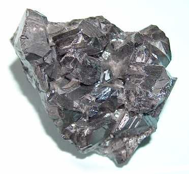
Sumsar is a village in Chatkal District of Jalal-Abad Region of Kyrgyzstan. Its population was 2,802 in 2021. Until 2012 it was an urban-type settlement. It is situated in the foothills of the Chatkal Range. A lead and zinc mine was located in Sumsar. The mine was exploited by the Sumsar company who also operated a uranium mine in neighbouring Shekaftar. The company left behind three huge tailings site containing toxic waste: Most of Tailings No. 1 have slipped into the Sumsar river. Tailings No. 3 have never been covered, leaving a fine dust exposed to the wind. Tailngs No. 2 is also in need of repairs. The mill tailings of the lead and zinc milling in Sumsar and the low-grade uranium ore heaps in Shekaftar need an urgent remedial action because the legacy sites became chronic sources of toxic and radioactive contaminants for the Sumsar-Say River. The legacy sites are approximately 10–15 km upstream from the northern fringes of the Fergana valley that belongs to the most ... [...More Info...] [...Related Items...] OR: [Wikipedia] [Google] [Baidu] |
Chatkal District
Chatkal ( ky, Чаткал району) is a district of Jalal-Abad Region in western Kyrgyzstan. The administrative seat lies at Kanysh-Kyya. Its area is , and its resident population was 28,625 in 2021. Geography The district occupies high-altitude Chatkal valley limited by Talas Ala-Too from north, Pskem Range from north-west and west, and Chatkal Range from south-east. In addition, the district includes a small area of south-east slope of the Chatkal Range facing Fergana Valley. Elevations of the terrain range from approximately 1500 m at Sumsar to 4503 m in the Chatkal range. Some other picks of the district reach altitudes of over 4000 meters. Chatkal valley is pear-shaped. The slope of Chatkal Range facing the valley is terraced. The terraces are dissected by deep canyons of Chatkal river's tributaries, characterized by snowfields and small glaciers in the upstreams. Chandalash Range extends in the central part of the district. Mountains occupy 96%, and vallies - 4% ... [...More Info...] [...Related Items...] OR: [Wikipedia] [Google] [Baidu] |
Shekaftar
Shekaftar ( ky, Шекафтар) is a village in the south of Jalal-Abad Region, Kyrgyzstan. It is part of Chatkal District. Its population was 2,217 in 2021. It lies about from the border with Uzbekistan. A uranium mine was located in Shekaftar between 1946 and 1968; the mine was operated by the Sumsar company from 1958 until its deactivation. In 1997, it was reported that a total of eight radioactive waste Radioactive waste is a type of hazardous waste that contains radioactive material. Radioactive waste is a result of many activities, including nuclear medicine, nuclear research, nuclear power generation, rare-earth mining, and nuclear weapons r ... dumps had been made near Shekaftar. References Populated places in Jalal-Abad Region {{JalalAbad-geo-stub ... [...More Info...] [...Related Items...] OR: [Wikipedia] [Google] [Baidu] |
Kyrgyzstan
Kyrgyzstan,, pronounced or the Kyrgyz Republic, is a landlocked country in Central Asia. Kyrgyzstan is bordered by Kazakhstan to the north, Uzbekistan to the west, Tajikistan to the south, and the People's Republic of China to the east. Its capital and largest city is Bishkek. Ethnic Kyrgyz make up the majority of the country's seven million people, followed by significant minorities of Uzbeks and Russians. The Kyrgyz language is closely related to other Turkic languages. Kyrgyzstan's history spans a variety of cultures and empires. Although geographically isolated by its highly mountainous terrain, Kyrgyzstan has been at the crossroads of several great civilizations as part of the Silk Road along with other commercial routes. Inhabited by a succession of tribes and clans, Kyrgyzstan has periodically fallen under larger domination. Turkic nomads, who trace their ancestry to many Turkic states. It was first established as the Yenisei Kyrgyz Khaganate later in the ... [...More Info...] [...Related Items...] OR: [Wikipedia] [Google] [Baidu] |
Jalal-Abad Region
Jalal-Abad Region ( ky, Жалал-Абад облусу, Jalal-Abad oblusu; russian: Джалал-Абадская область, Dzhalal-Abadskaya oblast) is a region (''oblast'') of Kyrgyzstan. Its capital is the city of the same name, Jalal-Abad. It is surrounded by (clockwise from the north) Talas Region, Chüy Region, Naryn Region, Osh Region, and Uzbekistan. Jalal-Abad Region was established on 21 November 1939. On 27 January 1959 it became a part of Osh Region, but regained its old status as a region on 14 December 1990. Its total area is . The resident population of the region was 1,260,617 as of January 2021. The region has a sizeable Uzbek (24.8% in 2009) minority. Geography Jalal-Abad Region covers (16.2% of total country's area) in central-western Kyrgyzstan. The southern edge of the region is part of the Ferghana Valley. The rest of the region is mountainous. M41, the main north-south highway from Bishkek to Osh, takes a very crooked route down the center o ... [...More Info...] [...Related Items...] OR: [Wikipedia] [Google] [Baidu] |
Urban-type Settlement
Urban-type settlementrussian: посёлок городско́го ти́па, translit=posyolok gorodskogo tipa, abbreviated: russian: п.г.т., translit=p.g.t.; ua, селище міського типу, translit=selyshche mis'koho typu, abbreviated: uk, с.м.т., translit=s.m.t.; be, пасёлак гарадскога тыпу, translit=pasiolak haradskoha typu; pl, osiedle typu miejskiego; bg, селище от градски тип, translit=selishte ot gradski tip; ro, așezare de tip orășenesc. is an official designation for a semi-urban settlement (previously called a "town A town is a human settlement. Towns are generally larger than villages and smaller than cities, though the criteria to distinguish between them vary considerably in different parts of the world. Origin and use The word "town" shares an ori ..."), used in several Eastern European countries. The term was historically used in Bulgaria, Poland, and the Soviet Union, and remains in use ... [...More Info...] [...Related Items...] OR: [Wikipedia] [Google] [Baidu] |
Chatkal Range
Chatkal Range is a range in the Western Tian Shan that borders Ferghana Valley from northwest. The length of the range is 225 km, and it is up to 30 km wide. The highest peak is Avletim (4503 m elevation). Northern slopes are steep and short, while southern ones are gentle. The range is composed by primarily of limestone, granite, and schist Schist ( ) is a medium-grained metamorphic rock showing pronounced schistosity. This means that the rock is composed of mineral grains easily seen with a low-power hand lens, oriented in such a way that the rock is easily split into thin flakes .... References Mountain ranges of Kyrgyzstan Mountain ranges of Uzbekistan Mountain ranges of the Tian Shan {{kyrgyzstan-geo-stub ... [...More Info...] [...Related Items...] OR: [Wikipedia] [Google] [Baidu] |
Lead
Lead is a chemical element with the symbol Pb (from the Latin ) and atomic number 82. It is a heavy metal that is denser than most common materials. Lead is soft and malleable, and also has a relatively low melting point. When freshly cut, lead is a shiny gray with a hint of blue. It tarnishes to a dull gray color when exposed to air. Lead has the highest atomic number of any stable element and three of its isotopes are endpoints of major nuclear decay chains of heavier elements. Lead is toxic, even in small amounts, especially to children. Lead is a relatively unreactive post-transition metal. Its weak metallic character is illustrated by its amphoteric nature; lead and lead oxides react with acids and bases, and it tends to form covalent bonds. Compounds of lead are usually found in the +2 oxidation state rather than the +4 state common with lighter members of the carbon group. Exceptions are mostly limited to organolead compounds. Like the lighter members of the ... [...More Info...] [...Related Items...] OR: [Wikipedia] [Google] [Baidu] |
Zinc
Zinc is a chemical element with the symbol Zn and atomic number 30. Zinc is a slightly brittle metal at room temperature and has a shiny-greyish appearance when oxidation is removed. It is the first element in group 12 (IIB) of the periodic table. In some respects, zinc is chemically similar to magnesium: both elements exhibit only one normal oxidation state (+2), and the Zn2+ and Mg2+ ions are of similar size.The elements are from different metal groups. See periodic table. Zinc is the 24th most abundant element in Earth's crust and has five stable isotopes. The most common zinc ore is sphalerite (zinc blende), a zinc sulfide mineral. The largest workable lodes are in Australia, Asia, and the United States. Zinc is refined by froth flotation of the ore, roasting, and final extraction using electricity ( electrowinning). Zinc is an essential trace element for humans, animals, plants and for microorganisms and is necessary for prenatal and postnatal development. It ... [...More Info...] [...Related Items...] OR: [Wikipedia] [Google] [Baidu] |
Uranium Mine
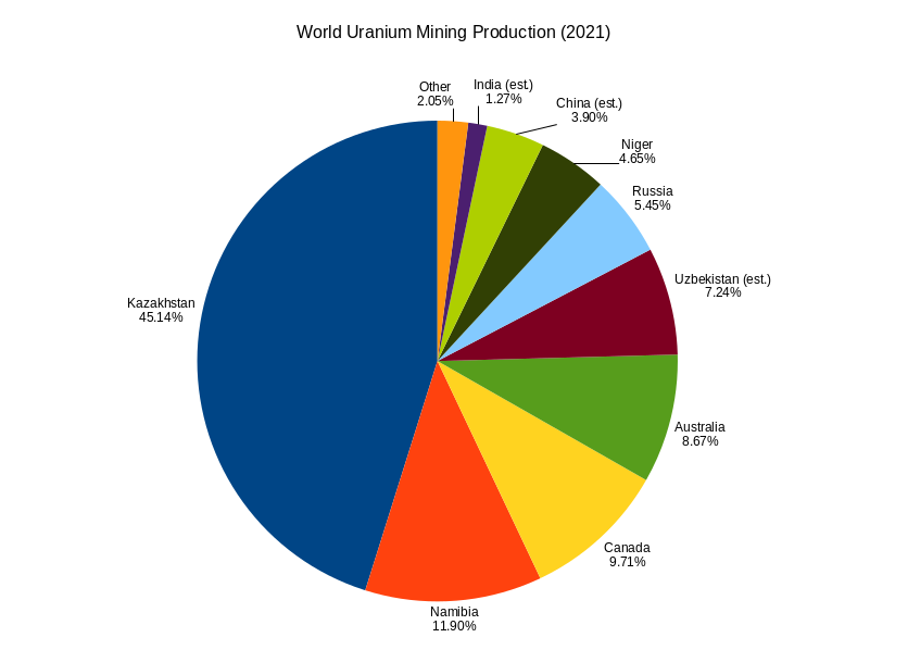
Uranium mining is the process of extraction of uranium ore from the ground. Over 50 thousand tons of uranium were produced in 2019. Kazakhstan, Canada, and Australia were the top three uranium producers, respectively, and together account for 68% of world production. Other countries producing more than 1,000 tons per year included Namibia, Niger, Russia, Uzbekistan, the United States, and China. Nearly all of the world's mined uranium is used to power nuclear power plants. Historically uranium was also used in applications such as uranium glass or ferrouranium but those applications have declined due to the radioactivity of uranium and are nowadays mostly supplied with a plentiful cheap supply of depleted uranium which is also used in uranium ammunition. In addition to being cheaper, depleted uranium is also less radioactive due to a lower content of short-lived and than natural uranium. Uranium is mined by in-situ leaching (57% of world production) or by conventional unde ... [...More Info...] [...Related Items...] OR: [Wikipedia] [Google] [Baidu] |
Tailings
In mining, tailings are the materials left over after the process of separating the valuable fraction from the uneconomic fraction (gangue) of an ore. Tailings are different to overburden, which is the waste rock or other material that overlies an ore or mineral body and is displaced during mining without being processed. The extraction of minerals from ore can be done two ways: placer mining, which uses water and gravity to concentrate the valuable minerals, or hard rock mining, which pulverizes the rock containing the ore and then relies on chemical reactions to concentrate the sought-after material. In the latter, the extraction of minerals from ore requires comminution, i.e., grinding the ore into fine particles to facilitate extraction of the target element(s). Because of this comminution, tailings consist of a slurry of fine particles, ranging from the size of a grain of sand to a few micrometres. Mine tailings are usually produced from the mill in slurry form, which i ... [...More Info...] [...Related Items...] OR: [Wikipedia] [Google] [Baidu] |
Toxic Waste
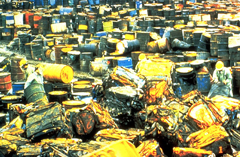
Toxic waste is any unwanted material in all forms that can cause harm (e.g. by being inhaled, swallowed, or absorbed through the skin). Mostly generated by industry, consumer products like televisions, computers, and phones contain toxic chemicals that can pollute the air and contaminate soil and water. Disposing of such waste is a major public health issue. Classifying toxic materials Toxic materials are poisonous byproducts as a result of industries such as manufacturing, farming, construction, automotive, laboratories, and hospitals which may contain heavy metals, radiation, dangerous pathogens, or other toxins. Toxic waste has become more abundant since the industrial revolution, causing serious global issues. Disposing of such waste has become even more critical with the addition of numerous technological advances containing toxic chemical components. Products such as cellular telephones, computers, televisions, and solar panels contain toxic chemicals that can harm th ... [...More Info...] [...Related Items...] OR: [Wikipedia] [Google] [Baidu] |
Fergana Valley
The Fergana Valley (; ; ) in Central Asia lies mainly in eastern Uzbekistan, but also extends into southern Kyrgyzstan and northern Tajikistan. Divided into three republics of the former Soviet Union, the valley is ethnically diverse and in the early 21st century was the scene of conflict. A large triangular valley in what is an often dry part of Central Asia, the Fergana owes its fertility to two rivers, the Naryn River, Naryn and the Kara Darya, which run from the east, joining near Namangan, forming the Syr Darya river. The valley's history stretches back over 2,300 years, when Alexander the Great founded Alexandria Eschate at its southwestern end. Chinese chroniclers date its towns to more than 2,100 years ago, as a path between Greek, Chinese, Bactrian and Parthian civilisations. It was home to Babur, founder of the Mughal Dynasty, tying the region to modern Afghanistan and South Asia. The Russian Empire conquered the valley at the end of the 19th century, and it became part ... [...More Info...] [...Related Items...] OR: [Wikipedia] [Google] [Baidu] |


