|
Staden, Derbyshire
Staden is a small hamlet (of just a few buildings) on the southern outskirts of Buxton, Derbyshire, lying between Harpur Hill and Cowdale. It was occupied in Neolithic, Roman and medieval times. Staden is close to the limestone hilltop of Staden Low whose summit is above sea level. Staden Low prehistoric earthwork is in a field on the western side of Staden Low hill. It is in the form of a slightly raised circular bank (over 50m across) with a smaller adjoining rectangular bank (which is a unique enclosure feature of British henges). Neolithic artefacts were discovered during excavations in 1926 by Mr R. Woolescroft, including a polished stone axe head and many fragments of knapped flint. Further excavations by Dr G. Makepeace in the 1980s uncovered Neolithic pottery sherds and pieces of deer antlers. The finds are on display in Buxton Museum. The site is a protected Scheduled Monument. [...More Info...] [...Related Items...] OR: [Wikipedia] [Google] [Baidu] |
High Peak, Derbyshire
High Peak is a local government district with borough status in Derbyshire, England. The borough compromises high moorland plateau in the Dark Peak area of the Peak District National Park. The district stretches from Holme Moss in the north to Sterndale Moor in the south, and from Hague Bar in the west to Bamford in the east. The population of the borough taken at the 2011 Census was 90,892. The borough is unusual in having two administrative centres for its council, High Peak Borough Council; the offices are based in both Buxton and Glossop. The borough also contains other towns including Chapel-en-le-Frith, Hadfield, New Mills and Whaley Bridge. High Peak was the name of a hundred of the ancient county of Derbyshire covering roughly the same area as the current district. It may have derived its name from the ancient Forest of High Peak, a royal hunting reserve administered by William Peverel, a favourite of William I, who was based at Peak Castle. High Peak contains much ... [...More Info...] [...Related Items...] OR: [Wikipedia] [Google] [Baidu] |
Aquae Arnemetiae
Aquae Arnemetiae was a small town in the Roman province of Britannia. The settlement was based around its natural warm springs. Today it is the town of Buxton, Derbyshire in England. Aquae Arnemetiae means 'Waters of Arnemetia'. Arnemetia was the Romano-British goddess of the sacred grove (the name Arnemetia was derived from the Celtic for beside the sacred grove). The town was recorded as ''Aquis Arnemeza'' in the Ravenna Cosmography's list of all known places in the world in about 700 AD. The entry is between places with which the town had road connections: ''Nauione'' (Navio Roman fort at Brough)'','' ''Zerdotalia'' (Ardotalia, later called Melandra fort, near Glossop) and ''Mantio'' (Manchester). Roman settlement Baths Aquae Arnemetiae and Aquae Sulis (modern town of Bath in Somerset) were the only two Roman bath towns in Britain. The Romans built a bath at the location of the main thermal spring. In the late 17th-century Cornelius White operated bathing facilities ... [...More Info...] [...Related Items...] OR: [Wikipedia] [Google] [Baidu] |
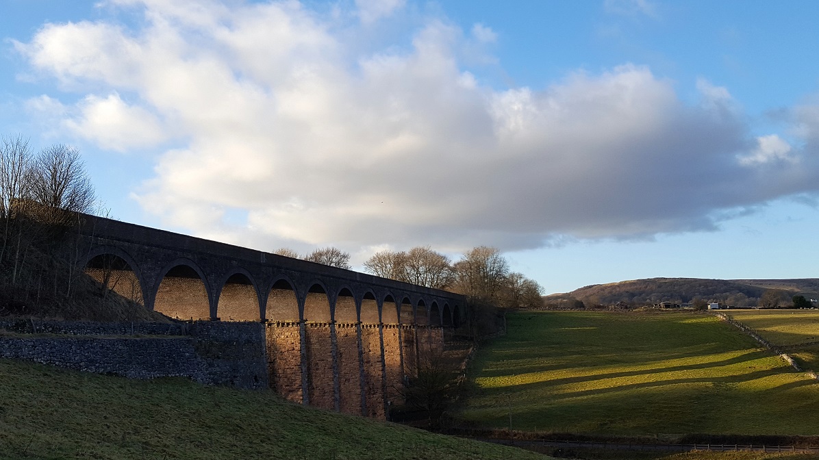
Railway Viaduct From Staden Low
Rail transport (also known as train transport) is a means of transport that transfers passengers and goods on wheeled vehicles running on rails, which are incorporated in tracks. In contrast to road transport, where the vehicles run on a prepared flat surface, rail vehicles (rolling stock) are directionally guided by the tracks on which they run. Tracks usually consist of steel rails, installed on sleepers (ties) set in ballast, on which the rolling stock, usually fitted with metal wheels, moves. Other variations are also possible, such as "slab track", in which the rails are fastened to a concrete foundation resting on a prepared subsurface. Rolling stock in a rail transport system generally encounters lower frictional resistance than rubber-tyred road vehicles, so passenger and freight cars (carriages and wagons) can be coupled into longer trains. The operation is carried out by a railway company, providing transport between train stations or freight customer facili ... [...More Info...] [...Related Items...] OR: [Wikipedia] [Google] [Baidu] |
Peak District Boundary Walk
The Peak District Boundary Walk is a circular walking trail, starting and finishing at Buxton and broadly following the boundary of the Peak District, Britain's first national park. The route was developed by the Friends of the Peak District (a branch of the Campaign to Protect Rural England) and was launched on 17 June 2017. The Friends of the Peak District's founders, Gerald and Ethel Haythornthwaite, proposed the boundary of the Peak District National Park, which was subsequently established as the United Kingdom's first National Park in 1951. The route is waymarked with green markers and uses existing footpaths, tracks, quiet lanes, disused railway lines and a canal towpath. The start and finish is at the King's Head pub on Buxton Market Place, where a plaque has been installed by the Peak & Northern Footpaths Society (PNFS). The terrain covers open moorlands of the South Pennines, the limestone scenery of the Derbyshire Dales, woodlands, reservoirs and rural farming ... [...More Info...] [...Related Items...] OR: [Wikipedia] [Google] [Baidu] |
Midshires Way
The Midshires Way is a long-distance footpath and bridleway that runs for from the Chiltern Hills from near Bledlow in Buckinghamshire, through the Midlands counties of Northamptonshire, Leicestershire, Nottinghamshire and Derbyshire, to Stockport, Greater Manchester. It also links several other long-distance walking routes or trackways including The Ridgeway, the Pennine Bridleway and the Trans Pennine Trail. The route was opened in 1994 as a collaboration between numerous Local Authorities and user groups. It is intended as a multi-user trail but there are places where the recommended route for walkers differs from the route for horse riders and cyclists. Buckinghamshire section The Midshires Way starts from Wain Hill (), between Bledlow and Chinnor. From there it runs near Princes Risborough north to Waddesdon and on to Winslow then in a northwest direction passing through the town of Milton Keynes. North of the town it passes to the west of Stoke Goldington before crossi ... [...More Info...] [...Related Items...] OR: [Wikipedia] [Google] [Baidu] |
A515 Road
The A515 is a primary route in England, which runs from Lichfield in Staffordshire to Buxton in Derbyshire. Route The A515 begins off the A51 road just outside Lichfield. It crosses the Trent and Mersey Canal and passes through the villages of Kings Bromley and Yoxall. As it crosses the River Dove, the road enters Derbyshire. Near Sudbury the road briefly follows the route of the A50 road, before heading northwards again. The road goes through Ashbourne, and shortly afterwards enters the Peak District National Park. It passes through several villages including Fenny Bentley and Newhaven The road terminates in Buxton at its roundabout with the A53 road The A53 is a primary route in the English Midlands, that runs from Buxton in Derbyshire to Shrewsbury in Shropshire. Route of Road The A53 begins in the centre of Buxton off the A6 road, before meeting the A515 road at a roundabout. Out of the .... Future Ashbourne Bypass In 2020, there a consultation occurred propos ... [...More Info...] [...Related Items...] OR: [Wikipedia] [Google] [Baidu] |
Hypocaust
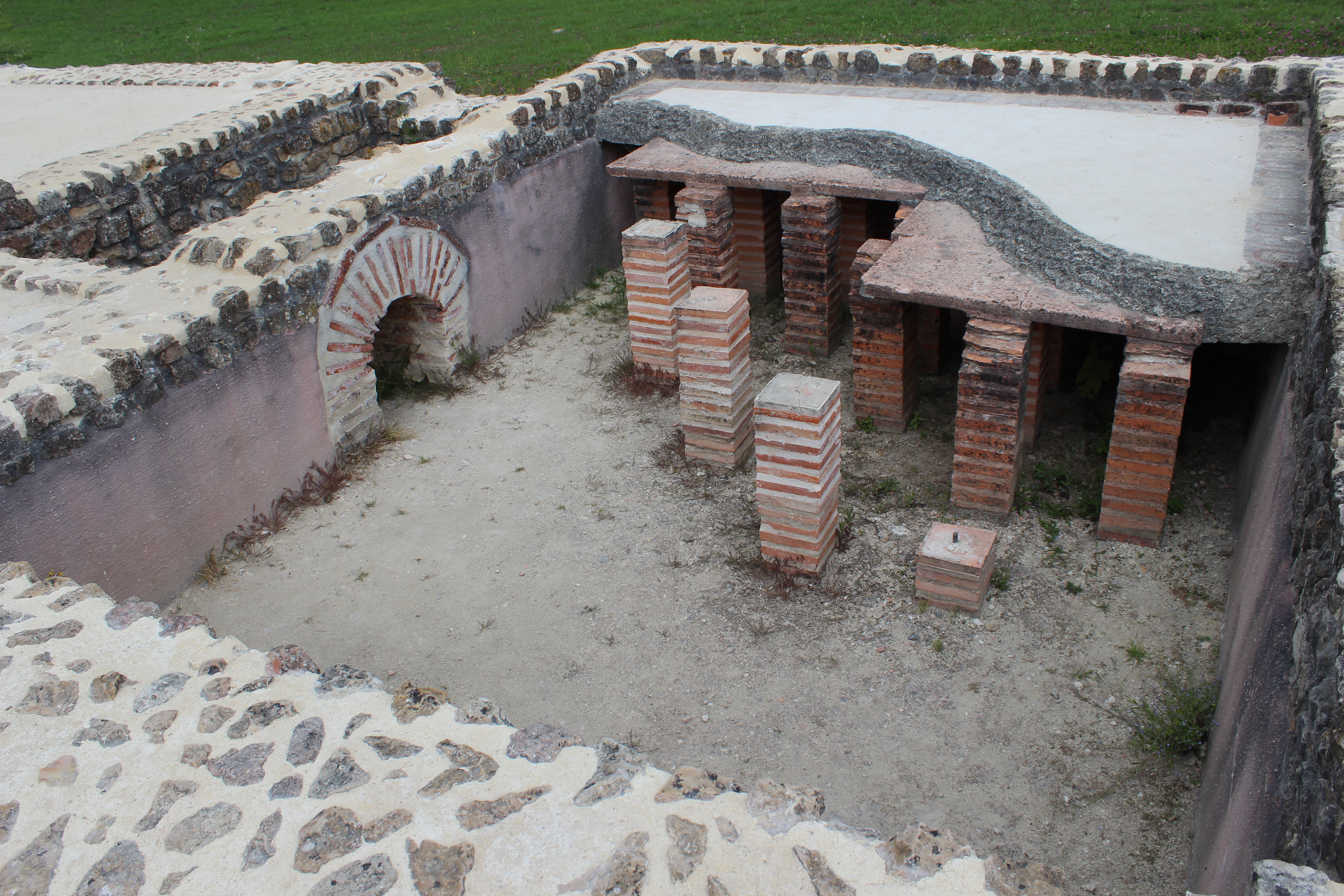
A hypocaust ( la, hypocaustum) is a system of central heating in a building that produces and circulates hot air below the floor of a room, and may also warm the walls with a series of pipes through which the hot air passes. This air can warm the upper floors as well. The word derives from the Ancient Greek meaning "under" and , meaning "burnt" (as in ''caustic''). The earliest reference to such a system suggests that the temple of Ephesus in 350 BC was heated in this manner, although Vitruvius attributes its invention to Sergius Orata in c. 80 BC. Its invention improved the hygiene and living conditions of citizens, and was a forerunner of modern central heating. Roman operation Hypocausts were used for heating hot baths and other public buildings in Ancient Rome. They were also used in private homes. It was a must for the villas of the wealthier merchant class throughout the Roman Empire. The ruins of Roman hypocausts have been found throughout Europe (for example in Ital ... [...More Info...] [...Related Items...] OR: [Wikipedia] [Google] [Baidu] |
Quern-stone
Quern-stones are stone tools for hand-grinding a wide variety of materials. They are used in pairs. The lower stationary stone of early examples is called a saddle quern, while the upper mobile stone is called a muller, rubber or handstone. The upper stone was moved in a back-and-forth motion across the saddle quern. Later querns are known as rotary querns. The central hole of a rotary quern is called the eye, and a dish in the upper surface is known as the hopper. A handle slot contained a handle which enabled the rotary quern to be rotated. They were first used in the Neolithic era to grind cereals into flour. Uses of quern-stones An old Gaelic proverb is "The quern performs best when the grindstone has been pitted." Design of quern-stones The upper stones were usually concave while the lower ones were convex. Quern-stones are frequently identifiable by their grooved working surfaces which enabled the movement of flour. Sometimes a millrind was present as a piece of wood (or o ... [...More Info...] [...Related Items...] OR: [Wikipedia] [Google] [Baidu] |
Environment Agency
The Environment Agency (EA) is a non-departmental public body, established in 1996 and sponsored by the United Kingdom government's Department for Environment, Food and Rural Affairs, with responsibilities relating to the protection and enhancement of the environment in England (and until 2013 also Wales). Based in Bristol, the Environment Agency is responsible for flood management, regulating land and water pollution, and conservation. Roles and responsibilities Purpose The Environment Agency's stated purpose is, "to protect or enhance the environment, taken as a whole" so as to promote "the objective of achieving sustainable development" (taken from the Environment Act 1995, section 4). Protection of the environment relates to threats such as flood and pollution. The vision of the agency is of "a rich, healthy and diverse environment for present and future generations". Scope The Environment Agency's remit covers almost the whole of England, about 13 million h ... [...More Info...] [...Related Items...] OR: [Wikipedia] [Google] [Baidu] |
Derbyshire
Derbyshire ( ) is a ceremonial county in the East Midlands, England. It includes much of the Peak District National Park, the southern end of the Pennine range of hills and part of the National Forest. It borders Greater Manchester to the north-west, West Yorkshire to the north, South Yorkshire to the north-east, Nottinghamshire to the east, Leicestershire to the south-east, Staffordshire to the west and south-west and Cheshire to the west. Kinder Scout, at , is the highest point and Trent Meadows, where the River Trent leaves Derbyshire, the lowest at . The north–south River Derwent is the longest river at . In 2003, the Ordnance Survey named Church Flatts Farm at Coton in the Elms, near Swadlincote, as Britain's furthest point from the sea. Derby is a unitary authority area, but remains part of the ceremonial county. The county was a lot larger than its present coverage, it once extended to the boundaries of the City of Sheffield district in South Yorkshire where it cov ... [...More Info...] [...Related Items...] OR: [Wikipedia] [Google] [Baidu] |
Scheduled Monument
In the United Kingdom, a scheduled monument is a nationally important archaeological site or historic building, given protection against unauthorised change. The various pieces of legislation that legally protect heritage assets from damage and destruction are grouped under the term "designation." The protection provided to scheduled monuments is given under the Ancient Monuments and Archaeological Areas Act 1979, which is a different law from that used for listed buildings (which fall within the town and country planning system). A heritage asset is a part of the historic environment that is valued because of its historic, archaeological, architectural or artistic interest. Only some of these are judged to be important enough to have extra legal protection through designation. There are about 20,000 scheduled monuments in England representing about 37,000 heritage assets. Of the tens of thousands of scheduled monuments in the UK, most are inconspicuous archaeological sites, but ... [...More Info...] [...Related Items...] OR: [Wikipedia] [Google] [Baidu] |
Buxton Museum And Art Gallery
__NOTOC__ Buxton Museum and Art Gallery focuses its collection on history, geology and archaeology primarily from the Peak District and Derbyshire. The museum is located at Terrace Road, Buxton, England. The museum opens Tuesday to Saturday all year round and from Easter to the end of September is also open on Sunday and Bank Holiday afternoons. Admission is free. The building was erected in 1880 and originally served as the Peak Hydropathic Hotel. During the First World War, the Red Cross used it to care for wounded Canadian soldiers. The Buxton Free Public Library & Museum moved into the building in 1928, leaving the Town Hall."Welcome to Buxton Museum & Art Gallery, 2012 pamphlet published by the museum. Permanent collections The museum's permanent collections include: * Carboniferous limestone fossil record of the Peak District collected between 1900 and 1950; * Pliocene mammal evidence from caves and quarries throughout the Peak District; * The archives of archaeologist ... [...More Info...] [...Related Items...] OR: [Wikipedia] [Google] [Baidu] |


_1934.jpg)

