|
South Lampung Regency
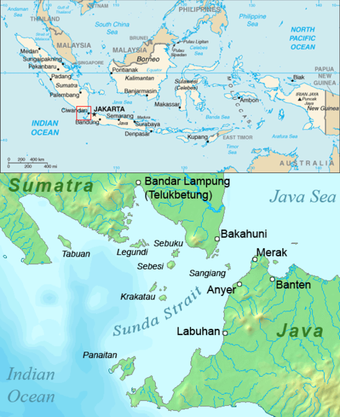
South Lampung Regency ( id, Kabupaten Lampung Selatan) is a regency of Lampung, Sumatra, Indonesia, a strip of land surrounding the provincial capital of Bandar Lampung on its northern and eastern sides, and bounded to the west by the new Pesawaran Regency and to the south by the Sunda Strait; as such it is a major transit corridor to/from Java island. It has an area of 2,245.93 km2, and a population of 909,989 at the 2010 census ) and 1,064,301 at the 2020 census; the official estimate as at mid 2021 was 1,071,727. The regency seat is the town of Kalianda. The regency has seen a population influx as migrants escape the crushing population densities and everyday struggles of living in the massive urban paralysis of Greater Jakarta, and along with Bandar Lampung city its character is increasingly reflecting the cosmopolitan makeup of Jakartans rather than the surrounds of a typical provincial capital and hinterland. This has resulted in flaring of ethnic tensions, including r ... [...More Info...] [...Related Items...] OR: [Wikipedia] [Google] [Baidu] |
List Of Regencies And Cities Of Indonesia
Regencies (''kabupaten'') and cities (''kota'') are the second-level administrative subdivision in Indonesia, immediately below the provinces, and above the districts. Regencies are roughly equivalent to American counties, although most cities in the United States are below the counties. Following the implementation of decentralization beginning on 1 January 2001, regencies and city municipalities became the key administrative units responsible for providing most governmental services. Each of regencies and cities has their own local government and legislative body. The difference between a regency and a city lies in demography, size, and economy. Generally, a regency comprises a rural area larger than a city, but also often includes various towns. A city usually has non-agricultural economic activities. A regency is headed by a regent (''bupati''), while a city is headed by a mayor (''wali kota''). All regents, mayors, and members of legislatures are directly elected via ele ... [...More Info...] [...Related Items...] OR: [Wikipedia] [Google] [Baidu] |
Districts Of Indonesia
The term ''district'', in the context of Indonesia, refers to the third-level Subdivisions of Indonesia, administrative subdivision, below Regency (Indonesia), regency or City status in Indonesia, city. The local term ' is used in the majority of Indonesian areas, except in Papua (province), Papua, West Papua (province), West Papua, and the Special Region of Yogyakarta. The term ' is used in Papua and West Papua. In the Special Region of Yogyakarta, the term ''kapanewon'' is used for districts within the regencies, while the term ' is used for districts within Yogyakarta, the province's only city. According to Statistics Indonesia, there are a total of 7,252 districts in Indonesia as at 2019, subdivided into 83,820 administrative villages (rural ' and urban '). During the Dutch East Indies and early republic period, the term ''district'' referred to ''kewedanan'', a subdivision of regency, while ' was translated as ''subdistrict'' ( nl, onderdistrict). Following the abolition of '' ... [...More Info...] [...Related Items...] OR: [Wikipedia] [Google] [Baidu] |
Tanggamus Regency
Tanggamus Regency is a regency (''kabupaten'') of Lampung Province, Sumatra, Indonesia. It has an area of 4,654.96 km² and had a population of 534,595 at the 2010 Census and 640,275 at the 2020 Census; the official estimate as at mid 2021 was 645,807. The regency seat is the town of Kota Agung Pusat. The regency was created on 21 March 1997, but districts in its eastern part were split away in 2008 to form a new Pringsewu Regency. It lies in the southwest of the province, and surrounds Semangka Bay (''Teluk Semangka'') on its west, north and east coasts. Administrative districts Tanggamus Regency is divided into twenty administrative districts (''kecamatan''), tabulated below with their areas and their populations at the 2010 Census and the 2020 Census, together with the official estimates as at mid 2021. The table also includes the locations of the district administrative centres, the number of villages (rural ''desa'' and urban ''kelurahan'') in each district, and its post ... [...More Info...] [...Related Items...] OR: [Wikipedia] [Google] [Baidu] |
South Sumatra Province
South Sumatra ( id, Sumatra Selatan) is a province of Indonesia. It is located on the southeast of the island of Sumatra, The province spans and had a population of 8,467,432 at the 2020 Census. The capital of the province is Palembang. The province borders the provinces of Jambi to the north, Bengkulu to the west and Lampung to the south. The Bangka Strait in the east separates South Sumatra and the island of Bangka, which is part of the Bangka Belitung Islands province. This province is rich in natural resources, such as petroleum, natural gas and coal. The province is inhabited by many different ethnic groups, with Palembang people the largest ethnic group. Most speak Palembang language, which is mutually unintelligible to both Indonesian and local Malay. Other ethnic groups include the Javanese, Sundanese, Minangkabau and Chinese. Most are concentrated in urban areas and are largely immigrants from other parts of Indonesia. From the 7th century to the late 14th century, ... [...More Info...] [...Related Items...] OR: [Wikipedia] [Google] [Baidu] |
Lampung Province
Lampung (Lampung: ), officially the Province of Lampung ( id, Provinsi Lampung) is a province of Indonesia. It is located on the southern tip of the island of Sumatra. It has a short border with the province of Bengkulu to the northwest, and a longer border with the province of South Sumatra to the north. It is the original home of the Lampung people, who speak their own language, and possess their own written script. Its capital is Bandar Lampung. The province covers a land area of 35,376 sq.km and had a population of 7,608,405 at the 2010 census, 9,007,848 at the 2020 census, and 9,081,792 according to the official estimates for mid 2021,with three-quarters of that being descendants of Javanese, Madurese, and Balinese migrants. These migrants came from more densely populated islands, in search of available land, as well as being part of the national government's Indonesian transmigration program, of which Lampung was one of the earliest and most significant transmigration ... [...More Info...] [...Related Items...] OR: [Wikipedia] [Google] [Baidu] |
West Lampung Regency
West Lampung Regency is a regency of Lampung Province, Sumatra, Indonesia. Until 2012 it had an area of 4,950.4 km2 of which forests occupied some 57% of the total area (as of 2011). It had a population of 418,560 people at the 2010 census. However, on 25 October 2012 the southwestern part of this area was separated from West Lampung Regency to form the new West Pesisir Regency (with its administrative centre at the town of Krui). The residual Lampung Barat Regency now covers an area of 2,116.59 km2 and this area had a population of 277,296 at the 2010 census and 302,139 at the 2020 census; the official estimate as at mid 2021 was 302,750. The regency seat is at the town of Liwa. Administrative Districts West Lampung Regency consisted until 2012 of seventeen districts (''kecamatan''), but the southwestern eight districts were split off in 2012 to form the new Pesisir Barat (''West Coast'') Regency. Since that removal, six new districts have been created within the res ... [...More Info...] [...Related Items...] OR: [Wikipedia] [Google] [Baidu] |
Bandarlampung
Bandar Lampung (Lampung: , ''Kutak Bandarlampung'', formerly Dutch: ''Oosthaven'', lit. "Eastern Harbor") is the capital and largest city of the Indonesian province of Lampung. Located on the southern tip of Sumatra, Bandar Lampung was originally called ''Tanjungkarang–Telukbetung'', since it was a unification of two major settlements in Lampung, before being renamed in 1983. The city proper and South Lampung Regency (which borders the city on its northern and eastern sides) are major transmigrasi recipients; in testimony thereof, it has become the fourth-largest city in the region of Sumatra, after Medan, Palembang and Batam. The city's area is about 197.22 km2, with a census population of 790,057 in 2005, 881,801 in 2010, 977,686 in 2015 and 1,166,066 in 2020. History Bandar Lampung is the capital city of Lampung Province, before it was named Bandar Lampung, this city was named Tanjung Karang-Teluk Betung City. Historically, before becoming Bandar Lampung City, it was ... [...More Info...] [...Related Items...] OR: [Wikipedia] [Google] [Baidu] |
Jakarta Post
''The Jakarta Post'' is a daily English-language newspaper in Indonesia. The paper is owned by PT Niskala Media Tenggara and based in the nation's capital, Jakarta. ''The Jakarta Post'' started as a collaboration between four Indonesian media at the urging of Information Minister Ali Murtopo and politician Jusuf Wanandi. After the first issue was printed on 25 April 1983, it spent several years with minimal advertisements and increasing circulation. After a change in chief editors in 1991, it began to take a more vocal pro-democracy point of view. The paper was one of the few Indonesian English-language dailies to survive the 1997 Asian financial crisis and currently has a circulation of about 40,000. ''The Jakarta Post'' also features an online edition and a weekend magazine supplement called J+. The newspaper is targeted at foreigners and educated Indonesians, although the middle-class Indonesian readership has increased. Noted for being a training ground for local and int ... [...More Info...] [...Related Items...] OR: [Wikipedia] [Google] [Baidu] |
Mount Anak Krakatau
Anak Krakatoa ( id, Anak Krakatau)English translation and common name: ''Child of Krakatoa'' is a volcanic island in Indonesia. On 29 December 1927, Anak Krakatoa first emerged from the caldera formed in 1883 by the explosive volcanic eruption that destroyed the island of Krakatoa. There has been sporadic eruptive activity at the site since the late 20th century, culminating with a large underwater collapse of the volcano that caused a deadly Tsunami in December 2018. There has been subsequent activity since. Due to its young age, the island is one of several in the area that are of interest to, and the subject of extensive study by, volcanologists. History Background After the cataclysmic eruption of Krakatoa in 1883, Krakatoa Island lost approximately two-thirds of its body on the northwest side, obliterating the peaks of Perbuwatan and Danan, and leaving only the southern half of the island, including the Rakata volcano, as the last remnant of the original island. The l ... [...More Info...] [...Related Items...] OR: [Wikipedia] [Google] [Baidu] |
Krakatoa
Krakatoa (), also transcribed (), is a caldera in the Sunda Strait between the islands of Java and Sumatra in the Indonesian province of Lampung. The caldera is part of a volcanic island group (Krakatoa archipelago) comprising four islands. Two, Lang and Verlaten, are remnants of a previous volcanic edifice destroyed in eruptions long before the famous 1883 eruption; another, Rakata, is the remnant of a much larger island destroyed in the 1883 eruption. In 1927, a fourth island, Anak Krakatoa, or "Child of Krakatoa", emerged from the caldera formed in 1883. There has been new eruptive activity since the late 20th century, with a large collapse causing a deadly tsunami in December 2018. Historical significance The most notable eruptions of Krakatoa culminated in a series of massive explosions over 26–27 August 1883, which were among the most violent volcanic events in recorded history. With an estimated Volcanic Explosivity Index (VEI) of 6, the eruption was equivalen ... [...More Info...] [...Related Items...] OR: [Wikipedia] [Google] [Baidu] |
Sebesi
Sebesi (also Sebeezee, or 'Bleezie') is an Indonesian island in the Sunda Strait, between Java and Sumatra, and part of the province of Lampung. It rises to a height of and lies about north of the Krakatoa Archipelago; it is the closest large island to Krakatoa, about the same area and height as the remnant of Rakata. Like Krakatoa, it too is volcanic, although there are no dated eruptions known. (A single report of an eruption in 1680 seems to be a confusion with the Krakatoa eruption reported from that year.) Unlike the Krakatoa Archipelago, Sebesi has permanent streams and is inhabited. Habitation is concentrated most heavily on the northern and eastern coasts of the island. Sebesi was devastated during the 1883 volcanic eruption of Krakatoa. Official records give approximately 3,000 people killed, with 1,000 of these being 'non-residents'. By 1890, Sebesi was being re-cleared. It is believed that since it lies closer to Sumatra, it has served as a 'stepping stone' for muc ... [...More Info...] [...Related Items...] OR: [Wikipedia] [Google] [Baidu] |


