|
South-East Asia Campaign Of Rajendra Chola I
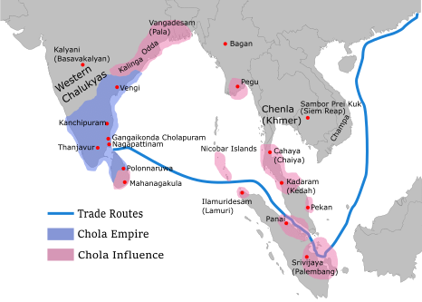
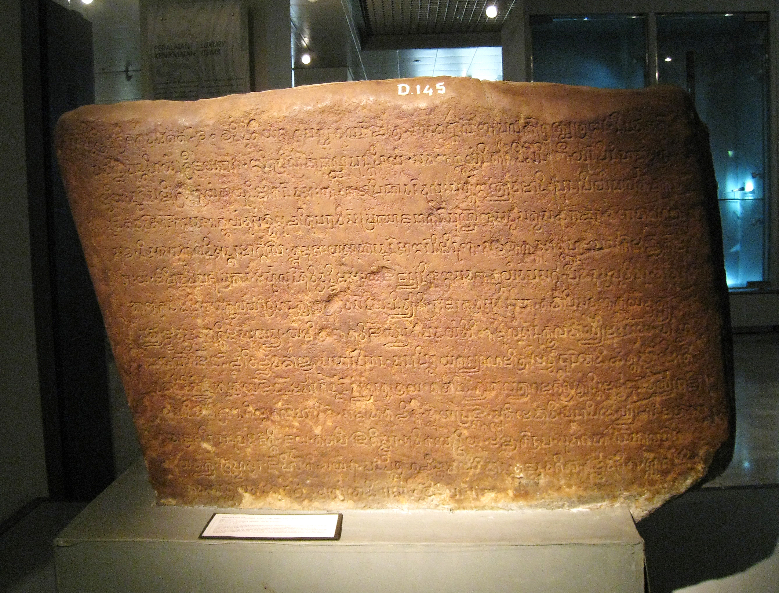
Inscriptions and historical sources assert that the Medieval Cholas, Medieval Chola Emperor Rajendra Chola I sent a naval expedition to Indochina, the Indonesia and Malay Peninsula in 1025 in order to subdue Srivijaya.#Kulke, Kulke, p 212 The Thiruvalangadu plates, the Leyden grant, and the Tamil stele of Rajendra Chola I are the principal sources of information about the campaign. Sources The most detailed source of information on the campaign is the Tamil stele of Rajendra Chola I.#Sastri, Sastri, p 211 The stele states: The Thiruvalangadu plates, from the fourteenth year of Rajendra Chola I, mentions his conquest of Kadaram but does not go into the details. The first attempt by someone from outside India to identify the places associated with the campaign was made by epigraphy, epigraphist E. Hultzsch, who had published the stele in 1891.#Sastri, Sastri, p 212 Hultzsch identified the principalities mentioned in the inscription with places ruled by the Pandyan Dynasty. In 19 ... [...More Info...] [...Related Items...] OR: [Wikipedia] [Google] [Baidu] |
Chola Empire Map2
The Chola dynasty was a Tamils, Tamil thalassocratic Tamil Dynasties, empire of southern India and one of the longest-ruling dynasties in the history of the world. The earliest datable references to the Chola are from inscriptions dated to the 3rd century BCE during the reign of Ashoka of the Maurya Empire. As one of the Three Crowned Kings of Tamilakam, along with the Chera dynasty, Chera and Pandya dynasty, Pandya, the dynasty continued to govern over varying territories until the 13th century CE. The Chola Empire was at its peak under the Medieval Cholas in the mid-9th century CE. The heartland of the Cholas was the fertile valley of the Kaveri River. They ruled a significantly larger area at the height of their power from the later half of the 9th century till the beginning of the 13th century. They unified peninsular India south of the Tungabhadra River, and held the territory as one state for three centuries between 907 and 1215 CE.K. A. Nilakanta Sastri, ''A Histo ... [...More Info...] [...Related Items...] OR: [Wikipedia] [Google] [Baidu] |
Maravijayattungavarman
Sri Maravijayottunggavarman was a king of Srivijaya Kingdom of Shailendra dynasty, who reigned between 1008-c.1025 CE. He was the son of King Sri Chudamanivarmadeva. He was called ''Se-li-ma-la-pi'' in the Chinese chronicle. Biography Maravijayottunggavarman started his reign around 1008 CE, when he was recorded to have sent three envoys to the emperor of China. Srivijaya was also in a good relationship with the Chola Empire, which at that time was under King Rajaraja I. The Leiden Inscription (1044 CE) mentions that Maravijayottunggavarman even built a Buddhist vihara known as Chudamani Vihara at Nagapattinam, dedicated to his late father's name. Chinese sources also speak of a major warfare between his kingdom and the Kingdom of Mataram of East Java. In 1016 CE, Srivijaya may be assisting a rebellious vassal state of Mataram, causing the death of King Dharmavangsa Teguh Anantavikrama and the destruction of Mataram Kingdom. See also * Srivijaya * Chudamani Vihara Chudamani ... [...More Info...] [...Related Items...] OR: [Wikipedia] [Google] [Baidu] |
Melayu Kingdom
The Melayu Kingdom (also known as Malayu, Dharmasraya Kingdom or the Jambi Kingdom; , reconstructed Middle Chinese pronunciation ''mat-la-yu kwok'')Muljana, Slamet , (2006), ''Sriwijaya'', Yogyakarta: LKIS, . was a classical Buddhist kingdom located in Southeast Asia. The primary sources for much of the information on the kingdom are the '' New History of the Tang'', and the memoirs of the Chinese Buddhist monk Yijing who visited in 671, and the state was "absorbed" by Srivijaya by 692, but had "broken away" by the end of the twelfth century according to Chao Jukua. The exact location of the kingdom is the subject of studies among historians. One theory is that the kingdom was established around present-day Jambi on Sumatra, Indonesia, approximately 300 km north of Palembang. According to this theory, it was founded by ethnic groups in the Batanghari river area and gold traders from the Minangkabau hinterland of Pagarruyung. Etymology There are different proposals for ... [...More Info...] [...Related Items...] OR: [Wikipedia] [Google] [Baidu] |
Barumun River
Barumun River is a Sumatran river that begins in Siraisan, Padang Lawas Regency in the southeastern North Sumatra, Indonesia, about 1200 km northwest of the capital Jakarta. at Geonames.org (cc-by); Last updated 2013-06-04; Database dump downloaded 2015-11-27 Hydrology The river flows northward through North Padang Lawas, and before it reaches Sumatra east coast with its estuary in ...[...More Info...] [...Related Items...] OR: [Wikipedia] [Google] [Baidu] |
North Sumatra
North Sumatra ( id, Sumatra Utara) is a province of Indonesia located on the northern part of the island of Sumatra. Its capital and largest city is Medan. North Sumatra is Indonesia's fourth most populous province after West Java, East Java and Central Java, and also the most populous in the island of Sumatra. It covers an area of 72,981 km2. According to the 2020 census, the province's population in that year was 14,799,361. The mid-2021 official estimate is 14,936,148. North Sumatra is a multi-ethnic province. The Malay people are regarded as the natives of the east coast of the province, while the west coast of the province is mainly inhabited by the Batak (''Pakpak'', ''Angkola'' and ''Mandailing'' groups). The central highlands region around Lake Toba is predominantly inhabited by another ''Batak'' groups (''Toba'', ''Simalungun'' and ''Karo''). The Nias people are natives to ''Nias Island'' and its surrounding islets. With the opening of tobacco plantations in East S ... [...More Info...] [...Related Items...] OR: [Wikipedia] [Google] [Baidu] |
Pannai
Pannai, Panai or Pane was a Buddhist kingdom located on the east coast of Northern Sumatra that existed between the 11th and 14th centuries. The kingdom was located on the Barumun River and Panai River valleys, in today's Labuhan Batu and South Tapanuli regencies. Because surviving inscriptions and historical records of this period are scarce, the kingdom is among the least known political entities in Indonesian history. Historians suggest that Pannai was probably a principality or a vassal allied under the Srivijayan mandala and later to Dharmasraya kingdom. The historical records mentioning this kingdom derived from Indian and Javanese sources. The state of Pannai, with river runs through it, was mentioned in the Tanjore inscription dating from the 11th century, as one of the polity sacked by Rajendra Chola I of Chola dynasty during his campaign against the prosperous Srivijaya. Three centuries later, Prapanca confirmed Pannai as one of the Malay states targeted in Majapahit' ... [...More Info...] [...Related Items...] OR: [Wikipedia] [Google] [Baidu] |
South Sumatra
South Sumatra ( id, Sumatra Selatan) is a province of Indonesia. It is located on the southeast of the island of Sumatra, The province spans and had a population of 8,467,432 at the 2020 Census. The capital of the province is Palembang. The province borders the provinces of Jambi to the north, Bengkulu to the west and Lampung to the south. The Bangka Strait in the east separates South Sumatra and the island of Bangka, which is part of the Bangka Belitung Islands province. This province is rich in natural resources, such as petroleum, natural gas and coal. The province is inhabited by many different ethnic groups, with Palembang people the largest ethnic group. Most speak Palembang language, which is mutually unintelligible to both Indonesian and local Malay. Other ethnic groups include the Javanese, Sundanese, Minangkabau and Chinese. Most are concentrated in urban areas and are largely immigrants from other parts of Indonesia. From the 7th century to the late 14th century, ... [...More Info...] [...Related Items...] OR: [Wikipedia] [Google] [Baidu] |
Palembang
Palembang () is the capital city of the Indonesian province of South Sumatra. The city proper covers on both banks of the Musi River on the eastern lowland of southern Sumatra. It had a population of 1,668,848 at the 2020 Census. Palembang is the second most populous city in Sumatra, after Medan, and the ninth most populous city in Indonesia. The Palembang metropolitan area has an estimated population of more than 3.5 million in 2015. It comprises parts of regencies surrounding the city, including Banyuasin, Ogan Ilir, and Ogan Komering Ilir. Palembang is one of the oldest cities in Southeast Asia. It was the capital of Srivijaya, a Buddhist kingdom that ruled much of the western Indonesian Archipelago and controlled many maritime trade routes, including the Strait of Malacca. A Chinese monk, Yijing, wrote that he visited Srivijaya in the year 671 for 6 months. Palembang was incorporated into the Dutch East Indies in 1825 after the abolition of the Palembang Sul ... [...More Info...] [...Related Items...] OR: [Wikipedia] [Google] [Baidu] |
Sri Vijaya
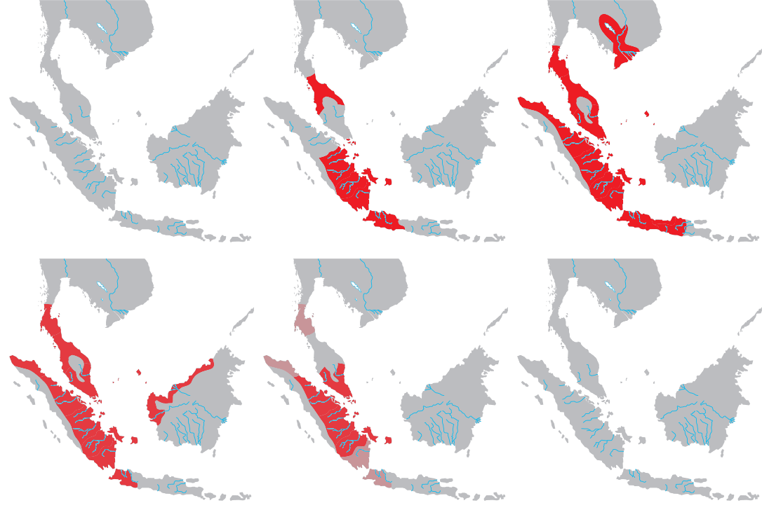
Srivijaya ( id, Sriwijaya) was a Buddhist thalassocratic empire based on the island of Sumatra (in modern-day Indonesia), which influenced much of Southeast Asia. Srivijaya was an important centre for the expansion of Buddhism from the 7th to the 12th century AD. Srivijaya was the first polity to dominate much of western Maritime Southeast Asia. Due to its location, the Srivijaya developed complex technology utilizing maritime resources. In addition, its economy became progressively reliant on the booming trade in the region, thus transforming it into a prestige goods-based economy. The earliest reference to it dates from the 7th century. A Tang dynasty Chinese monk, Yijing, wrote that he visited Srivijaya in year 671 for six months. The earliest known inscription in which the name Srivijaya appears also dates from the 7th century in the Kedukan Bukit inscription found near Palembang, Sumatra, dated 16 June 682. Between the late 7th and early 11th century, Srivijaya rose t ... [...More Info...] [...Related Items...] OR: [Wikipedia] [Google] [Baidu] |
Tambralinga
Tambralinga ( sa, Tāmbraliṅga) was an Indianised kingdom located on the Malay Peninsula, existing at least from the 10th to 13th century. It was under the influence of Srivijaya for some time, but later became independent from it. The name had been forgotten until scholars recognized Tambralinga as Nakhon Si Thammarat (Nagara Sri Dharmaraja). In Sanskrit and Prakrit, ''tām(b)ra'' means "copper", "copper-coloured" or "red" and ''linga'' means "symbol" or "creation", typically representing the divine energy of Shiva. Tambralinga first sent an embassy to China under the Song dynasty in 1001. In the twelfth century it may or may not have been under the suzerainty of the Burmese Pagan Kingdom and Sri Lanka. At its height in the mid-13th century, under King Chandrabhanu, Tambralinga was independent, regrouping and consolidating its power and even invading Sri Lanka. By the end of the 13th century, Tambralinga was recorded in Siamese history as Nakhon Si Thammarat, under the suzera ... [...More Info...] [...Related Items...] OR: [Wikipedia] [Google] [Baidu] |
Chola Dynasty
The Chola dynasty was a Tamils, Tamil thalassocratic Tamil Dynasties, empire of southern India and one of the longest-ruling dynasties in the history of the world. The earliest datable references to the Chola are from inscriptions dated to the 3rd century BCE during the reign of Ashoka of the Maurya Empire. As one of the Three Crowned Kings of Tamilakam, along with the Chera dynasty, Chera and Pandya dynasty, Pandya, the dynasty continued to govern over varying territories until the 13th century CE. The Chola Empire was at its peak under the Medieval Cholas in the mid-9th century CE. The heartland of the Cholas was the fertile valley of the Kaveri River. They ruled a significantly larger area at the height of their power from the later half of the 9th century till the beginning of the 13th century. They unified peninsular India south of the Tungabhadra River, and held the territory as one state for three centuries between 907 and 1215 CE.K. A. Nilakanta Sastri, ''A Histo ... [...More Info...] [...Related Items...] OR: [Wikipedia] [Google] [Baidu] |


.jpg)