|
Soninke People
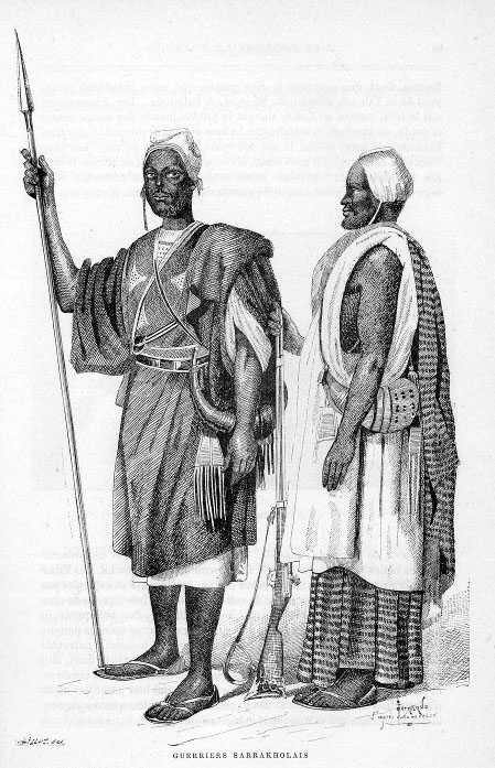
The Soninke people are a West African Mande-speaking ethnic group found in Mali, Fouta Djallon, southern Mauritania, eastern Senegal, Guinea and The Gambia. They speak the Soninke language, also called the Serakhulle or Azer language, which is one of the Mande languages. Soninke people were the founders of the ancient empire of Ghana or Wagadou c. 300–1240 CE, Subgroups of Soninke include the Maraka and Wangara. When the Ghana empire was destroyed, the resulting diaspora brought Soninkes to Mali, Mauritania, Senegal, Gambia, Burkina Faso, Côte d'Ivoire, Guinée-Conakry, modern-day Republic of Ghana, and Guinea-Bissau where some of this trading diaspora was called Wangara. Predominantly Muslims, the Soninke were one of the early ethnic groups from West Africa to convert to Islam in about the 10th century. The contemporary population of Soninke people is estimated to be over 2 million. The cultural practices of Soninke people are similar to the Mandé peoples, and those of ... [...More Info...] [...Related Items...] OR: [Wikipedia] [Google] [Baidu] |
Soninke Language
The Soninke language (Soninke: ''Sooninkanxanne''), also known as Serakhulle or Azer is a Mande languages, Mande language spoken by the Soninke people of Africa. The language has an estimated 2.1 million speakers, primarily located in Mali, and also (in order of numerical importance of the communities) in Senegal, Ivory Coast, The Gambia, Mauritania, Guinea-Bissau, Guinea and Ghana. It enjoys the status of a national language in Mali, Senegal, The Gambia and Mauritania. The language is relatively homogeneous, with only slight phonological, lexical, and grammatical variations. Linguistically, its nearest relatives is the Bozo language , which is centered on the Inner Niger Delta. It is possible that the language of the Imraguen people and/or the Nemadi dialect are dialects of, or closely related to, Soninke. Phonology Consonants Vowels Long vowels are written double: ''aa'', ''ee'', ''ii'', ''oo'', ''uu''. References External linksPanAfriL10n page on Soninke [...More Info...] [...Related Items...] OR: [Wikipedia] [Google] [Baidu] |
Maraka
The Marka (also Marka Dafing, Meka, or Maraka) people are a Mande people of northwest Mali. They speak the Marka language, a Manding language. History Muslim merchant communities at the time of the Bambara Empire, the Maraka largely controlled the desert-side trade between the sahel communities and nomadic berber tribes who crossed the Sahara. The Bambara integrated Maraka communities into their state structure, and Maraka trading posts and plantations multiplied in the Segu based state and its Kaarta vassals in the 18th and early 19th centuries. When the pagan Bambara empire was defeated by the Maraka's fellow Muslim Umar Tall Hadji Oumarûl Foutiyou Tall (Umar ibn Sa'id al-Futi Tal, ar, حاج عمر بن سعيد طعل), ( – 1864 CE), born in Futa Tooro, present day Senegal, was a West African political leader, Islamic scholar, Tijani Sufi and Toucouleur ... in the 1850s, the Maraka's unique trade and landholdings concessions suffered damage from which they ... [...More Info...] [...Related Items...] OR: [Wikipedia] [Google] [Baidu] |
Mopti
Mopti ( Bambara: ߡߏߕߌ tr. Moti) is a town and an urban commune in the Inner Niger Delta region of Mali. The town is the capital of the Mopti Cercle and the Mopti Region. Situated 630 km northeast of Bamako, the town lies at the confluence of the Niger and the Bani Rivers and is linked by an elevated causeway to the town of Sévaré. The urban commune, which includes both Mopti and Sévaré, had a population of 114,296 in the 2009 census. Geography Mopti lies on the right bank of the Bani River, a few hundred meters upstream of the confluence of the Bani with the Niger River. Between August and December when the rivers flood the Inner Niger Delta, the town becomes a series of islands connected by raised causeways. During this period the only road access to the town is along a 12 km causeway that links Mopti to Sévaré. Mopti lies to the west of the Dogon Plateau and is 66 km northwest of Bandiagara and 76 km north-northeast of Djenné. The town is the ca ... [...More Info...] [...Related Items...] OR: [Wikipedia] [Google] [Baidu] |
Ségou
Ségou (; bm, ߛߋߓߎ, italic=no, ) is a town and an urban commune in south-central Mali that lies northeast of Bamako on the right bank of the River Niger. The town is the capital of the Ségou Cercle and the Ségou Region. With 130,690 inhabitants in 2009, it is the fifth-largest town in Mali. The village of Ségou-Koro, upstream of the present town, was established in the 17th century and became the capital of the Bambara Empire. History In the middle of the 19th century there were four villages with the name of Ségou spread out over a distance of around along the right bank of the river. They were, starting from the most upstream, Ségou-Koro (Old Ségou), Ségou-Bougou, Ségou-Koura (New Ségou) and Ségou-Sikoro. The present town is on the site of Ségou-Sikoro. The village of Ségou-Koro prospered after Biton Mamary Coulibaly became king in 1712 and founded the Ségou (or Bamana) Empire. Mungo Park became the first European known to have visited the village ... [...More Info...] [...Related Items...] OR: [Wikipedia] [Google] [Baidu] |
Sikasso
Sikasso ( Bambara: ߛߌߞߊߛߏ tr. Sikaso) is a city in the south of Mali and the capital of the Sikasso Cercle and the Sikasso Region. It is Mali's second largest city with 225,753 residents in the 2009 census. History Sikasso was founded at the beginning of the nineteenth century by Mansa Douala. The town was a small village until 1876 when Tieba Traoré, whose mother came from Sikasso, became King of the Kénédougou Empire and moved its capital there. He established his palace on the sacred Mamelon hill (now home to a water tower) and constructed a ''tata'' or fortifying wall to defend against the attacks of both the Malinke conqueror Samori Ture and the French colonial army. The city withstood a long siege from 1887 to 1888 but fell to the French in 1898. Rather than surrender to the colonial army, Tieba's brother Babemba Traoré, who had succeeded him as king, committed suicide, honoring the famous Bamanankan saying "Saya ka fisa ni maloya ye" (literally: death i ... [...More Info...] [...Related Items...] OR: [Wikipedia] [Google] [Baidu] |
Koulikoro
Koulikoro ( Bambara: ߞߎߟߌߞߏߙߏ tr. Kulikoro) is a town and urban commune in Mali. The capital of the Koulikoro Region, Koulikoro is located on banks of the Niger River, downstream from Mali's capital Bamako. Koulikoro is the terminus of the Dakar-Niger Railway which was completed in 1904. Between August and November, at the end of the rainy season, goods are transported down the Niger River to Ségou, Mopti, Tombouctou and Gao. Navigation is not possible upstream of Koulikoro because of the Sotuba Rapids near Bamako. Koulikoro is also the location of a prison. The Koulikoro prison is noteworthy for housing a number of former Rwandan officers found guilty of having taken part in the Rwandan genocide. Gallery Koulikoro-1898.jpg, Arrival of the Hourst mission, 1898. Hotel de ville de Koulikoro.png, Hotel Koulikoro-Le marché (AOF).jpg, The town's market. Sister cities * Bous, Germany * Quétigny, France France (), officially the French Republic ( ), ... [...More Info...] [...Related Items...] OR: [Wikipedia] [Google] [Baidu] |
Kayes
Kayes (Bambara language, Bambara: ߞߊߦߌ tr. ''Kayi'', Soninke language, Soninké: ''Xaayi'') is a city in western Mali on the Sénégal River with a population of 127,368 at the 2009 census. Kayes is the capital of the Kayes Region, administrative region of the same name. The name "Kayes" comes from the Soninké word "karré", which describes a low humid place that floods in rainy season. The city is located northwest of the capital Bamako. History Prior to French colonial expansion, Kayes was a small village. Its location on the path of the future Dakar-Niger Railway, and the French need for trade centers, led to the creation of the Kayes market town in 1881. It remains a transport hub, primarily for Senegalese trade, to this day. In 1892, Kayes became the capital of the French Sudan; Bamako replaced it as the capital, first of the state of Haut Sénégal-Niger on October 17, 1899, then as the capital of all of French Sudan in 1908. Economy and transport Kayes lies on ... [...More Info...] [...Related Items...] OR: [Wikipedia] [Google] [Baidu] |
Bibliothèque Nationale De France
The Bibliothèque nationale de France (, 'National Library of France'; BnF) is the national library of France, located in Paris on two main sites known respectively as ''Richelieu'' and ''François-Mitterrand''. It is the national repository of all that is published in France. Some of its extensive collections, including books and manuscripts but also precious objects and artworks, are on display at the BnF Museum (formerly known as the ) on the Richelieu site. The National Library of France is a public establishment under the supervision of the Ministry of Culture. Its mission is to constitute collections, especially the copies of works published in France that must, by law, be deposited there, conserve them, and make them available to the public. It produces a reference catalogue, cooperates with other national and international establishments, and participates in research programs. History The National Library of France traces its origin to the royal library founded at t ... [...More Info...] [...Related Items...] OR: [Wikipedia] [Google] [Baidu] |
Imraguen People
The Imraguen, or Imeraguen ( Berber: Imragen), are an ethnic group or tribe of Mauritania and Western Sahara. They were estimated at around 5,000 individuals in the 1970s. Most members of the group live in fishing villages in the Banc d'Arguin National Park, located on the Atlantic coast of Mauritania. History The name ''Imraguen'' (Berber orthography: ''imragen'') is a Berber word meaning "fishermen", or «people who fish while walking on the sea».,Fishermen who "walk on water" burn their nets ''Panda.org'', 5 May 2004 or «those who harvest life». ''Webislam.com'', 17 June 2006 The Imraguen are ... [...More Info...] [...Related Items...] OR: [Wikipedia] [Google] [Baidu] |
Islam
Islam (; ar, ۘالِإسلَام, , ) is an Abrahamic religions, Abrahamic Monotheism#Islam, monotheistic religion centred primarily around the Quran, a religious text considered by Muslims to be the direct word of God in Islam, God (or ''Allah'') as it was revealed to Muhammad, the Muhammad in Islam, main and final Islamic prophet.Peters, F. E. 2009. "Allāh." In , edited by J. L. Esposito. Oxford: Oxford University Press. . (See alsoquick reference) "[T]he Muslims' understanding of Allāh is based...on the Qurʿān's public witness. Allāh is Unique, the Creator, Sovereign, and Judge of mankind. It is Allāh who directs the universe through his direct action on nature and who has guided human history through his prophets, Abraham, with whom he made his covenant, Moses/Moosa, Jesus/Eesa, and Muḥammad, through all of whom he founded his chosen communities, the 'Peoples of the Book.'" It is the Major religious groups, world's second-largest religion behind Christianity, w ... [...More Info...] [...Related Items...] OR: [Wikipedia] [Google] [Baidu] |
Guinea-Bissau
Guinea-Bissau ( ; pt, Guiné-Bissau; ff, italic=no, 𞤘𞤭𞤲𞤫 𞤄𞤭𞤧𞤢𞥄𞤱𞤮, Gine-Bisaawo, script=Adlm; Mandinka: ''Gine-Bisawo''), officially the Republic of Guinea-Bissau ( pt, República da Guiné-Bissau, links=no ), is a country in West Africa that covers with an estimated population of 1,726,000. It borders Senegal to the north and Guinea to the south-east. Guinea-Bissau was once part of the kingdom of Kaabu, as well as part of the Mali Empire. Parts of this kingdom persisted until the 18th century, while a few others were under some rule by the Portuguese Empire since the 16th century. In the 19th century, it was colonised as Portuguese Guinea. Portuguese control was restricted and weak until the early 20th century with the pacification campaigns, these campaigns solidified Portuguese sovereignty in the area. The final Portuguese victory over the remaining bastion of mainland resistance, the Papel ruled Kingdom of Bissau in 1915 by the Portu ... [...More Info...] [...Related Items...] OR: [Wikipedia] [Google] [Baidu] |


.jpg)