|
Smilyan
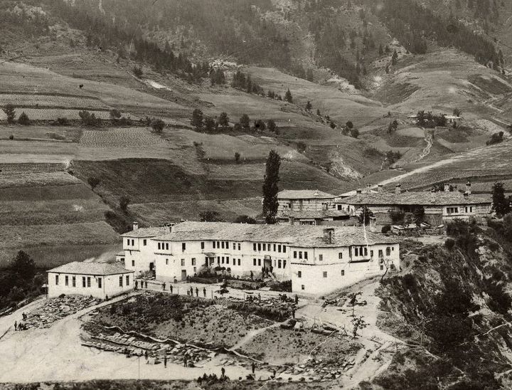
Smilyan (Bulgarian: Смилян) is a village in Smolyan Municipality, located in the Smolyan Province of southern Bulgaria. It is located 176.862 km from Sofia and the village covers an area of 29.248 km2. As of 2019, the village had a population of 1583 people. It is known for its premium quality beans, of which limited quantities are produced. Honours Smilyan Bastion on Loubet Coast, Antarctica Antarctica () is Earth's southernmost and least-populated continent. Situated almost entirely south of the Antarctic Circle and surrounded by the Southern Ocean, it contains the geographic South Pole. Antarctica is the fifth-largest contine ... is named after the village. References Villages in Smolyan Province {{Smolyan-geo-stub ... [...More Info...] [...Related Items...] OR: [Wikipedia] [Google] [Baidu] |
Smilyan Bastion
Smilyan Bastion ( bg, Смилянски рид, ‘Smilyanski Rid’ \'smi-lyan-ski 'rid\) is the rounded ice-covered buttress extending 13 km in southeast-northwest direction and 16 km in south-southwest to north-northeast direction, and rising to 1525 mReference Elevation Model of Antarctica. Polar Geospatial Center. University of Minnesota, 2019 on the west side of on in , |
Smolyan Municipality
Smolyan ( bg, Смолян) List of cities and towns in Bulgaria, is a town and ski resort in the south of Bulgaria near the border with Greece. It is the administrative and industrial centre of the homonymous Smolyan Province. The town is built along the valley of Cherna ("Black") and Byala River, Byala ("White") rivers in the central Rhodope Mountains which makes him the longest city in Bulgaria. It is also located at foot of the mountain's highest peak Golyam Perelik - 2191m. Smolyan is just 10-15 minutes drive from the popular ski resorts Pamporovo and Chepelare. As of June 2022 it has a population of 30 689 inhabitants. Name The name of the town comes from the local Slavic tribe of the Smolyani, the name of whom is probably cognate to the Slavic word ''smola'' ("resin"). History According to archaeological evidence, the area around Smolyan was first settled in the 2nd millennium BC, 2nd-1st millennium BC. In the Middle Ages it acquired its name from the Slavic peoples, Sla ... [...More Info...] [...Related Items...] OR: [Wikipedia] [Google] [Baidu] |
Bulgarian Language
Bulgarian (, ; bg, label=none, български, bălgarski, ) is an Eastern South Slavic language spoken in Southeastern Europe, primarily in Bulgaria. It is the language of the Bulgarians. Along with the closely related Macedonian language (collectively forming the East South Slavic languages), it is a member of the Balkan sprachbund and South Slavic dialect continuum of the Indo-European language family. The two languages have several characteristics that set them apart from all other Slavic languages, including the elimination of case declension, the development of a suffixed definite article, and the lack of a verb infinitive. They retain and have further developed the Proto-Slavic verb system (albeit analytically). One such major development is the innovation of evidential verb forms to encode for the source of information: witnessed, inferred, or reported. It is the official language of Bulgaria, and since 2007 has been among the official languages of the Eur ... [...More Info...] [...Related Items...] OR: [Wikipedia] [Google] [Baidu] |
Bulgaria
Bulgaria (; bg, България, Bǎlgariya), officially the Republic of Bulgaria,, ) is a country in Southeast Europe. It is situated on the eastern flank of the Balkans, and is bordered by Romania to the north, Serbia and North Macedonia to the west, Greece and Turkey to the south, and the Black Sea to the east. Bulgaria covers a territory of , and is the sixteenth-largest country in Europe. Sofia is the nation's capital and largest city; other major cities are Plovdiv, Varna and Burgas. One of the earliest societies in the lands of modern-day Bulgaria was the Neolithic Karanovo culture, which dates back to 6,500 BC. In the 6th to 3rd century BC the region was a battleground for ancient Thracians, Persians, Celts and Macedonians; stability came when the Roman Empire conquered the region in AD 45. After the Roman state splintered, tribal invasions in the region resumed. Around the 6th century, these territories were settled by the early Slavs. The Bulgars, led by Asp ... [...More Info...] [...Related Items...] OR: [Wikipedia] [Google] [Baidu] |
Sofia
Sofia ( ; bg, София, Sofiya, ) is the capital and largest city of Bulgaria. It is situated in the Sofia Valley at the foot of the Vitosha mountain in the western parts of the country. The city is built west of the Iskar river, and has many mineral springs, such as the Sofia Central Mineral Baths. It has a humid continental climate. Being in the centre of the Balkans, it is midway between the Black Sea and the Adriatic Sea, and closest to the Aegean Sea. Known as Serdica in Antiquity and Sredets in the Middle Ages, Sofia has been an area of human habitation since at least 7000 BC. The recorded history of the city begins with the attestation of the conquest of Serdica by the Roman Republic in 29 BC from the Celtic tribe Serdi. During the decline of the Roman Empire, the city was raided by Huns, Visigoths, Avars and Slavs. In 809, Serdica was incorporated into the Bulgarian Empire by Khan Krum and became known as Sredets. In 1018, the Byzantines ended Bulgarian rule ... [...More Info...] [...Related Items...] OR: [Wikipedia] [Google] [Baidu] |
Loubet Coast
Loubet Coast is the portion of the west coast of Graham Land in Antarctic Peninsula, extending 158 km between Cape Bellue to the northeast and Bourgeois Fjord to the southwest. South of Loubet Coast is Fallières Coast, north is Graham Coast. The coast is named after Émile Loubet, President of France during the exploration of the area by the French Antarctic Expedition under Jean-Baptiste Charcot in January 1905. Location Loubet Coast is centred at . UK, British mapping in 1976 - 78. Maps * British Antarctic Territory. Scale 1:200000 topographic map. DOS 610 Series, Sheet W 66 64. Directorate of Overseas Surveys, Tolworth, UK, 1976. * British Antarctic Territory. Scale 1:200000 topographic map. DOS 610 Series, Sheet W 66 66. Directorate of Overseas Surveys, Tolworth, UK, 1976. * British Antarctic Territory. Scale 1:200000 topographic map. DOS 610 Series, Sheet W 67 66. Directorate of Overseas Surveys, Tolworth, UK, 1978. References Composite Antarctic Gazetteer ... [...More Info...] [...Related Items...] OR: [Wikipedia] [Google] [Baidu] |
Antarctica
Antarctica () is Earth's southernmost and least-populated continent. Situated almost entirely south of the Antarctic Circle and surrounded by the Southern Ocean, it contains the geographic South Pole. Antarctica is the fifth-largest continent, being about 40% larger than Europe, and has an area of . Most of Antarctica is covered by the Antarctic ice sheet, with an average thickness of . Antarctica is, on average, the coldest, driest, and windiest of the continents, and it has the highest average elevation. It is mainly a polar desert, with annual precipitation of over along the coast and far less inland. About 70% of the world's freshwater reserves are frozen in Antarctica, which, if melted, would raise global sea levels by almost . Antarctica holds the record for the lowest measured temperature on Earth, . The coastal regions can reach temperatures over in summer. Native species of animals include mites, nematodes, penguins, seals and tardigrades. Where vegetation o ... [...More Info...] [...Related Items...] OR: [Wikipedia] [Google] [Baidu] |


