|
Shigaraki
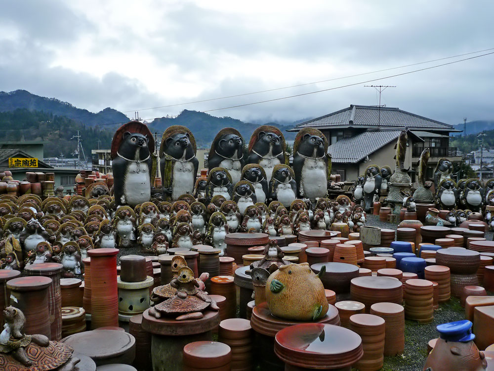
is a town located in Kōka District, Shiga Prefecture, Japan. As of 2004, the town has an estimated population of 13,885 and a density of 84.92 persons per km². The total area is 163.5 km². On October 1, 2004, Shigaraki, along with the towns of Kōka, Kōnan, Minakuchi and Tsuchiyama (all from Kōka District), was merged to create the city of Kōka. It also served as the imperial capital for several months in 745, before moving to Heijō-kyō due to a forest fire destroying the palace (Shigaraki Palace). Shigaraki is famous for its ceramic kilns since ancient times. The area is known for its clay beds, and locally mined clay is often used by local potters. Works produced here are known as Shigaraki-yaki. Many local potters use wood fired anagama kilns. Many tanuki Tanuki may refer to: *Japanese raccoon dog (''Nyctereutes viverrinus'' or ''Nyctereutes procyonoides viverrinus''), a mammal native to Japan *Bake-danuki, a type of spirit (yōkai) in Japanese mythology t ... [...More Info...] [...Related Items...] OR: [Wikipedia] [Google] [Baidu] |
Shigaraki Ware
Shigaraki ware (信楽焼) is a type of stoneware pottery made in Shigaraki area, Japan. The kiln is one of the Six Ancient Kilns in Japan. Although figures representing the tanuki are a popular product included as Shigaraki ware, the kiln and local pottery tradition has a long history. History The development of kilns during the medieval period are thought to have taken place through the transformation of Sue ware technology. In the later half of the Heian period, Sue ware production came to an abrupt decline, with production now centralizing in the Owari, Mino, Bizen, and Omi provinces. Political collapse in the Heian period caused Sue ware potters to begin producing inexpensive wares such as ''tsubo'' (jars), ''kame'' (wide mouthed bowls), and ''suribachi'' (mortars or grinding). The Sue ware workshops began producing in characteristic regional blocks. All these led to the development of kilns in the region known as the ‘Six Old Kilns’. The regional blocks cons ... [...More Info...] [...Related Items...] OR: [Wikipedia] [Google] [Baidu] |
Shigaraki Palace
The was an imperial palace built by Emperor Shōmu, initially as a villa, later named by himself as the capital of Japan in 744 AD. It was located in Kōka District of Ōmi Province in what is now part of the city of Kōka, Shiga Prefecture, Japan. The capital-palace is also referred to as in the ''Shoku Nihongi''. Its ruins were designated a National Historic Site of Japan in 1974. Overview After the rebellion of Fujiwara no Hirotsugu in 740, Emperor Shōmu relocated his seat to (currently part of Kizugawa, Kyoto) and also built a detached villa deep in the mountains of southern Ōmi, which was called "Rakumura". He often visited this villa and in 742 decided to make it his primary residence. There are various theories as to why Emperor Shōmu chose to relocate to such an inconvenient location deep in the mountains. The Kuni area was a power base for Tachibana no Moroe, who was then the minister with de facto power over the " dajō-kan" council. The preference of Shigaraki po ... [...More Info...] [...Related Items...] OR: [Wikipedia] [Google] [Baidu] |
Shigaraki
is a town located in Kōka District, Shiga Prefecture, Japan. As of 2004, the town has an estimated population of 13,885 and a density of 84.92 persons per km². The total area is 163.5 km². On October 1, 2004, Shigaraki, along with the towns of Kōka, Kōnan, Minakuchi and Tsuchiyama (all from Kōka District), was merged to create the city of Kōka. It also served as the imperial capital for several months in 745, before moving to Heijō-kyō due to a forest fire destroying the palace (Shigaraki Palace). Shigaraki is famous for its ceramic kilns since ancient times. The area is known for its clay beds, and locally mined clay is often used by local potters. Works produced here are known as Shigaraki-yaki. Many local potters use wood fired anagama kilns. Many tanuki Tanuki may refer to: *Japanese raccoon dog (''Nyctereutes viverrinus'' or ''Nyctereutes procyonoides viverrinus''), a mammal native to Japan *Bake-danuki, a type of spirit (yōkai) in Japanese mythology t ... [...More Info...] [...Related Items...] OR: [Wikipedia] [Google] [Baidu] |
Kōka, Shiga
280px, Kōka "ninja house" 280px, Shigaraki ware ceramics is a city in southern Shiga Prefecture, Japan. (The word 'Kōka' is often rendered as 'Koga' in English, especially when referring to the "Koga Ninja".) , the city had an estimated population of 89,619 in 36708 households and a population density of 190 persons per km². The total area of the city is . Geography Kōka occupies the entire southern end of Shiga Prefecture, and is thus long east-to-west. At the eastern end of Kōka, the southern ridge of the Suzuka Mountains with one elevation of 1000 meters runs from northeast to southwest, forming the boundary with Mie Prefecture. The highest altitude point in Kōka is Mount Amagoi in this range. Neighboring municipalities Shiga Prefecture *Ōtsu * Rittō * Konan *Higashiōmi *Ryūō * Hino Kyoto Prefecture *Wazuka * Minamiyamashiro *Ujitawara Mie Prefecture *Yokkaichi * Suzuka * Kameyama * Iga *Komono Climate Kōka has a Humid subtropical climate (Köppen ''Cfa'') ... [...More Info...] [...Related Items...] OR: [Wikipedia] [Google] [Baidu] |
Shiga Prefecture
is a prefecture of Japan located in the Kansai region of Honshu. Shiga Prefecture has a population of 1,412,916 (1 October 2015) and has a geographic area of . Shiga Prefecture borders Fukui Prefecture to the north, Gifu Prefecture to the northeast, Mie Prefecture to the southeast, and Kyoto Prefecture to the west. Ōtsu is the capital and largest city of Shiga Prefecture, with other major cities including Kusatsu, Nagahama, and Higashiōmi. Shiga Prefecture encircles Lake Biwa, the largest freshwater lake in Japan, and 37% of the total land area is designated as Natural Parks, the highest of any prefecture. Shiga Prefecture's southern half is located adjacent to the former capital city of Kyoto and forms part of Greater Kyoto, the fourth-largest metropolitan area in Japan. Shiga Prefecture is home to Ōmi beef, the Eight Views of Ōmi, and Hikone Castle, one of four national treasure castles in Japan. History Shiga was known as Ōmi Province or Gōshū before the pref ... [...More Info...] [...Related Items...] OR: [Wikipedia] [Google] [Baidu] |
Kōka District, Shiga
was a district located in Shiga Prefecture, Japan. As of 2003, the district had an estimated population of 147,928 and a density of 267.90 persons per km2. The total area was 552.18 km2. Towns and villages Before the dissolution in 2004, the district had seven towns as listed below. Each municipality is now a part of the city noted in the parentheses. * Ishibe ( Konan) * Kōsei (Konan) * Kōka (Kōka) * Kōnan (Kōka) * Minakuchi (Kōka) * Shigaraki (Kōka) * Tsuchiyama (Kōka) Mergers *On October 1, 2004: ** the towns of Kōsei and Ishibe were merged to create the city of Konan. ** the former town of Kōka absorbed the towns of Kōnan, Minakuchi, Shigaraki and Tsuchiyama to create the city of Kōka was a after ''Tenpō'' and before ''Kaei.'' This period spanned the years from December 1844 through February 1848. The reigning emperors were and . Change of era * December 2, 1844 (): The new era name of ''Kōka'', meaning "Becoming Wide .... Kōka Distr ... [...More Info...] [...Related Items...] OR: [Wikipedia] [Google] [Baidu] |
Anagama Kiln
The ''anagama'' kiln (Japanese Kanji: 穴窯/ Hiragana: あながま) is an ancient type of pottery kiln brought to Japan from China via Korea in the 5th century. It is a version of the climbing dragon kiln of south China, whose further development was also copied, for example in breaking up the firing space into a series of chambers in the ''noborigama'' kiln. An ''anagama'' (a Japanese term meaning "cave kiln") consists of a firing chamber with a firebox at one end and a flue at the other. Although the term "firebox" is used to describe the space for the fire, there is no physical structure separating the stoking space from the pottery space. The term ''anagama'' describes single-chamber kilns built in a sloping tunnel shape. In fact, ancient kilns were sometimes built by digging tunnels into banks of clay. The anagama is fueled with firewood, in contrast to the electric or gas-fueled kilns commonly used by most modern potters. A continuous supply of fuel is needed for f ... [...More Info...] [...Related Items...] OR: [Wikipedia] [Google] [Baidu] |
Tsuchiyama, Shiga
was a town located in Kōka District, Shiga Prefecture, Japan. As of 2004, the town had an estimated population of 9,007 and a density of 71.37 persons per km². The total area is 126.2 km². On October 1, 2004, Tsuchiyama and the towns of Kōka, Kōnan, Minakuchi and Shigaraki (all from Kōka District), were merged to create the city of Kōka. Tsuchiyama is famous for Tsuchiyama-juku, one of the 53 post stations along the Tokaido road and for its production of green tea. Kōka city produces 80% of all green tea in Shiga Prefecture. The sister city of Tsuchiyama is Traverse City, Michigan Michigan () is a state in the Great Lakes region of the upper Midwestern United States. With a population of nearly 10.12 million and an area of nearly , Michigan is the 10th-largest state by population, the 11th-largest by area, and the ..., United States. Climate References External links Koka Sightseeing Guide Kōka, Shiga Dissolved municipalities of Shig ... [...More Info...] [...Related Items...] OR: [Wikipedia] [Google] [Baidu] |
Minakuchi, Shiga
was a town located in Kōka District, Shiga Prefecture, Japan. As of 2004, the town had an estimated population of 38,864 and a density of 563.82 persons per km². The total area was 68.93 km². On October 1, 2004, Minakuchi, along with the towns of Kōka, Kōnan, Shigaraki and Tsuchiyama (all from Kōka District), was merged to create the city of Kōka. In the Edo period, it developed as a post town of Tokaido (Minakuchi-juku) and a castle town for Minakuchi Castle thumbnail, 260px, layout of Minakuchi Castle thumbnail, 260px, Another view of the ''yagura'' , is a ''hirashiro''-style Japanese castle located in the former town of Minakuchi, in the city of Kōka, Shiga Prefecture, Japan. The castle is also .... External links Koka Sightseeing Guide Dissolved municipalities of Shiga Prefecture Kōka, Shiga {{Shiga-geo-stub ... [...More Info...] [...Related Items...] OR: [Wikipedia] [Google] [Baidu] |
Kōnan, Shiga
was a town located in Kōka District, Shiga Prefecture, Japan. "Kōnan" means "southern Kōka". As of 2004, the town has an estimated population of 20,118 and a density of 408.07 persons per km². The total area is 49.3 km². On October 1, 2004, Kōnan, along with the towns of Kōka, Minakuchi, Shigaraki and Tsuchiyama (all from Kōka District), was merged to create the city of Kōka was a after ''Tenpō'' and before ''Kaei.'' This period spanned the years from December 1844 through February 1848. The reigning emperors were and . Change of era * December 2, 1844 (): The new era name of ''Kōka'', meaning "Becoming Wide .... External links Koka Sightseeing Guide Dissolved municipalities of Shiga Prefecture Kōka, Shiga {{shiga-geo-stub ... [...More Info...] [...Related Items...] OR: [Wikipedia] [Google] [Baidu] |
Kōka, Shiga (town)
was a town located in Kōka District, Shiga Prefecture, Japan. As of 2004, the town had an estimated population of 11,630 and a density of 161.89 persons per km². The total area was . On October 1, 2004, Kōka absorbed the towns of Kōnan, Minakuchi, Shigaraki and Tsuchiyama (all from Kōka District) to create the city of Kōka was a after ''Tenpō'' and before ''Kaei.'' This period spanned the years from December 1844 through February 1848. The reigning emperors were and . Change of era * December 2, 1844 (): The new era name of ''Kōka'', meaning "Becoming Wide .... External links Koka Sightseeing Guide Dissolved municipalities of Shiga Prefecture Kōka, Shiga {{shiga-geo-stub ... [...More Info...] [...Related Items...] OR: [Wikipedia] [Google] [Baidu] |
Heijō-kyō
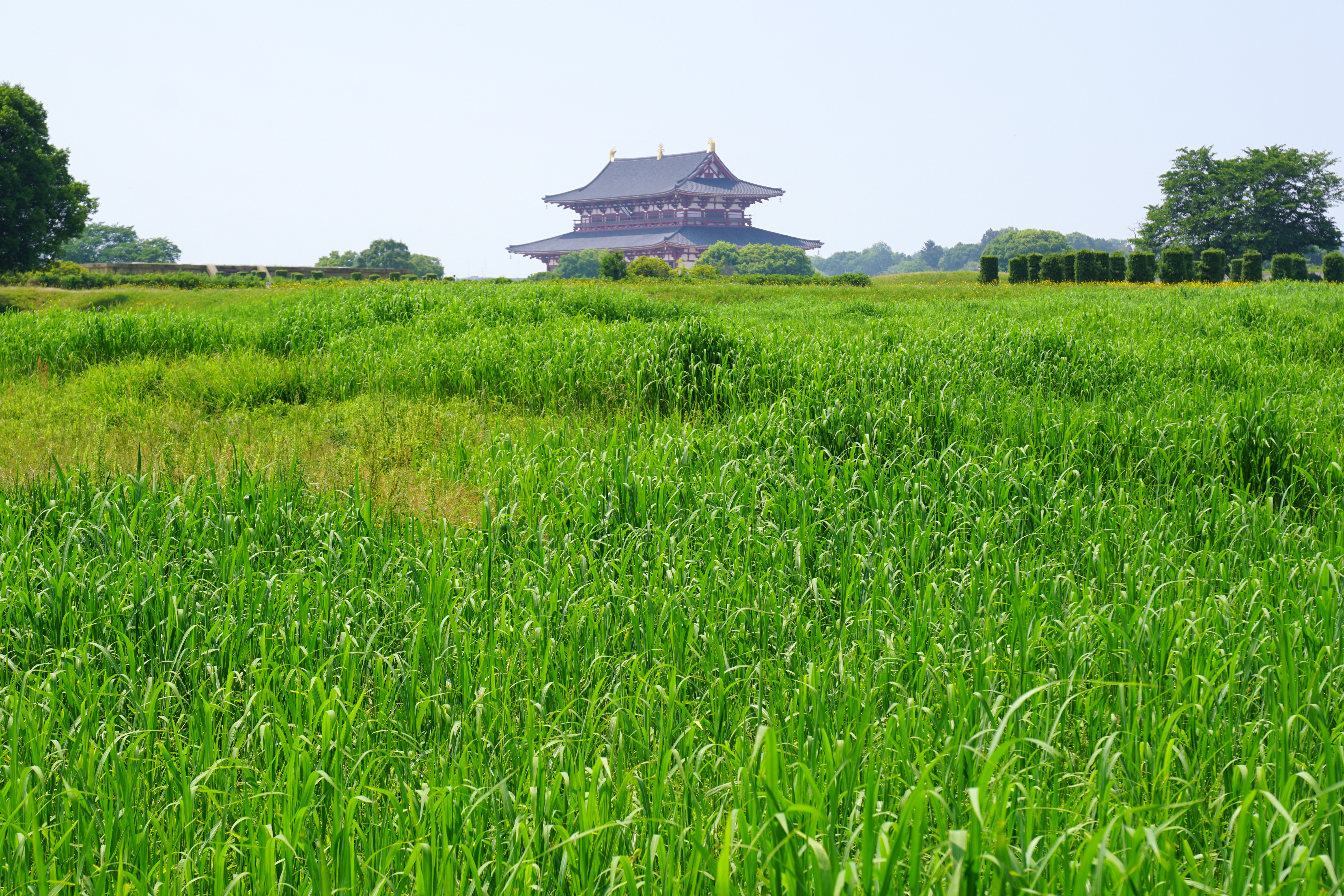
was the Capital of Japan during most of the Nara period, from 710 to 740 and again from 745 to 784. The imperial palace is a listed UNESCO World Heritage together with other places in the city of Nara (cf. Historic Monuments of Ancient Nara). Empress Genmei ordered the Imperial capital moved from Fujiwara-kyō to Heijō-kyō in 708, and the move to Heijō-kyō was complete in 710. Heijō-kyō was modeled after Chang'an, the capital of Tang-dynasty China, although Heijō-kyō lacked walls. In the city, merchants and traders from China, Korea and India introduced various foreign cultures to Heijō-kyō through the Silk Road. As a result, Heijō-kyō flourished as Japan's first international and political capital, with a peak population of between 50,000 and 100,000. The overall form of the city was an irregular rectangle, and the area of city is more than 25 km2. Architecture In the area of Heijō-kyō, there are ancient Buddhist temples, and some temples are also l ... [...More Info...] [...Related Items...] OR: [Wikipedia] [Google] [Baidu] |


