|
Shere
Shere is a village in the Guildford district of Surrey, England east south-east of Guildford and west of Dorking, centrally bypassed by the A25. It is a small still partly agricultural village chiefly set in the wooded 'Vale of Holmesdale' between the North Downs and Greensand Ridge with many traditional English features. It has a central cluster of old village houses, shops including a blacksmith and trekking shop, tea house, art gallery, two pubs and a Norman church. Shere has a CofE infant and nursery school with 'outstanding academic results' (Ofsted 2015) catering for 2- to 7-year-old children which serves the village and surrounding villages and towns, and a museum which opens most afternoons at weekends. The River Tillingbourne runs through the centre of the village. More than four-fifths of homes are in the central area covering ; the northern area of Shere on the North Downs without any named hamlets, including the public hilltop park of Newlands Corner, covers . ... [...More Info...] [...Related Items...] OR: [Wikipedia] [Google] [Baidu] |
Peaslake
Peaslake, Hoe, and Colman's Hill are in the centre of the Surrey Hills AONB and mid-west of the Greensand Ridge about ESE of Guildford. Surrounded by denser pine and other coniferous forest-clad hills, the three conjoined settlements have a small core in Peaslake itself with the amenities of a village, but are otherwise lightly scattered settlements at a higher elevation than the centre of Shere, the civil parish. The area referred to by the 2011 census covers . Friends of the Hurtwood maintains and coppices of surrounding forest, the Hurtwood which comprises: Holmbury Hill, Pitch Hill, Winterfold, Shere Heath, Farley Heath and part of Blackheath Common. It is in the civil parish of Shere. On similar terrain in the far east of the parish and borough is Holmbury St Mary which was used in the 2011 race London-Surrey Cycle Classic – both small villages are centres for hiking and mountain biking. History The earliest mention of Peaslake was in 1784, when Francis Haybitle ... [...More Info...] [...Related Items...] OR: [Wikipedia] [Google] [Baidu] |
Gomshall
Gomshall is a village in the borough of Guildford in Surrey, England.OS Explorer map 145:Guildford and Farnham. Scale: 1:25 000. Publisher:Ordnance Survey – Southampton. It is on the A25, roughly halfway between Guildford and Dorking, and in Shere civil parish, which, reaching to Peaslake and Colmar's Hill, in 2001 recorded a human population of 3,359. Nearest places are Shere, Albury and Abinger Hammer. The River Tillingbourne flows through Gomshall, while the North Downs Way passes just to the north. The village also has a railway station on the North Downs Line, served by Great Western Railway trains running between Reading and Redhill. History The Manor of Gumesele was a Saxon feudal landholding that originally included the present day Gomshall. Gomshall appears in Domesday Book of 1086 as ''Gomeselle''. It was held by William the Conqueror. Its domesday assets were: 1 mill worth 3s 4d, 20 ploughs, of meadow, woodland worth 30 hogs. It rendered £30. In 1154, Hen ... [...More Info...] [...Related Items...] OR: [Wikipedia] [Google] [Baidu] |
River Tillingbourne
The River Tillingbourne (also known as the Tilling Bourne) runs along the south side of the North Downs and joins the River Wey at Guildford. Its source is a mile south of Tilling Springs to the north of Leith Hill at and it runs through Friday Street, Abinger Hammer, Gomshall, Shere, Albury, Chilworth and Shalford. The source is a semi-natural uninhabited area. The catchment is situated on sandstone which has a low rate of weathering. The Tillingbourne is in length. Geography The Tillingbourne initially flows northward for down the northern slopes of Leith Hill over a series of weirs and cascades, before turning west to run for through Abinger Hammer and Chilworth towards the River Wey at Shalford. The river is classified as a subsequent stream, since its course is determined by the direction of the stratum of softer rock for the majority of its length. The river has four principal tributaries: the Friday Street stream joins at Wotton House; the Holmbury St Mary str ... [...More Info...] [...Related Items...] OR: [Wikipedia] [Google] [Baidu] |
Holmbury St Mary
Holmbury St Mary is a village in Surrey, England centered on shallow upper slopes of the Greensand Ridge. Its developed area is a clustered town southwest of Dorking and southeast of Guildford. Most of the village is in the borough of Guildford, within Shere civil parish. Much of the east side of the village street is in the district of Mole Valley, within Abinger civil parish. It contains a building which formerly doubled as a meeting venue for Beatrice Webb, a Fabian social reformer who co-founded the London School of Economics; it is now the location of the Mullard Space Science Laboratory. There is a YHA youth hostel. Geography Holmbury St Mary is located inside the Hurtwood Forest, which is considered the largest area of common land in Surrey; it takes up part of the Greensand Ridge which in turn contributes to the Surrey Hills AONB. Nearby to the south is Holmbury Hill, which at 857 feet (261 m) is the fourth highest point in Surrey. The summit of Holmbury Hill, c ... [...More Info...] [...Related Items...] OR: [Wikipedia] [Google] [Baidu] |
Surrey
Surrey () is a ceremonial and non-metropolitan county in South East England, bordering Greater London to the south west. Surrey has a large rural area, and several significant urban areas which form part of the Greater London Built-up Area. With a population of approximately 1.2 million people, Surrey is the 12th-most populous county in England. The most populated town in Surrey is Woking, followed by Guildford. The county is divided into eleven districts with borough status. Between 1893 and 2020, Surrey County Council was headquartered at County Hall, Kingston-upon-Thames (now part of Greater London) but is now based at Woodhatch Place, Reigate. In the 20th century several alterations were made to Surrey's borders, with territory ceded to Greater London upon its creation and some gained from the abolition of Middlesex. Surrey is bordered by Greater London to the north east, Kent to the east, Berkshire to the north west, West Sussex to the south, East Sussex to ... [...More Info...] [...Related Items...] OR: [Wikipedia] [Google] [Baidu] |
Hundred Of Blackheath, Surrey
Blackheath Hundred or the Hundred of Blackheath was a hundred in the county of Surrey, England. It corresponds to parts of the districts of Waverley and Guildford. Use and significance Though used for entirely secular purposes, it consisted of eleven parishes which in the polity of England from the Norman Conquest until the late 19th century had dual secular and religious functions. Its economic unity was shattered like most hundreds given the rise of smaller manors and newer manors which came to form the main, manageable agricultural asset throughout the country. It occupied approximately the south to south-west twelfth of the county. Its parishes were *Albury *Alfold * Bramley *Cranleigh *Dunsfold * Ewhurst *Hascombe * St Martha * Shalford *Shere *Wonersh History The hundred court meeting place was on the River Wey at a place called Perry Bridge, or La Perie at the western edge of Shalford. The jurisdiction of the sheriff's court was much curtailed by private rights. In ... [...More Info...] [...Related Items...] OR: [Wikipedia] [Google] [Baidu] |
Dorking
Dorking () is a market town in Surrey in South East England, about south of London. It is in Mole Valley District and the council headquarters are to the east of the centre. The High Street runs roughly east–west, parallel to the Pipp Brook and along the northern face of an outcrop of Lower Greensand. The town is surrounded on three sides by the Surrey Hills Area of Outstanding Natural Beauty and is close to Box Hill and Leith Hill. The earliest archaeological evidence of human activity is from the Mesolithic and Neolithic periods, and there are several Bronze Age bowl barrows in the local area. The town may have been the site of a staging post on Stane Street during Roman times, however the name 'Dorking' suggests an Anglo-Saxon origin for the modern settlement. A market is thought to have been held at least weekly since early medieval times and was highly regarded for the poultry traded there. The Dorking breed of domestic chicken is named after the town. The loca ... [...More Info...] [...Related Items...] OR: [Wikipedia] [Google] [Baidu] |
Vale Of Holmesdale
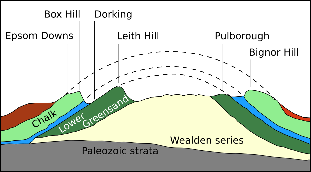
Holmesdale, also known as the Vale of Holmesdale, is a valley in South-East England South East England is one of the nine official regions of England at the first level of ITL for statistical purposes. It consists of the counties of Buckinghamshire, East Sussex, Hampshire, the Isle of Wight, Kent, Oxfordshire, Berkshire, ... that falls between the hill ranges of the North Downs and the Greensand Ridge of the Weald, in the counties of Kent and Surrey. It stretches from Folkestone on the Kent coast, through Ashford, Kent, Ashford, Harrietsham, Maidstone, Riverhead, Kent, Riverhead/Sevenoaks, Westerham, Oxted, Godstone, Redhill, Surrey, Redhill, Reigate, Dorking, Gomshall, and Guildford – west of which it is also called by the local name of "Puttenham Vale" – as it continues through the village of Puttenham, Surrey, Puttenham, to the market town of Farnham. Geology Holmesdale is part of the Weald Basin and Weald–Artois Anticline, Weald-Artois Anticline. The valley ... [...More Info...] [...Related Items...] OR: [Wikipedia] [Google] [Baidu] |
Guildford (district)
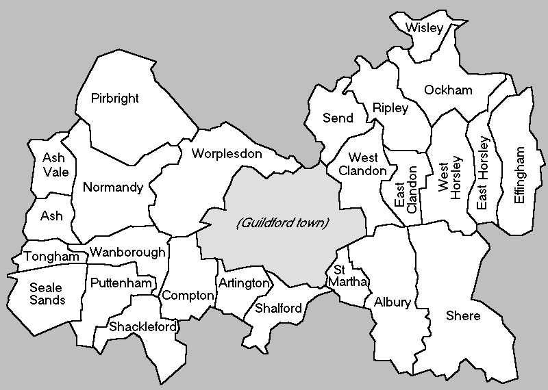
The Borough of Guildford is a local government district with borough status in Surrey, England. With around half of the borough's population, Guildford is its largest settlement and only town, and is the location of the council. The district was formed on 1 April 1974, under the Local Government Act 1972 by an amalgamation of the municipal borough of Guildford and Guildford Rural District. Functions Borough councillors and officers work on devolved issues such as parks, leisure, older residents' services, youth services, streetscene, refuse collection, planning and aspects of business and tourism; Surrey County Council deal with transport, publicly owned infrastructure planning and maintenance, education, social services and overall waste management. The Borough owns significant heritage assets that include monuments such as Guildford Castle, as well museums, art collections and civic regalia. Population Guildford has the second largest population of Surrey's eleven distri ... [...More Info...] [...Related Items...] OR: [Wikipedia] [Google] [Baidu] |
Hundred (county Division)
A hundred is an administrative division that is geographically part of a larger region. It was formerly used in England, Wales, some parts of the United States, Denmark, Southern Schleswig, Sweden, Finland, Norway, the Bishopric of Ösel–Wiek, Curonia, the Ukrainian state of the Cossack Hetmanate and in Cumberland County in the British Colony of New South Wales. It is still used in other places, including in Australia (in South Australia and the Northern Territory). Other terms for the hundred in English and other languages include ''wapentake'', ''herred'' (Danish and Bokmål Norwegian), ''herad'' ( Nynorsk Norwegian), ''hérað'' (Icelandic), ''härad'' or ''hundare'' (Swedish), ''Harde'' (German), ''hiird'' ( North Frisian), ''satakunta'' or ''kihlakunta'' (Finnish), ''kihelkond'' (Estonian), ''kiligunda'' (Livonian), '' cantref'' (Welsh) and ''sotnia'' (Slavic). In Ireland, a similar subdivision of counties is referred to as a barony, and a hundred is a subdivision of a pa ... [...More Info...] [...Related Items...] OR: [Wikipedia] [Google] [Baidu] |
William The Conqueror
William I; ang, WillelmI (Bates ''William the Conqueror'' p. 33– 9 September 1087), usually known as William the Conqueror and sometimes William the Bastard, was the first House of Normandy, Norman List of English monarchs#House of Normandy, king of England, reigning from 1066 until his death in 1087. A descendant of Rollo, he was Duke of Normandy from 1035 onward. By 1060, following a long struggle to establish his throne, his hold on Normandy was secure. In 1066, following the death of Edward the Confessor, William invaded England, leading an army of Normans to victory over the Anglo-Saxons, Anglo-Saxon forces of Harold Godwinson at the Battle of Hastings, and suppressed subsequent English revolts in what has become known as the Norman Conquest. The rest of his life was marked by struggles to consolidate his hold over England and his continental lands, and by difficulties with his eldest son, Robert Curthose. William was the son of the unmarried Duke Robert I of Normandy ... [...More Info...] [...Related Items...] OR: [Wikipedia] [Google] [Baidu] |
Mill (grinding)
A mill is a device, often a structure, machine or kitchen appliance, that breaks solid materials into smaller pieces by grinding, crushing, or cutting. Such comminution is an important unit operation in many processes. There are many different types of mills and many types of materials processed in them. Historically mills were powered by hand or by animals (e.g., via a hand crank), working animal (e.g., horse mill), wind (windmill) or water (watermill). In modern era, they are usually powered by electricity. The grinding of solid materials occurs through mechanical forces that break up the structure by overcoming the interior bonding forces. After the grinding the state of the solid is changed: the grain size, the grain size disposition and the grain shape. Milling also refers to the process of breaking down, separating, sizing, or classifying aggregate material (e.g. mining ore). For instance rock crushing or grinding to produce uniform aggregate size for construction purp ... [...More Info...] [...Related Items...] OR: [Wikipedia] [Google] [Baidu] |


_by_Lewis_Pinhorn_Wood.jpg)
_by_Lewis_Pinhorn_Wood.jpg)


.jpg)
