|
Shell Rock River
The Shell Rock River is a U.S. Geological Survey. National Hydrography Dataset high-resolution flowline dataThe National Map accessed May 13, 2011 tributary of the West Fork Cedar River in southern Minnesota and northern Iowa in the United States. Via the Cedar and Iowa rivers, it is part of the Mississippi River watershed. Name This river was named for the fossil shells found in outcroppings along its banks. The United States Board on Geographic Names settled on "Shell Rock River" as the stream's name in 1931. According to the Geographic Names Information System, it has also been known by the spelling "Shellrock River". Course The Shell Rock River flows from Albert Lea Lake in Freeborn County, Minnesota, and soon enters Iowa, flowing generally south-southeastwardly through eastern Worth, northeastern Cerro Gordo, western Floyd, northeastern Butler, southwestern Bremer and northwestern Black Hawk counties, past the town of Glenville in Minnesota and the towns of Northwood ... [...More Info...] [...Related Items...] OR: [Wikipedia] [Google] [Baidu] |
Minnesota
Minnesota () is a state in the upper midwestern region of the United States. It is the 12th largest U.S. state in area and the 22nd most populous, with over 5.75 million residents. Minnesota is home to western prairies, now given over to intensive agriculture; deciduous forests in the southeast, now partially cleared, farmed, and settled; and the less populated North Woods, used for mining, forestry, and recreation. Roughly a third of the state is covered in forests, and it is known as the "Land of 10,000 Lakes" for having over 14,000 bodies of fresh water of at least ten acres. More than 60% of Minnesotans live in the Minneapolis–Saint Paul metropolitan area, known as the "Twin Cities", the state's main political, economic, and cultural hub. With a population of about 3.7 million, the Twin Cities is the 16th largest metropolitan area in the U.S. Other minor metropolitan and micropolitan statistical areas in the state include Duluth, Mankato, Moorhead, Rochester, and ... [...More Info...] [...Related Items...] OR: [Wikipedia] [Google] [Baidu] |
Drainage Basin
A drainage basin is an area of land where all flowing surface water converges to a single point, such as a river mouth, or flows into another body of water, such as a lake or ocean. A basin is separated from adjacent basins by a perimeter, the '' drainage divide'', made up of a succession of elevated features, such as ridges and hills. A basin may consist of smaller basins that merge at river confluences, forming a hierarchical pattern. Other terms for a drainage basin are catchment area, catchment basin, drainage area, river basin, water basin, and impluvium. In North America, they are commonly called a watershed, though in other English-speaking places, "watershed" is used only in its original sense, that of a drainage divide. In a closed drainage basin, or endorheic basin, the water converges to a single point inside the basin, known as a sink, which may be a permanent lake, a dry lake, or a point where surface water is lost underground. Drainage basins are similar ... [...More Info...] [...Related Items...] OR: [Wikipedia] [Google] [Baidu] |
Cedar Falls, Iowa
Cedar Falls is a city in Black Hawk County, Iowa, United States. As of the 2020 census, the city population was 40,713. It is home to the University of Northern Iowa, a public university. History Cedar Falls was first settled in March 1845 by brothers-in-law William Sturgis and Erasmus D. Adams. Initially, the city was named Sturgis Falls. The city was called Sturgis Falls until it was merged with Cedar City (another city on the other side of the Cedar River), creating Cedar Falls. The city's founders are honored each year with a week long community-wide celebration named in their honor – the Sturgis Falls Celebration. Because of the availability of water power, Cedar Falls developed as a milling and industrial center prior to the Civil War. The establishment of the Civil War Soldiers' Orphans Home in Cedar Falls changed the direction in which the city developed when, following the war, it became the first building on the campus of the Iowa State Normal School (now the Uni ... [...More Info...] [...Related Items...] OR: [Wikipedia] [Google] [Baidu] |
Clarksville, Iowa
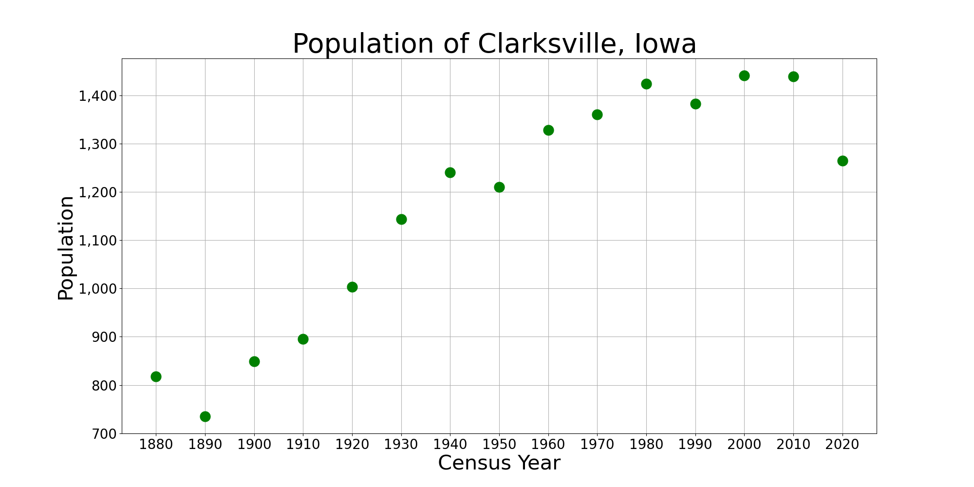
Clarksville is a city in Butler County, Iowa, United States, along the Shell Rock River. The population was 1,264 at the 2020 census. Geography Clarksville is located at 42°46'58" North, 92°40'11" West (42.782665, -92.669842). According to the United States Census Bureau, the city has a total area of , of which is land and is water. Demographics 2010 census As of the census of 2010, there were 1,439 people, 573 households, and 401 families living in the city. The population density was . There were 619 housing units at an average density of . The racial makeup of the city was 98.0% White, 0.1% African American, 0.2% Native American, 0.4% Asian, 0.1% Pacific Islander, 0.1% from other races, and 1.1% from two or more races. Hispanic or Latino of any race were 1.2% of the population. There were 573 households, of which 31.2% had children under the age of 18 living with them, 53.8% were married couples living together, 10.3% had a female householder with no husband present, ... [...More Info...] [...Related Items...] OR: [Wikipedia] [Google] [Baidu] |
Greene, Iowa
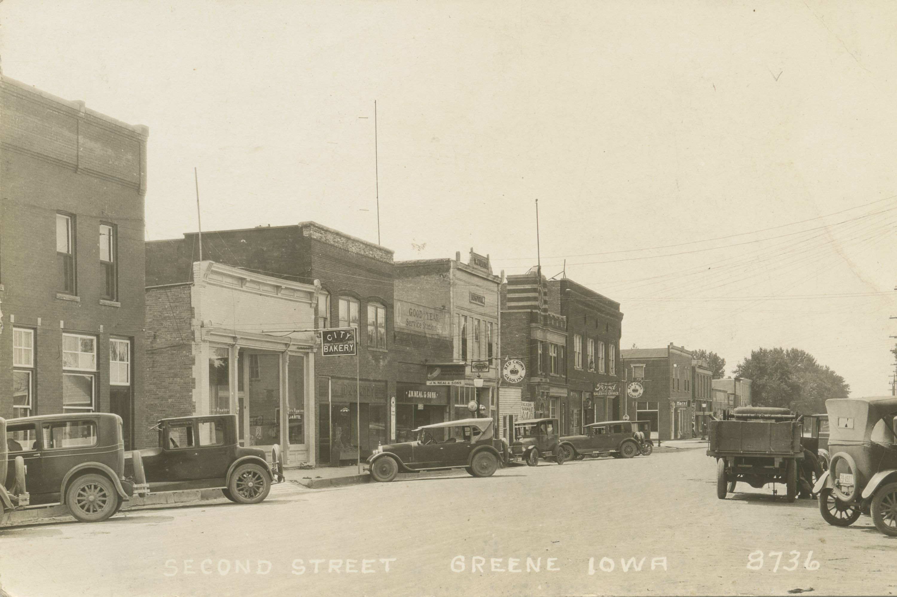
Greene is a city in Butler County, Iowa, United States, along the Shell Rock River, and along Butler County's northern border, where Butler and Floyd counties meet. The population was 990 at the time of the 2020 census. History The community of Greene was first a postal area called, "Elm Springs" that was established in 1855 three miles southwest of the current town on Coldwater Creek. In 1871, the railroad selected a site on the east side of the Shell Rock River for a train depot and roundhouse, drawing the Elm Springs Post Office and community to that site. In 1871, the postal area name was changed from Elm Springs to Greene in honor of Judge George Greene president of the Burlington, Cedar Rapids and Minnesota railroad who, along with J. W. Traer and others, purchased the land for the new community. Judge Greene gave generously of land and money for the new town. In 1879, the Greene postal area was incorporated as The Town of Greene. Geography The city is located along the n ... [...More Info...] [...Related Items...] OR: [Wikipedia] [Google] [Baidu] |
Marble Rock, Iowa
Marble Rock is a city in Floyd County, Iowa, United States, along the Shell Rock River. The population was 271 at the time of the 2020 census. Marble Rock has a city park, historical museums, a powerhouse on the river, and a veterans' memorial. The Marble Rock Historical Society has a website with information about the museums Geography Marble Rock is located at (42.964695, -92.867786). Its name derives from the presence of white limestone in the area. The Shell Rock River runs through the west side of town and is available for fishermen and small watercraft. There is a portage around the dam, on the west side of the river, for canoes. According to the United States Census Bureau, the city has a total area of , of which is land and is water. Demographics 2010 census As of the census of 2010, there were 307 people, 134 households, and 84 families residing in the city. The population density was . There were 150 housing units at an average density of . The racial makeup of th ... [...More Info...] [...Related Items...] OR: [Wikipedia] [Google] [Baidu] |
Rockford, Iowa
Rockford is a city in Floyd County, Iowa, United States, at the confluence of the Shell Rock and Winnebago rivers. The population was 758 at the time of the 2020 census. Geography Rockford's longitude and latitude coordinatesin decimal form are 43.052833, -92.949203. According to the United States Census Bureau, the city has a total area of , all land. Demographics 2010 census As of the census of 2010, there were 860 people, 374 households, and 235 families living in the city. The population density was . There were 417 housing units at an average density of . The racial makeup of the city was 99.1% White, 0.2% African American, 0.1% Native American, 0.1% Asian, and 0.5% from two or more races. Hispanic or Latino of any race were 0.1% of the population. There were 374 households, of which 30.7% had children under the age of 18 living with them, 48.1% were married couples living together, 10.7% had a female householder with no husband present, 4.0% had a male householder w ... [...More Info...] [...Related Items...] OR: [Wikipedia] [Google] [Baidu] |
Nora Springs, Iowa
Nora Springs is a city that is partially in Cerro Gordo County, Iowa, Cerro Gordo and Floyd County, Iowa, Floyd counties in the U.S. state of Iowa, along the Shell Rock River. The population was 1,369 at the time of the 2020 United States Census, 2020 census. The Cerro Gordo County portion of Nora Springs is part of the Mason City, Iowa, Mason City Mason City micropolitan area, Micropolitan Statistical Area. History Nora Springs was founded in 1857 and was incorporated in 1875. It was first called Woodstock, but community pioneer Edson Gaylord, managed to persuade wealthy pioneer Edward Greeley of nearby Woodbridge (later Nashua) to come to town. Greeley agreed to buy and improve the gristmill, and to purchase 20 acres of land from Gaylord, if the town would change its name from Woodstock to Elnora, in honor of a former lady love from Vermont. Gaylord had wanted the town to be named "Springs" and as a result of a compromise, Woodstock became Elnora Springs, quickly shortened t ... [...More Info...] [...Related Items...] OR: [Wikipedia] [Google] [Baidu] |
Rock Falls, Iowa
Rock Falls is a city in Cerro Gordo County, Iowa, United States, along the Shell Rock River. The population was 150 at the time of the 2020 census. It is part of the Mason City Micropolitan Statistical Area. Geography Rock Falls is located at (43.206223, -93.086145). According to the United States Census Bureau, the city has a total area of , all land. Demographics 2010 census As of the census of 2010, there were 155 people, 68 households, and 50 families residing in the city. The population density was . There were 74 housing units at an average density of . The racial makeup of the city was 98.7% White, 0.6% Asian, and 0.6% from two or more races. There were 68 households, of which 22.1% had children under the age of 18 living with them, 66.2% were married couples living together, 4.4% had a female householder with no husband present, 2.9% had a male householder with no wife present, and 26.5% were non-families. 19.1% of all households were made up of individuals, and 10. ... [...More Info...] [...Related Items...] OR: [Wikipedia] [Google] [Baidu] |
Plymouth, Iowa
Plymouth is a city in Cerro Gordo County, Iowa, Cerro Gordo County, Iowa, United States, along the Shell Rock River. The population was 375 at the time of the 2020 United States Census, 2020 census. It is part of the Mason City, Iowa, Mason City Mason City micropolitan area, Micropolitan Statistical Area. Geography Plymouth is located at (43.245346, -93.122575). According to the United States Census Bureau, the city has a total area of , all land. Demographics 2010 census As of the census of 2010, there were 382 people, 164 households, and 111 families residing in the city. The population density was . There were 180 housing units at an average density of . The racial makeup of the city was 97.4% White (U.S. Census), White, 0.5% African American (U.S. Census), African American, 0.3% Native American (U.S. Census), Native American, 0.3% Asian (U.S. Census), Asian, 0.3% Race (U.S. Census), Pacific Islander, and 1.3% from two or more races. Hispanic (U.S. Census), Hispanic or Lati ... [...More Info...] [...Related Items...] OR: [Wikipedia] [Google] [Baidu] |
Northwood, Iowa
Northwood is a city in Worth County, Iowa, United States, along the Shell Rock River. The population was 2,072 at the time of the 2020 census. It is the county seat of Worth County. Northwood is part of the Mason City Micropolitan Statistical Area. History Northwood was laid out in 1857 and platted in 1858. Geography Northwood's longitude and latitude coordinatesin decimal form are 43.445783, -93.219123. According to the United States Census Bureau, the city has a total area of , all land. Demographics 2010 census As of the census of 2010, there were 1,989 people, 885 households, and 530 families living in the city. The population density was . There were 1,004 housing units at an average density of . The racial makeup of the city was 97.3% White, 0.5% African American, 0.2% Native American, 0.1% Asian, 0.9% from other races, and 1.1% from two or more races. Hispanic or Latino of any race were 2.3% of the population. There were 885 households, of which 25.3% had childre ... [...More Info...] [...Related Items...] OR: [Wikipedia] [Google] [Baidu] |
Glenville, Minnesota
Glenville is a city in Freeborn County, Minnesota, Freeborn County, Minnesota, United States, near Albert Lea, Minnesota, Albert Lea. It is along the Shell Rock River. The population was 643 at the 2010 United States Census, 2010 census. History First platted as Shell Rock in 1856, Glenville was then incorporated in 1898. The name Glenville was created by the officers of the railroad company. In 1870 the Burlington, Cedar Rapids, and Northern railroads were run through Glenville. Geography According to the United States Census Bureau, the city has a total area of , of which is land and is water. Glenville is located along U.S. Route 65#Minnesota, U.S. Highway 65 and Freeborn County Road 13. Interstate 35 in Minnesota, I-35 is nearby. Demographics 2010 census As of the census of 2010, there were 643 people, 278 households, and 179 families living in the city. The population density was . There were 290 housing units at an average density of . The racial makeup of the cit ... [...More Info...] [...Related Items...] OR: [Wikipedia] [Google] [Baidu] |


