|
Savincates
The Savincates were a Gallic tribe dwelling in the Ubaye valley, around present-day Faucon-de-Barcelonnette in the Alpes Maritimae, during the Iron Age. Name They are mentioned as ''Savincatium'' on two inscriptions., s.v. ''Savincates''. The meaning of the ethnonym remains obscure. The toponym ''Savines'' has been traditionally compared with ''Savincates'' and associated with their chief town, although this has been criticized by Guy Barruol. Geography The Savincates dwelled south of the Guil valley, in the Ubaye valley, around the town of Rigomagus (modern Faucon-de-Barcelonnette). Their territory was located west of the Veneni, Soti, and Tyrii, south of the Caturiges, east of the Avantici and Adanates, and north of the Gallitae, Eguiturii, and Nemeturii., Map 17: Lugdunum. The '' civitas Rigomagensis'', mentioned in 400 AD in the ''Notitia Galliarum'', extended to all the Ubaye valley. In the 8th–9th centuries, it designated a ''pagus (Rigomagensis)'' or a ' ... [...More Info...] [...Related Items...] OR: [Wikipedia] [Google] [Baidu] |
Caturiges
The Caturiges (Gaulish: ''Caturīges'', 'kings of combat') were a Gallic tribe dwelling in the upper Durance valley, around present-day towns of Chorges and Embrun, during the Iron Age and the Roman period. Name They are mentioned as ''Caturiges'' by Caesar (mid-1st c. BC) and Pliny (1st c. AD), and as ''Katourgídōn'' (Κατουργίδων) by Ptolemy (2nd c. AD). The Gaulish ethnonym ''Caturīges'' (sing. ''Caturix'') literally means 'kings of combat'. It stems from the Celtic root ''catu''- ('combat, battle') attached to ''rīges'' ('kings'). The city of Chorges, attested in the 4th c. AD as ''Caturrigas'' (''Cadorgas'' in 1062, ''Chaorgias'' in 1338), is named after the tribe. Geography Territory The Caturiges dwelled in the upper course of the Durance river. Their territory was located east of the Tricorii, Avantici and Edenates (further west lived the Vocontii), south of the Brigianii and Quariates, west of the Veneni and Soti, and north of the Savincat ... [...More Info...] [...Related Items...] OR: [Wikipedia] [Google] [Baidu] |
Arch Of Augustus (Susa)
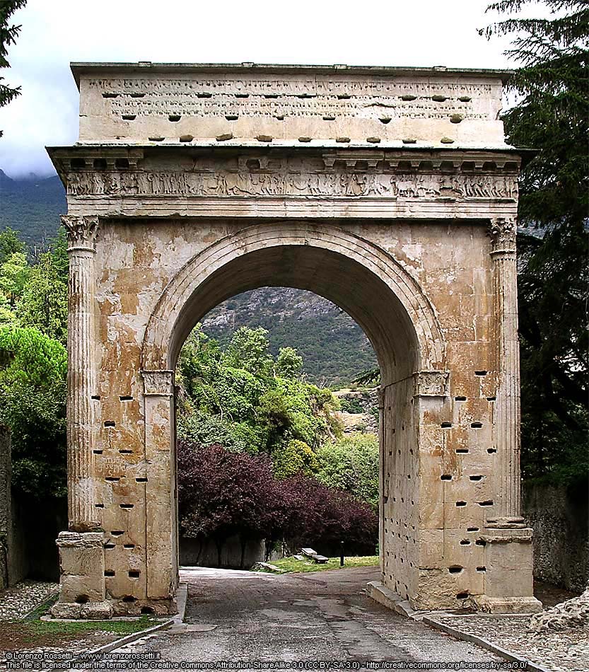
The Arch of Augustus is an important monument constructed in the city of Susa, Piedmont, in the province of Turin. It was originally built at the end of the 1st century BC to record the renewed alliance between Emperor Augustus and Marcus Julius Cottius, a Celto-Ligurian ruler who had been made king and Roman prefect of the Cottian Alps. The arch, together with other remains from the period, such as the Roman amphitheatre and a Roman aqueduct, underscore the importance that the city of Susa had during the Roman period. Description From above, the arch forms a rectangle 11.93 metres long and 7.3 metres wide. It rests on two large bases and there is only one archway. The white marble of the arch was sourced from a nearby quarries at Fornesto and Tre Piloni. The arch has a unique arcade, in which the archivolt is supported by pilasters. The entablature rests on four Corinthian columns placed at the extremities of each corner, such that a quarter of each drum is embedded in the mon ... [...More Info...] [...Related Items...] OR: [Wikipedia] [Google] [Baidu] |
Nemeturii
The Nemeturii (Gaulish *''Nemeturioi'', 'the inhabitants of nemetons') or Nemeturi were a Gallic tribe dwelling in the Alpes Maritimae during the Iron Age. Name They are mentioned as ''Nemeturicae'' by Columella (1st c. AD), and as ''Nemoturica'' and ''Nematuri'' (var. ''nemet''-) by Pliny (1st c. AD)., s.v. ''Nemeturii''. The ethnic name ''Nemeturii'' is a latinized form of Gaulish *''Nemeturioi''. It derives from the stem '' nemeto''-, meaning 'sacred place, sanctuary', and can be translated as 'the inhabitants of sacred places'. Geography The Nemeturii dwelled in the upper Verdon or Var valley. Their territory was located east of the Eguiturii, west of the Ecdinii, north of the Vergunni and Nerusii, and south of the Savincates and Caturiges., Map 16: Col. Forum Iulii-Albingaunum, Map 17: Lugdunum. History They are mentioned by Pliny the Elder as one of the Alpine tribes conquered by Rome in 16–15 BC, and whose name was engraved on the Tropaeum Alpium.Pliny Pliny m ... [...More Info...] [...Related Items...] OR: [Wikipedia] [Google] [Baidu] |
Eguiturii
The Eguiturii or Eguituri were a Celto-Ligurian tribe dwelling in the Alpes Maritimae during the Iron Age. Name They are mentioned as ''Eguituri'' by Pliny (1st c. AD).Pliny. ''Naturalis Historia''3:20 The meaning of the ethnonym ''Eguituri(i)'' remains unclear. The original nominative form was probably ''Eguiturii''. The prefix ''egui''- may be a variant of ''equi''-, which can be translated as 'horse', with an archaic preservation of labio-velar ''-kʷ-'' (in contrast to Gaul. ''epos''). The suffix -''turi(i)'' may be compared with the ethnic name ''Turi'' or ''Turii'' ('' Tyrii''), a tribe living nearby in upper Stura valley. Geography The Eguiturii probably dwelled in the upper Verdon valley. Their territory was located east of the Adanates, Gallitae and Bodiontici, west of the Nemeturii, north of the Sentii and Vergunni, and south of the Savincates and Caturiges., Map 16: Col. Forum Iulii-Albingaunum, Map 17: Lugdunum. History They are mentioned by Pliny the Elder as ... [...More Info...] [...Related Items...] OR: [Wikipedia] [Google] [Baidu] |
Adanates
The Adanates or Edenates were a small Gallic tribe dwelling around present-day Seyne, in the Alpes Cottiae, during the Iron Age. Name They are mentioned as ''Edenates'' (var. '-) by Pliny (1st c. AD),Pliny. ''Naturalis Historia''3:20 and as ''Adanatium'' on the Arc of Susa., s.v. ''Edenates''. The etymology of the name ''Adanates'' is unclear. Guy Barruol has proposed to compare it with ''Adenatius'' (or ''Adenatis'') and ''Adana'', and postulated an original *''Senedenates'', with loss of the initial ''s-'' retained in ''Sedena''. According to Alexander Falileyev, "if the original form was indeed *''Sed-'', the name could be Celtic, from ''sedo-'' 'seat, location'; but in view of the form recorded in inscriptions, it is unlikely. If ''Eden-'' is the original form, the name does not appear Celtic." Xavier Delamarre has proposed to interpret the name as ''Ed-en-ati'' ('those from the land/country'), from a Gaulish stem ''edo-(n)-'' ('space, land'). Geography The Adanates d ... [...More Info...] [...Related Items...] OR: [Wikipedia] [Google] [Baidu] |
Gauls
The Gauls ( la, Galli; grc, Γαλάται, ''Galátai'') were a group of Celtic peoples of mainland Europe in the Iron Age and the Roman period (roughly 5th century BC to 5th century AD). Their homeland was known as Gaul (''Gallia''). They spoke Gaulish, a continental Celtic language. The Gauls emerged around the 5th century BC as bearers of La Tène culture north and west of the Alps. By the 4th century BC, they were spread over much of what is now France, Belgium, Switzerland, Southern Germany, Austria, and the Czech Republic, by virtue of controlling the trade routes along the river systems of the Rhône, Seine, Rhine, and Danube. They reached the peak of their power in the 3rd century BC. During the 4th and 3rd centuries BC, the Gauls expanded into Northern Italy ( Cisalpine Gaul), leading to the Roman–Gallic wars, and into the Balkans, leading to war with the Greeks. These latter Gauls eventually settled in Anatolia, becoming known as Galatians. After the ... [...More Info...] [...Related Items...] OR: [Wikipedia] [Google] [Baidu] |
Cottius
Marcus Julius Cottius was King of the Celtic and Ligurian inhabitants of the mountainous Roman province then known as '' Alpes Taurinae'' and now as the Cottian Alps early in the 1st century BC. Son and successor to King Donnus, he negotiated a dependent status with Emperor Augustus that preserved considerable autonomy for his country, making him a Roman governor, and adopted Roman citizenship. Early relationship with Rome The friendship between Cottius's realm and Rome goes back at least to the reign of his father King Donnus; there is numismatic evidence which suggests that Donnus established friendly relations with Julius Caesar. As Caesar needed to cross the Cottii Regnum in 58 BC on his way to Gaul, he made an agreement with King Donnus to have his troops transported on his road as well as having a new paved road being built.Cornwell, H., Alpine Reactions to Roman Power, in Varga, R., Rusu-Bolindeț, V., (eds) Official Power and Local Elites in the Roman Provinces, p. 59 Thi ... [...More Info...] [...Related Items...] OR: [Wikipedia] [Google] [Baidu] |
Notitia Galliarum
The ''Notitia Galliarum'' (or ''Notitia provinciarum et civitatum Galliae'') is a Roman register of cities dating to the 4th–6th centuries AD., contains the text of the ''Notitia'' with a map. The Latin register is divided into two headings. Ten provinces are listed under the diocese of Gaul and seven under the diocese of the Seven Provinces. For each province the capital city is given and then its other cities (''civitates''). They are given their ethnic names, i.e., "city of eople. A total of 115 cities are listed along with six or seven ''castra'' (forts) and one ''portus'' (harbour). The original list was probably drawn up during the reign of Magnus Maximus (383–388). Its rubric states that it was made on the order of the bishops, but this was probably added later when the list was updated. The ''civitates'' of the ''Notitia'' parallel the dioceses of the Roman church, bur for the 6th rather than the 4th century. It was probably at that time that the ''castra'' and ''por ... [...More Info...] [...Related Items...] OR: [Wikipedia] [Google] [Baidu] |
Civitas
In Ancient Rome, the Latin term (; plural ), according to Cicero in the time of the late Roman Republic, was the social body of the , or citizens, united by law (). It is the law that binds them together, giving them responsibilities () on the one hand and rights of citizenship on the other. The agreement () has a life of its own, creating a or "public entity" (synonymous with ), into which individuals are born or accepted, and from which they die or are ejected. The is not just the collective body of all the citizens, it is the contract binding them all together, because each of them is a . is an abstract formed from . Claude Nicolet traces the first word and concept for the citizen at Rome to the first known instance resulting from the synoecism of Romans and Sabines presented in the legends of the Roman Kingdom. According to Livy, the two peoples participated in a ceremony of union after which they were named Quirites after the Sabine town of Cures. The two groups bec ... [...More Info...] [...Related Items...] OR: [Wikipedia] [Google] [Baidu] |
Gallitae
The Gallitae were a Gallic tribe dwelling in the upper valley of the Bléone river ( Alpes-de-Haute-Provence) during the Iron Age. Name They are mentioned as ''Gallitae'' (var. -''tre'') by Pliny (1st c. AD) and on an inscription.Pliny. ''Naturalis Historia''3:20 CIL 5:7817, s.v. ''Gallitae''. The name ''Gallitae'' appears to be based on the Celtic root ''gal(l)-'', meaning 'power, ability', which can also be found in the ethnic names ''Galli'' (Gauls) and '' Galátai'' (Galatians). Geography The Gallitae lived in the upper valley of the Bléone river, in a land later called ''ager Galadius'' in the early Middle Ages (813–814 AD). Their territory was located north of the Bodiontici, east of the Sogiontii and Sebaginni, west of the Eguiturii, south of the Edenates., Map: 16 Col. Forum Iulii-Albingaunum; Map 17: Lugdunum. History They are mentioned by Pliny the Elder as one of the Alpine tribes conquered by Rome in 16–15 BC, and whose name was engraved on the Tropaeum ... [...More Info...] [...Related Items...] OR: [Wikipedia] [Google] [Baidu] |
Avantici
The Avantici (Gaulish: *''Auanticoi'') were a small Gallic tribe dwelling around present-day Gap, in the western part of the modern Hautes-Alpes department, during the Roman period. Name They are only mentioned once as ''Avanticos'' (var. ''acanticos'', ''aganticos'') by Pliny (1st c. AD).Pliny. ''Naturalis Historia'', 3:37., s.v. ''Avantici''. The Gaulish ethnonym ''Avantici'' is a latinized form of the Gaulish *''Auanticoi'' (sing. ''Auanticos''), deriving from the stem ''auant''- ('source') attached to the adjectival suffix -''ico''-. The stem does not appear to be Celtic. As the hydronymic lexicon is particularly resistant to name changes, the stem ''auant''- is probably a term of pre-Celtic Indo-European origin (cf. Latv. ''avuots'' 'source', Skr. ''avatá''- 'well, cistern'), which eventually came to be adopted by the Celts; the latter may have made use of it in proper names only. Geography Territory The territory of the Avantici roughly corresponded to the later ... [...More Info...] [...Related Items...] OR: [Wikipedia] [Google] [Baidu] |


