|
Sarankot
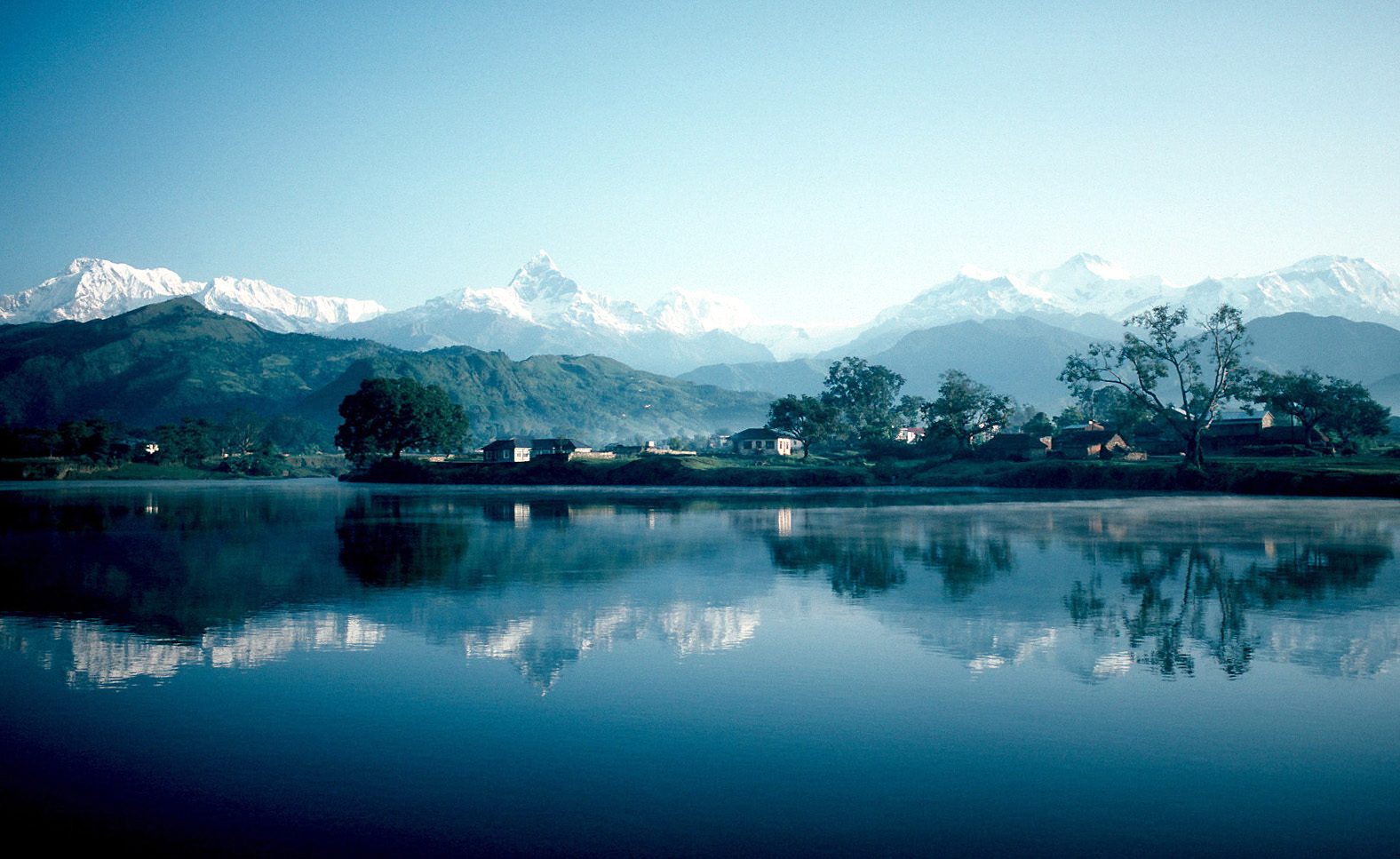
Sarangkot is Ward 18 of Pokhara, Kaski District, Nepal, after it was merged into the city in 2015. It is a popular tourist destination for those who arrive in Pokhara. At the 1991 Nepal census it had a total population of 5,060 with 1,010 individual households. The Ward is located on Sarangkot, a hill on the western side of Pokhara with an altitude of 1600m. Sarangkot is known for panoramic Himalayan views of Dhaulagiri, Annapurna and Manaslu. It also provides an expansive view of the city of Pokhara, from the extreme north to the south including the Phewa Lake. Tourists drive up the hill to watch the sunrise from the view tower at the top. In recent years, Sarangkot has been called one of the best paragliding locations in the world. The hike up from Pokhara Baglung highway at Miruwa to Sarangkot takes 90 minutes to 1.5hours. Sarangkot has one community FM radio station called Radio Sarangkot Radio is the technology of signaling and communicating using radio waves. Rad ... [...More Info...] [...Related Items...] OR: [Wikipedia] [Google] [Baidu] |
Pokhara
Pokhara ( ne, पोखरा, ) is a metropolis, metropolitan city in Nepal, which serves as the capital of Gandaki Province. It is the List of cities in Nepal, second most populous city of Nepal after Kathmandu, with 518,452 inhabitants living in 101,669 households in 2021 Nepal census, 2021. It is the country's largest metropolitan city in terms of area. The city also serves as the headquarters of Kaski District. Pokhara is located west of the capital, Kathmandu. The city is on the shore of Phewa Lake, and sits at an elevation of approximately 822m. The Annapurna Range, with three out of the ten highest peaks in the world—Dhaulagiri, Annapurna, Annapurna I and Manaslu—is within of the valley. Pokhara is considered the tourism capital of Nepal, being a base for trekkers undertaking the Annapurna Circuit through the Annapurna Conservation Area region of the Annapurna ranges in the Himalayas. The city is also home to many of the elite Gurkha soldiers, soldiers native to So ... [...More Info...] [...Related Items...] OR: [Wikipedia] [Google] [Baidu] |
Zones Of Nepal
Until the establishment of seven new provinces in 2015, Nepal was divided into 14 administrative zones ( Nepali: अञ्चल; ''anchal'') and 77 districts ( Nepali: जिल्ला; ''jillā''). The 14 administrative zones were grouped into five development regions ( Nepali: विकास क्षेत्र; ''vikās kṣetra''). Each district was headed by a Chief District Officer (CDO), who was responsible for maintaining law and order and coordinating the work of field agencies of the various government ministries. From east to west: * Eastern Development Region: **Mechi Zone, named after the Mechi River **Kosi Zone, named after the Kosi River ** Sagarmatha Zone, named after Sagarmatha (Mount Everest) * Central Development Region: **Janakpur Zone, named after its capital city **Bagmati Zone, named after the Bagmati River **Narayani Zone, named after the Narayani (lower Gandaki) River * Western Development Region: **Gandaki Zone, named after the Gandaki River ... [...More Info...] [...Related Items...] OR: [Wikipedia] [Google] [Baidu] |
Annapurna
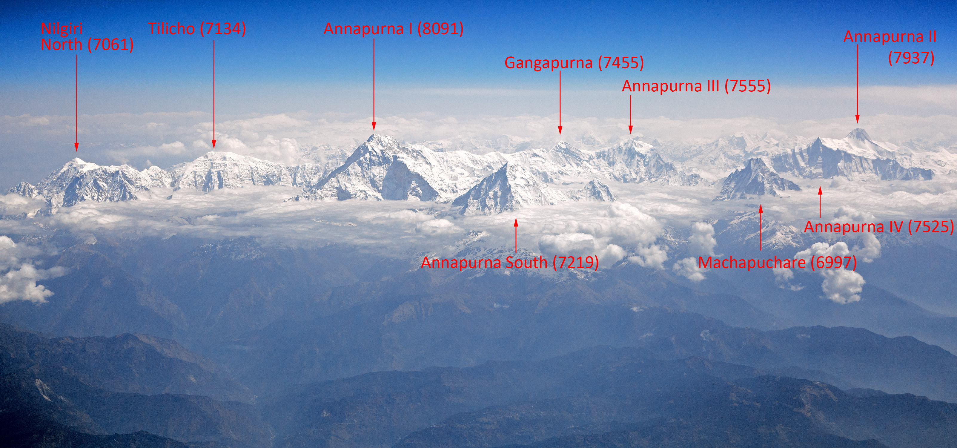
Annapurna (; ne, अन्नपूर्ण) is a mountain situated in the Annapurna mountain range of Gandaki Province, north-central Nepal. It is the tenth highest mountain in the world at above sea level and is well known for the difficulty and danger involved in its ascent. Maurice Herzog led a French expedition to its summit through the north face in 1950, making it the first eight-thousand meter peak ever successfully climbed. The entire massif and surrounding area are protected within the Annapurna Conservation Area, the first and largest conservation area in Nepal. The Annapurna Conservation Area is home to several world-class treks, including Annapurna Sanctuary and Annapurna Circuit. For decades, Annapurna I Main held the highest fatality-to-summit rate of all principal eight-thousander summits; it has, however, seen great climbing successes in recent years, with the fatality rate falling from 32% to just under 20% from 2012 to 2022. This figure places it ju ... [...More Info...] [...Related Items...] OR: [Wikipedia] [Google] [Baidu] |
Radio Sarangkot
Radio is the technology of signaling and communicating using radio waves. Radio waves are electromagnetic waves of frequency between 30 hertz (Hz) and 300 gigahertz (GHz). They are generated by an electronic device called a transmitter connected to an antenna which radiates the waves, and received by another antenna connected to a radio receiver. Radio is very widely used in modern technology, in radio communication, radar, radio navigation, remote control, remote sensing, and other applications. In radio communication, used in radio and television broadcasting, cell phones, two-way radios, wireless networking, and satellite communication, among numerous other uses, radio waves are used to carry information across space from a transmitter to a receiver, by modulating the radio signal (impressing an information signal on the radio wave by varying some aspect of the wave) in the transmitter. In radar, used to locate and track objects like aircraft, ships, spacecraft ... [...More Info...] [...Related Items...] OR: [Wikipedia] [Google] [Baidu] |
Miruwa
Miruwa is the name of Ward Number 2 in Pokhara Metropolitan City in Nepal Nepal (; ne, नेपाल ), formerly the Federal Democratic Republic of Nepal ( ne, सङ्घीय लोकतान्त्रिक गणतन्त्र नेपाल ), is a landlocked country in South Asia. It is mai .... The famous Bindhyabasini temple is located in this ward. References Wards of Pokhara {{Kaski-geo-stub ... [...More Info...] [...Related Items...] OR: [Wikipedia] [Google] [Baidu] |
Pokhara Baglung Highway
The Pokhara Baglung highway is a stretch of road that begins at ''Zero Kilometer'', Pokhara, and ends in the municipality of Baglung in Gandaki Province, Nepal Nepal (; ne, :ne:नेपाल, नेपाल ), formerly the Federal Democratic Republic of Nepal ( ne, सङ्घीय लोकतान्त्रिक गणतन्त्र नेपाल ), is a landlocked country in S .... It is part of the Government of Nepal's 1095 km Midhill Highway Project. References Roads in Nepal {{Nepal-road-stub ... [...More Info...] [...Related Items...] OR: [Wikipedia] [Google] [Baidu] |
Paragliding
Paragliding is the recreational and competitive adventure sport of flying paragliders: lightweight, free-flying, foot-launched glider aircraft with no rigid primary structure. The pilot sits in a harness or lies supine in a cocoon-like 'pod' suspended below a fabric wing. Wing shape is maintained by the suspension lines, the pressure of air entering vents in the front of the wing, and the aerodynamic forces of the air flowing over the outside. Despite not using an engine, paraglider flights can last many hours and cover many hundreds of kilometres, though flights of one to two hours and covering some tens of kilometres are more the norm. By skillful exploitation of sources of lift, the pilot may gain height, often climbing to altitudes of a few thousand metres. History In 1966, Canadian Domina Jalbert was granted a patent for a ''multi-cell wing type aerial device—''"a wing having a flexible canopy constituting an upper skin and with a plurality of longitudinally extend ... [...More Info...] [...Related Items...] OR: [Wikipedia] [Google] [Baidu] |
Manaslu
Manaslu ( ne, मनास्लु, also known as Kutang; muh-NAA-slu) is the eighth-highest mountain in the world at above sea level. It is in the Mansiri Himal, part of the Nepalese Himalayas, in the west-central part of Nepal. The name Manaslu means "mountain of the spirit" and is derived from the Sanskrit word ''manasa'', meaning "intellect" or "soul". Manaslu was first climbed on May 9, 1956, by Toshio Imanishi and Gyalzen Norbu, members of a Japanese expedition. It is said that, given the many unsuccessful attempts by the British to climb Everest before New Zealander Edmund Hillary, "just as the British consider Everest their mountain, Manaslu has always been a Japanese mountain".Mayhew, p. 326 Manaslu is the highest peak in the Gorkha District and is about east of Annapurna. The mountain's long ridges and valley glaciers offer feasible approaches from all directions and culminate in a peak that towers steeply above its surrounding landscape and is a dominant feature wh ... [...More Info...] [...Related Items...] OR: [Wikipedia] [Google] [Baidu] |
Digital Himalaya
The Digital Himalaya project was established in December 2000 by Mark Turin, Alan Macfarlane, Sara Shneiderman, and Sarah Harrison. The project's principal goal is to collect and preserve historical multimedia materials relating to the Himalaya, such as photographs, recordings, and journals, and make those resources available over the internet and offline, on external storage media. The project team have digitized older ethnographic collections and data sets that were deteriorating in their analogue formats, so as to protect them from deterioration and make them available and accessible to originating communities in the Himalayan region and a global community of scholars. The project was founded at the Department of Anthropology of the University of Cambridge, moved to Cornell University in 2002 (when a collaboration with the University of Virginia was initiated), and then back to the University of Cambridge in 2005. From 2011 to 2014, the project was jointly hosted between the Uni ... [...More Info...] [...Related Items...] OR: [Wikipedia] [Google] [Baidu] |
Dhaulagiri
Dhaulagiri is the seventh highest mountain in the world at above sea level, and the highest mountain within the borders of a single country (Nepal). It was first climbed on 13 May 1960 by a Swiss-Austrian-Nepali expedition. Annapurna I () is east of Dhaulagiri. The Kali Gandaki River flows between the two in the Kaligandaki Gorge, said to be the world's deepest. The town of Pokhara is south of the Annapurnas, an important regional center and the gateway for climbers and trekkers visiting both ranges as well as a tourist destination in its own right. Toponymy Dhaulagiri (धौलागिरी) is the Nepali name for the mountain which comes from Sanskrit where धवल (dhawala) means dazzling, white, beautiful and गिरि (giri) means mountain. Dhaulagiri I is also the highest point of the Gandaki river basin. Geography Looking north from the plains of India, most 8,000-metre peaks are obscured by nearer mountains, but in clear weather, Dhaulagiri is conspicuous ... [...More Info...] [...Related Items...] OR: [Wikipedia] [Google] [Baidu] |
Gandaki Zone
Gandaki zone ( ne, गण्डकी अञ्चल was one of the fourteen zones of Nepal, located in the Western Development Region. It was named as Sapta Gandaki after the seven tributaries (Kali Gandaki, Trishuli, Budhi Gandaki, Marsyangdi, Madi, Seti Gandaki, and Daraundi) that makes up the Gandaki River. Pokhara served as its regional and zonal headquarter. It was also the birthplace of Bhanubhakta Acharya, first poet of Nepal. The Gandaki Zone was home to multiple cultures which are unique in themselves. Some, like the Magar and Gurung, have attained fame much like the Gurkha people. Administrative subdivisions Gandaki was divided into six districts; since 2015 these districts have been redesignated as part of Gandaki Province. Annapurna Conservation Area The Annapurna Conservation Area Project (ACAP the first and largest conservation area in Nepal, covers , some 5.8% of the total land area of Nepal. Launched in 1986 as an innovative concept in the protected ... [...More Info...] [...Related Items...] OR: [Wikipedia] [Google] [Baidu] |


