|
Sanliurfa
Urfa, officially known as Şanlıurfa () and in ancient times as Edessa, is a city in southeastern Turkey and the capital of Şanlıurfa Province. Urfa is situated on a plain about 80 km east of the Euphrates River. Its climate features extremely hot, dry summers and cool, moist winters. About northeast of the city is the famous Neolithic site of Göbekli Tepe, the world's oldest known temple, which was founded in the 10th millennium BC. The area was part of a network of the first human settlements where the agricultural revolution took place. Because of its association with Jewish, Christian, and Islamic history, and a legend according to which it was the hometown of Abraham, Urfa is nicknamed the "City of Prophets." Religion is important in Urfa. The city "has become a center of fundamentalist Islamic beliefs" and "is considered one of the most devoutly religious cities in Turkey". The city is located 30 miles from the Atatürk Dam, at the heart of the Southeast An ... [...More Info...] [...Related Items...] OR: [Wikipedia] [Google] [Baidu] |
Şanlıurfa Province
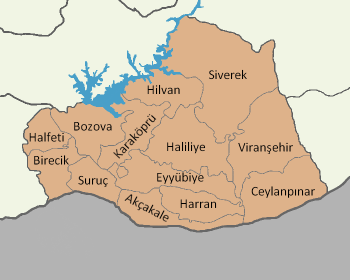
Şanlıurfa Province ( tr, Şanlıurfa ili; ku, Parêzgeha Rihayê) or simply Urfa Province is a province in southeastern Turkey. The city of Şanlıurfa is the capital of the province which bears its name. The population is 1,845,667 (2014). The province is considered part of Turkish Kurdistan and has a Kurds, Kurdish majority with a significant Arabs, Arab and Turkish people, Turkish minority. Districts Şanlıurfa province is divided into 13 Districts of Turkey, districts (capital district in bold): * Urfa (Central district. In 2014 it was split into three districts: Eyyübiye, Haliliye and Karaköprü.) * Akçakale * Birecik * Bozova * Ceylanpınar * Halfeti * Harran * Hilvan * Siverek * Suruç * Viranşehir Geography Area 18,584 km2 (7,173 sq. miles), the largest province of Southeast Anatolia with: * Adıyaman to the north; * Syria to the south; * Mardin and Diyarbakır to the east; * Gaziantep to the west; Şanlıurfa includes several major components of the ... [...More Info...] [...Related Items...] OR: [Wikipedia] [Google] [Baidu] |
Harran
Harran (), historically known as Carrhae ( el, Kάρραι, Kárrhai), is a rural town and district of the Şanlıurfa Province in southeastern Turkey, approximately 40 kilometres (25 miles) southeast of Urfa and 20 kilometers from the border crossing with Syria at Akçakale. Harran was founded at some point between the 25th and 20th centuries BC as a merchant colony by Sumerian traders from Ur. Over the course of its early history, Harran rapidly grew into a major Mesopotamian cultural, commercial and religious center. It was made a religiously and politically influential city through its association with the moon-god Sin; many prominent Mesopotamian rulers consulted with and renovated the moon-temple of Ekhulkhul in Harran. Harran came under Assyrian rule under Adad-nirari I ( BC) and became a provincial capital often second in importance only to the Assyrian capital of Assur itself. During the collapse of the Assyrian Empire, Harran briefly served as the final capital of ... [...More Info...] [...Related Items...] OR: [Wikipedia] [Google] [Baidu] |
Şanlıurfa Castle
Şanlıurfa Castle, or Urfa Castle in short, is a castle overlooking the city center of Şanlıurfa (previously Edessa), Turkey. The castle was built by the Osroene in antiquity and the current walls were constructed by the Abbasids The Abbasid Caliphate ( or ; ar, الْخِلَافَةُ الْعَبَّاسِيَّة, ') was the third caliphate to succeed the Islamic prophet Muhammad. It was founded by a dynasty descended from Muhammad's uncle, Abbas ibn Abdul-Muttalib ... in 814 AD. Today, the castle functions as an open-air museum. References Castles in Turkey {{Turkey-castle-stub ... [...More Info...] [...Related Items...] OR: [Wikipedia] [Google] [Baidu] |
Göbekli Tepe
Göbekli Tepe (, "Potbelly Hill"; known as ''Girê Mirazan'' or ''Xirabreşkê'' in Kurdish languages, Kurdish) is a Neolithic archaeological site in the Southeastern Anatolia Region of Turkey. Dated to the Pre-Pottery Neolithic, between 9500 and 8000 BCE, the site comprises a number of large circular structures supported by massive stone pillars – the world's oldest known megaliths. Many of these pillars are richly decorated with figurative anthropomorphic details, clothing, and reliefs of wild animals, providing archaeologists rare insights into prehistoric religion and the particular iconography of the period. The -high, tell (archaeology), tell also includes many smaller rectangular buildings, quarries, and stone-cut cisterns from the Neolithic, as well as some traces of activity from later periods. The site was first used at the dawn of the Southwest Asian Neolithic period, which marked the appearance of the oldest permanent human settlements anywhere in the world. Preh ... [...More Info...] [...Related Items...] OR: [Wikipedia] [Google] [Baidu] |
Arab
The Arabs (singular: Arab; singular ar, عَرَبِيٌّ, DIN 31635: , , plural ar, عَرَب, DIN 31635: , Arabic pronunciation: ), also known as the Arab people, are an ethnic group mainly inhabiting the Arab world in Western Asia, North Africa, the Horn of Africa, and the western Indian Ocean islands (including the Comoros). An Arab diaspora is also present around the world in significant numbers, most notably in the Americas, Western Europe, Turkey, Indonesia, and Iran. In modern usage, the term "Arab" tends to refer to those who both carry that ethnic identity and speak Arabic as their native language. This contrasts with the narrower traditional definition, which refers to the descendants of the tribes of Arabia. The religion of Islam was developed in Arabia, and Classical Arabic serves as the language of Islamic literature. 93 percent of Arabs are Muslims (the remainder consisted mostly of Arab Christians), while Arab Muslims are only 20 percent of the ... [...More Info...] [...Related Items...] OR: [Wikipedia] [Google] [Baidu] |
Nabataean
The Nabataeans or Nabateans (; Nabataean Aramaic: , , vocalized as ; Arabic: , , singular , ; compare grc, Ναβαταῖος, translit=Nabataîos; la, Nabataeus) were an ancient Arab people who inhabited northern Arabia and the southern Levant. Their settlements—most prominently the assumed capital city of Raqmu (present-day Petra, Jordan)—gave the name ''Nabatene'' ( grc, Ναβατηνή, translit=Nabatēnḗ) to the Arabian borderland that stretched from the Euphrates to the Red Sea. The Nabateans emerged as a distinct civilization and political entity between the 4th and 2nd centuries BCE,Taylor, Jane (2001). ''Petra and the Lost Kingdom of the Nabataeans''. London: I.B.Tauris. pp. 14, 17, 30, 31. . Retrieved 8 July 2016. with their kingdom centered around a loosely controlled trading network that brought considerable wealth and influence across the ancient world. Described as fiercely independent by contemporary Greco-Roman accounts, the Nabataeans were annexed ... [...More Info...] [...Related Items...] OR: [Wikipedia] [Google] [Baidu] |
Seleucid
The Seleucid Empire (; grc, Βασιλεία τῶν Σελευκιδῶν, ''Basileía tōn Seleukidōn'') was a Greek state in West Asia that existed during the Hellenistic period from 312 BC to 63 BC. The Seleucid Empire was founded by the Macedonian general Seleucus I Nicator, following the division of the Macedonian Empire originally founded by Alexander the Great. After receiving the Mesopotamian region of Babylonia in 321 BC, Seleucus I began expanding his dominions to include the Near Eastern territories that encompass modern-day Iraq, Iran, Afghanistan, Syria, all of which had been under Macedonian control after the fall of the former Persian Achaemenid Empire. At the Seleucid Empire's height, it had consisted of territory that had covered Anatolia, Persia, the Levant, and what are now modern Iraq, Kuwait, Afghanistan, and parts of Turkmenistan. The Seleucid Empire was a major center of Hellenistic culture. Greek customs and language were privileged; the wide variet ... [...More Info...] [...Related Items...] OR: [Wikipedia] [Google] [Baidu] |
Edessa, Greece
Edessa ( el, Έδεσσα, ; also known as the "''City of Waters and of the 5 Senses''"), until 1923 Vodena ( el, link=no, Βοδενά), is a city in northern Greece and the capital of the Pella regional unit, in the Central Macedonia region of Greece. It was also the capital of the defunct province of the same name. Edessa holds a special place in the history of the Greek world as, according to some ancient sources, it was here that Caranus established the first capital of ancient Macedon. Later, under the Byzantine Empire, Edessa benefited from its strategic location, controlling the Via Egnatia as it enters the Pindus mountains, and became a center of medieval Greek culture, famed for its strong walls and fortifications. In the modern period, Edessa was one of Greece's industrial centers until the middle of the 20th century, with many textile factories operating in the city and its immediate vicinity. Today however its economy mainly relies on services and tourism. Edessa hos ... [...More Info...] [...Related Items...] OR: [Wikipedia] [Google] [Baidu] |
Daisan River
The Daysan River or Daisan River was the name of the river that flowed through Urfa, a tributary of the Khabur. Historically known as the Scirtus ( grc, Σκίρτος),Procopius, ''de Aed.'' 2.7 Procopius describes it as a river of Mesopotamia, a western tributary of the Chaboras (modern Khabur). It flowed from 25 sources, and ran past Edessa. (''Chron. Edess.'' in Asseman, ''Bibl. Or.'' i. p. 388.) Its name, which signifies the skipping or jumping (from σκιρτάω), is said to have been derived from its rapid course and its frequent overflowings; and its present name of Daysan or Daisan means the same thing. The river has flooded Edessa numerous times, including in 204, 305, and 415 CE. The Syriac writer Bardaisan Bardaisan (11 July 154 – 222 AD; syr, ܒܪ ܕܝܨܢ, ''Bardaiṣān''), known in Arabic as Ibn Daisan (ابن ديصان) and in Latin as Bardesanes, was a Syriac-speaking Assyrian or ParthianProds Oktor Skjaervo. ''Bardesanes''. Encyclopædia ... takes his na ... [...More Info...] [...Related Items...] OR: [Wikipedia] [Google] [Baidu] |
Southeast Anatolia Project
The Southeastern Anatolia Project ( tr, Güneydoğu Anadolu Projesi, GAP) is a multi-sector integrated regional development project based on the concept of sustainable development for the 9 million people (2005) living in the Southeastern Anatolia region of Turkey. GAP's basic aim is to eliminate regional development disparities by raising incomes and living standards and to contribute to the national development targets of social stability and economic growth by enhancing the productive and employment generating capacity of the rural sector. The total cost of the project is over 100 billion Turkish lira (TL) (2017 adjusted price), of which 30.6 billion TL of this investment was realized at the end of 2010. The real investment (corrected value) was 72.6% for the end of 2010. (in Turkish) The project area covers nine provinces (Adıyaman, Batman, Diyarbakır, Gaziantep, Kilis, Siirt, Şanlıurfa, Mardin, and Şırnak) which are located in the basins of the Euphrates and Tigris and i ... [...More Info...] [...Related Items...] OR: [Wikipedia] [Google] [Baidu] |
Taurus Mountains
The Taurus Mountains ( Turkish: ''Toros Dağları'' or ''Toroslar'') are a mountain complex in southern Turkey, separating the Mediterranean coastal region from the central Anatolian Plateau. The system extends along a curve from Lake Eğirdir in the west to the upper reaches of the Euphrates and Tigris rivers in the east. It is a part of the Alpide belt in Eurasia. Etymology The mountain range under the current name was mentioned in ''The Histories'' by Polybius as Ταῦρος (''Taûros''). Heinrich Kiepert writes in ''Lehrbuch der alten Geographie'' that the name was borrowed into Ancient Greek from the Semitic (Old Aramaic) root טורא ''ṭūrā'', meaning "mountain". Geography The Taurus mountains are divided into three chains from west to east as follows; * Western Taurus (Batı Toroslar) *Central Taurus (Orta Toroslar) *Southeastern Taurus (Güneydoğu Toroslar) Western Taurus The Western Taurus Mountains form an arc around the Gulf of Antalya. It includes th ... [...More Info...] [...Related Items...] OR: [Wikipedia] [Google] [Baidu] |


.jpg)