|
Swiss National Redoubt
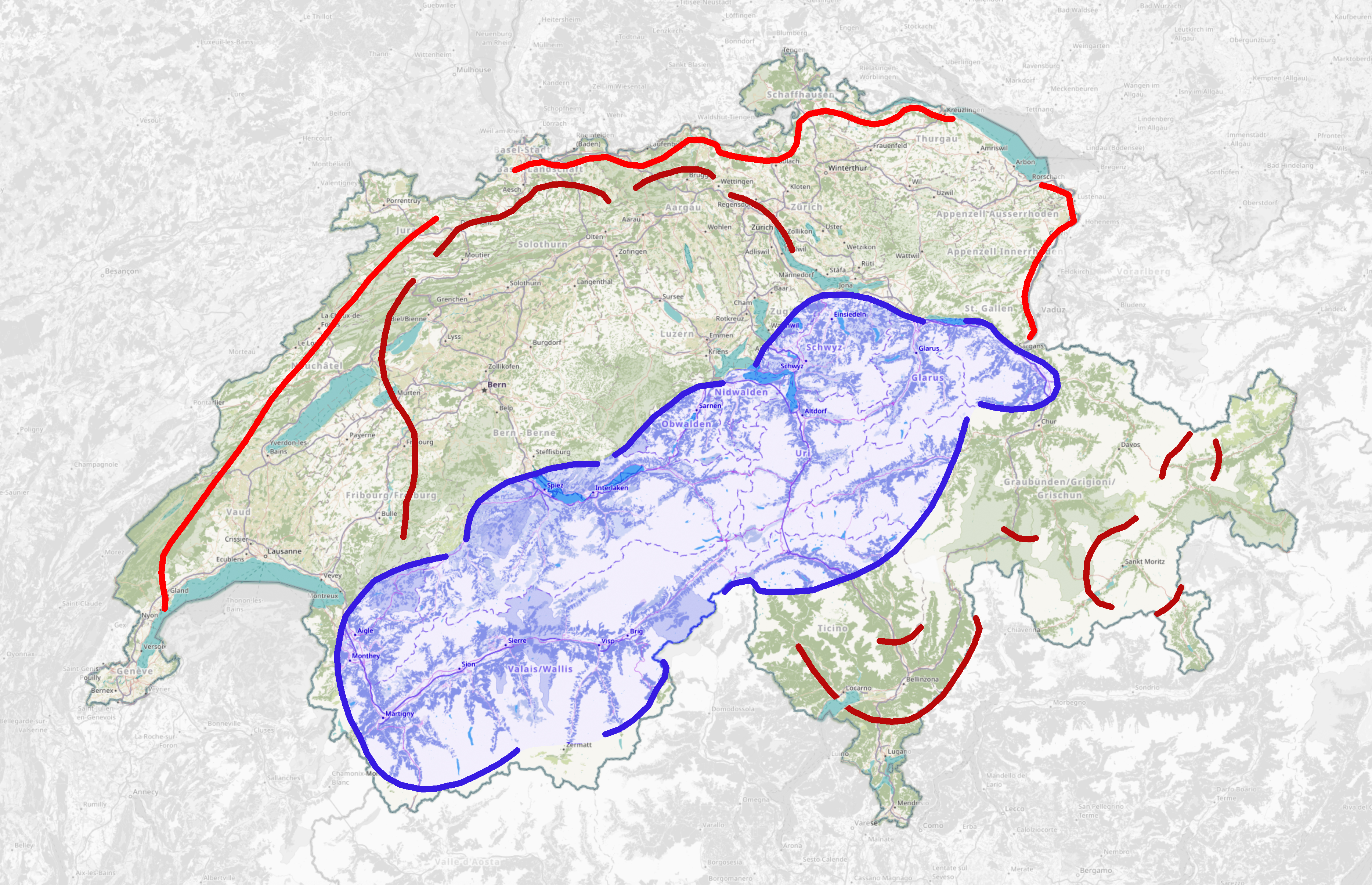
The Swiss National Redoubt (; ; ; ) is a defensive plan developed by the Swiss government beginning in the 1880s to respond to foreign invasion. In the opening years of the Second World War the plan was expanded and refined to deal with a potential German invasion. The term "National Redoubt" primarily refers to the fortifications begun in the 1880s that secured the mountainous central part of Switzerland, providing a defended refuge for a retreating Swiss Army. The National Redoubt encompassed a widely distributed set of fortifications on a general east-west line through the Alps, centering around the major fortress complexes of St. Maurice, St. Gotthard, and Sargans. These fortresses primarily defended the alpine crossings between Germany and Italy and were outside the industrialized and populated regions of Switzerland. These regions were defended by the "Border Line", and the "Army Position" somewhat farther back. While not intended as an impassable barrier, these lines ... [...More Info...] [...Related Items...] OR: [Wikipedia] [Google] [Baidu] |
Reduit Schweiz Neu
A reduit is a fortified structure such as a citadel or a keep into which the defending troops can retreat when the outer defences are breached. The term is also used to describe an area of a country, which, through a ring of heavy fortifications or through enhancing through fortification the defences offered by natural features such as mountains, will be defended even when the rest of the country is occupied by a hostile power. . An entry for this word was first included in New English Dictionary, 1904. *1948 Times 31 Dec. 3/3 "The obsolete conception of a national reduit has been abandoned in favour of an extra-territorial base established in the Belgian Congo". *2003 Macpherson ''Amer. Intelligence War-time London'' vi. 177 "As for the Reduit (or Redoubt), this was the rumoured area for 'a last-ditch stand' in the Bavarian, Austrian and Italian Alps". National Reduit In English the term National redoubt is fairly commonly used. A redoubt is an outlying fortification, so its ... [...More Info...] [...Related Items...] OR: [Wikipedia] [Google] [Baidu] |
Neutral Country
A neutral country is a state that is neutral towards belligerents in a specific war or holds itself as permanently neutral in all future conflicts (including avoiding entering into military alliances such as NATO, CSTO or the SCO). As a type of non-combatant status, nationals of neutral countries enjoy protection under the law of war from belligerent actions to a greater extent than other non-combatants such as enemy civilians and prisoners of war. Different countries interpret their neutrality differently: some, such as Costa Rica, have demilitarized, while Switzerland holds to "armed neutrality", to deter aggression with a sizeable military, while barring itself from foreign deployment. Not all neutral countries avoid any foreign deployment or alliances, as Austria and Ireland have active UN peacekeeping forces and a political alliance within the European Union. Sweden's traditional policy was not to participate in military alliances, with the intention of staying neutral in t ... [...More Info...] [...Related Items...] OR: [Wikipedia] [Google] [Baidu] |
Great Depression
The Great Depression (19291939) was an economic shock that impacted most countries across the world. It was a period of economic depression that became evident after a major fall in stock prices in the United States. The economic contagion began around September and led to the Wall Street stock market crash of October 24 (Black Thursday). It was the longest, deepest, and most widespread depression of the 20th century. Between 1929 and 1932, worldwide gross domestic product (GDP) fell by an estimated 15%. By comparison, worldwide GDP fell by less than 1% from 2008 to 2009 during the Great Recession. Some economies started to recover by the mid-1930s. However, in many countries, the negative effects of the Great Depression lasted until the beginning of World War II. Devastating effects were seen in both rich and poor countries with falling personal income, prices, tax revenues, and profits. International trade fell by more than 50%, unemployment in the U.S. rose to 23% and ... [...More Info...] [...Related Items...] OR: [Wikipedia] [Google] [Baidu] |
Job Creation Program
Unemployment, according to the OECD (Organisation for Economic Co-operation and Development), is people above a specified age (usually 15) not being in paid employment or self-employment but currently available for work during the reference period. Unemployment is measured by the unemployment rate, which is the number of people who are unemployed as a percentage of the labour force (the total number of people employed added to those unemployed). Unemployment can have many sources, such as the following: * new technologies and inventions * the status of the economy, which can be influenced by a recession * competition caused by globalization and international trade * policies of the government * regulation and market Unemployment and the status of the economy can be influenced by a country through, for example, fiscal policy. Furthermore, the monetary authority of a country, such as the central bank, can influence the availability and cost for money through its monetary ... [...More Info...] [...Related Items...] OR: [Wikipedia] [Google] [Baidu] |
Czechoslovak Border Fortifications
Czechoslovakia built a system of border fortifications as well as some fortified defensive lines inland, from 1935 to 1938 as a defensive countermeasure against the rising threat of Nazi Germany. The objective of the fortifications was to prevent the taking of key areas by an enemy—not only Germany but also Hungary and Poland—by means of a sudden attack before the mobilization of the Czechoslovak Army could be completed, and to enable effective defense until allies—Britain and France, and possibly the Soviet Union—could help. History With the rise of Hitler and his demands for unification of German minorities, including the Sudeten Germans, and the return of other claimed territories—Sudetenland—the alarmed Czechoslovak leadership began defensive plans. While some basic defensive structures were built early on, it was not until after conferences with the French military on their design that a full-scale effort began. A change in the design philosophy was noticeable in ... [...More Info...] [...Related Items...] OR: [Wikipedia] [Google] [Baidu] |
Maginot Line
The Maginot Line (french: Ligne Maginot, ), named after the French Minister of War André Maginot, is a line of concrete fortifications, obstacles and weapon installations built by France in the 1930s to deter invasion by Germany and force them to move around the fortifications. The Maginot Line was impervious to most forms of attack. In consequence, the Germans invaded through the Low Countries in 1940, passing it to the north. The line, which was supposed to be fully extended further towards the west to avoid such an occurrence, was finally scaled back in response to demands from Belgium. Indeed, Belgium feared it would be sacrificed in the event of another German invasion. The line has since become a metaphor for expensive efforts that offer a false sense of security. Constructed on the French side of its borders with Italy, Switzerland, Germany, Luxembourg and Belgium, the line did not extend to the English Channel. French strategy therefore envisioned a move into Belgium ... [...More Info...] [...Related Items...] OR: [Wikipedia] [Google] [Baidu] |
Aftermath Of World War I
The aftermath of World War I saw drastic political, cultural, economic, and social change across Eurasia, Africa, and even in areas outside those that were directly involved. Four empires collapsed due to the war, old countries were abolished, new ones were formed, boundaries were redrawn, international organizations were established, and many new and old ideologies took a firm hold in people's minds. World War I also had the effect of bringing political transformation to most of the principal parties involved in the conflict, transforming them into electoral democracies by bringing near-universal suffrage for the first time in history, as in Germany ( 1919 German federal election), Great Britain (1918 United Kingdom general election), and Turkey ( 1923 Turkish general election). Blockade of Germany Through the period from the Armistice of 11 November 1918 until the signing of the Treaty of Versailles with the Weimar Republic on 28 June 1919, the Allies maintained the naval blo ... [...More Info...] [...Related Items...] OR: [Wikipedia] [Google] [Baidu] |
Saint-Maurice, Switzerland
Saint-Maurice is a city in the Swiss canton of Valais and the capital of the district of Saint-Maurice. On 1 January 2013, the former municipality of Mex merged into the municipality of Saint-Maurice.Nomenklaturen – Amtliches Gemeindeverzeichnis der Schweiz accessed 9 February 2013 Saint-Maurice is the site of the outpost of and the 6th-century |
Central Alps
The Alps form a large mountain range dominating Central Europe, including parts of Italy, France, Switzerland, Liechtenstein, Austria, Slovenia, Germany and possibly Hungary (if one includes the Kőszeg Mountains). This article describes the delimitation of the Alps as a whole and of subdivisions of the range, follows the course of the main chain of the Alps and discusses the lakes and glaciers found in the region. Boundaries In some areas, such as the edge of the Po Basin, the edge of the Alps is unambiguous, but where the Alps border on other mountainous or hilly regions, the border may be harder to place. These neighbouring ranges include the Apennines, the Massif Central, the Jura, the Black Forest, the Bohemian Forest, the Carpathians, and the mountains of the Balkan Peninsula. The boundary between the Apennines and the Alps is usually taken to be the Colle di Cadibona, at 435 m above sea level, above Savona on the Italian coast. The Rhône forms a clear boundary b ... [...More Info...] [...Related Items...] OR: [Wikipedia] [Google] [Baidu] |
Grimsel Pass
The Grimsel Pass (german: Grimselpass; french: Col du Grimsel; it, Passo del Grimsel) is a mountain pass in Switzerland, crossing the Bernese Alps at an elevation of . The pass connects the Haslital, the upper valley of the river Aare, with the upper valley of the Rhône. In so doing, and as the Aare is a tributary of the Rhine, the pass crosses the continental divide between the North Sea and the Mediterranean Sea. A paved road follows the pass, running from Gletsch to Meiringen. The road is normally closed between October and May, due to the high snowfall on the pass. As it is the only direct road pass between the cantons of Bern and Valais across the Bernese Alps, attempts are made to keep the road open as long as possible with snow ploughs. A PostBus Switzerland service uses the pass several times a day, connecting Meiringen and Oberwald. The Grimsel Pass road is part of the Aare Route, which is national cycle route 8 of Switzerland. It has been used on several occasi ... [...More Info...] [...Related Items...] OR: [Wikipedia] [Google] [Baidu] |
Furka Pass
Furka Pass (french: Le Col de la Furka), with an elevation of , is a high mountain pass in the Swiss Alps connecting Gletsch, Valais with Realp, Uri. The Furka Oberalp Bahn line through the Furka Tunnel bypasses the pass. The base tunnel opened in 1982 and replaced a tunnel at 2100 metres. The Furka Pass was used as a location in the James Bond film '' Goldfinger''. One curve on the east side of the pass is even named "James Bond Strasse". At the sign, there is a lookout point with a small parking area. Visitors can also park next to Hotel Belvédère, close to the top of the pass on the west side, and take the short walk to the Rhone Glacier Ice Grotto. The glacier moves 30–40 meters a year and the 100 meter long tunnel and ice chamber can be visited from June when the road opens. See also * List of highest paved roads in Europe * List of mountain passes * List of the highest Swiss passes This is a list of the highest road passes in Switzerland. It includes passes in the ... [...More Info...] [...Related Items...] OR: [Wikipedia] [Google] [Baidu] |
Oberalp Pass
Oberalp Pass ( rm, Alpsu or ''Cuolm d'Ursera''; german: Oberalppass) (2044 meters above sea level) is a high mountain pass in the Swiss Alps connecting the cantons of Graubünden and Uri between Disentis/Mustér and Andermatt. Winter closure The public road that crosses the pass is closed in winter, but the Furka-Oberalp railway line, now part of the Matterhorn Gotthard Bahn, runs year round and provides a limited shuttle for cars in winter (reservation required). When the road closes depends on snowfall and varies between the end of October and the beginning of December. The road opens again in spring, usually by the end of April but sometimes not until mid May. In winter, a ski area extends to the Graubünden side, connecting the pass well into the Tujetsch territory to Dieni, near Rueras. Source of the Rhine river The Rhine springs from a source nearby (Tomasee), which can be accessed by hiking two hours from Oberalp Pass. A multiday trekking route is signposted across Obera ... [...More Info...] [...Related Items...] OR: [Wikipedia] [Google] [Baidu] |


