|
Svirlag
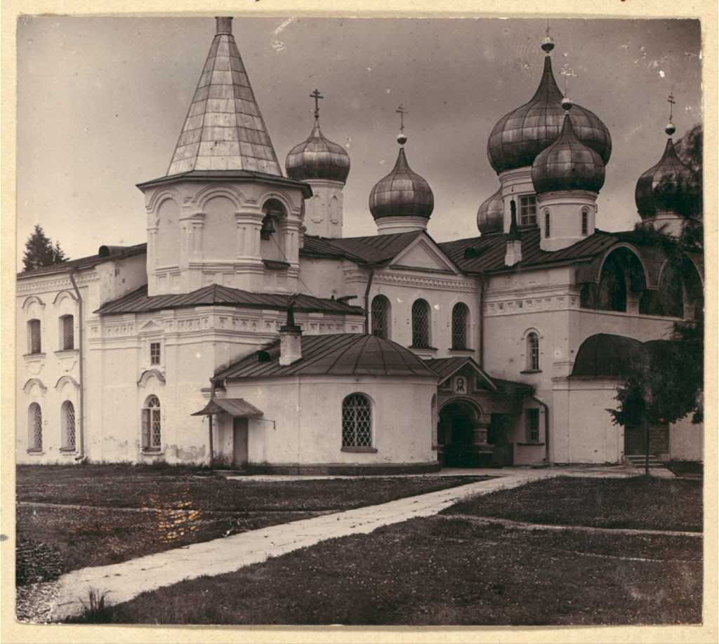
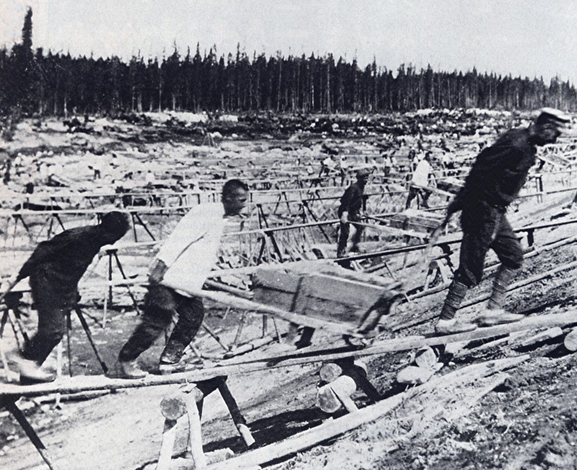
Svirlag, SvirLAG (Svirskiy Lager' – Svir Concentration-Camp, russian: Свирлаг, also / – ) was a Soviet forced labour camp run by NKVD's GULAG Directorate. It was located on the river Svir (hence the name Svirskiy in Russian) in the forests by the town Lodeynoye Pole, 244 km north-east of Saint Petersburg, in Leningrad oblast, Vepsland – the land of the Vepses, operated in the 1930s (Joseph Stalin's time) and onwards. SvirLAG concentration camp was supplier of wood to Moscow and Saint Petersburg. The camp was established on November 17, 1931. The number of those who died or were killed in Svirlag in 1930s (the times of the most numerous and heavy executions that took place in SvirLAG seem to be 1931–1937) is measured in thousands of victims. In 1935, 36.500 inmates were kept in this camp. The camp was located in the medieval buildings of what was formerly the Alexander-Svirsky Monastery. Bolsheviks closed and vandalized the monastery in 1918 (it finally ... [...More Info...] [...Related Items...] OR: [Wikipedia] [Google] [Baidu] |
Svir River
The Svir (, Veps: , Karelian/Finnish: ) is a river in Podporozhsky, Lodeynopolsky, and Volkhovsky districts in the north-east of Leningrad Oblast, Russia. It flows westwards from Lake Onega to Lake Ladoga, thus connecting the two largest lakes of Europe. It is the largest river flowing into Lake Ladoga. The length of the Svir is , whereas the area of its drainage basin is . The towns of Podporozhye and Lodeynoye Pole, as well as urban-type settlements Voznesenye, Nikolsky, Vazhiny, and Svirstroy are located at the banks of the Svir. After Peter the Great connected the Svir with the Neva by the Ladoga Canal in the 18th century, the river has been part of the Mariinsk Canal System, currently the Volga–Baltic Waterway. The Onega Canal is a bypass of Lake Onega from the south, which connects the Svir with the Vytegra. The Svir is heavily used for navigation, with both cargo traffic and cruise ships. There are two dams with hydroelectric power plants on the river. The Lowe ... [...More Info...] [...Related Items...] OR: [Wikipedia] [Google] [Baidu] |
Lodeynoye Pole
Lodeynoye Pole (russian: Лоде́йное По́ле, lit. ''the field of boats'') is a town and the administrative center of Lodeynopolsky District in Leningrad Oblast, Russia, located on the left bank of the Svir River (Lake Ladoga's basin) northeast of St. Petersburg. Population: 21,400 (1972). History It was founded in 1702 on the spot of the village of Mokrishvitsa, where Peter the Great had established the Olonets Shipyard. In 1703, the first ship of the Baltic Fleet was built here—a 28-cannon frigate called ''Shtandart''. In 1704, six more frigates, four shnyavas, four galleys, and twenty-four semi-galleys were constructed, which would form the first Russian squadron in the Baltic Sea. Over four hundred sailboats and rowboats were built throughout the shipyard's existence. In the course of the administrative reform carried out in 1708 by Peter the Great, Lodeynoye Pole was included into Ingermanland Governorate (known from 1710 as Saint Petersburg Governor ... [...More Info...] [...Related Items...] OR: [Wikipedia] [Google] [Baidu] |
Alexander-Svirsky Monastery
Alexander-Svirsky Monastery (Александро-Свирский монастырь) is a Russian Orthodox monastery situated deep in the woods of the Leningrad Oblast, just south from its border with the Republic of Karelia. The golden age of this cloister was in the 17th century. It boasts one of the few preserved three-tented belfries and medieval clock towers in Russia. The abbey was founded in 1487, when a monk of the Valaam Monastery, named Alexander, settled between Roshchinsky and Holy lakes, 20 km to the east from Lake Ladoga and 6 km from the Svir River. During his life in the woods, he had a vision of the Holy Trinity who ordered him to build two oaken chapels dedicated to the Trinity and the Saviour's Transfiguration. These churches gave birth to the twin Trinity and the Transfiguration cloisters, collectively known as the Alexander Svirsky Monastery. The monastery's founder died on August 30, 1533, and was buried at the Transfiguration cloister, which ... [...More Info...] [...Related Items...] OR: [Wikipedia] [Google] [Baidu] |
Forced Labour Camp
A labor camp (or labour camp, see spelling differences) or work camp is a detention facility where inmates are forced to engage in penal labor as a form of punishment. Labor camps have many common aspects with slavery and with prisons (especially prison farms). Conditions at labor camps vary widely depending on the operators. Convention no. 105 of the United Nations International Labour Organization (ILO), adopted internationally on 27 June 1957, abolished camps of forced labor. In the 20th century, a new category of labor camps developed for the imprisonment of millions of people who were not criminals ''per se'', but political opponents (real or imagined) and various so-called undesirables under communist and fascist regimes. Some of those camps were dubbed "reeducation facilities" for political coercion, but most others served as backbones of industry and agriculture for the benefit of the state, especially in times of war. Precursors Early-modern states could exploit ... [...More Info...] [...Related Items...] OR: [Wikipedia] [Google] [Baidu] |
Amur Oblast
Amur Oblast ( rus, Аму́рская о́бласть, r=Amurskaya oblast, p=ɐˈmurskəjə ˈobləsʲtʲ) is a federal subject of Russia (an oblast), located on the banks of the Amur and Zeya Rivers in the Russian Far East. The administrative center of the oblast, the city of Blagoveshchensk, is one of the oldest settlements in the Russian Far East, founded in 1856. It is a traditional center of trade and gold mining. The territory is accessed by two railways: the Trans-Siberian Railway and the Baikal–Amur Mainline. As of the 2010 Census, the oblast's population was 830,103. Amur Krai () or Priamurye () were unofficial names for the Russian territories by the Amur River used in the late Russian Empire that approximately correspond to modern Amur Oblast. Geography Amur Oblast is located in the southeast of Russia, between Stanovoy Range in the north and the Amur River in the south, and borders with the Sakha Republic in the north, Khabarovsk Krai and the Jewish Auto ... [...More Info...] [...Related Items...] OR: [Wikipedia] [Google] [Baidu] |
Volga
The Volga (; russian: Во́лга, a=Ru-Волга.ogg, p=ˈvoɫɡə) is the List of rivers of Europe#Rivers of Europe by length, longest river in Europe. Situated in Russia, it flows through Central Russia to Southern Russia and into the Caspian Sea. The Volga has a length of , and a catchment area of «Река Волга» , Russian State Water Registry which is more than twice the size of Ukraine. It is also Europe's largest river in terms of average discharge (hydrology), discharge at delta – between and – and of drainage basin. It is widely regarded as the Rivers in Russia, national river of Russia. The hypothetical old Russian state, the Rus' Khaganate, arose along the Volga . Historically, the river served as an important meeting place of various Eurasian civilizations. The river flows in Russia through forests, Fo ... [...More Info...] [...Related Items...] OR: [Wikipedia] [Google] [Baidu] |
Ukhta
Ukhta (russian: Ухта́; kv, Уква, ''Ukva'') is an important industrial town in the Komi Republic of Russia. Population: It was previously known as ''Chibyu'' (until 1939). History Oil springs along the Ukhta River were already known in the 17th century. In the mid-19th century, industrialist M. K. Sidorov started to drill for oil in this area. It was one of the first oil wells in Russia. There was homecraft oil-field in 1920–1921 in Ukhta. Lying on the river of the same name, the settlement was founded as the village of Chibyu in 1929, but in 1939 it was renamed Ukhta. It was granted town status in 1943 when it was linked to the Pechora Railway. To the east of the town is Sosnogorsk, and to the southwest—Yarega. In addition to its rail link, Ukhta also has an airport. The town expanded in the 1940s and 1950s by use of political prisoners' forced labor (see: gulag). Administrative and municipal status Within the framework of administrative divisions, it i ... [...More Info...] [...Related Items...] OR: [Wikipedia] [Google] [Baidu] |
Bamlag
Baikal Amur Corrective Labor Camp (Bamlag) (russian: Байка́ло-Аму́рский исправи́тельно-трудово́й ла́герь, Бамла́г) was a subdivision of GULAG which existed during 1932-1948. Its administration, headed by Naftaly Frenkel (1933-1938), was headquartered in the settlement of Svobodny, Amur Oblast. Its main activity was construction of the Baikal Amur Mainline and secondary railroad branches. Its peak headcount was about 201,000 (1938). In 1938 it was dismantled into several camps. Notable convicts * |

_(1788).png)


