|
Supreme Executive Council Of The Commonwealth Of Pennsylvania
The Supreme Executive Council of the Commonwealth of Pennsylvania was the collective directorial executive branch of the Pennsylvanian state government between 1777 and 1790. It was headed by a president and a vice president (analogous to a governor and lieutenant governor, respectively). The best-known member of the Council was Benjamin Franklin, who also served as its sixth president. 1776 Constitution The 1776 Constitution of the Commonwealth of Pennsylvania was framed by a constitutional convention called at the urging of the Continental Congress. The convention began work in Philadelphia on July 15, 1776—less than two weeks following adoption of the Declaration of Independence. The Constitution was adopted September 28 of the same year. The document included both ''A Declaration of the Rights of the Inhabitants of the Commonwealth'' and a ''Plan or Frame of Government''. The latter includes 47 sections, several of which deal with the formation and function of the Supre ... [...More Info...] [...Related Items...] OR: [Wikipedia] [Google] [Baidu] |
Directorial System
A directorial republic is a country ruled by a college of several people who jointly exercise the powers of a head of state A head of state (or chief of state) is the public persona who officially embodies a state Foakes, pp. 110–11 " he head of statebeing an embodiment of the State itself or representatitve of its international persona." in its unity and l ... and/or a head of government. In political history, the term directory, in French ', is applied to high collegial institutions of state composed of members styled director. The most important of these by far was the French Directory, Directory of 1795–1799 in France. The system was inspired by the Pennsylvania Constitution of 1776, which prominently featured a collegial 12-member Supreme Executive Council with a ''primus inter pares'' President. Variants of this form of government, based on the French model, were also established in the European regions conquered by France during the French Revolutionary ... [...More Info...] [...Related Items...] OR: [Wikipedia] [Google] [Baidu] |
Bucks County, Pennsylvania
Bucks County is a county in the Commonwealth of Pennsylvania. As of the 2020 census, the population was 646,538, making it the fourth-most populous county in Pennsylvania. Its county seat is Doylestown. The county is named after the English county of Buckinghamshire. Bucks County is part of the northern boundary of the Philadelphia– Camden– Wilmington, PA– NJ– DE– MD Metropolitan Statistical Area, more commonly known as the Delaware Valley. It is located immediately northeast of Philadelphia and forms part of the southern tip of the eastern state border with New Jersey. History Founding Bucks County is one of the three original counties created by colonial proprietor William Penn in 1682. Penn named the county after Buckinghamshire, the county in which he lived in England. He built a country estate, Pennsbury Manor, in Falls Township, Bucks County. Some places in Bucks County were named after locations in Buckinghamshire, including Buckingham and Buckingham T ... [...More Info...] [...Related Items...] OR: [Wikipedia] [Google] [Baidu] |
Dauphin County, Pennsylvania
Dauphin County (; Pennsylvania Dutch: Daffin Kaundi) is a county in the Commonwealth of Pennsylvania. As of the 2020 census, the population was 286,401. The county seat and the largest city is Harrisburg, Pennsylvania's state capital and ninth largest city. The county was created ("erected") on March 4, 1785, from part of Lancaster County and was named after Louis Joseph, Dauphin of France, the first son of King Louis XVI. Dauphin County is included in the Harrisburg–Carlisle Metropolitan Statistical Area. Located within the county is Three Mile Island Nuclear Generating Station, site of the 1979 nuclear core meltdown. The nuclear power plant closed in 2019. Geography According to the U.S. Census Bureau, the county has a total area of , of which is land and (5.9%) is water. The county is bound to its western border by the Susquehanna River (with the exception of a small peninsula next to Duncannon). The area code is 717 with an overlay of 223. Adjacent counties * N ... [...More Info...] [...Related Items...] OR: [Wikipedia] [Google] [Baidu] |
Montgomery County, Pennsylvania
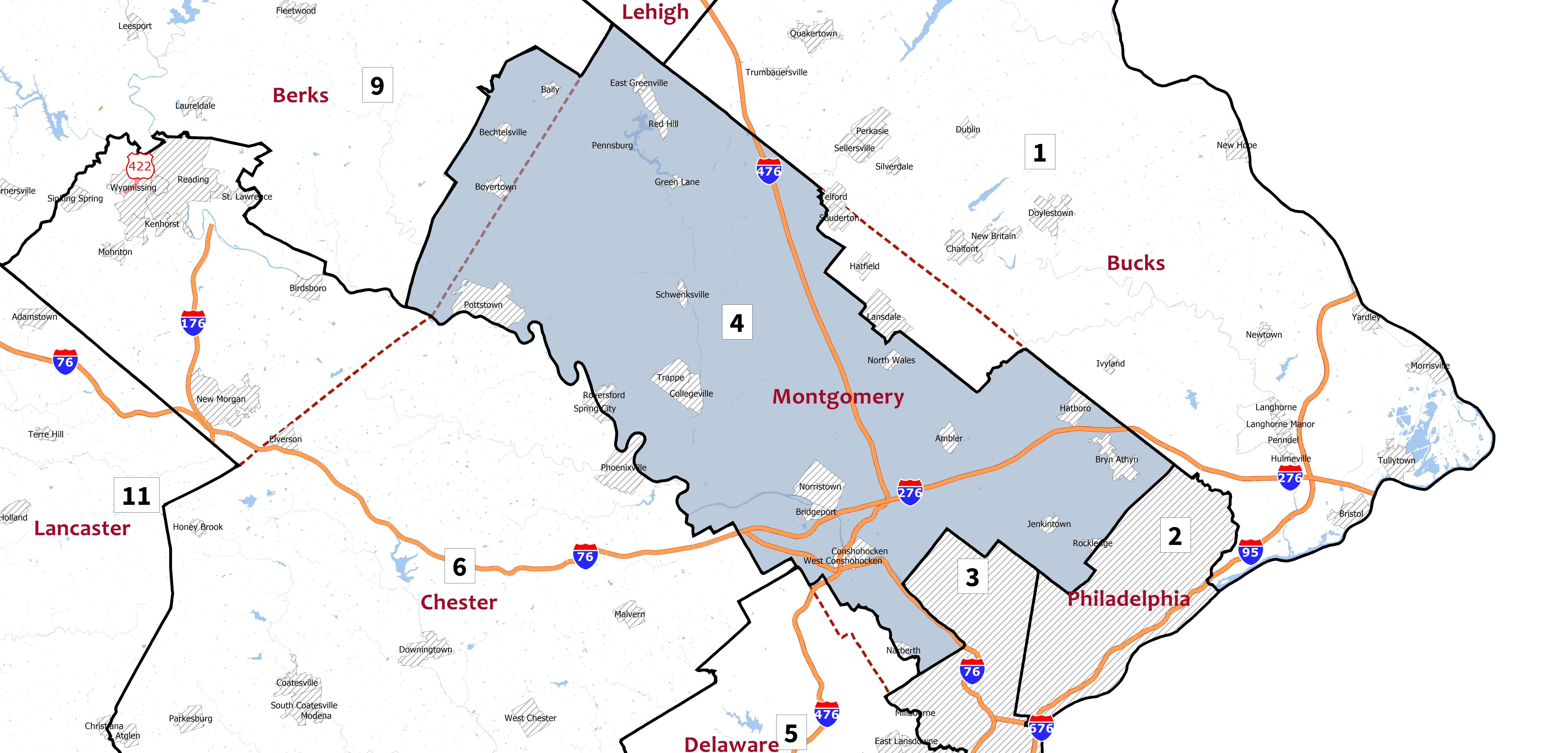
Montgomery County is a county in the Commonwealth of Pennsylvania. It is the third-most populous county in Pennsylvania and the 73rd-most populous county in the United States. As of the 2020 census, the population of the county was 856,553, representing a 7.1% increase from the 799,884 residents enumerated in the 2010 census. Montgomery County is located adjacent to and northwest of Philadelphia. The county seat and largest city is Norristown. Montgomery County is geographically diverse, ranging from farms and open land in the extreme north of the county to densely populated suburban neighborhoods in the southern and central portions of the county. Montgomery County is included in the Philadelphia- Camden- Wilmington PA- NJ- DE- MD metropolitan statistical area, sometimes expansively known as the Delaware Valley. The county marks part of the Delaware Valley's northern border with the Lehigh Valley region of Pennsylvania. In 2010, Montgomery County was the 66th-wealthiest ... [...More Info...] [...Related Items...] OR: [Wikipedia] [Google] [Baidu] |
Franklin County, Pennsylvania
Franklin County is a county in the Commonwealth of Pennsylvania. As of the 2020 census, the population was 155,932 Its county seat is Chambersburg. Franklin County comprises the Chambersburg–Waynesboro, PA Metropolitan Statistical Area, which is also included in the Washington–Baltimore–Arlington-DC–MD–VA–WV–PA Combined Statistical Area. It lies to a large extent within the Cumberland Valley. History Originally part of Lancaster County (1729), then York County (1749), then Cumberland County (1750), Franklin County became an independent jurisdiction on September 9, 1784, relatively soon after the end of the American Revolutionary War. It is named in honor of Founding Father Benjamin Franklin. Geography According to the U.S. Census Bureau, the county has a total area of , of which is land and (0.08%) is water. Franklin County is in the watershed of the Chesapeake Bay and the overwhelming majority of it is drained by the Potomac River, but the Conodoguinet ... [...More Info...] [...Related Items...] OR: [Wikipedia] [Google] [Baidu] |
Fayette County, Pennsylvania
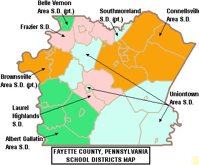
Fayette County is a county in the Commonwealth of Pennsylvania. It is located in southwestern Pennsylvania, adjacent to Maryland and West Virginia. As of the 2020 census, the population was 128,804. Its county seat is Uniontown. The county was created on September 26, 1783, from part of Westmoreland County and named after the Marquis de Lafayette. Fayette County is part of the Pittsburgh, PA Metropolitan Statistical Area. The southern border of Fayette County is the southern border of Pennsylvania at both the Pennsylvania–Maryland state line (the Mason–Dixon line) and the Pennsylvania–West Virginia state line. History The first Europeans in Fayette County were explorers, who had used an ancient American Indian trail that bisected the county on their journey across the Appalachian Mountains. In 1754, when control of the area was still in dispute between France and Great Britain, 22-year-old George Washington fought against the French at the Battle of Jumonville Glen ... [...More Info...] [...Related Items...] OR: [Wikipedia] [Google] [Baidu] |
Washington County, Pennsylvania
Washington County is a county in the Commonwealth of Pennsylvania. As of the 2020 census, the population was 209,349. Its county seat is Washington. Washington County is part of the Pittsburgh, PA Metropolitan Statistical Area. The county is home to Washington County Airport, three miles (5 km) southwest of Washington. History The county was created on March 28, 1781, from part of Westmoreland County. The city and county were both named after American Revolutionary War leader George Washington, who eventually became the first President of the United States. The town of Charleroi got its name from the Belgian city of Charleroi. There lived many Belgian immigrants in the Monongahela area at the end of the 19th century, some of whom were glass makers. Geography According to the U.S. Census Bureau, the county has a total area of , of which is land and (0.5%) is water. Surrounding counties * Beaver County (north) * Allegheny County (NNE-northeast) * Westmoreland Cou ... [...More Info...] [...Related Items...] OR: [Wikipedia] [Google] [Baidu] |
Westmoreland County, Pennsylvania
Westmoreland County is a county in the Commonwealth of Pennsylvania, United States. As of the 2020 census, the population was 364,663. The county seat is Greensburg. Formed from, successively, Lancaster, Northumberland, and later Bedford counties, Westmoreland County was founded on February 26, 1773, and was the first county in the colony of Pennsylvania whose entire territorial boundary was located west of the Allegheny Mountains. Westmoreland County originally included the present-day counties of Fayette, Washington, Greene, and parts of Beaver, Allegheny, Indiana, and Armstrong counties. It is named after Westmorland, a historic county of England. Westmoreland County is included in the Pittsburgh Metropolitan Statistical Area. History Formed from Lancaster, Northumberland, and later Bedford counties, Westmoreland County was founded on February 26, 1773, and was the first county in the Pennsylvania colony whose entire territorial boundary was located west of the Alle ... [...More Info...] [...Related Items...] OR: [Wikipedia] [Google] [Baidu] |
Northumberland County, Pennsylvania
Northumberland County is a county in the Commonwealth of Pennsylvania. It is part of Northeastern Pennsylvania. As of the 2020 census, the population was 91,647. Its county seat is Sunbury. The county was formed in 1772 from parts of Lancaster, Berks, Bedford, Cumberland, and Northampton Counties and named for the county of Northumberland in northern England. Northumberland County is a fifth class county according to the Pennsylvania's County Code. Northumberland County comprises the Sunbury, Pennsylvania Micropolitan Statistical Area, which is also included in the Bloomsburg- Berwick-Sunbury, PA Combined Statistical Area. Among its notable residents, Joseph Priestley, the Enlightenment chemist and theologian, left England in 1796 due to religious persecution and settled on the Susquehanna River. His former house, originally purchased by chemists from Pennsylvania State University after a colloquium that founded the American Chemical Society, is a historical museum. Hi ... [...More Info...] [...Related Items...] OR: [Wikipedia] [Google] [Baidu] |
Bedford County, Pennsylvania
Bedford County is a county in the Commonwealth of Pennsylvania. As of the 2020 census, the population was 47,577. The county seat is Bedford. History In 1750 Robert MacRay, a Scots-Irish immigrant, opened the first trading post in Raystown (which is now Bedford) on the land that is now Bedford County. The early Anglo-American settlers had a difficult time dealing with raids from Native Americans. In 1754 fierce fighting erupted as Native Americans became allied with the British or French in the North American front, known as the French and Indian War, of the Seven Years' War between those nations in Europe. In 1759, after the capture of Fort Duquesne in Allegheny County, Pennsylvania, Allegheny County, on the Allegheny and Monongahela rivers, English colonists built a road between the fort (which was renamed as Fort Pitt (Pennsylvania), Fort Pitt) to the newly built Fort Bedford in Raystown. The English defeated the French in the war and took over their territories in North Am ... [...More Info...] [...Related Items...] OR: [Wikipedia] [Google] [Baidu] |
Northampton County, Pennsylvania
Northampton County is a county in the Commonwealth of Pennsylvania. As of the 2020 census, the population was 312,951. Its county seat is Easton. The county was formed in 1752 from parts of Bucks County. Its namesake was Northamptonshire, England. The county seat of Easton was named for the country house Easton Neston in that shire. Northampton County and Lehigh County to its west combine to form the eastern Pennsylvania region known as the Lehigh Valley, and both counties are included in the Philadelphia media market, the nation's fourth largest media market. Lehigh County, with a population of 374,557 of the 2020 U.S. census, is the more highly populated of the two counties. Northampton County is industrially oriented, producing cement and other industrial products. It was a center for global cement production with the world's then-largest cement producer Atlas Portland Cement Company operating in the county for nearly a century from 1895 until 1982. Bethlehem Steel, on ... [...More Info...] [...Related Items...] OR: [Wikipedia] [Google] [Baidu] |
Berks County, Pennsylvania
Berks County ( Pennsylvania German: ''Barricks Kaundi'') is a county in the Commonwealth of Pennsylvania. As of the 2020 census, the population was 428,849. The county seat is Reading. The Schuylkill River, a tributary of the Delaware River, flows through Berks County. The county is part of the Reading, PA metropolitan statistical area (MSA), which is included in the Philadelphia-Reading- Camden, PA- NJ- DE- MD combined statistical area (CSA). History Reading developed during the 1740s when inhabitants of northern Lancaster County sent several petitions requesting that a separate county be established. With the help of German immigrant Conrad Weiser, the county was formed on March 11, 1752, from parts of Chester County, Lancaster County, and Philadelphia County. It was named after the English county in which William Penn's family home lay, Berkshire, which is often abbreviated to Berks. Berks County began much larger than it is today. The northwestern parts of the ... [...More Info...] [...Related Items...] OR: [Wikipedia] [Google] [Baidu] |


