|
Suetes
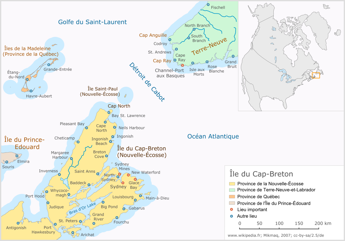
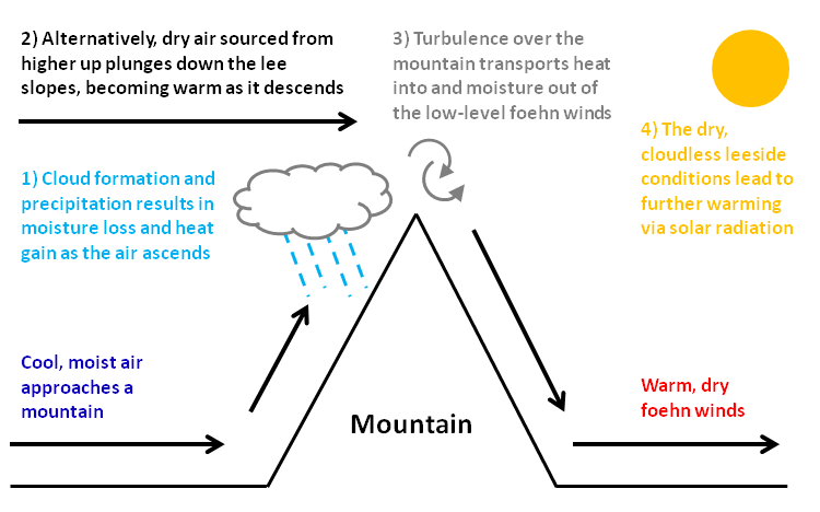
Suetes, ''suêtes'', ''les suêtes'', are strong south-east foehn winds on the west coast of Cape Breton Island. The term "suête" originates from the Acadian French inhabitants of the Chéticamp area as a contraction of "sud est" (south-east). The western edge of the Cape Breton Highlands The Cape Breton Highlands (french: Plateau du Cap-Breton, gd, Àrd-thalamh Cheap Bhreatainn), commonly called the Highlands, refer to a highland or mountainous plateau across the northern part of Cape Breton Island in the Canadian province of N ... plateau slopes abruptly down to sea level from approximately altitude. South-easterly winds lift on the east side of the island and flow across the plateau, frequently accelerating to high velocities on the steep downslope in stable airmass condition. The weather station at Grand Etang has recorded wind speeds of over on several occasions. References External links * Suetes winds on youtube Föhn effect Inverness County, Nova Scotia ... [...More Info...] [...Related Items...] OR: [Wikipedia] [Google] [Baidu] |
Grand Étang, Nova Scotia
Grand Étang is a small community in the Canada, Canadian province of Nova Scotia, located in Inverness County, Nova Scotia, Inverness County on Cape Breton Island. Grand Étang is noted for its periodic high wind events called Suetes, Les Suêtes. It is also the location of Nova Scotia's first wind energy project, which was established in 2002. Climate In August 2020, Grand Étang had four days where the temperature did not fall below 20.2 Celsius. On August 12, 2020, the overnight low was 23.3 Celsius. In 2018, the average daily temperature for August was 21.2 Celsius. Theoretically, in order to qualify for a humid subtropical climate (Cfa), Grand Étang would need an average daily temperature of 22 Celsius or higher in the warmest month (August) averaged over a 30-year period, and the average temperature in the coldest month would have to be -3 or warmer. Many areas of Nova Scotia are predicted to transition to a humid subtropical climate for the 30-year period of 2071-2100. ... [...More Info...] [...Related Items...] OR: [Wikipedia] [Google] [Baidu] |
Ile Du Cap-Breton
*
*
{{disambiguation ...
Ile may refer to: * iLe, a Puerto Rican singer * Ile District (other), multiple places * Ilé-Ifẹ̀, an ancient Yoruba city in south-western Nigeria * Interlingue (ISO 639:ile), a planned language * Isoleucine, an amino acid * Another name for Ilargi, the moon in Basque mythology * Historical spelling of Islay, Scottish island and girls' name * Another name for the Ili River in eastern Kazakhstan * ''Ile'', a gender-neutral pronoun in Portuguese See also * ILE (other) Ile may refer to: * iLe, a Puerto Rican singer * Ile District (other), multiple places * Ilé-Ifẹ̀, an ancient Yoruba city in south-western Nigeria * Interlingue (ISO 639:ile), a planned language * Isoleucine, an amino acid * Another ... [...More Info...] [...Related Items...] OR: [Wikipedia] [Google] [Baidu] |
Foehn Wind
A Foehn or Föhn (, , ), is a type of dry, relatively warm, downslope wind that occurs in the lee (downwind side) of a mountain range. It is a rain shadow wind that results from the subsequent adiabatic warming of air that has dropped most of its moisture on windward slopes (see orographic lift). As a consequence of the different adiabatic lapse rates of moist and dry air, the air on the leeward slopes becomes warmer than equivalent elevations on the windward slopes. Foehn winds can raise temperatures by as much as 14 °C (25 °F) in just a matter of hours. Switzerland, southern Germany and Austria have a warmer climate due to the Foehn, as moist winds off the Mediterranean Sea blow over the Alps. Etymology The name ''Foehn'' (german: Föhn, ) arose in the Alpine region. Originating from Latin ''(ventus) favonius'', a mild west wind of which Favonius was the Roman personification and probably transmitted by rm, favuogn or just ''fuogn'', the term was adopted as ... [...More Info...] [...Related Items...] OR: [Wikipedia] [Google] [Baidu] |
Cape Breton Island
Cape Breton Island (french: link=no, île du Cap-Breton, formerly '; gd, Ceap Breatainn or '; mic, Unamaꞌki) is an island on the Atlantic coast of North America and part of the province of Nova Scotia, Canada. The island accounts for 18.7% of Nova Scotia's total area. Although the island is physically separated from the Nova Scotia peninsula by the Strait of Canso, the long Canso Causeway connects it to mainland Nova Scotia. The island is east-northeast of the mainland with its northern and western coasts fronting on the Gulf of Saint Lawrence with its western coast forming the eastern limits of the Northumberland Strait. The eastern and southern coasts front the Atlantic Ocean with its eastern coast also forming the western limits of the Cabot Strait. Its landmass slopes upward from south to north, culminating in the highlands of its northern cape. One of the world's larger saltwater lakes, ("Arm of Gold" in French), dominates the island's centre. The total population ... [...More Info...] [...Related Items...] OR: [Wikipedia] [Google] [Baidu] |
Acadian French
Acadian French (french: français acadien, acadjonne) is a variety of French spoken by Acadians, mostly in the region of Acadia (region), Acadia, Canada. Acadian French has 7 regional accents, including chiac and brayon. Phonology Since there was relatively little linguistic contact with France from the late 18th century to the 20th century, Acadian French retained features that died out during the French standardization efforts of the 19th century such as these: * The phoneme, Acadian French has retained an alveolar trill or an alveolar flap, but modern speakers pronounce it as in Parisian French: (red) can be pronounced , or . * In nonstandard Acadian French, the third-person plural ending of verbs ‹›, such as (they eat), is still pronounced, unlike standard French (France and Quebec) ( (France)/ or (Quebec)/ ), the ‹e› can be pronounced or not, but ‹-nt› is always silent. According to Wiesmath (2006), some characteristics of Acadian are: *The verbal ending ... [...More Info...] [...Related Items...] OR: [Wikipedia] [Google] [Baidu] |
Cape Breton Highlands
The Cape Breton Highlands (french: Plateau du Cap-Breton, gd, Àrd-thalamh Cheap Bhreatainn), commonly called the Highlands, refer to a highland or mountainous plateau across the northern part of Cape Breton Island in the Canadian province of Nova Scotia. Considered an extension of the Appalachian mountain chain, the Highlands comprise the northern portions of Inverness and Victoria counties. The Highlands are surrounded by water with the Atlantic Ocean on the east, the Cabot Strait to the north and east, the Gulf of St. Lawrence on the north and west, and Bras d'Or Lake to the south. Elevations average 350 metres at the edges of the plateau (i.e. at the above-mentioned water bodies), and rise to more than 500 metres at the centre, including the highest elevation point in the province at White Hill, at 533 metres. The plateau consists of numerous broad, gently rolling hills bisected with deep valleys and steep-walled river canyons. The southern and western edges of the p ... [...More Info...] [...Related Items...] OR: [Wikipedia] [Google] [Baidu] |
Föhn Effect
A Foehn or Föhn (, , ), is a type of dry, relatively warm, downslope wind that occurs in the lee (downwind side) of a mountain range. It is a rain shadow wind that results from the subsequent adiabatic warming of air that has dropped most of its moisture on windward slopes (see orographic lift). As a consequence of the different adiabatic lapse rates of moist and dry air, the air on the leeward slopes becomes warmer than equivalent elevations on the windward slopes. Foehn winds can raise temperatures by as much as 14 °C (25 °F) in just a matter of hours. Switzerland, southern Germany and Austria have a warmer climate due to the Foehn, as moist winds off the Mediterranean Sea blow over the Alps. Etymology The name ''Foehn'' (german: Föhn, ) arose in the Alpine region. Originating from Latin ''(ventus) favonius'', a mild west wind of which Favonius was the Roman personification and probably transmitted by rm, favuogn or just ''fuogn'', the term was adopted as go ... [...More Info...] [...Related Items...] OR: [Wikipedia] [Google] [Baidu] |
Inverness County, Nova Scotia
Inverness County is an historical county and census division of Nova Scotia, Canada. Local government is provided by the Municipality of the County of Inverness, the town of Port Hawkesbury and the Whycocomagh 2 Waycobah First Nation reserve. History Established as the County of Juste au Corps in 1835, Inverness County was given its present name in 1837. It was named after Sir Cameron Inverness of Scotland, the land from which many of the early settlers came. Agriculture and fishing dominated the economy with exports of butter and cattle to Newfoundland and Halifax for most of the nineteenth century. The construction of the Inverness and Richmond Railway in 1901, and the subsequent opening of coal mines at Port Hood, Mabou, and Inverness, created the "only home market" local farmers had ever had. The boundaries of Inverness County had been previously defined when Cape Breton Island was divided by statute into three districts in 1823. In 1996, the county was amalgamated into a ... [...More Info...] [...Related Items...] OR: [Wikipedia] [Google] [Baidu] |
Mountain Meteorology
A mountain is an elevated portion of the Earth's crust, generally with steep sides that show significant exposed bedrock. Although definitions vary, a mountain may differ from a plateau in having a limited summit area, and is usually higher than a hill, typically rising at least 300 metres (1,000 feet) above the surrounding land. A few mountains are isolated summits, but most occur in mountain ranges. Mountains are formed through tectonic forces, erosion, or volcanism, which act on time scales of up to tens of millions of years. Once mountain building ceases, mountains are slowly leveled through the action of weathering, through slumping and other forms of mass wasting, as well as through erosion by rivers and glaciers. High elevations on mountains produce colder climates than at sea level at similar latitude. These colder climates strongly affect the ecosystems of mountains: different elevations have different plants and animals. Because of the less hospitable terrain and ... [...More Info...] [...Related Items...] OR: [Wikipedia] [Google] [Baidu] |


