|
Sturge Island
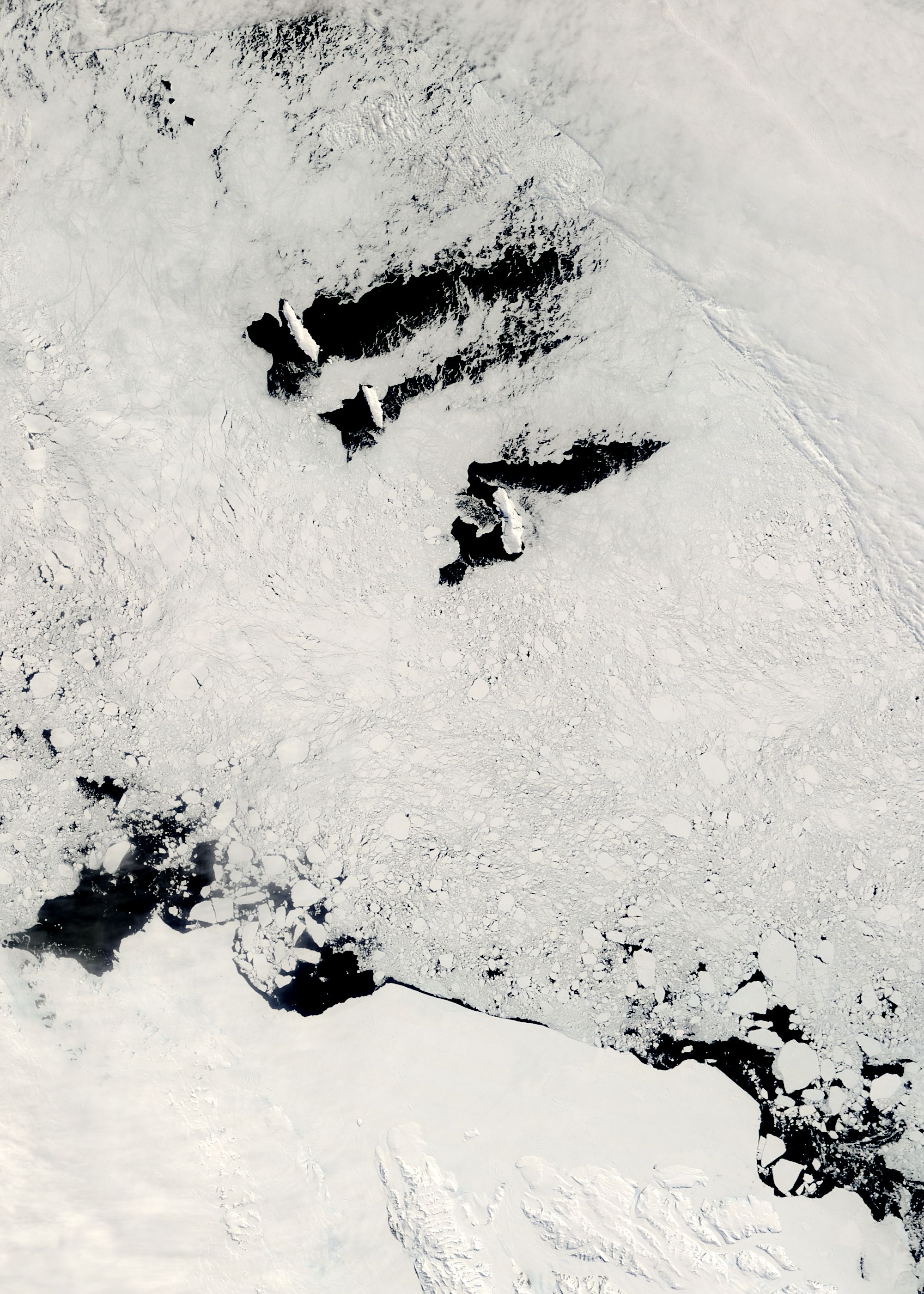
Sturge Island is one of the three main islands in the uninhabited Balleny Islands group located in the Southern Ocean. It lies southeast of Buckle Island and north-east of Belousov Point on the Antarctic mainland. The island, in Oates Land, also forms part of the Ross Dependency, claimed by New Zealand. Description The island is roughly a parallelogram in shape, with long east and west coasts and shorter coasts facing north-west and south-east. Of volcanic origin, it is about in width, with a maximum length of , between Cape Freeman in the north and Cape Smyth in the south. It is mostly covered by ice and snow throughout the year. The island's highest point reaches with the unclimbed stratovolcano Brown Peak, the highest point in the Balleny chain. Discovery and naming The Balleny Islands were discovered by British mariner John Balleny in 1839. Sturge Island was named after Thomas Sturge, one of the London merchants who had financed Balleny's expedition. Important Bird ... [...More Info...] [...Related Items...] OR: [Wikipedia] [Google] [Baidu] |
Balleny Islands
The Balleny Islands () are a series of uninhabited islands in the Southern Ocean extending from 66°15' to 67°35'S and 162°30' to 165°00'E. The group extends for about in a northwest-southeast direction. The islands are heavily glaciated and of volcanic origin. Glaciers project from their slopes into the sea. The islands were formed by the so-called Balleny hotspot. The group includes three main islands: Young, Buckle and Sturge, which lie in a line from northwest to southeast, and several smaller islets and rocks: *northeast of Young Island: Seal Rocks, Pillar *southeast of Young Island: Row Island, Borradaile Island (with Swan Base shelter hut) *south of Buckle Island: Scott Cone, Chinstrap Islet, Sabrina Islet (with Sabrina Refuge shelter hut), and the Monolith The islands are claimed by New Zealand as part of the Ross Dependency (see Territorial claims in Antarctica). Islands and rocks from north to south The islands' area totals and the highest point has been ... [...More Info...] [...Related Items...] OR: [Wikipedia] [Google] [Baidu] |
Thomas Sturge
Thomas Sturge (1787–1866) was a British oil merchant, shipowner, cement manufacturer, railway company director, social reformer and philanthropist. Family background and early life Thomas Sturge was born in 1787, one of at least ten children of Thomas Sturge the elder (1749–1825), tallow chandler and oil merchant of Newington Butts, about a mile south of London Bridge. Thomas the younger joined his father's business early in the 19th century, as did at least three of his brothers, Nathan, George and Samuel. Thomas Sturge & Sons, oil merchants and spermaceti processors operated from premises near Elephant and Castle, Newington Butts, until 1840. He was a first cousin of social reformer and philanthropist Joseph Sturge. Oil merchant and shipowner Thomas Sturge junior had become the senior partner in the business by 1816, when he began to buy ships and send them to the Southern Whale Fishery to obtain whale oil, seal oil and spermaceti for processing and sale in London ... [...More Info...] [...Related Items...] OR: [Wikipedia] [Google] [Baidu] |
Important Bird Areas Of Antarctica
Importance is a property of entities that matter or make a difference. For example, World War II was an important event and Albert Einstein was an important person because of how they affected the world. There are disagreements in the academic literature about what type of difference is required. According to the causal impact view, something is important if it has a big causal impact on the world. This view is rejected by various theorists, who insist that an additional aspect is required: that the impact in question makes a value difference. This is often understood in terms of how the important thing affects the well-being of people. So on this view, World War II was important, not just because it brought about many wide-ranging changes but because these changes had severe negative impacts on the well-being of the people involved. The difference in question is usually understood counterfactually as the contrast between how the world actually is and how the world would have bee ... [...More Info...] [...Related Items...] OR: [Wikipedia] [Google] [Baidu] |
American Geophysical Union
The American Geophysical Union (AGU) is a 501(c)(3) nonprofit organization of Earth, atmospheric, ocean, hydrologic, space, and planetary scientists and enthusiasts that according to their website includes 130,000 people (not members). AGU's activities are focused on the organization and dissemination of scientific information in the interdisciplinary and international fields within the Earth and space sciences. The geophysical sciences involve four fundamental areas: atmospheric and ocean sciences; solid-Earth sciences; hydrologic sciences; and space sciences. The organization's headquarters is located on Florida Avenue in Washington, D.C. History The AGU was established in December 1919 by the National Research Council (NRC) to represent the United States in the International Union of Geodesy and Geophysics (IUGG), and its first chairman was William Bowie of the United States Coast and Geodetic Survey (USCGS). For more than 50 years, it operated as an unincorporated affili ... [...More Info...] [...Related Items...] OR: [Wikipedia] [Google] [Baidu] |
Antarctic Treaty
russian: link=no, Договор об Антарктике es, link=no, Tratado Antártico , name = Antarctic Treaty System , image = Flag of the Antarctic Treaty.svgborder , image_width = 180px , caption = Flag of the Antarctic Treaty System , type = Condominium , date_drafted = , date_signed = December 1, 1959"Antarctic Treaty" in ''The New Encyclopædia Britannica''. Chicago: Encyclopædia Britannica Inc., 15th edn., 1992, Vol. 1, p. 439. , location_signed = Washington, D.C., United States , date_sealed = , date_effective = June 23, 1961 , condition_effective = Ratification of all 12 signatories , date_expiration = , signatories = 12 , parties = 55 , depositor = Federal government of the United States , languages = English, French, Russian, and Spanish , wikisource = Antarctic Treaty The Antarctic Treaty a ... [...More Info...] [...Related Items...] OR: [Wikipedia] [Google] [Baidu] |
Composite Antarctic Gazetteer
The Composite Gazetteer of Antarctica (CGA) of the Scientific Committee on Antarctic Research (SCAR) is the authoritative international gazetteer containing all Antarctic toponyms published in national gazetteers, plus basic information about those names and the relevant geographical features. The Gazetteer includes also parts of the International Hydrographic Organization (IHO) General Bathymetric Chart of the Oceans (GEBCO) gazetteer for under-sea features situated south of 60° south latitude. , the overall content of the CGA amounts to 37,893 geographic names for 19,803 features including some 500 features with two or more entirely different names, contributed by the following sources: {, class="wikitable sortable" ! Country ! Names , - , United States , 13,192 , - , United Kingdom , 5,040 , - , Russia , 4,808 , - , New Zealand , 2,597 , - , Australia , 2,551 , - , Argentina , 2,545 , - , Chile , 1,866 , - , Norway , 1,706 , - , Bulgaria , 1,450 , - , G ... [...More Info...] [...Related Items...] OR: [Wikipedia] [Google] [Baidu] |
Cape Frances
Cape Frances () is a cape on the east side of Sturge Island in the Balleny Islands. In 1841, Captain James C. Ross Sir James Clark Ross (15 April 1800 – 3 April 1862) was a British Royal Navy officer and polar explorer known for his explorations of the Arctic, participating in two expeditions led by his uncle John Ross, and four led by William Edwa ..., viewing Sturge Island from a considerable distance, thought it a group of three islands and named the center island, Frances. This error was discovered in 1904 by Captain Robert F. Scott, who applied the name to this cape. References Headlands of the Balleny Islands {{subantarctic-geo-stub ... [...More Info...] [...Related Items...] OR: [Wikipedia] [Google] [Baidu] |
Snow Petrel
The snow petrel (''Pagodroma nivea'') is the only member of the genus ''Pagodroma.'' It is one of only three birds that has been seen at the Geographic South Pole, along with the Antarctic petrel and the south polar skua, which have the most southerly breeding sites of any bird, inland in Antarctica. Taxonomy The snow petrel was described in 1777 by the German naturalist Georg Forster in his book ''A Voyage Round the World''. He had accompanied James Cook on Cook's second voyage to the Pacific. We particularly observed a petrel, about the size of a pigeon, entirely white, with a black bill and blueish feet; it constantly appeared about the icy masses, and may be looked upon as a sure fore-runner of ice. Forster placed the snow petrel in the genus ''Procellaria'' that had been erected for the petrels by Carl Linnaeus in 1758 and coined the binomial name ''Procellaria nivea''. The snow petrel is now the only species placed in the genus ''Pagodroma'' that was introduced for the ... [...More Info...] [...Related Items...] OR: [Wikipedia] [Google] [Baidu] |
Southern Fulmar
The southern fulmar (''Fulmarus glacialoides'') is a seabird of the Southern Hemisphere. Along with the northern fulmar, ''F. glacialis'', it belongs to the fulmar genus ''Fulmarus'' in the family Procellariidae, the true petrels. It is also known as the Antarctic fulmar or silver-grey fulmar. It is largely pale grey above and white below with a distinctive white patch on the wing. It breeds on the coast of Antarctica and on surrounding islands, moving north in winter. It nests in colonies on cliffs, laying a single egg on a ledge or crevice. Its diet includes krill, fish and squid picked from the water's surface. Taxonomy The southern fulmar formally described and illustrated in 1840 by the Scottish zoologist Andrew Smith in his major work ''Illustrations of the Zoology of South Africa''. He placed it with all the other petrels in the genus ''Procellaria'' and coined the binomial name ''Procellaria glacialoides''. The southern fulmar is now placed with the northern fulmar in ... [...More Info...] [...Related Items...] OR: [Wikipedia] [Google] [Baidu] |
BirdLife International
BirdLife International is a global partnership of non-governmental organizations that strives to conserve birds and their habitats. BirdLife International's priorities include preventing extinction of bird species, identifying and safeguarding important sites for birds, maintaining and restoring key bird habitats, and empowering conservationists worldwide. It has a membership of more than 2.5 million people across 116 country partner organizations, including the Royal Society for the Protection of Birds, the Wild Bird Society of Japan, the National Audubon Society and American Bird Conservancy. BirdLife International has identified 13,000 Important Bird and Biodiversity Areas and is the official International Union for Conservation of Nature’s Red List authority for birds. As of 2015, BirdLife International has established that 1,375 bird species (13% of the total) are threatened with extinction ( critically endangered, endangered or vulnerable). BirdLife International p ... [...More Info...] [...Related Items...] OR: [Wikipedia] [Google] [Baidu] |
Important Bird Area
An Important Bird and Biodiversity Area (IBA) is an area identified using an internationally agreed set of criteria as being globally important for the conservation of bird populations. IBA was developed and sites are identified by BirdLife International. There are over 13,000 IBAs worldwide. These sites are small enough to be entirely conserved and differ in their character, habitat or ornithological importance from the surrounding habitat. In the United States the Program is administered by the National Audubon Society. Often IBAs form part of a country's existing protected area network, and so are protected under national legislation. Legal recognition and protection of IBAs that are not within existing protected areas varies within different countries. Some countries have a National IBA Conservation Strategy, whereas in others protection is completely lacking. History In 1985, following a specific request from the European Economic Community, Birdlife International ... [...More Info...] [...Related Items...] OR: [Wikipedia] [Google] [Baidu] |


