|
Stanton, California
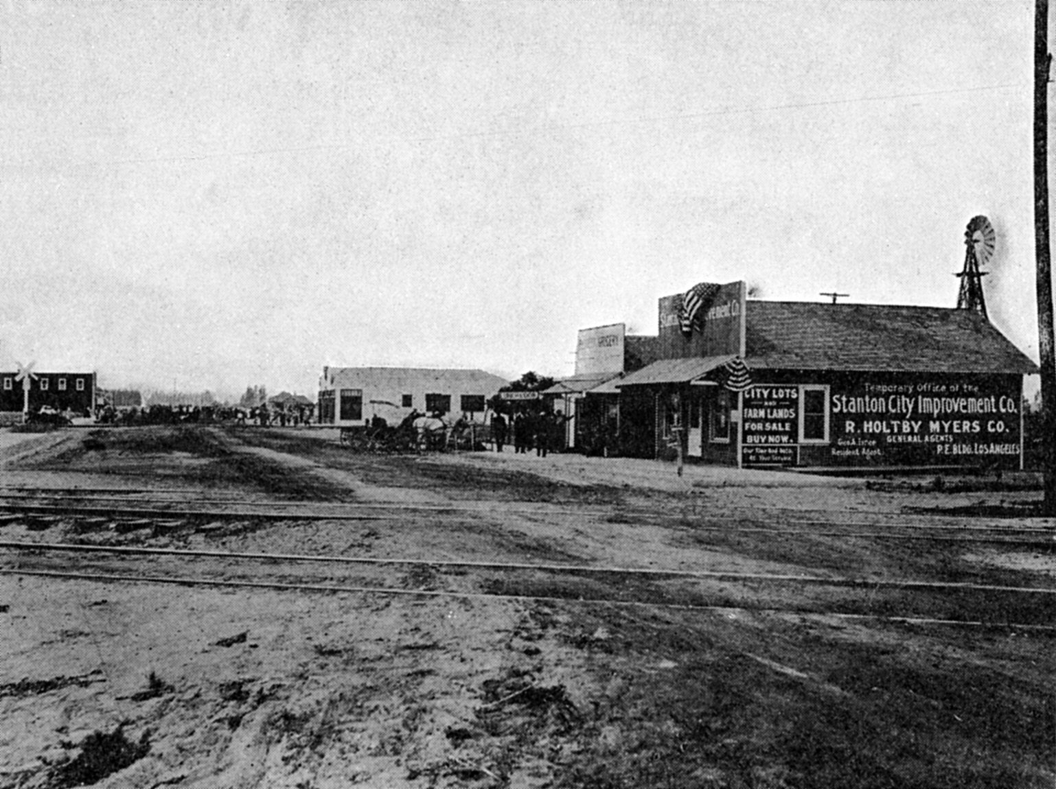
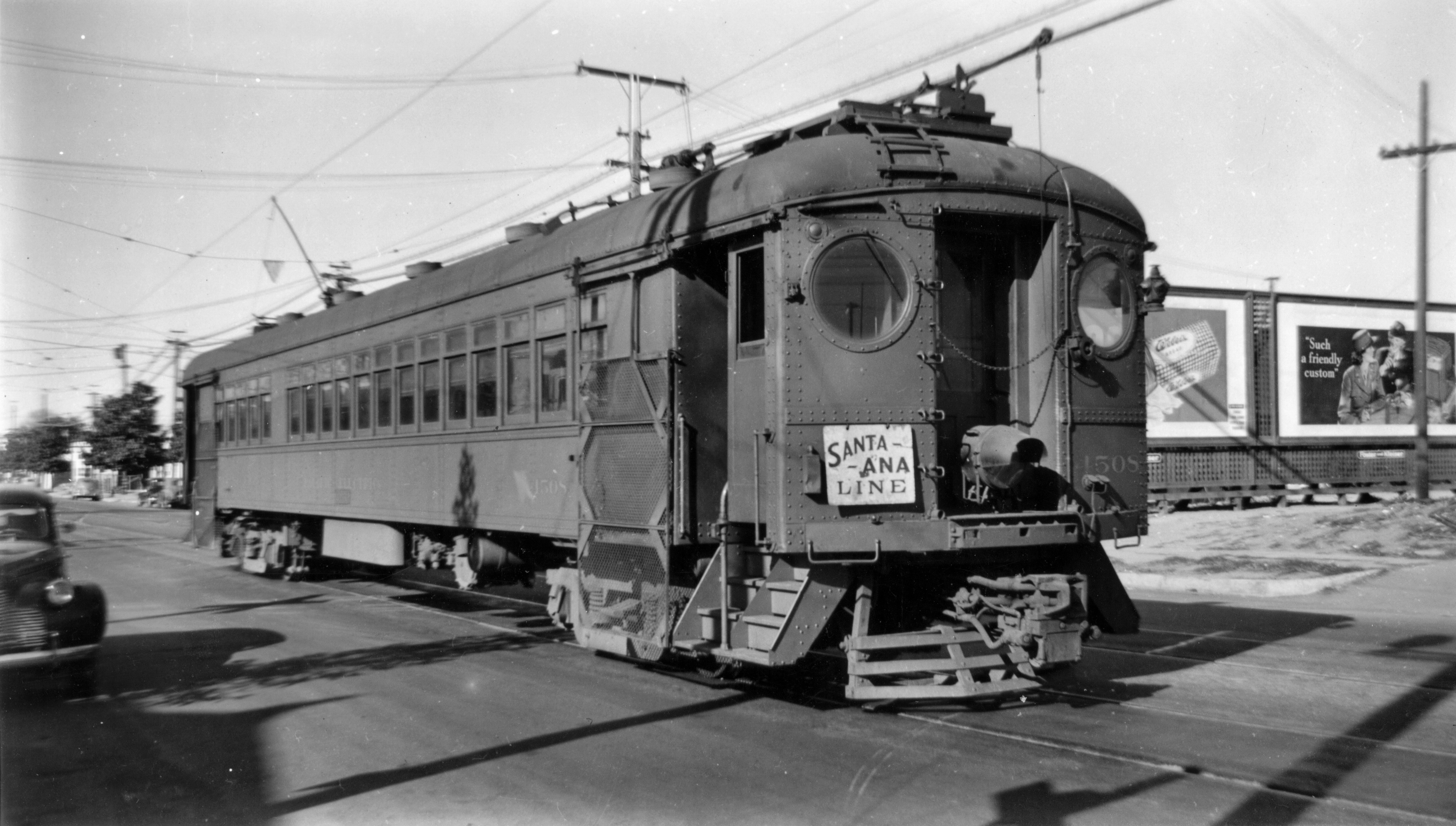
Stanton is a city in northern Orange County, California, part of the Los Angeles metropolitan area. The population was 37,962 at the 2020 United States Census. The city was incorporated in 1956 and operates under the council–manager form of government, providing a full range of municipal services. Stanton is bounded by Cypress on the west, Anaheim on the north, and east, and Garden Grove on the east and south. History On November 4, 1905, the Los Angeles Interurban Railway started service on the ''Santa Ana Line''. It ran along an almost perfectly straight line between Watts and Santa Ana. Access to transportation allowed the population of the rural area to grow. This area is now Stanton and West Anaheim. Stanton was named for Philip A. Stanton, a Republican assemblyman for Los Angeles from 1903 to 1909. In 1908, the privately owned Pacific Electric Railway leased the Santa Ana Line and took over the service, extending its regional light-rail system. By 1928, the impress ... [...More Info...] [...Related Items...] OR: [Wikipedia] [Google] [Baidu] |
List Of Municipalities In California
California is a U.S. state, state located in the Western United States. It is the List of U.S. states and territories by population, most populous state and the List of U.S. states and territories by area, third largest by area after Alaska and Texas. According to the 2020 United States Census, California has 39,538,223 inhabitants and of land. California has been inhabited by numerous Indigenous peoples of California, Native American peoples since antiquity. The Spanish colonization of the Americas, Spanish, the Russian colonization of the Americas, Russians, and other Europeans began exploring and colonizing the area in the 16th and 17th centuries, with the Spanish establishing its first California Spanish missions in California, mission at what is now Presidio of San Diego, San Diego in 1769. After the Mexican Cession of 1848, the California Gold Rush brought worldwide attention to the area. The growth of the Cinema of the United States, movie industry in Los Angeles, high te ... [...More Info...] [...Related Items...] OR: [Wikipedia] [Google] [Baidu] |
Downtown Stanton, California, 1913
''Downtown'' is a term primarily used in North America by English speakers to refer to a city's sometimes commercial, cultural and often the historical, political and geographic heart. It is often synonymous with its central business district (CBD). Downtowns typically contain a small percentage of a city’s employment. In some metropolitan areas it is marked by a cluster of tall buildings, cultural institutions and the convergence of rail transit and bus lines. In British English, the term " city centre" is most often used instead. History Origins The Oxford English Dictionary's first citation for "down town" or "downtown" dates to 1770, in reference to the center of Boston. Some have posited that the term "downtown" was coined in New York City, where it was in use by the 1830s to refer to the original town at the southern tip of the island of Manhattan.Fogelson, p. 10. As the town of New York grew into a city, the only direction it could grow on the island was toward the ... [...More Info...] [...Related Items...] OR: [Wikipedia] [Google] [Baidu] |
Salient (geography)
A salient (also known as a panhandle or bootheel) is an elongated protrusion of a geopolitical entity, such as a subnational entity or a sovereign state. While similar to a peninsula in shape, a salient is most often not surrounded by water on three sides. Instead, it has a land border on at least two sides and extends from the larger geographical body of the administrative unit. In American English, the term panhandle is often used to describe a relatively long and narrow salient, such as the westernmost extensions of Florida and Oklahoma. Another term is bootheel, used for the Missouri Bootheel and New Mexico Bootheel areas. Origin The term ''salient'' is derived from military salients. The term "panhandle" derives from the analogous part of a cooking pan, and its use is generally confined to North America. The salient shape can be the result of arbitrarily drawn international or subnational boundaries, though the location of administrative borders can also take into acco ... [...More Info...] [...Related Items...] OR: [Wikipedia] [Google] [Baidu] |
California State Route 39
State Route 39 (SR 39) is a state highway in the U.S. state of California that travels through Orange and Los Angeles counties. Its southern terminus is at Pacific Coast Highway ( SR 1), in Huntington Beach. SR 39's northern terminus is at Islip Saddle on Angeles Crest Highway ( SR 2) in the Angeles National Forest, but its northernmost segment (including the connection with SR 2) has been closed to the public since 1978 due to a massive mud and rockslide. It would cost a total of $100 million USD to repair the road. Officially, the highway is broken into pieces. Caltrans has not adopted or signed the segment between La Habra and West Covina. Caltrans has also relinquished a portion of SR 39 in Buena Park from Stanton Avenue in Buena Park to Interstate 5 in 2013, as well as those segments within the cities of Azusa by 2010, Covina by 2010, and West Covina by 2013. Since 2001, a portion of SR 39 that runs through the city of Stanton has been considered for ... [...More Info...] [...Related Items...] OR: [Wikipedia] [Google] [Baidu] |
Orange County Transportation Authority
The Orange County Transportation Authority (OCTA) is the transportation planning commission for Orange County, California in the Los Angeles metropolitan area. OCTA is responsible for funding and implementing transit and capital projects for the transportation system for the travel needs, including freeway improvements, express lane management, bus and rail transit operation, and commuter rail oversight. OCTA was founded in 1991 through the consolidation of seven separate transportation agencies and is governed by a 17-member Board of Directors with the Caltrans District Director serving in a non-voting capacity. The Authority's administrative offices are located in the City of Orange. History OCTA's predecessor agency, the Orange County Transit District, was created in August 1972 by a referendum of county voters. It originally started as Santa Ana Transit, a small transit agency with five bus routes operating in Orange County. Santa Ana Transit later merged with other, smal ... [...More Info...] [...Related Items...] OR: [Wikipedia] [Google] [Baidu] |
Pacific Electric Railway
The Pacific Electric Railway Company, nicknamed the Red Cars, was a privately owned mass transit system in Southern California consisting of electrically powered streetcars, interurban cars, and buses and was the largest electric railway system in the world in the 1920s. Organized around the city centers of Los Angeles and San Bernardino, it connected cities in Los Angeles County, Orange County, San Bernardino County and Riverside County. The system shared dual gauge track with the narrow gauge Los Angeles Railway, "Yellow Car," or "LARy" system on Main Street in downtown Los Angeles (directly in front of the 6th and Main terminal), on 4th Street, and along Hawthorne Boulevard south of downtown Los Angeles toward the cities of Hawthorne, Gardena, and Torrance. Districts The system had four districts: * Northern District: San Gabriel Valley, including Pasadena, Mount Lowe, South Pasadena, Alhambra, El Monte, Covina, Duarte, Glendora, Azusa, Sierra Madre, and Monrovia. * ... [...More Info...] [...Related Items...] OR: [Wikipedia] [Google] [Baidu] |
Los Angeles
Los Angeles ( ; es, Los Ángeles, link=no , ), often referred to by its initials L.A., is the largest city in the state of California and the second most populous city in the United States after New York City, as well as one of the world's most populous megacities. Los Angeles is the commercial, financial, and cultural center of Southern California. With a population of roughly 3.9 million residents within the city limits , Los Angeles is known for its Mediterranean climate, ethnic and cultural diversity, being the home of the Hollywood film industry, and its sprawling metropolitan area. The city of Los Angeles lies in a basin in Southern California adjacent to the Pacific Ocean in the west and extending through the Santa Monica Mountains and north into the San Fernando Valley, with the city bordering the San Gabriel Valley to it's east. It covers about , and is the county seat of Los Angeles County, which is the most populous county in the United States with an estim ... [...More Info...] [...Related Items...] OR: [Wikipedia] [Google] [Baidu] |
Republican Party (United States)
The Republican Party, also referred to as the GOP ("Grand Old Party"), is one of the two major contemporary political parties in the United States. The GOP was founded in 1854 by anti-slavery activists who opposed the Kansas–Nebraska Act, which allowed for the potential expansion of chattel slavery into the western territories. Since Ronald Reagan's presidency in the 1980s, conservatism has been the dominant ideology of the GOP. It has been the main political rival of the Democratic Party since the mid-1850s. The Republican Party's intellectual predecessor is considered to be Northern members of the Whig Party, with Republican presidents Abraham Lincoln, Rutherford B. Hayes, Chester A. Arthur, and Benjamin Harrison all being Whigs before switching to the party, from which they were elected. The collapse of the Whigs, which had previously been one of the two major parties in the country, strengthened the party's electoral success. Upon its founding, it supported c ... [...More Info...] [...Related Items...] OR: [Wikipedia] [Google] [Baidu] |
Santa Ana, California
Santa Ana () is the second most populous city and the county seat of Orange County, California. Located in the Greater Los Angeles region of Southern California, the city's population was 310,227 at the 2020 census, making Santa Ana the List of California cities by population, 13th-most populous city in California and the List of United States cities by population density, 4th densest large city in the United States (behind only New York City, San Francisco, and Boston). Santa Ana is a major regional economic and cultural hub for the Orange Coast. Santa Ana's origins began in 1810, when the Spanish governor of California granted Rancho Santiago de Santa Ana to José Antonio Yorba. Following the Mexican War of Independence, the Yorba family ranchos of California, rancho was enlarged, becoming one of the largest and most valuable in the region and home to a diverse Californio community. Following the American Conquest of California, the rancho was sold to the Sepúlveda family, wh ... [...More Info...] [...Related Items...] OR: [Wikipedia] [Google] [Baidu] |
Watts, Los Angeles
Watts is a neighborhood in southern Los Angeles, California. It is located within the South Los Angeles region, bordering the cities of Lynwood, Huntington Park and South Gate to the east and southeast, respectively, and the unincorporated community of Willowbrook to the south. Founded in the late nineteenth century as a ranching community, the arrival of the railroads and the construction of Watts Station saw the rapid development of Watts as an independent city, but in 1926 it was consolidated with Los Angeles. By the 1940s, Watts transformed into a primarily working class African-American neighborhood, but from the 1960s developed a reputation as a low-income, high-crime area, following the Watts riots and the increasing influence of street gangs. Watts has become a predominantly Hispanic neighborhood with a significant African American minority, and remains one of the most impoverished neighborhoods in Los Angeles despite falling crime rates since the 1990s. Notable civic ... [...More Info...] [...Related Items...] OR: [Wikipedia] [Google] [Baidu] |
Santa Ana Line
The Santa Ana Line was an interurban railway route connecting Los Angeles and Santa Ana in Orange County. It ran between 1905 and 1958 (with the southern end truncated to Bellflower in 1950) and was predominantly operated by the Pacific Electric Railway for its history. History The route began operation on November 6, 1905 under the Los Angeles Inter-Urban Electric Railway; Pacific Electric leased the line starting in 1908 and fully acquired it in 1911 under terms of the Great Merger. The Santa Ana Line was designated as route number 11 during most of its operational life. Santa Ana's status as the county seat and largest city in Orange County at the time allowed for high ridership. The railway built a new station in the city in late 1927, and cars were rerouted to serve it. Cars ceased running to the Santa Ana Southern Pacific Depot in November 1945. By 1950, service had halved from its peak only five years earlier and the line was cut back to a minor station in Bellflo ... [...More Info...] [...Related Items...] OR: [Wikipedia] [Google] [Baidu] |
Garden Grove, California
Garden Grove is a city in northern Orange County, California, United States, located just southwest of Disneyland (located in Anaheim, CA). The population was 171,949 at the 2020 census. State Route 22, also known as the Garden Grove Freeway, passes through the city in an east–west direction. The western portion of the city is known as West Garden Grove. History 19th century Garden Grove was founded by Alonzo Cook in 1874. A school district and Methodist church were organized that year. It remained a small rural crossroads and farming community until the arrival of the Pacific Electric Railroad in 1905. The rail connection helped the town prosper with the influx of tourists, visitors and eventually settlers, and it was noted for its crops of oranges, walnuts, chili peppers and later strawberries. 20th century In 1933, much of the town's central business district was destroyed by the Long Beach earthquake, and one person was killed at the high school. The post-World War ... [...More Info...] [...Related Items...] OR: [Wikipedia] [Google] [Baidu] |


.jpg)