|
Stanningfield
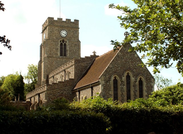
Stanningfield is a village and former civil parish, since 1988 in the parish of Bradfield Combust with Stanningfield, in the West Suffolk district of the county of Suffolk, England. The village lies just off of the A134 road, about 5 miles (8 km) south-east of Bury St Edmunds, 5 miles/8 km north-west of Lavenham, and 10 miles/16 km north of Sudbury. Governance Stanningfield belongs to the West Suffolk district of the shire county of Suffolk. The three tiers of local government are Suffolk County Council, St Edmundsbury Borough Council and Bradfield Combust with Stanningfield Parish Council. The parish currently lacks a parish plan or design statement. History Stanningfield takes its name from the Early English name "Stanfella" or "Stansfelda" meaning "stony field". It is known that the area was occupied early in recorded British history as traces of Roman occupation has been found on one local farm. Occasional documentary references mention the village in Anglo-S ... [...More Info...] [...Related Items...] OR: [Wikipedia] [Google] [Baidu] |
Stanningfield Village Sign - Geograph
Stanningfield is a village and former civil parish, since 1988 in the parish of Bradfield Combust with Stanningfield, in the West Suffolk (district), West Suffolk district of the county of Suffolk, England. The village lies just off of the A134 road, about 5 miles (8 km) south-east of Bury St Edmunds, 5 miles/8 km north-west of Lavenham, and 10 miles/16 km north of Sudbury, Suffolk, Sudbury. Governance Stanningfield belongs to the West Suffolk (district), West Suffolk district of the shire county of Suffolk. The three tiers of local government are Suffolk County Council, St Edmundsbury Borough Council and Bradfield Combust with Stanningfield Parish Council. The parish currently lacks a parish plan or design statement. History Stanningfield takes its name from the Early English name "Stanfella" or "Stansfelda" meaning "stony field". It is known that the area was occupied early in recorded British history as traces of Roman occupation has been found on one local farm. Occas ... [...More Info...] [...Related Items...] OR: [Wikipedia] [Google] [Baidu] |
Coldham Hall
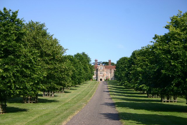
Coldham Hall is a Grade I listed building, built in 1574, that is located in the parish of Bradfield Combust with Stanningfield in Suffolk. The Hall is very close to the village of Lawshall, and part of the Coldham estate is located within this parish. Description Coldham Hall is a large Tudor English country house, country house that was constructed in 1574 for Sir Robert Rookwood (or Rokewood) of Stanningfield. A notable feature of this two-storey building is the great hall, with a long gallery in the roof space some 32 metres long, running from east to west. Internal alterations undertaken around 1770 include a Roman Catholic chapel with delicate plasterwork, leading from the long gallery. Mid-nineteenth century alterations, including loggias on the east and south side, are now removed, but various window alterations at the rear and a service wing at the north end remain. The house was restored around 1980. History Following its construction by Robert Rookwood in 1574 ... [...More Info...] [...Related Items...] OR: [Wikipedia] [Google] [Baidu] |
Bradfield Combust
Bradfield Combust (or Burnt Bradfield) is a village and former Manorialism, manor and civil parish, now in the parish of Bradfield Combust with Stanningfield in Suffolk, England, located on the A134 road, A134 between Windsor Green and Great Whelnetham. In 1961 the parish had a population of 108. In 1988 the parish was merged with Stanningfield to form "Bradfield Combust with Stanningfield". Origin of the name According to Swedish Professor of English at Lund University, Eilert Ekwall, the meaning of the village name of "Bradfield" is "the wide fold" (syn. Bradefeld, Bradfelda, Bradefelda). "Combust" is derived from "Combusta" Latin fem. = burnt or burned; medieval syn. "Brent". History Before Norman conquest of England, the Conquest, the manor was probably owned by Ulfcytel Snillingr, Ulfketel, Saxon King of the East Angles, who gave this part of his manor to the monks of St. Edmund, while reserving the lordship. The ''Domesday Book'' records the population of Bradefelda man ... [...More Info...] [...Related Items...] OR: [Wikipedia] [Google] [Baidu] |
Lawshall
Lawshall is a village and civil parish in Suffolk, England. Located around a mile off the A134 between Bury St Edmunds and Sudbury, it is part of Babergh district. The parish has nine settlements comprising the three main settlements of The Street, Lambs Lane and Bury Road along with the six small hamlets of Audley End, Hanningfield Green, Harrow Green, Hart's Green, Hibb's Green and Lawshall Green. Notable buildings in the parish include All Saints Church and Lawshall Hall. In addition Coldham Hall is very close to the village and part of the grounds of the estate are located within the parish. Other important features include Frithy Wood, which is classified as Ancient Woodland and a designated Site of Special Scientific Interest (SSSI), and The Warbanks historical site. Etymology The village was originally known as "Hlaw-gesella" which meant the shelter or hut on a hill or high ground. Early records indicate that in later years the name was recorded as "Laushella" ... [...More Info...] [...Related Items...] OR: [Wikipedia] [Google] [Baidu] |
Bradfield Combust With Stanningfield
Bradfield Combust with Stanningfield is a civil parish about 6 miles south of Bury St Edmunds, in the West Suffolk district of Suffolk, England. According to the 2001 census it had a population of 503, increasing to 578 at the Census 2011. The parish was formed in 1998 from Bradfield Combust and Stanningfield Stanningfield is a village and former civil parish, since 1988 in the parish of Bradfield Combust with Stanningfield, in the West Suffolk district of the county of Suffolk, England. The village lies just off of the A134 road, about 5 miles (8& .... References External links Bradfield Combust with Stanningfield Parish Council Civil parishes in Suffolk Borough of St Edmundsbury {{Suffolk-geo-stub ... [...More Info...] [...Related Items...] OR: [Wikipedia] [Google] [Baidu] |
Elizabeth Inchbald
Elizabeth Inchbald (née Simpson, 15 October 1753 – 1 August 1821) was an English novelist, actress, dramatist, and translator. Her two novels, '' A Simple Story'' and '' Nature and Art'', have received particular critical attention. Life Born on 15 October 1753 at Stanningfield, near Bury St Edmunds, Suffolk, Elizabeth was the eighth of the nine children of John Simpson (died 1761), a farmer, and his wife Mary, ''née'' Rushbrook. The family, like several others in the neighbourhood, was Roman Catholic. Her brother was sent to school, but Elizabeth and her sisters were educated at home. Inchbald had a speech impediment. Focused on acting from a young age, she worked hard to manage her stammer, but her family discouraged an attempt in early 1770 to gain a position at the Norwich Theatre. That same year her brother George became an actor. Still determined, Inchbald went to London to become an actress in April 1772 at the age of 18. It was a difficult beginning: some observer ... [...More Info...] [...Related Items...] OR: [Wikipedia] [Google] [Baidu] |
Ambrose Rookwood
Ambrose Rookwood (c. 1578 – 31 January 1606) was a member of the failed 1605 Gunpowder Plot, a conspiracy to replace the Protestant King James I with a Catholic sovereign. Rookwood was born into a wealthy family of Catholic recusants, and educated by Jesuits in Flanders. His older brother became a Franciscan, and his two younger brothers were ordained as Catholic priests. Rookwood became a horse-breeder. He married the Catholic Elizabeth Tyrwhitt, and had at least two sons. He was enlisted into the plot in September 1605 by Robert Catesby, a religious zealot whose impatience with James' treatment of English Catholics had grown so severe that he conspired to blow up the House of Lords with gunpowder, killing the king and much of the Protestant hierarchy. With the other conspirators he had recruited, Catesby also planned to incite a rebellion in the Midlands, during which James's nine-year-old daughter Princess Elizabeth would be captured, and installed as titular queen. Rookw ... [...More Info...] [...Related Items...] OR: [Wikipedia] [Google] [Baidu] |
Great Whelnetham
Great Whelnetham (sometimes Great Welnetham) is a village and civil parish in the West Suffolk district of Suffolk in eastern England. Located around two miles south of Bury St Edmunds, in 2005 its population was 820. The parish also contains the hamlet of Cocks Green, and the village of Sicklesmere, with which Great Whelnetham is contiguous. Until the Beeching Axe, the area was served by Welnetham railway station on the Long Melford-Bury St Edmunds branch line. In 2019, an excavation of an 4th-century Roman cemetery in Great Whelnetham uncovered unusual burial practices. Of 52 skeletons found, up to 40% had been decapitated, which archaeologists claimed gave new insight into Roman traditions. The burial ground includes the remains of men, women and children who likely lived in a nearby settlement. The decapitated skeletons represent "quite a rare find". History Demography According to the Office for National Statistics, at the time of the United Kingdom Census 2001 A ... [...More Info...] [...Related Items...] OR: [Wikipedia] [Google] [Baidu] |
Hawstead
Hawstead is a small village and civil parish in the West Suffolk (district), West Suffolk district of Suffolk in eastern England. It is located south of Bury St. Edmunds between the B1066 road, B1066 and A134 roads, in a fork formed by the River Lark and a small tributary. The place-name 'Hawstead' is first attested in the Domesday Book of 1086, where it appears as ''Haldsteada''. The name is thought to mean 'a place of shelter for cattle'. Hawstead Place, previously the seat of the Drury family, is now a farmhouse. William Drury (MP for Suffolk), Sir William Drury was High Sheriff of Suffolk, sheriff and knight of the shire for Suffolk (UK Parliament constituency), Suffolk. Lt Col Edward Robert Drury, son of Rev Sir William Drury, was the first General Manager and President of the Queensland Bank of Australia now the National Australia Bank; he named his Queensland home 'Hawstead' in 1875. Lady Drury's Closet (also known as the Hawstead Panels), now in Christchurch Mansion in ... [...More Info...] [...Related Items...] OR: [Wikipedia] [Google] [Baidu] |
Gunpowder Plot
The Gunpowder Plot of 1605, in earlier centuries often called the Gunpowder Treason Plot or the Jesuit Treason, was a failed assassination attempt against King James I by a group of provincial English Catholics led by Robert Catesby who sought to restore the Catholic monarchy to England after decades of persecution against Catholics. The plan was to blow up the House of Lords during the State Opening of Parliament on 5 November 1605, as the prelude to a popular revolt in the Midlands during which King James's nine-year-old daughter, Elizabeth, was to be installed as the Catholic head of state. Catesby may have embarked on the scheme after hopes of securing greater religious tolerance under King James I had faded, leaving many English Catholics disappointed. His fellow contributors were John and Christopher Wright, Robert and Thomas Wintour, Thomas Percy, Guy Fawkes, Robert Keyes, Thomas Bates, John Grant, Ambrose Rookwood, Sir Everard Digby and Francis Tresham. Fawkes, ... [...More Info...] [...Related Items...] OR: [Wikipedia] [Google] [Baidu] |
West Suffolk (district)
West Suffolk District is a Non-metropolitan district, local government district in Suffolk, England, which was established on 1 April 2019, following the merger of the existing Forest Heath district with the borough of Borough of St Edmundsbury, St Edmundsbury. The two councils had already had a joint Chief Executive since 2011. At the 2011 census, the two districts had a combined population of 170,756. It is currently controlled by the Conservative Party (UK), Conservative Party. The main towns in the new district are Bury St Edmunds, Newmarket, Suffolk, Newmarket, Brandon, Suffolk, Brandon, Haverhill, Suffolk, Haverhill and Mildenhall, Suffolk, Mildenhall. The district covers a smaller area compared to the former administrative county of West Suffolk (county), West Suffolk, which was abolished by the Local Government Act 1972. Communities The district council area is made up of 5 towns and 97 civil parishes, with the whole area being parished. Towns *Brandon, Suffolk, Brando ... [...More Info...] [...Related Items...] OR: [Wikipedia] [Google] [Baidu] |
Roman Catholicism
The Catholic Church, also known as the Roman Catholic Church, is the List of Christian denominations by number of members, largest Christian church, with 1.3 billion baptized Catholics Catholic Church by country, worldwide . It is among the world's oldest and largest international institutions, and has played a prominent role in the history and development of Western civilization.Gerald O'Collins, O'Collins, p. v (preface). The church consists of 24 Catholic particular churches and liturgical rites#Churches, ''sui iuris'' churches, including the Latin Church and 23 Eastern Catholic Churches, which comprise almost 3,500 dioceses and Eparchy, eparchies located List of Catholic dioceses (structured view), around the world. The pope, who is the bishop of Rome, is the Papal supremacy, chief pastor of the church. The bishopric of Rome, known as the Holy See, is the central governing authority of the church. The administrative body of the Holy See, the Roman Curia, has its pr ... [...More Info...] [...Related Items...] OR: [Wikipedia] [Google] [Baidu] |


.jpg)