|
St Briavels (hundred)
St Briavels was an ancient hundred of Gloucestershire, England. It comprised the extra-parochial area of the Forest of Dean, and the ancient parishes of *Abenhall *English Bicknor *St Briavels *Littledean * Flaxley *Hewelsfield *Mitcheldean * Newland *Ruardean * Staunton *Lea (part) The hundred was created at some time between 1086 and 1220 to provide a structure for the administration of the Forest of Dean. The meeting place was St Briavels Castle St Briavels Castle is a moated Norman castle at St Briavels in the English county of Gloucestershire. The castle is noted for its huge Edwardian gatehouse that guards the entrance. St Briavels Castle was originally built between 1075 and 1129 a .... References External links The National Gazetteer of Great Britain and Ireland (1868) Hundreds of Gloucestershire Forest of Dean {{Gloucestershire-geo-stub ... [...More Info...] [...Related Items...] OR: [Wikipedia] [Google] [Baidu] |
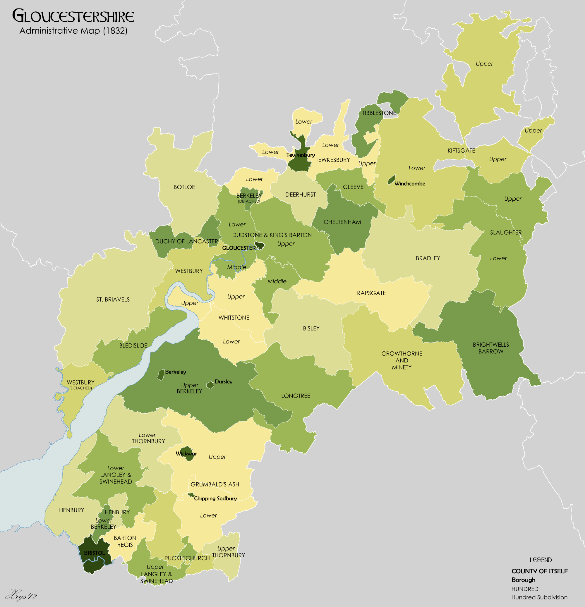
Gloucestershire 1832 Map
Gloucestershire ( abbreviated Glos) is a Counties of England, county in South West England. The county comprises part of the Cotswold Hills, part of the flat fertile valley of the River Severn and the entire Forest of Dean. The county town is the City status in the United Kingdom, city of Gloucester and other principal towns and villages include Cheltenham, Cirencester, Kingswood, South Gloucestershire, Kingswood, Bradley Stoke, Stroud, Thornbury, Gloucestershire, Thornbury, Yate, Tewkesbury, Bishop's Cleeve, Churchdown, Brockworth, Winchcombe, Dursley, Cam, Gloucestershire, Cam, Berkeley, Gloucestershire, Berkeley, Wotton-under-Edge, Tetbury, Moreton-in-Marsh, Fairford, Lechlade, Northleach, Stow-on-the-Wold, Chipping Campden, Bourton-on-the-Water, Stonehouse, Gloucestershire, Stonehouse, Nailsworth, Minchinhampton, Painswick, Winterbourne, Gloucestershire, Winterbourne, Frampton Cotterell, Coleford, Gloucestershire, Coleford, Cinderford, Lydney and Rodborough and Cainscros ... [...More Info...] [...Related Items...] OR: [Wikipedia] [Google] [Baidu] |
Hewelsfield
Hewelsfield is a village in Hewelsfield and Brockweir civil parish, in the Forest of Dean district of Gloucestershire, England. The village is located 6 miles south of Coleford and 5 miles north-east of Chepstow, close to the Wye valley and partly within an Area of Outstanding Natural Beauty. History The area was known in the Anglo-Saxon period as ''Hiwoldestone''. It was included by William the Conqueror in the Royal Forest of Dean, but by the 12th century was established as a village, with a church. Ancient routes running up from the River Severn at Alvington and Woolaston met at Hewelsfield village and continued to the nearby village of St. Briavels. In 1266 the manor of Hewelsfield was granted to Tintern Abbey, which retained it until the Dissolution in 1536. Together with the abbey grange at Brockweir, the manor was then granted to Henry Somerset, 2nd Earl of Worcester. There is evidence of a small castle motte close to the church, and earthworks close to the cast ... [...More Info...] [...Related Items...] OR: [Wikipedia] [Google] [Baidu] |
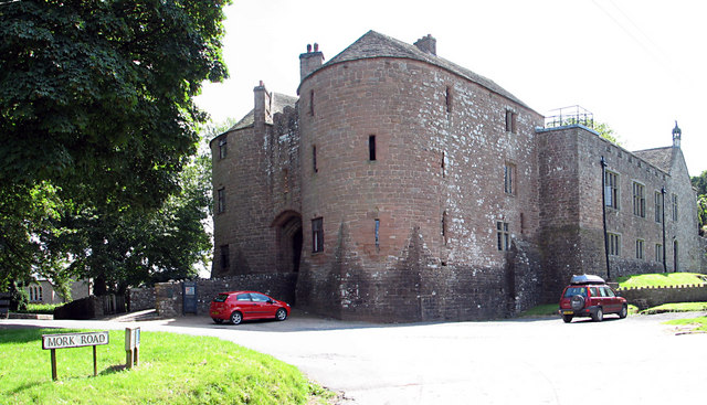
St Briavels Castle
St Briavels Castle is a moated Norman castle at St Briavels in the English county of Gloucestershire. The castle is noted for its huge Edwardian gatehouse that guards the entrance. St Briavels Castle was originally built between 1075 and 1129 as a royal administrative centre for the Forest of Dean. During the 13th century the castle became first a favourite hunting lodge of King John, and then the primary centre in England for the manufacture of quarrels, large numbers of which were required for crossbows in medieval warfare. The castle was transferred many times between royal favourites in the 14th and 15th centuries and slowly declined in appearance and importance. St Briavels Castle became used primarily as a court and as a notorious debtors' prison, conditions being documented by the prison reformer John Howard in 1775. Following local riots and a parliamentary investigation in the 1830s, reforms in the 19th century brought an end to the castle's use as a prison. Extensive ... [...More Info...] [...Related Items...] OR: [Wikipedia] [Google] [Baidu] |
Lea, Herefordshire
Lea is a village and civil parish in the South East of Herefordshire, just south-east of Ross-on-Wye and adjoining Gloucestershire. Amenities include a school, church, village hall, shop, public house, garage and a twice weekly mobile Post Office, all of which lie on the A40 road which passes through the village. The railway engineering company Alan Keef Ltd has its headquarters on the outskirts of the village. Between 1855 and 1964, Lea was served by Mitcheldean Road railway station on the Hereford, Ross and Gloucester Railway The Hereford, Ross and Gloucester Railway (also known as the Gloucester and Dean Forest Railway), was a railway which ran for linking Hereford and Gloucester, England, via Ross-on-Wye. It was opened on 1 June 1855 as a broad gauge line, it .... References External linksLea Parish Council [...More Info...] [...Related Items...] OR: [Wikipedia] [Google] [Baidu] |
Staunton, Near Coleford, Gloucestershire
Staunton is a village and civil parish in the Forest of Dean in west Gloucestershire, England, close to the border with Wales. Location Staunton is 2.5 miles east of Monmouth and 2.5 miles north west of Coleford in the Forest of Dean, on the border of England and Wales. The main road which passes through Staunton is the A4136 road. History The name Staunton comes from the Old English words ''Stane'' (as in Stane Street) and ''Tun'' meaning "stony farmstead or settlement". Stane may also refer to six notable stones within the parish, including a rocky outcrop called the Frog or Toad's Mouth at the west end of the village. The Long Stone, a pillar of rock or possible standing stone, (which may date from before 1700 BC) is visible on the Coleford road. The Broad Stone is the largest of several rocks in the fields of Broadstone Farm. The Buckstone is nearby, as are the Suck Stone and the Near Hearkening Rock. There is little documented history of the parish of Staunton ... [...More Info...] [...Related Items...] OR: [Wikipedia] [Google] [Baidu] |
Ruardean
Ruardean is a village in the Forest of Dean, Gloucestershire, England, to the North West of Cinderford. It is situated on a hillside with views west towards the mountains of South Wales. Little now remains of the village's industrial history, but once it was a centre for iron ore smelting furnaces, forges and coal mines. The Norman castle, now little more than a mound, commanded the shortest route from Gloucester Castle to the Welsh Marches and the Wye Valley. History The village has been, in times past, an important centre of iron and coal mining, though little evidence remains of this aspect of the village's history. The main historical landmark of the village is Ruardyn Castle, near to the parish church. In the past the village was spelt as Ruardyn and was part of Herefordshire. Nowadays the village lies inside Gloucestershire and is part of the Forest of Dean district. Like much of the surrounding area, Ruardean has historically been relatively poor; the 1831 census records 12 ... [...More Info...] [...Related Items...] OR: [Wikipedia] [Google] [Baidu] |
Newland, Gloucestershire
Newland is a village and civil parish in the Forest of Dean in Gloucestershire, England. situated on the east side of the River Wye, south-east of Monmouth. It is notable for its parish church of All Saints, known as the 'Cathedral of the Forest'. It was the centre of a large parish with complex boundaries and scattered settlements. The church The church, dedicated to All Saints, was founded shortly before 1216. It was sited on a low, flat-topped hill, sheltered by higher hills except to the south where the land descends to the River Wye. The church comprises a chancel with side chapels, an aisled nave with south chapel and south porch, and a west tower. The tower was begun in the late 13th century, although the upper stages are of the late 14th or early 15th century. The chancel, the chapel south of it, the arcades and aisles, and the south porch are mainly 14th century features, and the north and east chapels were added in the 15th century. The church was thoroughly restored ... [...More Info...] [...Related Items...] OR: [Wikipedia] [Google] [Baidu] |
Mitcheldean
Mitcheldean is a market town in the Forest of Dean in Gloucestershire, England. History Mitcheldean was a thriving community for many centuries due to the town's proximity to iron ore deposits. During the 19th century, the town grew due to revenues produced by the local brewing industry. Like several of the Forest of Dean villages, Mitcheldean was a close-knit community with individual traditions. One of these was the locally famous (or infamous) Mitcheldean Prize Brass Band. It is vividly remembered and described in a memoir by Arthur Bullock, a resident of nearby Longhope, whose father and brothers were in it. Recounting the band's exploits, he comments, 'I only wish I could have been privileged to hear the Mitcheldean Prize Brass Band play when all of the players were fully sober at the same time'. However, it is indeed sobering to read his further reflection that the band must have been 'killed off by the 1914-18 war'. In the 20th century the town grew further due to the Rank ... [...More Info...] [...Related Items...] OR: [Wikipedia] [Google] [Baidu] |
Flaxley
Flaxley is a small settlement and former civil parish, now in the parish of Blaisdon, in the Forest of Dean, Gloucestershire, England. It is located in between the larger villages of Westbury-on-Severn and Mitcheldean. In 1931 the parish had a population of 87. History The origin of the place-name is from the Old English words ''fleax'' and ''leah'' meaning place where flax is grown; the place-name appears as ''Flaxlea'' in 1163. Flaxley was once a major industrial centre. The Forest of Dean was an important medieval ironworking region, and the earliest forge in Flaxley is recorded in the 12th century. Westbury Brook was the site of five water mills, and at Gun's Mill by Flaxley was one of the main gun foundries of the English Civil War era. A blast furnace was built there in 1629. Today, Flaxley offers a pleasant picturesque wooded scene and is difficult to imagine it any other way, but it has a strong industrial past, notably of iron furnaces, forges and water mills. The earl ... [...More Info...] [...Related Items...] OR: [Wikipedia] [Google] [Baidu] |
Hundred (county Subdivision)
A hundred is an administrative division that is geographically part of a larger region. It was formerly used in England, Wales, some parts of the United States, Denmark, Southern Schleswig, Sweden, Finland, Norway, the Bishopric of Ösel–Wiek, Curonia, the Ukrainian state of the Cossack Hetmanate and in Cumberland County, New South Wales, Cumberland County in the British Colony of New South Wales. It is still used in other places, including in Australia (in South Australia and the Northern Territory). Other terms for the hundred in English and other languages include ''#wapentake, wapentake'', ''herred'' (Danish and Bokmål, Bokmål Norwegian), ''herad'' (Nynorsk, Nynorsk Norwegian), ''hérað'' (Icelandic), ''härad'' or ''hundare'' (Swedish), ''Harde'' (German), ''hiird'' (North Frisian language, North Frisian), ''satakunta'' or ''kihlakunta'' (Finnish), ''kihelkond'' (Estonian), ''kiligunda'' (Livonian), ''cantref'' (Welsh) and ''sotnia'' (Slavic). In Ireland, a similar subdi ... [...More Info...] [...Related Items...] OR: [Wikipedia] [Google] [Baidu] |
Littledean
Littledean is a village in the Forest of Dean, west Gloucestershire, England. The village has a long history and formerly had the status of a town. Littledean Hall was originally a Saxon hall, although it has been rebuilt and the current house dates back to 1612. The remains of a Roman temple are situated in the grounds. Neither the hall or Roman remains are open to the public. Collectively, the villages and the surrounding wood (Forest of Dean) were mentioned in the Domesday Book as ''Dene'', and appear as ''Dena'' in 1130. Governance The village falls in the 'Littledean and Ruspidge' Wards and electoral divisions of the United Kingdom, electoral ward. This ward has Littledean in the north plus Ruspidge and Soudley civil parish in the south. The total ward population taken at the 2011 census was 3,768. Notable buildings *Littledean Hall, a country house. *The former prison in Littledean, which is now a crime museum. *Æthelberht II of East Anglia, St Ethelbert's Church, whose c ... [...More Info...] [...Related Items...] OR: [Wikipedia] [Google] [Baidu] |
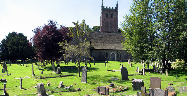
St Briavels
St Briavels (pronounced ''Brevels'', once known as 'Ledenia Parva' (Little Lydney)), is a medium-sized village and civil parish in the Royal Forest of Dean in west Gloucestershire, England; close to the England-Wales border, and south of Coleford, Gloucestershire, Coleford. It stands almost above sea level on the edge of a limestone plateau above the valley of the River Wye, above an ancient meander of the river. To the west, Cinder Hill drops off sharply into the valley. It is sheltered behind the crumbling walls of the 12th century St Briavels Castle. History Little is known about the origin of St Briavels. The name is thought to be from a much-travelled early Christianity, Christian missionary, Brioc, whose name also appears in places as far afield as Cornwall and Brittany. Later King Offa of Mercia built Offa's Dyke from the mouth of the River Wye near Chepstow to Prestatyn and local remains can still be seen in the nearby Hudnalls Wood. The Normans thought it an ideal si ... [...More Info...] [...Related Items...] OR: [Wikipedia] [Google] [Baidu] |


.jpg)
