|
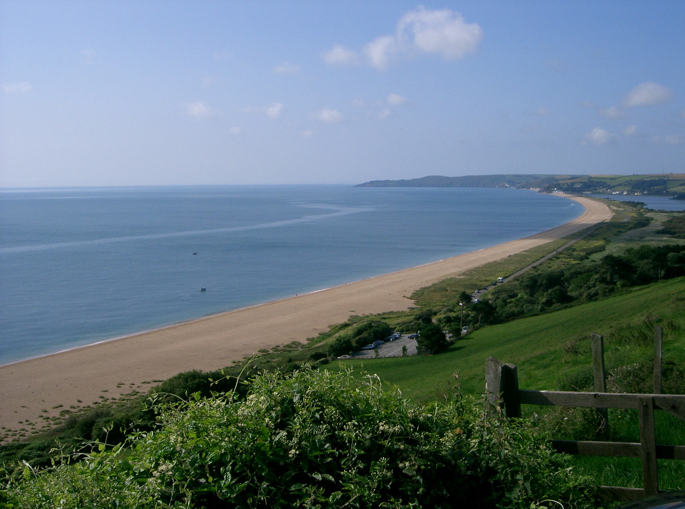
Slapton Sands 1 , Northamptonshire, a village
{{geodis ...
Slapton may refer to the following places in the United Kingdom: * Slapton, Buckinghamshire, a village and civil parish * Slapton, Devon, a village and civil parish * Slapton, Northamptonshire, a village See also * Slapton Castle, an Iron Age hill fort near Slapton, Devon * Slapton Ley, a lake on the south coast of Devon * Slipton Slipton is a village in the North Northamptonshire civil parish of Lowick. Slipton has a small but exquisite church, St John The Baptist, a short walk from Main Street by footpath on the east side of the village. The church is what makes Slipto ... [...More Info...] [...Related Items...] OR: [Wikipedia] [Google] [Baidu] |
Slapton, Buckinghamshire
Slapton is a village and also a civil parish within Aylesbury Vale district in Buckinghamshire, England. It is located between the Grand Union Canal and the boundary with Bedfordshire, about south of Leighton Buzzard and west of Edlesborough. Hamlets Towards the edge of the parish near Horton in Ivinghoe is the hamlet of Horton Wharf. The village of Grove is also within the boundary of Slapton parish. History The village name is Anglo Saxon in origin, and means "farm by a slippery place". It is a common place name. This village was recorded in the Domesday Book of 1086 as ''Slapetone''. The manor of Slapton once belonged to a convent in Barking, Essex, though it was seized by the Crown in the Dissolution of the Monasteries in 1547. The manor was for some time after that the property of the Earl of Bridgwater. The village hall was built and given to the village by the Griffin family of Bury Farm in memory of Elizabeth Griffin in the 1950s. Until recently, the Griffin fa ... [...More Info...] [...Related Items...] OR: [Wikipedia] [Google] [Baidu] |
Slapton, Devon
Slapton is a village and civil parish in the South Hams district of Devon, England. It is located near the A379 road between Kingsbridge and Dartmouth, and lies within the South Devon Area of Outstanding Natural Beauty (AONB). The nearby beach is Slapton Sands; despite its name, it is not a sandy beach but a shingle one. In 1901 the population of the civil parish was 527, decreasing to 473 in 2001, and decreasing further to 434 at the 2011 census. The parish is surrounded clockwise from the north by the parishes of Blackawton, Strete, Stokenham and East Allington. History Slapton was recorded in the Domesday Book of 1086 as ''Sladone''. The Collegiate Chantry of St Mary was founded in 1372 or 1373 by Sir Guy de Brian. The Tower Inn and West tower remain and the tower has been designated by English Heritage as a grade I listed building. The Church of St James dates from the late 13th or early 14th century, and is also grade I listed. The nearby beach is a coastal bar ... [...More Info...] [...Related Items...] OR: [Wikipedia] [Google] [Baidu] |
Slapton, Northamptonshire
Slapton is a small village in Northamptonshire, England, about from Towcester and the same from Silverstone. It is close to the A43 road which links the M40 motorway junction 10 with the M1 junction 15A at Northampton. Central London is about 60 miles south of M40 junction 10. At the 2011 Census the population remained less than 100 and was included in the civil parish of Whilton. The village's name means 'farm/settlement which is slippery' or 'farm/settlement which is muddy'. Governance Slapton is represented on Woodend Parish Council. Prior to local government changes in 2021 it formed part of the Blakesley & Cote ward of South Northants District Council. The village was in the area of Northamptonshire County Council. The current Parliamentary Constituency is Daventry. However, for the 2010 General Election there are boundary changes. The Boundary Commission originally retained the parish in the revised Daventry constituency, but after consultation with local r ... [...More Info...] [...Related Items...] OR: [Wikipedia] [Google] [Baidu] |
Slapton Castle
Slapton Castle is an Iron Age hill fort situated close to Slapton in Devon, England. The fort is on a promontory on the eastern side of a hilltop at approximately above sea level, overlooking Slapton Ley Slapton Ley is a lake on the south coast of Devon, England, separated from Start Bay by a shingle beach, known as Slapton Sands. Slapton Ley is the largest natural freshwater lake in south-west England being long and has two sections; the Low .... References External links * Hill forts in Devon Stokenham {{UK-archaeology-stub ... [...More Info...] [...Related Items...] OR: [Wikipedia] [Google] [Baidu] |
Slapton Ley
Slapton Ley is a lake on the south coast of Devon, England, separated from Start Bay by a shingle beach, known as Slapton Sands. Slapton Ley is the largest natural freshwater lake in south-west England being long and has two sections; the Lower Ley and the Higher Ley. The ley is fed by streams and a small river, The Gara, that flows into the Higher Ley. The site is a National Nature Reserve, a Site of Special Scientific Interest and a Geological Conservation Review site. The nature reserve covers over . The A379 between the Ley and the sea runs along the shingle ridge and was rebuilt after damage by coastal erosion in the early 2000s. Ecology and wildlife The Slapton Ley nature reserve is owned by the Whitley Wildlife Conservation Trust and managed by the Field Studies Council. Slapton Ley’s beaches are affected by erosion but the beaches are formed from sediment; this makes them special because they are non-replaceable: once the sediment is moved it is gone. The beach ca ... [...More Info...] [...Related Items...] OR: [Wikipedia] [Google] [Baidu] |
