|
Shizukuishi
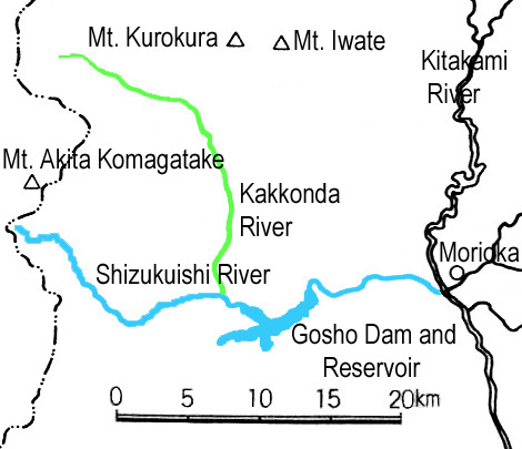
is a town located in Iwate Prefecture, Japan. , the town had an estimated population of 16,263 in 6354 households, and a population density of 27 persons per km². The total area of the town is . Geography Shizukuishi is located in the Ōu Mountains of west-central Iwate Prefecture, bordering Akita Prefecture to the west. Mount Iwate (2038 m), an active volcano, lies just to the north of Shizukuishi and dominates the landscape. The Ōu Mountains form the boundary to the west as well with Akita Komagatake, another active volcano, just across the border in Akita Prefecture. The downtown area is located where the Shizukuishi and Kakkonda Rivers meet. Gosho Lake was created in 1981 with the completion of Gosho Dam. Neighboring municipalities Iwate Prefecture *Morioka *Yahaba * Shiwa *Hanamaki * Nishiwaga *Takizawa * Hachimantai Akita Prefecture * Semboku Climate Shizukuishi has a cold humid continental climate (Köppen ''Dfa'') characterized by mild summers and cold winters with ... [...More Info...] [...Related Items...] OR: [Wikipedia] [Google] [Baidu] |
Shizukuishi River
The is a river in Iwate Prefecture, in the Tōhoku region of northern Honshū in Japan. The river is long and has a watershed of . The Shizukuishi River rises in the Ōu Mountains just south of Mount Akita-Komagatake in the town of Shizukuishi and empties into the Kitakami River in the city of Morioka. The Gosho Dam is situated on the Shizukuishi River in western Morioka. This dam was completed in 1981. The entire length of the river is home to many renowned hot springs A hot spring, hydrothermal spring, or geothermal spring is a spring produced by the emergence of geothermally heated groundwater onto the surface of the Earth. The groundwater is heated either by shallow bodies of magma (molten rock) or by c .... External links Rivers of Iwate Prefecture Shizukuishi, Iwate Takizawa, Iwate Morioka, Iwate Rivers of Japan {{Iwate-geo-stub ... [...More Info...] [...Related Items...] OR: [Wikipedia] [Google] [Baidu] |
Iwate District, Iwate
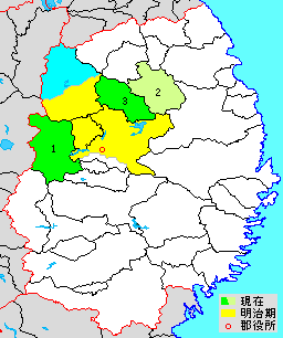
is a rural district located in Iwate Prefecture, Japan. As of June 1, 2019, the district has an estimated population of 34,416 with a density of 24.5 per km2 and an area of 1404.24 km2. The entire city of Takizawa, the southern half of the city of Hachimantai and most of the city of Morioka were formerly part of Iwate District. Towns and villages The district consists of three towns: * Iwate * Kuzumaki * Shizukuishi History Under Mutsu Province Iwate District was the northernmost of the six districts of northern Mutsu Province (六奥郡)created in the early Heian period after the conquest of the Kitakami River Valley from the Emishi tribes by the Japanese army led by General Sakanoue no Tamuramaro. The districts were named by Emperor Heizei, and the name of “Iwate” was originally written with the ''kanji'' 磐手, and appears in this form in the ''Yamato Monogatari'', compiled in the year 951. By the middle Heian period, the ''kanji'' had changed to its present ... [...More Info...] [...Related Items...] OR: [Wikipedia] [Google] [Baidu] |
Takizawa, Iwate
is a city located in Iwate Prefecture, Japan. , the city had an estimated population of 55,325 in 23,270 households, and a population density of 300 persons per km2. The total area of the city is . Geography Takizawa is located in central Iwate Prefecture, bordered to the north and west by the Iwate Mountains, and the Kitakami River to the east and the Shizukuishi River to the south. Neighboring municipalities Iwate Prefecture *Morioka * Hachimantai * Shizukuishi Climate Takizawa has a cold humid continental climate (Köppen ''Dfa'') characterized by mild summers and cold winters with heavy snowfall. The average annual temperature in Takizawa is 9.5 °C. The average annual rainfall is 1386 mm with September as the wettest month and February as the driest month. The temperatures are highest on average in August, at around 23.3 °C, and lowest in January, at around -3.3 °C. Demographics Per Japanese census data, the population of Takizawa grew rapidly ... [...More Info...] [...Related Items...] OR: [Wikipedia] [Google] [Baidu] |
Iwate Prefecture
is a prefecture of Japan located in the Tōhoku region of Honshu. It is the second-largest Japanese prefecture at , with a population of 1,210,534 (as of October 1, 2020). Iwate Prefecture borders Aomori Prefecture to the north, Akita Prefecture to the west, and Miyagi Prefecture to the south. Morioka is the capital and largest city of Iwate Prefecture; other major cities include Ichinoseki, Ōshū, and Hanamaki. Located on Japan's Pacific Ocean coast, Iwate Prefecture features the easternmost point of Honshu at Cape Todo, and shares the highest peaks of the Ōu Mountains—the longest mountain range in Japan—at the border with Akita Prefecture. Iwate Prefecture is home to famous attractions such as Morioka Castle, the Buddhist temples of Hiraizumi including Chūson-ji and Mōtsū-ji, the Fujiwara no Sato movie lot and theme park in Ōshū, and the Tenshochi park in Kitakami known for its huge, ancient cherry trees. Iwate has the lowest population density of any prefe ... [...More Info...] [...Related Items...] OR: [Wikipedia] [Google] [Baidu] |
Yahaba, Iwate
is a town in Iwate Prefecture, Japan. , the town had an estimated population of 27,227, and a population density of 400 persons per km² in 10,131 households. The total area of the town is . Geography Yahaba is located in central Iwate Prefecture, bordered by Morioka city to the north, Shiwa town to the south and Shizukuishi to the west. Neighboring municipalities Iwate Prefecture *Morioka * Shiwa * Shizukuishi Climate Yahaba has a humid oceanic climate (Köppen climate classification ''Cfa'') characterized by mild summers and cold winters. The average annual temperature in Yahaba is 10.1 °C. The average annual rainfall is 1341 mm with September as the wettest month and February as the driest month. The temperatures are highest on average in August, at around 23.8 °C, and lowest in January, at around -2.6 °C. Demographics Per Japanese census data, the population of Yahaba has seen a long and steady increase over the past century. History The area of ... [...More Info...] [...Related Items...] OR: [Wikipedia] [Google] [Baidu] |
Morioka, Iwate
is the capital city of Iwate Prefecture located in the Tōhoku region of northern Japan. On 1 February 2021, the city had an estimated population of 290,700 in 132,719 households, and a population density of . The total area of the city is . Geography Morioka is located in the in central Iwate Prefecture, at the confluence of three rivers, the Kitakami, the Shizukuishi and the Nakatsu. The Kitakami River is the second largest river on the Pacific side of Japan (after the Tone River) and the longest in the Tōhoku region. It runs through the city from north to south and has a number of dams within the city boundaries, including the Shijūshida Dam and Gandō Dam. An active volcano, Mount Iwate, dominates the view to the northwest of the city. Mount Himekami is to the north and Mount Hayachine can sometimes be seen to the southeast. Surrounding municipalities Iwate Prefecture *Hanamaki * Hachimantai *Takizawa is a city located in Iwate Prefecture, Japan. , the c ... [...More Info...] [...Related Items...] OR: [Wikipedia] [Google] [Baidu] |
Hachimantai, Iwate
is a city located in Iwate Prefecture, Japan. , the city had an estimated population of 25,076, and a population density of 29 persons per km2 in 10,531 households. The total area of the city is . Geography Hachimantai is located in the Ōu Mountains of far northwest Iwate Prefecture, bordered by Aomori Prefecture to the north and Akita Prefecture to the west. The headwaters of the Yoneshiro River are in Hachimanai. Part of Mount Hachimantai and Mount Iwate are within its borders. Parts of the city are within the borders of the Towada-Hachimantai National Park. Mount Iwate, the highest mountain in Iwate Prefecture, is on the border of Hachimantai with Shizukuishi and Takizawa. Neighboring municipalities Aomori Prefecture * Takko Akita Prefecture * Kazuno * Semboku Iwate Prefecture *Morioka *Ninohe *Takizawa * Ichinohe * Iwate * Shizukuishi Climate Hachimantai has a humid continental climate (Köppen climate classification ''Dfa''), the same as much of Hokkaido to the nort ... [...More Info...] [...Related Items...] OR: [Wikipedia] [Google] [Baidu] |
Mount Iwate
is a stratovolcano complex in the Ōu Mountains of western Iwate Prefecture, in the Tōhoku region of northern Honshū, Japan. With an elevation of , it is the highest in Iwate Prefecture. It is included as one of the 100 famous mountains in Japan, a book composed in 1964 by mountaineer and author Kyūya Fukada.Hyakumeizan, Hiking Japan! . Japan Gazetteer. Accessed June 27, 2008. The mountain is on the borders of the municipalities of Hachimantai, , and Shizukuishi, west of the prefectural ... [...More Info...] [...Related Items...] OR: [Wikipedia] [Google] [Baidu] |
Nishiwaga, Iwate
is a town in Iwate Prefecture, Japan. , the town had an estimated population of 5,468 in 2279 households, and a population density of 9 persons per km². The total area of the town is . The total area was . Geography Nishiwaga is located in the far southwestern corner of Iwate Prefecture, in the river valley of the Waga River, surrounded by the 1000-meter peaks of the Ōu Mountains on three sides. The area is noted for its extremely heavy snowfall in winter. The Yuda Dam is located in Nishiwaga and the Yuda Onsenkyō Prefectural Natural Park is located completely within its borders. Neighboring municipalities Iwate Prefecture *Hanamaki * Kitakami * Ōshū * Shizukuishi Akita Prefecture * Semboku * Daisen * Yokote * Misato *Higashinaruse Climate Nishiwaga has a humid continental climate (Köppen ''Dfa'') characterized by mild summers and cold winters with heavy snowfall. The average annual temperature in Nishiwaga is 8.9 °C. The average annual rainfall is 1561 mm ... [...More Info...] [...Related Items...] OR: [Wikipedia] [Google] [Baidu] |
Hanamaki, Iwate
is a city in Iwate Prefecture, Japan. , the city had an estimated population of 94,691, and a population density of 100 persons per km², in 37,773 households. The total area of the city is . Hanamaki is famous as the birthplace of Kenji Miyazawa and for its hot spring resorts. Geography Hanamaki is located in central Iwate Prefecture, in the Kitakami River valley at the conflux of three rivers with the Kitakami River; the Sarugaishi-gawa from the east and the Se-gawa and Toyosawa-gawa from the west. In the west the city rises to the foothills of the Ōu Mountains with the highest peak being Mt. Matsukura at . To the east the city rises to the highest peak in the Kitakami Range, Mount Hayachine at . The largest reservoir is Lake Tase on the Sarugaishi River. Lake Hayachine on the Hienuki River is quite spectacular with steep mountains rising above it. Lake Toyosawa is in the western part of the city on the Toyosawa River. Parts of the city are within the borders of the Haya ... [...More Info...] [...Related Items...] OR: [Wikipedia] [Google] [Baidu] |
Shiwa, Iwate
is a town in Iwate Prefecture, Japan. , the town had an estimated population of 33,090, in 12338 households, and a population density of 134 persons per km². The total area of the town is . Geography Shiwa is located in central Iwate Prefecture, in the Kitakami River basin, south of the prefectural capital of Morioka. The Sannōkai Dam is located in Shiwa. Neighboring municipalities Iwate Prefecture *Morioka *Hanamaki * Shizukuishi * Yahaba Climate Shiwa has a humid oceanic climate (Köppen climate classification ''Cfa'') characterized by mild summers and cold winters. The average annual temperature in Shiwa is 10.3 °C. The average annual rainfall is 1326 mm with September as the wettest month and February as the driest month. The temperatures are highest on average in August, at around 24.0 °C, and lowest in January, at around -2.3 °C. Demographics Per Japanese census data, the population of Shiwa has remained relatively steady over the past 70 year ... [...More Info...] [...Related Items...] OR: [Wikipedia] [Google] [Baidu] |


