|
Shawmut Peninsula
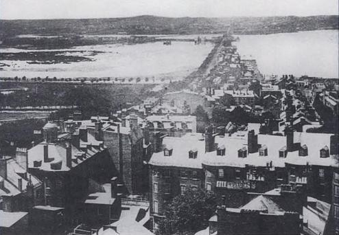
Shawmut Peninsula is the promontory of land on which Boston, Massachusetts was built. The peninsula, originally a mere in area,Miller, Bradford A., "Digging up Boston: The Big Dig Builds on Centuries of Geological Engineering", GeoTimes, October 2002. more than doubled in size due to land reclamation efforts that were a feature of the history of Boston throughout the 19th century. Geology and original topography Like much of the Massachusetts landscape, the peninsula was shaped by glacial erosion and moraine deposits left by retreating glaciers at the end of the last ice age. When Europeans arrived, Shawmut was thickly forested. The pre-settlement topography of the peninsula was marked by three hills: Copps Hill, in what is now the North End; Fort Hill, in today's Financial District; and the Trimountain, today's Beacon Hill district. Of the three hills, the Trimountain was by far the largest, a steep-sided mass with three summits. Its name was eventually shortened to Tremont. ... [...More Info...] [...Related Items...] OR: [Wikipedia] [Google] [Baidu] |
Shawmut
Shawmut, according to 19th-century scholarship, is a term derived from the Algonquian word ''Mashauwomuk'' referring to the region of present-day Boston, Massachusetts.Forsford, Eben Norton, ''The Indian names of Boston, and their meaning''University Press, 1886. It appears in a number of present-day placenames. Origin of the word It appears in print very early in the history of New England; records from 1630 note that William Blaxton was "dwelling on the other side of Charles River, alone, at a place by the Indians called Shawmutt". The meaning of ''Shawmut'' is uncertain. Most explanations refer to either the salt water surrounding the peninsula, from which come explanations like "canoe landing place" or "place to ferry across", or to the springs of fresh water found within, a major inducement for the settlement of the Massachusetts Bay Colony at that site. Examples of the placename This word appears in several place-names, not all of which can be traced with certainty to t ... [...More Info...] [...Related Items...] OR: [Wikipedia] [Google] [Baidu] |
Wetland
A wetland is a distinct ecosystem that is flooded or saturated by water, either permanently (for years or decades) or seasonally (for weeks or months). Flooding results in oxygen-free (anoxic) processes prevailing, especially in the soils. The primary factor that distinguishes wetlands from terrestrial land forms or Body of water, water bodies is the characteristic vegetation of aquatic plants, adapted to the unique anoxic hydric soils. Wetlands are considered among the most biologically diverse of all ecosystems, serving as home to a wide range of plant and animal species. Methods for assessing wetland functions, wetland ecological health, and general wetland condition have been developed for many regions of the world. These methods have contributed to wetland conservation partly by raising public awareness of the functions some wetlands provide. Wetlands occur naturally on every continent. The water in wetlands is either freshwater, brackish or seawater, saltwater. The main w ... [...More Info...] [...Related Items...] OR: [Wikipedia] [Google] [Baidu] |
Salt Marsh
A salt marsh or saltmarsh, also known as a coastal salt marsh or a tidal marsh, is a coastal ecosystem in the upper coastal intertidal zone between land and open saltwater or brackish water that is regularly flooded by the tides. It is dominated by dense stands of salt-tolerant plants such as herbs, grasses, or low shrubs. These plants are terrestrial in origin and are essential to the stability of the salt marsh in trapping and binding sediments. Salt marshes play a large role in the aquatic food web and the delivery of nutrients to coastal waters. They also support terrestrial animals and provide coastal protection. Salt marshes have historically been endangered by poorly implemented coastal management practices, with land reclaimed for human uses or polluted by upstream agriculture or other industrial coastal uses. Additionally, sea level rise caused by climate change is endangering other marshes, through erosion and submersion of otherwise tidal marshes. However, recent ackn ... [...More Info...] [...Related Items...] OR: [Wikipedia] [Google] [Baidu] |
Urban Wild
An urban wild is a remnant of a natural ecosystem found in the midst of an otherwise highly developed urban area. Utility Urban wilds, particularly those of several acres or more, are often intact ecological systems that can provide essential ecosystem functions such as the filtering of urban run-off, the storing and slowing the flow of stormwater, amelioration of the warming effect of urban development, and generally benefiting local air quality. Typically, urban wilds are home to native vegetation and animal life as well as some introduced species. Urban wilds are vital to species of migratory birds that have nested in a given area since prior to its urbanization. Preservation Without formal protection, urban wilds are vulnerable to development. However, achieving formal protection of a large urban wild can be difficult. Land tenure of a single ecological area can be complex, with multiple public and private entities owning adjacent properties. Key strategies used in the ... [...More Info...] [...Related Items...] OR: [Wikipedia] [Google] [Baidu] |
Freshwater
Fresh water or freshwater is any naturally occurring liquid or frozen water containing low concentrations of dissolved salts and other total dissolved solids. Although the term specifically excludes seawater and brackish water, it does include non- salty mineral-rich waters such as chalybeate springs. Fresh water may encompass frozen and meltwater in ice sheets, ice caps, glaciers, snowfields and icebergs, natural precipitations such as rainfall, snowfall, hail/ sleet and graupel, and surface runoffs that form inland bodies of water such as wetlands, ponds, lakes, rivers, streams, as well as groundwater contained in aquifers, subterranean rivers and lakes. Fresh water is the water resource that is of the most and immediate use to humans. Water is critical to the survival of all living organisms. Many organisms can thrive on salt water, but the great majority of higher plants and most insects, amphibians, reptiles, mammals and birds need fresh water to survive. Fresh wa ... [...More Info...] [...Related Items...] OR: [Wikipedia] [Google] [Baidu] |
Back Bay Fens
The Back Bay Fens, often called The Fens, is a parkland and urban wild in Boston, Massachusetts, in the United States. It was established in 1879. Designed by Frederick Law Olmsted to serve as a link in the Emerald Necklace park system, the Fens gives its name to the Fenway-Kenmore neighborhood. History The Fens is a large picturesque park that forms part of Boston's Emerald Necklace. It is essentially an ancient spot of saltwater marshland that has been surrounded by dry land, disconnected from the tides of the Atlantic Ocean, and landscaped into a park with fresh water within. The park is also known as the Fens or the Fenway. The latter term can also refer to either the surrounding neighborhood or the parkway on its southern border. When Boston was settled in the early 17th century the Shawmut Peninsula on which it was built was connected to Roxbury by a spit of sandy ground called " The Neck." The adjacent area of marshland to the west was a tidal flat of the Charles R ... [...More Info...] [...Related Items...] OR: [Wikipedia] [Google] [Baidu] |
Back Bay
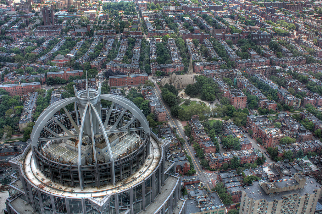
Back Bay is an officially recognized neighborhood of Boston, Massachusetts, built on reclaimed land in the Charles River basin. Construction began in 1859, as the demand for luxury housing exceeded the availability in the city at the time, and the area was fully built by around 1900. It is most famous for its rows of Victorian brownstone homes—considered one of the best preserved examples of 19th-century urban design in the United States—as well as numerous architecturally significant individual buildings, and cultural institutions such as the Boston Public Library, and Boston Architectural College. Initially conceived as a residential-only area, commercial buildings were permitted from around 1890, and Back Bay now features many office buildings, including the John Hancock Tower, Boston's tallest skyscraper. It is also considered a fashionable shopping destination (especially Newbury and Boylston Streets, and the adjacent Prudential Center and Copley Place malls) and home ... [...More Info...] [...Related Items...] OR: [Wikipedia] [Google] [Baidu] |
South End, Boston
The South End is a neighborhood of Boston, Massachusetts. It is bordered by Back Bay, Chinatown, and Roxbury. It is distinguished from other neighborhoods by its Victorian style houses and the many parks in and around the area. The South End is the largest intact Victorian row house district in the country, as it is made up of over 300 acres. Eleven residential parks are contained within the South End. In 1973, the South End was listed in the National Register of Historic Places. Much of the South End was originally marshlands in Boston's South Bay. After being filled in, construction of the neighborhood began in 1849. It is home to many diverse groups, including immigrants, young families, and professionals, and it is very popular with the gay and lesbian community of Boston. Since the 1880s the South End has been characterized by its diversity, with substantial Irish, Jewish, African-American, Puerto Rican (in the San Juan Street area), Chinese, and Greek populations. In 2 ... [...More Info...] [...Related Items...] OR: [Wikipedia] [Google] [Baidu] |
Beacon Hill, Boston, Massachusetts
Beacon Hill is a historic Neighborhoods in Boston, neighborhood in Boston, Massachusetts, and the hill upon which the Massachusetts State House resides. The term "Beacon Hill" is used locally as a metonym to refer to the state government or the legislature itself, much like Washington, D.C., Washington, D.C.'s "Capitol Hill" does at the federal level. Federal architecture, Federal-style rowhouses, narrow gas lighting, gaslit streets and brick sidewalks adorn the neighborhood, which is generally regarded as one of the more desirable and expensive in Boston. According to the 2010 U.S. Census, the population of Boston's Beacon Hill neighborhood is 9,023. Etymology Like many similarly named areas, the neighborhood is named for the location of a former beacon atop the highest point in central Boston. The beacon was used to warn the residents of an invasion. Geography Beacon Hill is bounded by Storrow Drive, and Cambridge, Bowdoin Street, Bowdoin, Park Street, Boston, Park and ... [...More Info...] [...Related Items...] OR: [Wikipedia] [Google] [Baidu] |
Charlestown, Massachusetts
Charlestown is the oldest neighborhood in Boston, Massachusetts, in the United States. Originally called Mishawum by the Massachusett tribe, it is located on a peninsula north of the Charles River, across from downtown Boston, and also adjoins the Mystic River and Boston Harbor waterways. Charlestown was laid out in 1629 by engineer Thomas Graves, one of its earliest settlers, during the reign of Charles I of England. It was originally a separate town and the first capital of the Massachusetts Bay Colony. Charlestown became a city in 1848 and was annexed by Boston on January 5, 1874. With that, it also switched from Middlesex County, to which it had belonged since 1643, to Suffolk County. It has had a substantial Irish-American population since the migration of Irish people during the Great Irish Famine of the 1840s. Since the late 1980s, the neighborhood has changed dramatically because of its proximity to downtown and its colonial architecture. A mix of yuppie and upper-mid ... [...More Info...] [...Related Items...] OR: [Wikipedia] [Google] [Baidu] |


