|
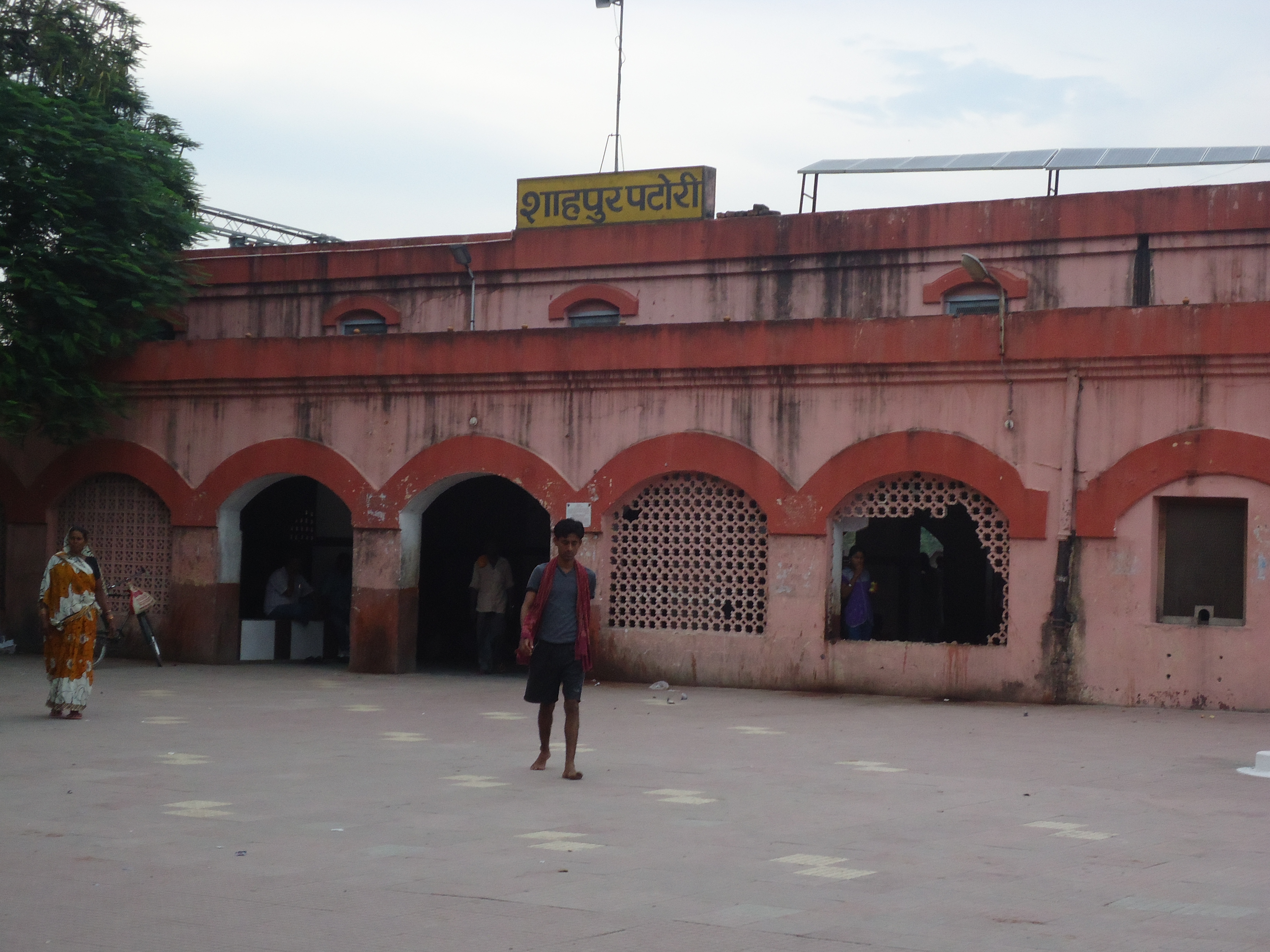
Shahpur Patori Railway Station
Shahpur Patori station, station code SPP, is a railway station in the Sonpur railway division of East Central Railway The East Central Railway (abbreviated ECR) is one of the 19 Zones and divisions of Indian Railways, railway zones in India. It is headquartered at Hajipur and comprises Sonpur railway division, Sonpur, Samastipur railway division, Samastipur, .... Shahpur Patori station is located in Shahpur Patori block in Samastipur district in the Indian state of Bihar. This railway station was established in 1901. Earlier, the location of this station was somewhere between Shahpur Undi and Bahadurpur Patori villages. It was relocated to its present place in 1938. An interesting story is there about naming of the station. The dispute arose between the villagers of the two adjoining villages, each wanted to name the station after the name of their villages. Finally, it was settled that the 'Shahpur' word would be taken from the village name Shahpur Undi and 'Patori' ... [...More Info...] [...Related Items...] OR: [Wikipedia] [Google] [Baidu] |
Shahpur Patori Station
Shahpur, Shapur, Shahpoor, or Shahapur ( fa, شاه پور) may refer to: People * Shapur (name), Persian given name and a list of people with the name Places India Bihar * Shahpur, Bihar, a city in Bhojpur district ** Shahpur, Bihar Assembly constituency * Shahpur, Aurangabad, a village in Aurangabad district * Shahpur, Araria, a village in Araria district * Shahpur, Saharsa, a village in Saharsa district * Shahpur Patori railway station in Shahpur Patori block Delhi * Shahpur Jat, an urban village in South Delhi Gujarat * Shahpur, Gujarat, a city and notified area in Ahmedabad district * Shahpur, Kheralu, a village in Kheralu taluka, Mehsana district * Shahpur Mosque, a mosque in Ahmedabad * Shapur Sorath, a town in Junagadh district Haryana * Shahpur, Indri, a village in Indri Tehsil, Karnal district, Haryana * Shahpur, Nissing, a village in Nissing, Karnal district, Haryana Himachal Pradesh * Shahpur, Kangra, a village in Kangra district, Hima ... [...More Info...] [...Related Items...] OR: [Wikipedia] [Google] [Baidu] |
Indian Railways
Indian Railways (IR) is a statutory body under the ownership of Ministry of Railways, Government of India that operates India's national railway system. It manages the fourth largest national railway system in the world by size, with a total route length of . or 83% of all the broad-gauge routes are electrified with 25 kV 50 Hz AC electric traction . In 2020, Indian Railways carried 808.6 crore (8.086 billion) passengers and in 2022, Railways transported 1418.1 million tonnes of freight. It runs 13,169 passenger trains daily, on both long-distance and suburban routes, covering 7,325 stations across India. Mail or Express trains, the most common types of trains, run at an average speed of . Suburban EMUs run at an average speed of . Ordinary passenger trains (incl. mixed) run at an average speed of . The maximum speed of passenger trains varies, with the Vande Bharat Express running at a peak speed of . In the freight segment, IR runs 8,479 trains daily. The a ... [...More Info...] [...Related Items...] OR: [Wikipedia] [Google] [Baidu] |
Shahpur Patori
Shahpur, Shapur, Shahpoor, or Shahapur ( fa, شاه پور) may refer to: People * Shapur (name), Persian given name and a list of people with the name Places India Bihar * Shahpur, Bihar, a city in Bhojpur district ** Shahpur, Bihar Assembly constituency * Shahpur, Aurangabad, a village in Aurangabad district * Shahpur, Araria, a village in Araria district * Shahpur, Saharsa, a village in Saharsa district * Shahpur Patori railway station in Shahpur Patori block Delhi * Shahpur Jat, an urban village in South Delhi Gujarat * Shahpur, Gujarat, a city and notified area in Ahmedabad district * Shahpur, Kheralu, a village in Kheralu taluka, Mehsana district * Shahpur Mosque, a mosque in Ahmedabad * Shapur Sorath, a town in Junagadh district Haryana * Shahpur, Indri, a village in Indri Tehsil, Karnal district, Haryana * Shahpur, Nissing, a village in Nissing, Karnal district, Haryana Himachal Pradesh * Shahpur, Kangra, a village in Kangra district, Hima ... [...More Info...] [...Related Items...] OR: [Wikipedia] [Google] [Baidu] |
Samastipur District
Samastipur is one of the thirty-eight districts of Bihar in India. The district headquarters are located at Samastipur. The district occupies an area of 2904 km² and has a population of 4,261,566. History Samastipur became a district in 1972 when it was split from Darbhanga district. Samastipur consists of four sub-divisions :- # Rosera # Samastipur # Dalsinghsarai, Dalshinghsarai # Shahpur Patory Geography Samastipur district occupies an area of , comparatively equivalent to Indonesia's Muna Island. Samastipur is bounded on the north by the Bagmati River which forms part of the border with Darbhanga district. On the west it is bordered by Vaishali district, Vaishali and Muzaffarpur district, Muzaffarpur districts, on the south by the Ganga, which forms the border with Patna district, while on its southeast are Begusarai district, Begusarai and Khagaria district, Khagaria districts. The district headquarters is located at Samastipur. The district is largely agricultu ... [...More Info...] [...Related Items...] OR: [Wikipedia] [Google] [Baidu] |
Bihar
Bihar (; ) is a state in eastern India. It is the 2nd largest state by population in 2019, 12th largest by area of , and 14th largest by GDP in 2021. Bihar borders Uttar Pradesh to its west, Nepal to the north, the northern part of West Bengal to the east, and with Jharkhand to the south. The Bihar plain is split by the river Ganges, which flows from west to east. On 15 November 2000, southern Bihar was ceded to form the new state of Jharkhand. Only 20% of the population of Bihar lives in urban areas as of 2021. Additionally, almost 58% of Biharis are below the age of 25, giving Bihar the highest proportion of young people of any Indian state. The official languages are Hindi and Urdu, although other languages are common, including Maithili, Magahi, Bhojpuri and other Languages of Bihar. In Ancient and Classical India, the area that is now Bihar was considered the centre of political and cultural power and as a haven of learning. From Magadha arose India's first empire, ... [...More Info...] [...Related Items...] OR: [Wikipedia] [Google] [Baidu] |
Barauni–Gorakhpur, Raxaul And Jainagar Lines
The Barauni–Gorakhpur, Raxaul and Jainagar lines are a set of three lines connecting Barauni in the Indian state of Bihar with Gorakhpur in Uttar Pradesh. The lines run in an east–west direction between the Ganges and India-Nepal border, covering northern Bihar west of the Kosi river and eastern Uttar Pradesh. The southernmost of the lines connects via Hajipur Junction, Sonpur Junction and Chhapra. The central line connects via Muzaffarpur, Motihari and Sugauli. The northern line connects via Darbhanga, Sitamarhi and Raxaul. The lines have interconnections between them and the northern line has extensions to places near the India–Nepal border. History Railway lines in the area were pioneered by Tirhut Railway and the Bengal and North Western Railway lines in the 19th century. In his book ''The Indian Empire, Its People, History and Products'' (first published in 1886) W.W.Hunter, says "The Tirhut State Railway with its various branches intersects Northern Behar and ... [...More Info...] [...Related Items...] OR: [Wikipedia] [Google] [Baidu] |
East Central Railway Zone
The East Central Railway (abbreviated ECR) is one of the 19 railway zones in India. It is headquartered at Hajipur and comprises Sonpur, Samastipur, Danapur, Pt. Deen Dayal Upadhyaya, and Dhanbad divisions. History First set up on 8 September 1996 with headquarters at Hajipur, Bihar, East Central Railway became operational on 1 October 2002 by carving out areas from Eastern and North Eastern Railway zones currently consists of the divisions viz. Dhanbad, Danapur, Mughalsarai of Eastern Railway and Sonpur and Samastipur of North Eastern Railway. The last 13 years of its existence has been full of challenges and every obstacle was dealt in a dedicated manner despite constraints of work force and infrastructure. ECR, has a vast network of 5402.693 track kilometers and 3707.988 route kilometers encompassing the states of Bihar, Jharkhand, Uttar Pradesh and Madhya Pradesh. Out of the route, have been electrified. ECR has been lifeline for the people in its expanse and i ... [...More Info...] [...Related Items...] OR: [Wikipedia] [Google] [Baidu] |
East Indian Railway
The East Indian Railway Company, operating as the East Indian Railway (reporting mark EIR), introduced railways to East India and North India, while the Companies such as the Great Indian Peninsula Railway, South Indian Railway, Bombay, Baroda and Central India Railway and the North-Western Railway operated in other parts of India. The company was established 1 June 1845 in London by a deed of settlement with a capital of £4,000,000, largely raised in London. 1845–1849 The first board of directors formed in 1845 comprised thirteen members and Rowland Macdonald Stephenson became the first managing director of the company. Rowland Macdonald Stephenson (later Sir Rowland, but familiarly known as Macdonald StephensonDiaries of George Turnbull (Chief Engineer, East Indian Railway Company) held at the Centre of South Asian Studies at Cambridge University, England) and three assistants travelled from England in 1845 and ''"with diligence and discretion"'' surveyed, statistic ... [...More Info...] [...Related Items...] OR: [Wikipedia] [Google] [Baidu] |
Sonpur Railway Division
Sonpur railway division is one of the five railway divisions under East Central Railway zone of Indian Railways. History Sonpur division was established on 21 Oct. 1978 in North Eastern Railway zone. The ECR zone came into existence on 8 September 1996. Garhara yard and Dinkar Gram Simaria station were merged into this division on 1 January 2005. The Divisional Railway Manager (DRM) is Nilmani and the Additional Divisional Railway Manager (ADRM) is Pankaj Kumar Sinha. Geography It follows the north side of the Ganges and the west side of the Gandak River. The division routes over 495.361 km, all on BG. This division traverses through 8 districts of Bihar: Saran, Vaishali, Muzaffarpur, Samastipur, Begusarai, Khagaria, Bhagalpur and Katihar. Its headquarter is located at Hajipur, Bihar in the state of Bihar of India. Danapur railway division, Mughalsarai railway division, Dhanbad railway division, and Samastipur railway division Samastipur railway division i ... [...More Info...] [...Related Items...] OR: [Wikipedia] [Google] [Baidu] |
Community Development Block In India
In India, a Community development block (CD block) or simply Block is a sub-division of Tehsil, administratively earmarked for planning and development. The area is administered by a Block Development Officer (BDO), supported by several technical specialists and village-level workers. A community development block covers several gram panchayats, the local administrative units at the village level. Nomenclature Only in the state of West Bengal are CD blocks considered the third level administrative units (equal to tehsils in North India. Elsewhere, tehsils are also called Talukas in the Western Indian states of Goa, Gujarat, Maharashtra and South Indian states of Karnataka, Kerala, and Tamil Nadu. In Arunachal Pradesh and Nagaland, the term Circles are used, while Sub-divisions are present in the Eastern Indian states of Bihar, Jharkhand, Assam, and most of Northeast India (Manipur, Meghalaya, Mizoram, Sikkim and Tripura). In Andhra Pradesh and Telangana, a newer form of admini ... [...More Info...] [...Related Items...] OR: [Wikipedia] [Google] [Baidu] |


_1_by_N._A._Naseer.jpg)

