|
Selocta Chinnabby
Selocta Chinnabby (also Shelocta, ''Se-loc-ta'', Chinnabee, or Apuckshunubee) (c. 1765—October 15, 1834 or February 10, 1835) was a Muskogee Creek and Natchez chief from present-day Talladega County, Alabama. He allied himself with the Andrew Jackson in fighting the Red Sticks in the Creek War, which was part of the larger War of 1812. Family Chinnabby was possibly born in 1765 near Choccolocco Creek and was the son of a Natchez chief, Moss Micco Chinnabby, and a Creek mother. After the Natchez revolt, a portion of the Natchez moved to central Alabama and settled in an abandoned village near the Coosa River on Tallaseehatchee Creek. This new village was known as Natchee or Natchez Town. Chinnabby's father accompanied Alexander McGillivray to New York City to participate in the signing of the 1790 Treaty of New York. Chinnabby had a brother whose name was Salarta/Salarto Fixico (General Coffee). Adult life During the Creek War, Chinnabby sided with the United States in figh ... [...More Info...] [...Related Items...] OR: [Wikipedia] [Google] [Baidu] |
Battles Of Emuckfaw And Enotachopo Creek
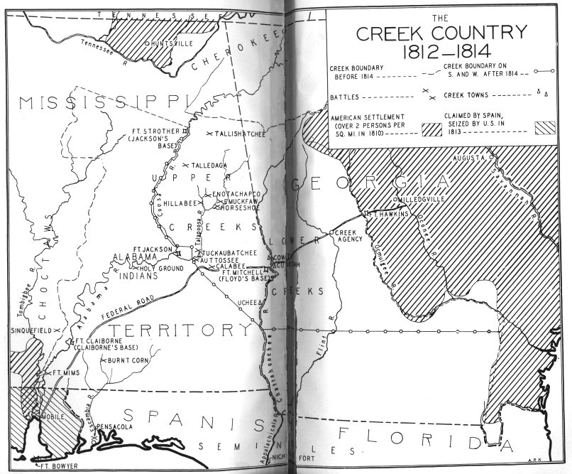
The battles of Emuckfaw and Enotachopo Creek (or Enotachopco Creek) were part of Andrew Jackson's campaign in the Creek War. They took place in January 1814, approximately northeast of Horseshoe Bend. Background After Talladega, Jackson was plagued by supply shortages and discipline problems arising from his men's short-term enlistments. General John Coffee, who had returned to Tennessee for remounts, wrote Jackson that the cavalry had deserted. By the end of 1813, Jackson was down to a single regiment whose enlistments were due to expire in mid-January. Although Governor Willie Blount had ordered a new levy of 2,500 troops, Jackson would not be up to full strength until the end of February. When a draft of 900 raw recruits arrived unexpectedly on January 14, Jackson was down to a cadre of 103 and Coffee, who had been "abandoned by his men." Jackson's men consisted of 175 militia and 30 artillery before the battle and were aided by Lower Creek and Cherokee natives, who had ar ... [...More Info...] [...Related Items...] OR: [Wikipedia] [Google] [Baidu] |
Taski Etoka
Taski Etoka (also Mingatuska, Tuskeatoka) (died 1794) was a Native American (Chickasaw) leader of the mid-1780s. He was signator (along with Piominko and Lotapaia), of the Treaty of Hopewell in January 1786."The Last of the Chickasaw Kings" /ref> Taski Etoka was succeeded by Selocta Chinnabby
Selocta Chinnabby (also Shelocta, ''Se-loc-ta'', Chinnabee, or Apuckshunubee) (c. 1765—October 15, 1834 or February 10, 1835) was a Muskogee Creek and Natchez chief from present-day Talladega County, ...
[...More Info...] [...Related Items...] OR: [Wikipedia] [Google] [Baidu] |
Chickasaw
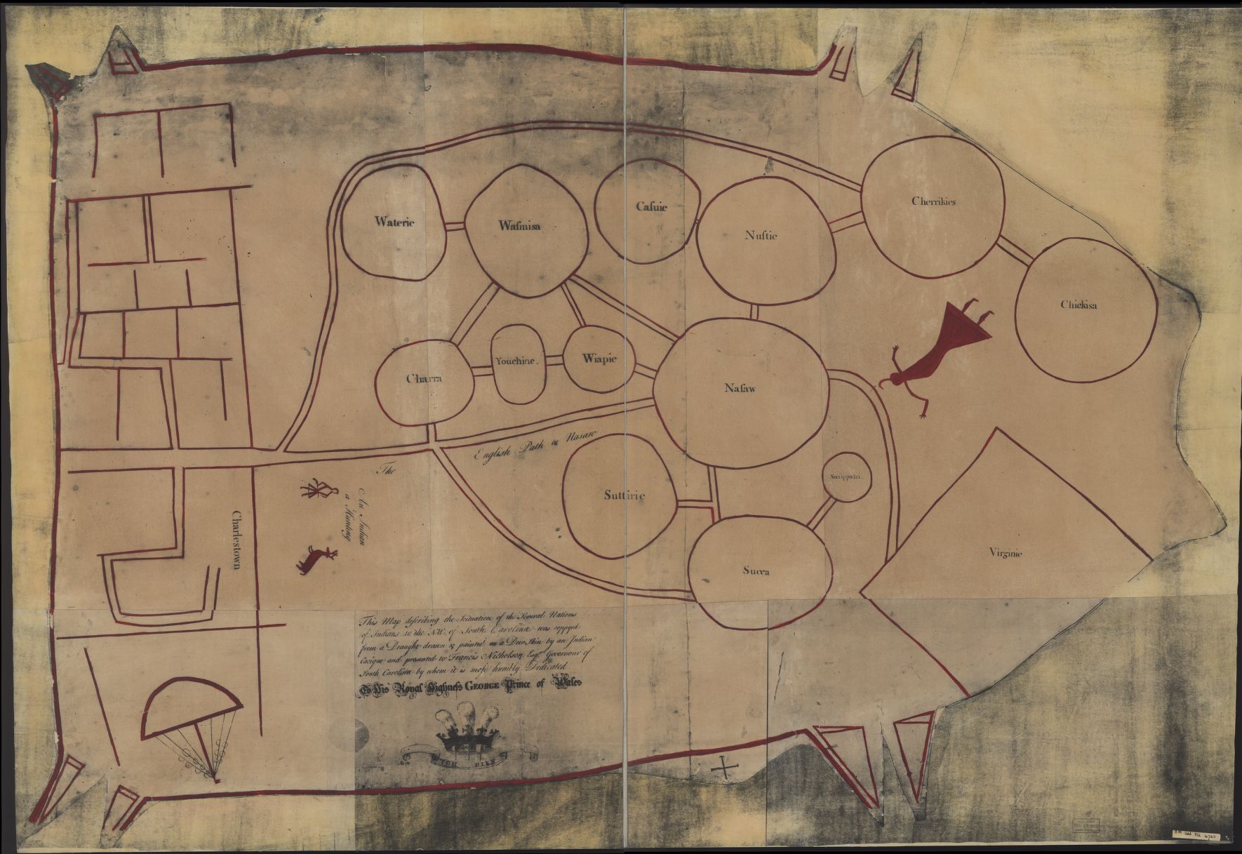
The Chickasaw ( ) are an indigenous people of the Southeastern Woodlands. Their traditional territory was in the Southeastern United States of Mississippi, Alabama, and Tennessee as well in southwestern Kentucky. Their language is classified as a member of the Muskogean language family. In the present day, they are organized as the Federally recognized tribe, federally recognized Chickasaw Nation. Chickasaw people have a migration story in which they moved from a land west of the Mississippi River, where they settled mostly in present-day northeast Mississippi, northwest Alabama, and into Lawrence County, Tennessee. They had interaction with French, English, and Spanish colonists during the Colonial history of the United States, colonial period. The United States considered the Chickasaw one of the Five Civilized Tribes of the Southeast, as they adopted numerous practices of European Americans. Resisting European-American settlers encroaching on their territory, they were force ... [...More Info...] [...Related Items...] OR: [Wikipedia] [Google] [Baidu] |
Cherokee
The Cherokee (; chr, ᎠᏂᏴᏫᏯᎢ, translit=Aniyvwiyaʔi or Anigiduwagi, or chr, ᏣᎳᎩ, links=no, translit=Tsalagi) are one of the indigenous peoples of the Southeastern Woodlands of the United States. Prior to the 18th century, they were concentrated in their homelands, in towns along river valleys of what is now southwestern North Carolina, southeastern Tennessee, edges of western South Carolina, northern Georgia, and northeastern Alabama. The Cherokee language is part of the Iroquoian language group. In the 19th century, James Mooney, an early American ethnographer, recorded one oral tradition that told of the tribe having migrated south in ancient times from the Great Lakes region, where other Iroquoian peoples have been based. However, anthropologist Thomas R. Whyte, writing in 2007, dated the split among the peoples as occurring earlier. He believes that the origin of the proto-Iroquoian language was likely the Appalachian region, and the split betw ... [...More Info...] [...Related Items...] OR: [Wikipedia] [Google] [Baidu] |
Seminole Wars
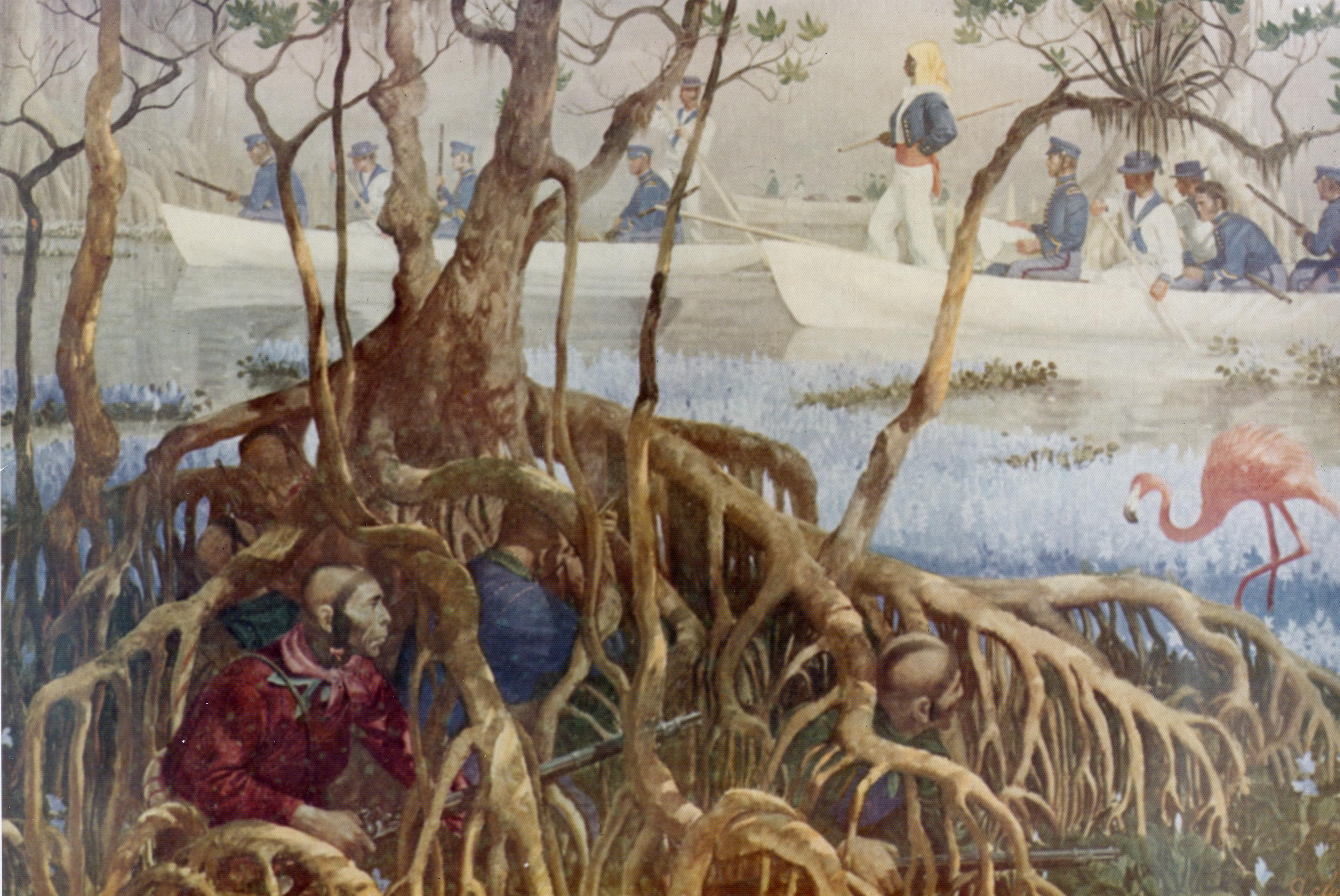
The Seminole Wars (also known as the Florida Wars) were three related military conflicts in Geography of Florida, Florida between the United States and the Seminole, citizens of a Native Americans in the United States, Native American nation which formed in the region during the early 1700s. Hostilities commenced about 1816 and continued through 1858, with two periods of uneasy truce between active conflict. The Seminole Wars were the longest and most expensive, in both human and financial cost to the United States, of the American Indian Wars. Overview First Seminole War The First Seminole War (1817-1818)-"Beginning in the 1730's, the Spaniards had given refuge to runaway slaves from the Carolinas, but as late as 1774 Fugitive slaves in the United States, Negroes [did] not appear to have been living among the Florida Indians." After that latter date more runaway slaves began arriving from American plantations, especially congregating around "Negro Fort on the Apalachicola Riv ... [...More Info...] [...Related Items...] OR: [Wikipedia] [Google] [Baidu] |
Trail Of Tears
The Trail of Tears was an ethnic cleansing and forced displacement of approximately 60,000 people of the "Five Civilized Tribes" between 1830 and 1850 by the United States government. As part of the Indian removal, members of the Cherokee, Muscogee (Creek), Seminole, Chickasaw, and Choctaw nations were forcibly removed from their ancestral homelands in the Southeastern United States to newly designated Indian Territory west of the Mississippi River after the passage of the Indian Removal Act in 1830. The Cherokee removal in 1838 (the last forced removal east of the Mississippi) was brought on by the discovery of gold near Dahlonega, Georgia, in 1828, resulting in the Georgia Gold Rush. The relocated peoples suffered from exposure, disease, and starvation while en route to their newly designated Indian reserve. Thousands died from disease before reaching their destinations or shortly after. Some historians have said that the event constituted a genocide, although this label ... [...More Info...] [...Related Items...] OR: [Wikipedia] [Google] [Baidu] |
Great Britain
Great Britain is an island in the North Atlantic Ocean off the northwest coast of continental Europe. With an area of , it is the largest of the British Isles, the largest European island and the ninth-largest island in the world. It is dominated by a maritime climate with narrow temperature differences between seasons. The 60% smaller island of Ireland is to the west—these islands, along with over 1,000 smaller surrounding islands and named substantial rocks, form the British Isles archipelago. Connected to mainland Europe until 9,000 years ago by a landbridge now known as Doggerland, Great Britain has been inhabited by modern humans for around 30,000 years. In 2011, it had a population of about , making it the world's third-most-populous island after Java in Indonesia and Honshu in Japan. The term "Great Britain" is often used to refer to England, Scotland and Wales, including their component adjoining islands. Great Britain and Northern Ireland now constitute the ... [...More Info...] [...Related Items...] OR: [Wikipedia] [Google] [Baidu] |
Alabama River
The Alabama River, in the U.S. state of Alabama, is formed by the Tallapoosa and Coosa rivers, which unite about north of Montgomery, near the town of Wetumpka. The river flows west to Selma, then southwest until, about from Mobile, it unites with the Tombigbee, forming the Mobile and Tensaw rivers, which discharge into Mobile Bay. Description The run of the Alabama is highly meandering. Its width varies from , and its depth from . Its length as measured by the United States Geological Survey is ,U.S. Geological Survey. National Hydrography Dataset high-resolution flowline dataThe National Map, accessed April 27, 2011 and by steamboat measurement, . The river crosses the richest agricultural and timber districts of the state. Railways connect it with the mineral regions of north-central Alabama. After the Coosa and Tallapoosa rivers, the principal tributary of the Alabama is the Cahaba River, which is about long and joins the Alabama River about below Selma. The Ala ... [...More Info...] [...Related Items...] OR: [Wikipedia] [Google] [Baidu] |
Treaty Of Fort Jackson
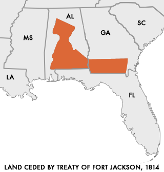
The Treaty of Fort Jackson (also known as the Treaty with the Creeks, 1814) was signed on August 9, 1814 at Fort Jackson near Wetumpka, Alabama following the defeat of the Red Stick (Upper Creek) resistance by United States allied forces at the Battle of Horseshoe Bend. It occurred on the banks of the Tallapoosa River near the present city of Alexander City, Alabama. The U.S. force, led by General Andrew Jackson, consisted mainly of the West Tennessee Militia and 39th United States Infantry, allied with several groups of Cherokee and Lower Creek friendly to the American side. The Upper Creek were led by Chief Menawa, who fled with hundreds of survivors into Florida, where they allied with the Seminole. The surrender ended the Creek War, which the United States was fighting simultaneously with the War of 1812."Fort Jackson Tr ... [...More Info...] [...Related Items...] OR: [Wikipedia] [Google] [Baidu] |
Hillabee
Hillabee was an important Muscogee (Creek) town in east central Alabama before the Indian Removals of the 1830s. Hillabee was the center of a cluster of towns and villages, known as the Hillabee complex or, simply, Hillabee. The people living in the Hillabee complex area are sometimes called the Hillabees. That name does not refer to a separate tribe or clan but merely those Muscogees who lived in the Hillabee complex area. The word "Hillabee" comes from the Muscogee language word /hílapi/, meaning quick or swift, perhaps referring to the streams in the area. Location Hillabee and its satellite villages were located along Little Hillabee Creek and Enitachopco Creek where they join to form Big Hillabee Creek. Villages within the complex, along these streams, included Echoseis Ligau, Enitachopko, Lanudshi Apala, and Oktasassi. Nearby towns and villages associated with Hillabee include Oakfuskee, Little Oakfuskee, and Atchinalgi. Today the area is in southern Clay County and north ... [...More Info...] [...Related Items...] OR: [Wikipedia] [Google] [Baidu] |
Fort Strother
Fort Strother was a stockade fort at Ten Islands in the Mississippi Territory, in what is today St. Clair County, Alabama. It was located on a bluff of the Coosa River, near the modern Neely Henry Dam in Ragland, Alabama. The fort was built by General Andrew Jackson and several thousand militiamen in November 1813, during the Creek War and was named for Captain John Strother, Jackson's chief cartographer. History Creek War On November 1, 1813, General Jackson reached the area of Ten Islands and began construction of Fort Strother. The fort was rectangular in shape and had blockhouses at each corner. It also included a supply building, eight hospital huts, and twenty-five tents. While constructing the fort, Jackson received news of a large number of Red Sticks that were in the village of Tallasseehatchee. He instructed General John Coffee to attack the village, resulting in the Battle of Tallushatchee. After the Battle of Tallushatchee, Red Stick warriors under the command of Will ... [...More Info...] [...Related Items...] OR: [Wikipedia] [Google] [Baidu] |


