|
Seal Islands (California)
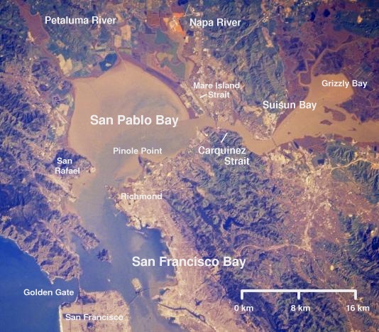
Seal Islands are a pair of islands in Suisun Bay at the mouth of the Sacramento-San Joaquin River Delta in Contra Costa County, California, 10 km east of Benicia Benicia ( , ) is a waterside city in Solano County, California, located in the North Bay region of the San Francisco Bay Area. It served as the capital of California for nearly thirteen months from 1853 to 1854. The population was 26,997 at the ..., and 500 metres off-shore from the former Concord Naval Weapons Station and Port Chicago Naval Magazine. See also * List of islands of California References Islands of Contra Costa County, California Islands of the San Francisco Bay Area Islands of the Sacramento–San Joaquin River Delta Islands of Northern California Islands of Suisun Bay {{ContraCostaCountyCA-geo-stub ... [...More Info...] [...Related Items...] OR: [Wikipedia] [Google] [Baidu] |
Northern California
Northern California (colloquially known as NorCal) is a geographic and cultural region that generally comprises the northern portion of the U.S. state of California. Spanning the state's northernmost 48 counties, its main population centers include the San Francisco Bay Area (anchored by the cities of San Jose, San Francisco, and Oakland), the Greater Sacramento area (anchored by the state capital Sacramento), the Redding, California, area south of the Cascade Range, and the Metropolitan Fresno area (anchored by the city of Fresno). Northern California also contains redwood forests, along with most of the Sierra Nevada, including Yosemite Valley and part of Lake Tahoe, Mount Shasta (the second-highest peak in the Cascade Range after Mount Rainier in Washington), and most of the Central Valley, one of the world's most productive agricultural regions. The 48-county definition is not used for the Northern California Megaregion, one of the 11 megaregions of the United States. Th ... [...More Info...] [...Related Items...] OR: [Wikipedia] [Google] [Baidu] |
Suisun Bay
Suisun Bay ( ; Wintun for "where the west wind blows") is a shallow tidal estuary (a northeastern extension of the San Francisco Bay) in Northern California. It lies at the confluence of the Sacramento River and San Joaquin River, forming the entrance to the Sacramento–San Joaquin River Delta, an inverted river delta. To the west, Suisun Bay is drained by the Carquinez Strait, which connects to San Pablo Bay, a northern extension of San Francisco Bay. Suisun Marsh, the tidal marsh land to the north, is the largest marsh in California. Grizzly Bay forms a northern extension of Suisun Bay. Suisun Bay is directly north of Contra Costa County. The bay was named in 1811, after the Suisunes, a Patwin tribe of Wintun Indians. The Central Pacific Railroad built a train ferry that operated between Benicia and Port Costa, California, from 1879 to 1930. The ferry boats ''Solano'' and ''Contra Costa'' were removed from service when the nearby Martinez railroad bridge was completed in ... [...More Info...] [...Related Items...] OR: [Wikipedia] [Google] [Baidu] |
United States
The United States of America (U.S.A. or USA), commonly known as the United States (U.S. or US) or America, is a country primarily located in North America. It consists of 50 states, a federal district, five major unincorporated territories, nine Minor Outlying Islands, and 326 Indian reservations. The United States is also in free association with three Pacific Island sovereign states: the Federated States of Micronesia, the Marshall Islands, and the Republic of Palau. It is the world's third-largest country by both land and total area. It shares land borders with Canada to its north and with Mexico to its south and has maritime borders with the Bahamas, Cuba, Russia, and other nations. With a population of over 333 million, it is the most populous country in the Americas and the third most populous in the world. The national capital of the United States is Washington, D.C. and its most populous city and principal financial center is New York City. Paleo-Americ ... [...More Info...] [...Related Items...] OR: [Wikipedia] [Google] [Baidu] |
Contra Costa County, California
) of the San Francisco Bay , subdivision_type = Country , subdivision_name = United States , subdivision_type1 = State , subdivision_name1 = California , subdivision_type2 = Region , subdivision_name2 = San Francisco Bay Area , seat_type = County seat , seat = Martinez , parts_type = Largest city , parts = Concord (population and land area)Richmond (total area) , unit_pref = US , area_total_sq_mi = 804 , area_land_sq_mi = 715.94 , area_water_sq_mi = 81 , elevation_max_footnotes = , elevation_max_ft = 3852 , population_as_of = 2020 , population_footnotes = , population_total = 1,165,927 , population_density_sq_mi = 1629 , established_title ... [...More Info...] [...Related Items...] OR: [Wikipedia] [Google] [Baidu] |
Benicia, California
Benicia ( , ) is a waterside city in Solano County, California, located in the North Bay region of the San Francisco Bay Area. It served as the capital of California for nearly thirteen months from 1853 to 1854. The population was 26,997 at the 2010 United States Census. The city is located along the north bank of the Carquinez Strait. Benicia is just east of Vallejo and across the strait from Martinez. Steve Young, elected in November 2020, is the mayor. History The City of Benicia was founded on May 19, 1847, by Dr. Robert Semple, Thomas O. Larkin, and Comandante General Mariano Guadalupe Vallejo, on land sold to them by General Vallejo in December 1846. It was named for the General's wife, Francisca Benicia Carillo de Vallejo, a member of the Carrillo family of California, a prominent Californio dynasty. The General intended that the city be named "Francisca" after his wife, but this name was dropped when the former city of "Yerba Buena" changed its name to "San Fran ... [...More Info...] [...Related Items...] OR: [Wikipedia] [Google] [Baidu] |
Concord Naval Weapons Station
Concord Naval Weapons Station was a military base established in 1942 north of the city of Concord, California at the shore of the Sacramento River where it widens into Suisun Bay. The station functioned as a World War II armament storage depot, supplying ships at Port Chicago. During World War II it also had a Naval Outlying Field at the southern edge of the base. It ceased being an operating airfield after World War II. During the Korean War, the Vietnam War and the Gulf War, Concord NWS processed and shipped thousands of tons of materiel out across the Pacific Ocean. The station consisted of two areas: the Inland Area (), which is within the Concord city limits, and the Tidal Area ().About the City of Concord Community Reuse Project , official city web site'. Retrieved 2007-08-13 Because ... [...More Info...] [...Related Items...] OR: [Wikipedia] [Google] [Baidu] |
Port Chicago Naval Magazine
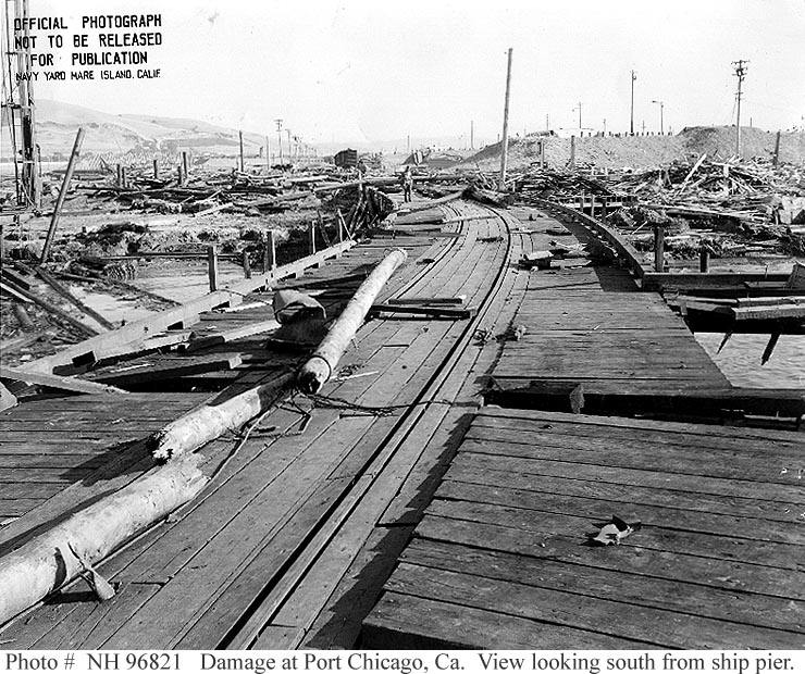
The Port Chicago Naval Magazine National Memorial is a memorial dedicated in 1994 recognizing the dead of the Port Chicago disaster, and the critical role played by Port Chicago, California during World War II, in serving as the main facility for the Asiatic-Pacific Theater, Pacific Theater of Operations. The List of national memorials of the United States, national memorial is located at the Concord Naval Weapons Station near Concord, California, in the United States. The 1944 Port Chicago disaster occurred at the naval Magazine (artillery), magazine and resulted in the largest domestic loss of life during World War II. 320 sailors and civilians were instantly killed on July 17, 1944, when the ships they were loading with ammunition and bombs exploded. The majority of the deaths were African American sailors working for the racial segregation, racially segregated military. The explosion and its aftermath led to the largest Naval mutiny in US history, and it and the subsequent ... [...More Info...] [...Related Items...] OR: [Wikipedia] [Google] [Baidu] |
List Of Islands Of California
This list of islands of California is organized into sections, generally arranged from north to south. The islands within each section are listed in alphabetical order. The Geographic Names Information System (GNIS) lists 527 named islands in the state. Humboldt County Offshore Humboldt Bay All three islands in Humboldt Bay are located in the narrow midsection of the bay. This portion of the bay is located within the City of Eureka, California entirely within Humboldt County. Northern California San Francisco Bay Area Other islands of the San Francisco Bay Area: Farallon Islands The Farallon Islands are a group of rugged small islands over offshore from the mainland of the City and County of San Francisco, which they are also formally within. They consist of over twenty small islets divided into north, south and middle sections, as well as a major bank, Fanny Shoal. The surrounding waters were once used as a disposal site for radioactive waste. Suisun Bay a ... [...More Info...] [...Related Items...] OR: [Wikipedia] [Google] [Baidu] |
Islands Of Contra Costa County, California
An island (or isle) is an isolated piece of habitat that is surrounded by a dramatically different habitat, such as water. Very small islands such as emergent land features on atolls can be called islets, skerries, cays or keys. An island in a river or a lake island may be called an eyot or ait, and a small island off the coast may be called a holm. Sedimentary islands in the Ganges delta are called chars. A grouping of geographically or geologically related islands, such as the Philippines, is referred to as an archipelago. There are two main types of islands in the sea: continental and oceanic. There are also artificial islands, which are man-made. Etymology The word ''island'' derives from Middle English ''iland'', from Old English ''igland'' (from ''ig'' or ''ieg'', similarly meaning 'island' when used independently, and -land carrying its contemporary meaning; cf. Dutch ''eiland'' ("island"), German ''Eiland'' ("small island")). However, the spelling of the word ... [...More Info...] [...Related Items...] OR: [Wikipedia] [Google] [Baidu] |
Islands Of The San Francisco Bay Area
An island (or isle) is an isolated piece of habitat that is surrounded by a dramatically different habitat, such as water. Very small islands such as emergent land features on atolls can be called islets, skerries, cays or keys. An island in a river or a lake island may be called an eyot or ait, and a small island off the coast may be called a holm. Sedimentary islands in the Ganges delta are called chars. A grouping of geographically or geologically related islands, such as the Philippines, is referred to as an archipelago. There are two main types of islands in the sea: continental and oceanic. There are also artificial islands, which are man-made. Etymology The word ''island'' derives from Middle English ''iland'', from Old English ''igland'' (from ''ig'' or ''ieg'', similarly meaning 'island' when used independently, and -land carrying its contemporary meaning; cf. Dutch ''eiland'' ("island"), German ''Eiland'' ("small island")). However, the spelling of the word ... [...More Info...] [...Related Items...] OR: [Wikipedia] [Google] [Baidu] |
Islands Of The Sacramento–San Joaquin River Delta
An island (or isle) is an isolated piece of habitat that is surrounded by a dramatically different habitat, such as water. Very small islands such as emergent land features on atolls can be called islets, skerries, cays or keys. An island in a river or a lake island may be called an eyot or ait, and a small island off the coast may be called a holm. Sedimentary islands in the Ganges delta are called chars. A grouping of geographically or geologically related islands, such as the Philippines, is referred to as an archipelago. There are two main types of islands in the sea: continental and oceanic. There are also artificial islands, which are man-made. Etymology The word ''island'' derives from Middle English ''iland'', from Old English ''igland'' (from ''ig'' or ''ieg'', similarly meaning 'island' when used independently, and -land carrying its contemporary meaning; cf. Dutch ''eiland'' ("island"), German ''Eiland'' ("small island")). However, the spelling of the word ... [...More Info...] [...Related Items...] OR: [Wikipedia] [Google] [Baidu] |
.png)


