|
Schafberg (Schwäbische Alb)
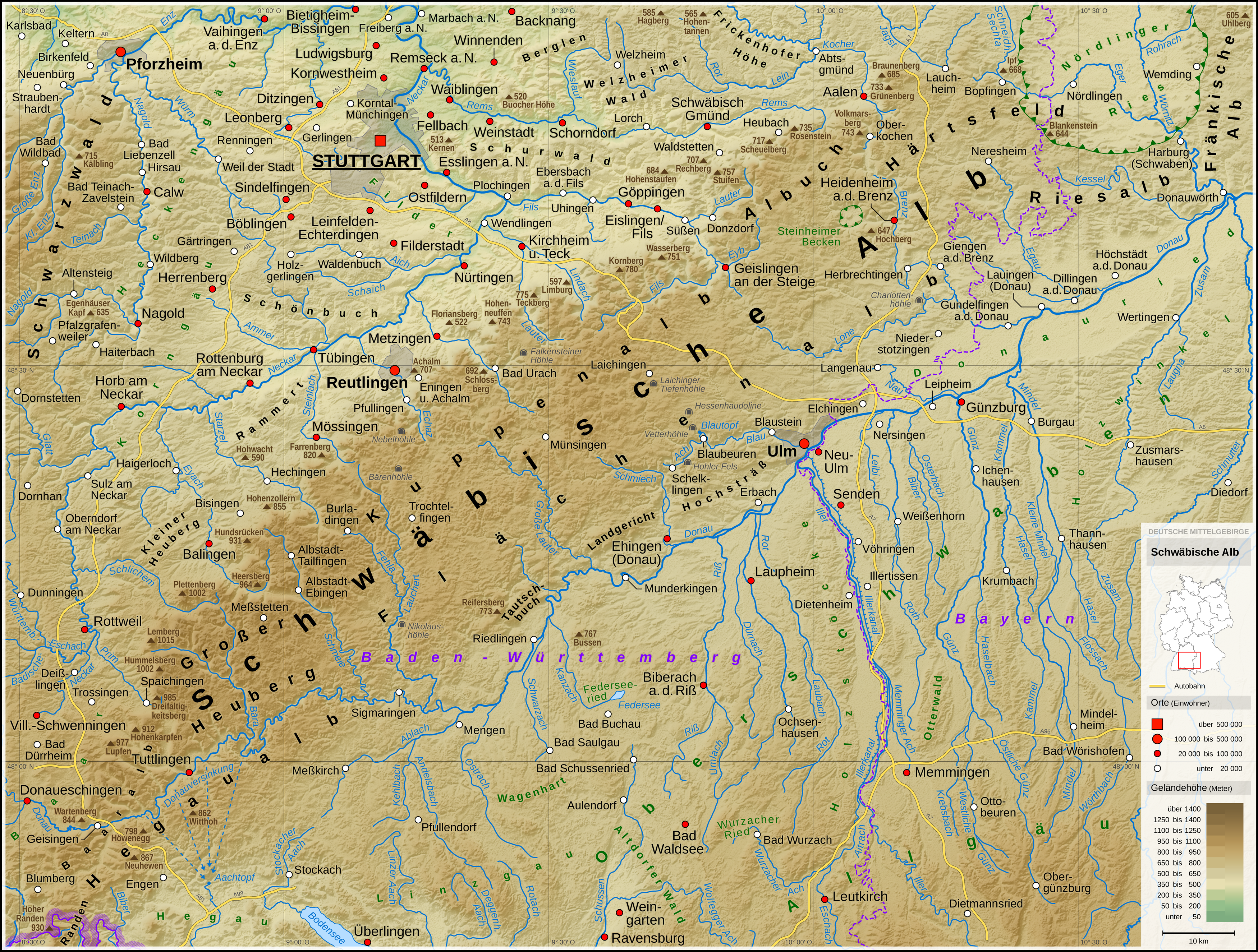
The Schafberg is a mountain, , on the western edge of the Swabian Jura near Balingen in the German state of Baden-Württemberg. It is part of the Balingen Mountains (''Balinger Bergen'') and is surrounded by the towns and villages of Roßwangen, Weilstetten (both in the borough of Balingen), Tieringen (borough of Meßstetten) and Hausen am Tann. Its neighbouring mountains are the Plettenberg () and the Lochenstein (). From the viewing points of ''Hoher Fels'' () and ''Gespaltener Fels'' () there are very good views of the surrounding area. Walks link the Balingen Mountains and the North Swabian Jura Way (''Schwäbische-Alb-Nordrand-Weg'') runs over the Schafberg. The Schafberg lies within the Upper Danube Nature Park The Upper Danube Nature Park (German: ''Naturpark Obere Donau''), founded in 1980, is located in the south of Baden-Württemberg in Germany and encloses primarily the districts of Tuttlingen and Sigmaringen. It encompassed initially 860 km2 .... Gallery ... [...More Info...] [...Related Items...] OR: [Wikipedia] [Google] [Baidu] |
Swabian Jura
The Swabian Jura (german: Schwäbische Alb , more rarely ), sometimes also named Swabian Alps in English, is a mountain range in Baden-Württemberg, Germany, extending from southwest to northeast and in width. It is named after the region of Swabia. The Swabian Jura occupies the region bounded by the Danube in the southeast and the upper Neckar in the northwest. In the southwest it rises to the higher mountains of the Black Forest. The highest mountain of the region is the Lemberg (). The area's profile resembles a high plateau, which slowly falls away to the southeast. The northwestern edge is a steep escarpment (called the Albtrauf or Albanstieg, rising up , covered with forests), while the top is flat or gently rolling. In economic and cultural terms, the Swabian Jura includes regions just around the mountain range. It is a popular recreation area. Geology The geology of the Swabian Jura is mostly limestone, which formed the seabed during the Jurassic period. The sea r ... [...More Info...] [...Related Items...] OR: [Wikipedia] [Google] [Baidu] |
Zollernalbkreis
The Zollernalbkreis is a Districts of Germany, ''Landkreis'' (district) in the middle of Baden-Württemberg, Germany. The district is located in the Swabian Alb, and contains the second highest elevation of this range, the high ''Oberhohenberg''. In the south-east the district nearly reaches to the river Danube. The district was created on January 1, 1973, when the two previous districts Balingen and Hechingen were merged. Neighboring districts are (from north clockwise) Tübingen (district), Tübingen, Reutlingen (district), Reutlingen, Sigmaringen (district), Sigmaringen, Tuttlingen (district), Tuttlingen, Rottweil (district), Rottweil and Freudenstadt (district), Freudenstadt. Coat of arms The coat of arms show the black-and-white checkered symbol of the Hohenzollern in the left half, and the triple black deer antler on yellow ground as the symbol of Württemberg. Almost all of the district's area belonged to these two states historically. Towns (''Städte'') and municip ... [...More Info...] [...Related Items...] OR: [Wikipedia] [Google] [Baidu] |
Baden-Württemberg
Baden-Württemberg (; ), commonly shortened to BW or BaWü, is a German state () in Southwest Germany, east of the Rhine, which forms the southern part of Germany's western border with France. With more than 11.07 million inhabitants across a total area of nearly , it is the third-largest German state by both area (behind Bavaria and Lower Saxony) and population (behind North Rhine-Westphalia and Bavaria). As a federated state, Baden-Württemberg is a partly-sovereign parliamentary republic. The largest city in Baden-Württemberg is the state capital of Stuttgart, followed by Mannheim and Karlsruhe. Other major cities are Freiburg im Breisgau, Heidelberg, Heilbronn, Pforzheim, Reutlingen, Tübingen, and Ulm. What is now Baden-Württemberg was formerly the historical territories of Baden, Prussian Hohenzollern, and Württemberg. Baden-Württemberg became a state of West Germany in April 1952 by the merger of Württemberg-Baden, South Baden, and Württemberg-Hohenzollern. The ... [...More Info...] [...Related Items...] OR: [Wikipedia] [Google] [Baidu] |
Germany
Germany,, officially the Federal Republic of Germany, is a country in Central Europe. It is the second most populous country in Europe after Russia, and the most populous member state of the European Union. Germany is situated between the Baltic and North seas to the north, and the Alps to the south; it covers an area of , with a population of almost 84 million within its 16 constituent states. Germany borders Denmark to the north, Poland and the Czech Republic to the east, Austria and Switzerland to the south, and France, Luxembourg, Belgium, and the Netherlands to the west. The nation's capital and most populous city is Berlin and its financial centre is Frankfurt; the largest urban area is the Ruhr. Various Germanic tribes have inhabited the northern parts of modern Germany since classical antiquity. A region named Germania was documented before AD 100. In 962, the Kingdom of Germany formed the bulk of the Holy Roman Empire. During the 16th ce ... [...More Info...] [...Related Items...] OR: [Wikipedia] [Google] [Baidu] |
White Jurassic
The White Jurassic or White Jura (german: Weißer Jura or ''Weißjura'') in earth history refers to the upper of the three lithostratigraphic units of the South German Jurassic, the latter being understood not as a geographical, but a geological term in the sense of a lithostratigraphic super group. Formerly and even occasionally today in the popular scientific literature, this term is equated to the chronostratigraphic series of the Upper Jurassic. This is however not quite correct, because the White Jura does not exactly coincide with the chronostratigraphic boundaries of the Upper Jurassic. In addition, the term ''Malm'', which was formerly frequently used as a synonym should no longer be used in connexion with the South German Jurassic. Instead the term "Malm" should be reserved for the roughly equivalent lithostratigraphic unit in the North German Jurassic. The White Jurassic was deposited about 161-150 million years ago. The White Jurassic follows the lithostratigraphic unit ... [...More Info...] [...Related Items...] OR: [Wikipedia] [Google] [Baidu] |
Balingen
Balingen (; Swabian: ''Balenga'') is a town in Baden-Württemberg, Germany, capital of the district of Zollernalbkreis. It is located near the Swabian Jura, approx. 35 km to the south of Tübingen, 35 km northeast of Villingen-Schwenningen, and 70 km south southwest of Stuttgart. It is home to the Bizerba and Ideal companies. History Balingen is first mentioned in 863. Initially a possession of the lords of Haigerloch, in 1162 it was acquired by the count of Hohenberg. In the 13th century it received the title of city from Friedrich der Erlauchte, it was largely rebuilt on the left bank of the river Eyach. In 1403 it was sold to the County of Württemberg, whose chancellor maintained a residence there until the 18th century. Balingen became part of the unified Germany in 1870. Main sights The city was destroyed by a fire in 1809, from which only the Protestant church, the castle and a few other edifices escaped. The Protestant church's construction finished ... [...More Info...] [...Related Items...] OR: [Wikipedia] [Google] [Baidu] |
Tieringen
Tieringen is a district of the town of Meßstetten in the Zollernalbkreis district of Baden-Württemberg, Germany. As of 2010 Tieringen had a population of 1069. Tieringen is a capital of textile production. Urtica dioica L. convar. fibra is growing on farms. Sport * trail mountain bike Tieringen Albtrauf to Balingen Balingen (; Swabian: ''Balenga'') is a town in Baden-Württemberg, Germany, capital of the district of Zollernalbkreis. It is located near the Swabian Jura, approx. 35 km to the south of Tübingen, 35 km northeast of Villingen-Schwenn ...-Weilstetten Lochenpass 4,7 km car road, bike trail 1,9 km downhill. References Towns in Baden-Württemberg Zollernalbkreis {{Zollernalbkreis-geo-stub ... [...More Info...] [...Related Items...] OR: [Wikipedia] [Google] [Baidu] |
Meßstetten
Meßstetten () is a town in the Zollernalbkreis district, in Baden-Württemberg, Germany. Overview It is situated in the Swabian Jura, 24 km southeast of Balingen and at an altitude of is the highest city (of more than 10,000 inhabitants) in Germany. It is close to the Heuberg Training Area with the Lager Heuberg. Within the Heuberg Training Area there is the legendary ''Dreibannmarke'', also called the "Bahn", a 17th-century border, which today marks the border between three different municipalities, formerly in the three states of Württemberg, Baden, and Hohenzollern. The meadow at the Dreibannmarke served as a stopping place for traveling merchants, wagons and craftsmen. With care it is possible to identify traces of the border. After the inauguration of the firing ranges, a meadow in Meßstetten was allocated as a camping site at the edge of the restricted area. Until 1835 merchandise was smuggled over the customs borders guarded by local hunters. Coffee smuggler Hau ... [...More Info...] [...Related Items...] OR: [Wikipedia] [Google] [Baidu] |
Hausen Am Tann
Hausen am Tann is a town in the Zollernalbkreis district of Baden-Württemberg, Germany. History In 1805 Hausen am Tann, formerly a possession of Austria, became part of the Kingdom of Württemberg, whose government assigned it to . In 1810, it was reassigned to and in 1842 to . In 1938, that district was merged into the new . There was modest development in Hausen after World War II in the 1950s. In 1973, as part of , Balingen's district and by extension Hausen were merged into a new district, Zollernalbkreis. There was some additional development to the north and southwest in the late 1990s. Geography The municipality (''Gemeinde'') of Hausen am Tann covers of the Zollernalb district of Baden-Württemberg, a state of the Federal Republic of Germany. It is physically located in the . Elevation above sea level in the municipality ranges from a high of Normalnull (NN) at the top of the Schafberg to a low of NN in the valley of the Schlichem. A portion of the Federally-prote ... [...More Info...] [...Related Items...] OR: [Wikipedia] [Google] [Baidu] |
Plettenberg (mountain)
Plettenberg is a mountain of Baden-Württemberg, Germany. It is located in Zollernalbkreis. Vegetation The Plettenberg is not wooded. However, the sharp transition to forest illustrates it is no natural border. Even the top of the mountain does not reach the tree line which, in this region, would lie at around 1,650–1,700 metres. Many of the open areas are habitats for specialised species of flora; these include bogs, rock faces and snow fields. Below the summit the mountain is covered by mixed forest consisting of beech, rowan, spruce and silver fir. That is attributable to the intensive sheep farming in this region, which limits forest growth. In 2017 milling machines was used in the sensitive area. Butterflies and moths *'' Speyeria aglaja'' *''Callophrys rubi'' *'' Erebia medusa'' *'' Zygaena viciae'' *'' Fabriciana adippe'' *'' Boloria dia'' *'' Boloria euphrosyne'' *''Coenonympha arcania'' *'' Colias alfacariensis'' *'' Cupido minimus'' *'' Erebia aethiops'' *'' Ereb ... [...More Info...] [...Related Items...] OR: [Wikipedia] [Google] [Baidu] |


.jpg)
