|
San Pedro Pastoral Region
The San Pedro Pastoral Region is a pastoral region of the Archdiocese of Los Angeles in the Roman Catholic Church. It covers Long Beach and southern Los Angeles County, with its headquarters in Lakewood. The current regional auxiliary bishop is Bishop Marc V. Trudeau . The region has 68 parishes, 10 high schools, many elementary schools, 6 hospitals, and no Spanish missions. Parishes Deanery 17 (Downey, Compton, Huntington Park, Lynwood) Deanery 18 (Whittier, La Mirada, Pico Rivera, Norwalk) Deanery 19 (South Bay and San Pedro) Deanery 20 (Long Beach) Spanish Missions There are no Spanish Missions in this Pastoral Region. Universities or Colleges High schools Elementary schools *Our Lady of Fatima, Artesia *St. Gertrude, Bell Gardens *St. Bernard, Bellflower *St. Dominic Savio, Bellflower *St. Philomena, Carson *Our Lady of Victory, Compton *Our Lady of Perpetual Help, Downey *St. Raymond, Downey *St. Anthony, El Segundo *Maria Regina, Gardena *St. Anthony of ... [...More Info...] [...Related Items...] OR: [Wikipedia] [Google] [Baidu] |
Roman Catholic Archdiocese Of Los Angeles
The Archdiocese of Los Angeles ( la, Archidiœcesis Angelorum in California, es, Arquidiócesis de Los Ángeles) is an ecclesiastical territory or archdiocese of the Catholic Church ( particularly the Roman Catholic or Latin Church) located in the southern portion of the U.S. state of California. The archdiocese’s cathedra is in Los Angeles, the archdiocese comprises the California counties of Los Angeles County, California, Los Angeles, Santa Barbara County, California, Santa Barbara and Ventura County, California, Ventura. The cathedral is the Cathedral of Our Lady of the Angels in Los Angeles, and its present archbishop is José Horacio Gómez, José Horacio Gómez Velasco. With approximately five million professing members, the Archdiocese of Los Angeles is numerically the single largest diocese in the United States. The Archbishop of Los Angeles also serves as metropolitan bishop of the suffragan dioceses within the Ecclesiastical Province of Los Angeles, which includes the ... [...More Info...] [...Related Items...] OR: [Wikipedia] [Google] [Baidu] |
Bellflower, California
Bellflower is a city located in southeast Los Angeles County, California, in the Los Angeles metropolitan area. It was founded in 1906 and municipal corporation, incorporated on September 3, 1957. As of the 2020 census, the city had a total population of 79,190, up from 76,616 at the 2010 census. This made it the 65th List of United States cities by population density, most densely populated city in the United States, of cities over 50,000 residents (and the 8th most densely populated city in California). The site was formerly rich farmland watered by artesian wells and floodwaters of the now-contained San Gabriel River (California), San Gabriel River. In 1906, F.E. Woodruff, a local real estate investor, founded the first municipality on the site, which was named Somerset in 1909 when a post office was established there. However, the proponents of the name 'Bellflower' claimed that the US Post Office Department rejected the name 'Somerset' to prevent confusion with Somerset, Col ... [...More Info...] [...Related Items...] OR: [Wikipedia] [Google] [Baidu] |
Whittier, California
Whittier () is a city in Southern California in Los Angeles County, California, Los Angeles County, part of the Gateway Cities. The city had 87,306 residents as of the 2020 United States census, an increase of 1,975 from the 2010 United States census, 2010 census figure. Whittier was incorporated in February 1898 and became a charter city in 1955. The city is named for the Quaker poet John Greenleaf Whittier and is home to Whittier College. Etymology In the founding days of Whittier, when it was a small isolated town, Jonathan Bailey and his wife, Rebecca, were among the first residents. They followed the Quaker religious faith and practice, and held religious meetings on their porch. Other early settlers, such as Aquila Pickering, espoused the Quaker faith. As the city grew, the citizens named it after John Greenleaf Whittier, a respected Quaker poet, and deeded a lot to him. Whittier wrote a dedication poem, and is honored today with statues and a small exhibit at the Whittie ... [...More Info...] [...Related Items...] OR: [Wikipedia] [Google] [Baidu] |
Santa Fe Springs, California
Santa Fe Springs (''Santa Fe'', Spanish for "Holy Faith") is a city in Los Angeles County, California, United States. It is one of the Gateway Cities of southeast Los Angeles County. The population was 16,223 at the 2010 census, down from 17,438 at the 2000 census. Etymology Santa Fe Springs, which is Spanish meaning “holy faith,” was first applied to mineral springs purchased by the Atchison, Topeka and Santa Fe Railway from Dr. James E. Fulton in 1886. Geography Santa Fe Springs is located at . According to the United States Census Bureau, the city has a total area of . of it is land and of it (0.45%) is water. It is bordered by the unincorporated West Whittier-Los Nietos to the north, Pico Rivera to the northwest, Downey to the west, Norwalk to the southwest, Cerritos to the south, La Mirada and the unincorporated South Whittier to the east, and Whittier to the northeast. History Junípero Serra had started some missions in this area, especially the San Gabr ... [...More Info...] [...Related Items...] OR: [Wikipedia] [Google] [Baidu] |
Pico Rivera, California
Pico Rivera is a city located in southeastern Los Angeles County, California. The city is situated approximately southeast of downtown Los Angeles, on the eastern edge of the Los Angeles basin, and on the southern edge of the area known as the San Gabriel Valley. The ports of Long Beach and Los Angeles, as well as Los Angeles International Airport (LAX), are in close proximity. As of the 2020 United States census, the city has a population of 62,088. Pico Rivera is bordered by Montebello to the west, Downey to the south, Santa Fe Springs to the southeast, and Whittier to the east. History and culture Pico Rivera was founded in 1958, from the merger of the long-standing unincorporated communities of Pico (named for Pío Pico, the last Mexican governor of California) and Rivera (the Spanish word for "riverbank"). Situated on a rich alluvial plain between the Rio Hondo and the San Gabriel River, the area was once predominantly agricultural; but, at the end of WWII, the fa ... [...More Info...] [...Related Items...] OR: [Wikipedia] [Google] [Baidu] |
Norwalk, California
Norwalk is a city in Los Angeles County, California, Los Angeles County, California, United States. The population was 105,549 at the 2010 United States Census, 2010 census and an estimated 103,949 in 2019. It is the 58th most densely-populated city in California. Founded in the late 19th century, Norwalk was incorporated as a city in 1957. It is located southeast of downtown Los Angeles and is part of the Greater Los Angeles area. Norwalk is a member of the Gateway Cities Council of Governments. Norwalk's sister cities are Morelia in the Mexican state of Michoacán, and Hermosillo, in the Mexican state of Sonora. History The area known as "Norwalk" was first home to the Shoshonean Native American tribe. They survived primarily on honey, an array of berries, acorns, sage, squirrels, rabbits and birds. Their huts were part of the Sejat Indian village. In the late 1760s, settlers and missions flourished under Spanish rule with the famous El Camino Real (California), El Cam ... [...More Info...] [...Related Items...] OR: [Wikipedia] [Google] [Baidu] |
Los Nietos, California
West Whittier-Los Nietos () is a census-designated place (CDP) in Los Angeles County, California, near the San Gabriel River and the San Gabriel River (I-605) Freeway. The population was 25,540 at the 2010 census, up from 25,129 at the 2000 census. The census area consists of separate unincorporated communities of Los Nietos (Spanish for "the grandchildren") and West Whittier. Geography West Whittier-Los Nietos is located at (33.976113, -118.069000), or about three miles (5 km) northwest of Whittier. According to the United States Census Bureau, the CDP has a total area of , all land. Demographics 2010 At the 2010 census West Whittier-Los Nietos had a population of 25,540. The population density was . The racial makeup of West Whittier-Los Nietos was 15,170 (59.4%) White (9.3% Non-Hispanic White), 254 (1.0%) African American, 372 (1.5%) Native American, 393 (1.5%) Asian, 43 (0.2%) Pacific Islander, 8,404 (32.9%) from other races, and 904 (3.5%) from two or more races. ... [...More Info...] [...Related Items...] OR: [Wikipedia] [Google] [Baidu] |
La Mirada, California
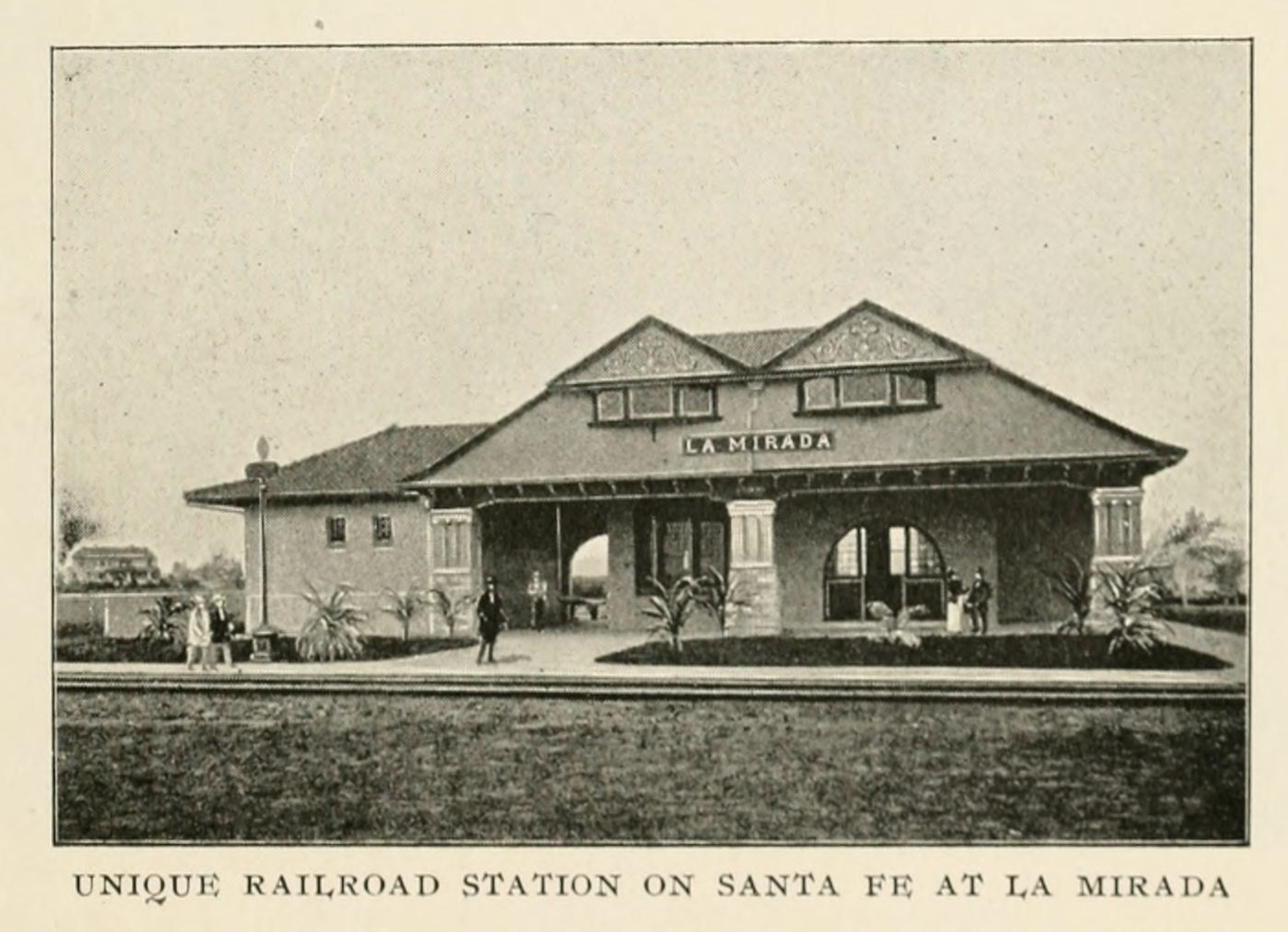
La Mirada (Spanish for "The Look") is a city in southeast Los Angeles County, California United States, and is one of the Gateway Cities. The population was 48,527 at the 2010 census, up from 46,783 at the 2000 census. The La Mirada Theatre for the Performing Arts and the Splash! La Mirada Regional Aquatics Center are two of its main attributes. It is the home of Biola University, an evangelical Christian institution of higher education. History La Mirada (Spanish for ''the look'') was the creation of two men, Andrew McNally, a printer and mapmaker from Chicago (see Rand McNally) and his son-in-law Edwin Neff. In 1888, McNally purchased over of Rancho Los Coyotes, south of Whittier, for $200,000. He developed into his own home called Windermere Ranch and surrounded it with olive, orange and lemon groves. McNally built a plant to process the olive oil, which was of the best quality, as well as a railroad station on Stage Road. From here his olive oil and fruit were shipped ... [...More Info...] [...Related Items...] OR: [Wikipedia] [Google] [Baidu] |
Hawaiian Gardens, California
Hawaiian Gardens is a city in Los Angeles County, California, United States. It is the smallest city in the county in area (approximately 1.0 mi2) and was incorporated on April 9, 1964. The population was 14,254 at the 2010 census, down from 14,779 at the 2000 census. The city's unusual name originated with a 1920s refreshment stand that was decorated with palm fronds and bamboo. It was the then-rural area's main landmark for many years, and its name stuck as the small town grew up around it. As one of seven Los Angeles County cities that allow casino gambling, more than $9.2 million (65%) of the city's revenue comes from the Gardens Casino. Geography Hawaiian Gardens is located at (33.828565, -118.073646). It is bounded by the Los Angeles County cities of Long Beach and Lakewood, and by the Orange County city of Cypress. According to the United States Census Bureau, the city has a total area of . of it is land and of it (1.09%) is water. Hawaiian Gardens is the small ... [...More Info...] [...Related Items...] OR: [Wikipedia] [Google] [Baidu] |
Artesia, California
Artesia (Spanish for "artesian aquifer") is a city in southeast Los Angeles County, California. Artesia was incorporated on May 29, 1959, and is one of Los Angeles County's Gateway Cities. The city has a 2010 census population of 16,522. Artesia is surrounded on the west, south, and east sides by Cerritos, with Norwalk to the north. Artesia is the home of the East West Ice Palace, an ice rink which is co-owned by Michelle Kwan. It was also the childhood home of former First Lady Pat Nixon, who lived there from 1914 to 1931, though the property on which she grew up is now part of neighboring Cerritos. History The village of Artesia was established upon the completion of the Artesia School District on May 3, 1875. It was named for the many flowing artesian wells in the area, which made the village ideal for farming and agriculture. In the 1920s and 1930s, Dutch and Portuguese farmers developed Artesia into one of the most important dairy districts in Southern California. Af ... [...More Info...] [...Related Items...] OR: [Wikipedia] [Google] [Baidu] |
Maywood, California
Maywood is a small Gateway city in Los Angeles County. At , Maywood is the third-smallest incorporated city in Los Angeles County. It is bordered by the cities of Bell on the south, Vernon on the north and west, Huntington Park on the southwest, and Commerce on the east. It is the most densely-populated city in California, and has the highest proportion of Latinos, immigrants, and undocumented immigrants in the county. As of July 1, 2010, Maywood became the first municipality in California to outsource all of its city services, dismantling its police department, laying off all city employees except for the city manager, city attorney and elected officials, and contracting with outside agencies for the provision of all municipal services. The population was 27,395 at the 2010 census. History The land on which Maywood now stands had been populated by Native American tribes for centuries. The area that would later become Maywood was deeded in 1781 by the Spanish monarchy to Span ... [...More Info...] [...Related Items...] OR: [Wikipedia] [Google] [Baidu] |
Huntington Park, California
Huntington Park is a city in the Gateway Cities district of southeastern Los Angeles County, California. As of the 2010 census, the city had a total population of 58,114, of whom 97% are Hispanic/Latino and about half were born outside the U.S. In 2019, Huntington Park was ranked lowest in California and 10th-worst nationally on a so-called “misery index”, based on census data compiled by ''Business Insider'', due to factors such as low household income. Nonetheless, Huntington Park and its Pacific Boulevard area are a busy and dynamic hub of the mostly Hispanic, working-class inner Southeast L.A. area. History Named for prominent industrialist Henry E. Huntington, Huntington Park was incorporated in 1906 as a streetcar suburb on the Los Angeles Railway for workers in the rapidly expanding industries to the southeast of downtown Los Angeles. To this day, about 30% of its residents work at factories in nearby Vernon and Commerce. The stretch of Pacific Boulevard ... [...More Info...] [...Related Items...] OR: [Wikipedia] [Google] [Baidu] |


.jpg)
.jpg)


.jpg)

