|
San Francisco And Oakland Railroad
The San Francisco and Oakland Railroad (SF&O) was built in 1862 to provide ferry-train service from a San Francisco ferry terminal connecting with railroad service through Oakland to San Antonio. In 1868 Central Pacific Railroad decided that Oakland would be the west coast terminus of the First transcontinental railroad and bought SF&O. Beginning November 8, 1869, part of the SF&O line served as the westernmost portion of the transcontinental railroad. It subsequently was absorbed into the Southern Pacific Railroad (SP). The track in Oakland was electrified in 1911 and extended across the San Francisco-Oakland Bay Bridge in 1939. Service was abandoned in 1941. History The San Francisco and Oakland Railroad (and Ferry Co.) was formed in October 1861 under the leadership of Rodman Gibbons and other Oakland residents in order to provide transportation to Oakland by means of a ferry from San Francisco to a small wharf at Oakland Point where passengers could take a train into Oakland. ... [...More Info...] [...Related Items...] OR: [Wikipedia] [Google] [Baidu] |
Northern California
Northern California (colloquially known as NorCal) is a geographic and cultural region that generally comprises the northern portion of the U.S. state of California. Spanning the state's northernmost 48 counties, its main population centers include the San Francisco Bay Area (anchored by the cities of San Jose, San Francisco, and Oakland), the Greater Sacramento area (anchored by the state capital Sacramento), the Redding, California, area south of the Cascade Range, and the Metropolitan Fresno area (anchored by the city of Fresno). Northern California also contains redwood forests, along with most of the Sierra Nevada, including Yosemite Valley and part of Lake Tahoe, Mount Shasta (the second-highest peak in the Cascade Range after Mount Rainier in Washington), and most of the Central Valley, one of the world's most productive agricultural regions. The 48-county definition is not used for the Northern California Megaregion, one of the 11 megaregions of the United States. Th ... [...More Info...] [...Related Items...] OR: [Wikipedia] [Google] [Baidu] |
San Jose, California
San Jose, officially San José (; ; ), is a major city in the U.S. state of California that is the cultural, financial, and political center of Silicon Valley and largest city in Northern California by both population and area. With a 2020 population of 1,013,240, it is the most populous city in both the Bay Area and the San Jose–San Francisco–Oakland, CA Combined Statistical Area, San Jose-San Francisco-Oakland Combined Statistical Area, which contain 7.7 million and 9.7 million people respectively, the List of largest California cities by population, third-most populous city in California (after Los Angeles and San Diego and ahead of San Francisco), and the List of United States cities by population, tenth-most populous in the United States. Located in the center of the Santa Clara Valley on the southern shore of San Francisco Bay, San Jose covers an area of . San Jose is the county seat of Santa Clara County, California, Santa Clara County and the main component of the San ... [...More Info...] [...Related Items...] OR: [Wikipedia] [Google] [Baidu] |
San Francisco Transbay Terminal
The San Francisco Transbay Terminal was a transportation complex in San Francisco, California, United States, roughly in the center of the rectangle bounded north–south by Mission Street and Howard Street, and east–west by Beale Street and 2nd Street in the South of Market area of the city. It opened on January 14, 1939 as a train station and was converted into a bus depot in 1959. The terminal mainly served San Francisco's downtown and Financial District, as transportation from surrounding communities of the Bay Area terminated there such as: Golden Gate Transit buses from Marin County, AC Transit buses from the East Bay, and SamTrans buses from San Mateo County. Long-distance buses from beyond the Bay Area such as Greyhound and Amtrak also served the terminal. Several bus lines of the San Francisco Municipal Railway connected with the terminal. It closed on August 7, 2010, to make way for the construction of the replacement facility, the Transbay Transit Center, and assoc ... [...More Info...] [...Related Items...] OR: [Wikipedia] [Google] [Baidu] |
Interurban Electric Railway
The East Bay Electric Lines were a unit of the Southern Pacific Railroad that operated electric interurban-type trains in the East Bay region of the San Francisco Bay Area.Tufveson.Ford (1977). Beginning in 1862, the SP and its predecessors operated local steam-drawn ferry-train passenger service in the East Bay on an expanding system of lines, but in 1902 the Key SystemSappers (1948).Demoro (Parts 1 and 2). started a competing system of electric lines and ferries. The SP then drew up plans to expand and electrify its system of lines and this new service began in 1911. The trains served the cities of Berkeley, Albany, Emeryville, Oakland, Alameda, and San Leandro transporting commuters to and from the large Oakland Pier (the "mole") and SP Alameda Pier. A fleet of ferry boats ran between these piers and the docks of the Ferry Building on the San Francisco Embarcadero. The East Bay Electric Lines became the Interurban Electric Railway (IER) in anticipation of the opening of th ... [...More Info...] [...Related Items...] OR: [Wikipedia] [Google] [Baidu] |
East Bay (San Francisco Bay Area)
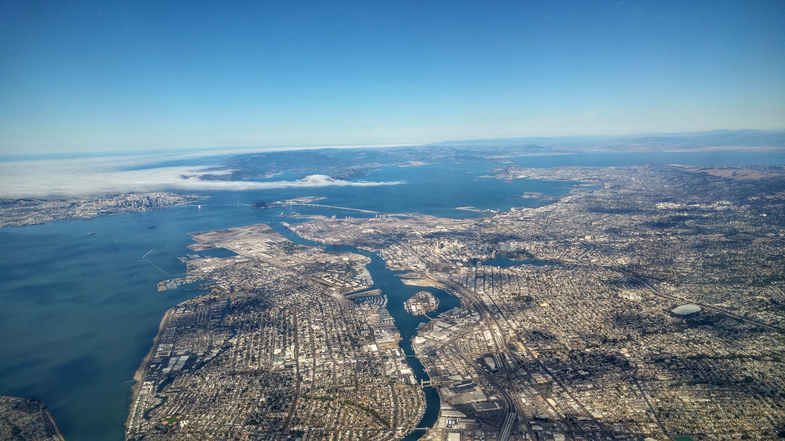
The East Bay is the eastern region of the San Francisco Bay Area and includes cities along the eastern shores of the San Francisco Bay and San Pablo Bay. The region has grown to include inland communities in Alameda and Contra Costa counties. With a population of roughly 2.5 million in 2010, it is the most populous subregion in the Bay Area. Oakland is the largest city in the East Bay and the third largest in the Bay Area. The city serves as a major transportation hub for the U.S. West Coast, and its port is the largest in Northern California. Increased population has led to the growth of large edge cities such as Alameda, Concord, Emeryville, Fremont, Livermore, Pleasanton, San Ramon and Walnut Creek. History and development Although initial development in the larger Bay Area focused on San Francisco, the coastal East Bay came to prominence in the middle of the nineteenth century as the part of the Bay Area most accessible by land from the east. The Transcontinental Rai ... [...More Info...] [...Related Items...] OR: [Wikipedia] [Google] [Baidu] |
Los Angeles
Los Angeles ( ; es, Los Ángeles, link=no , ), often referred to by its initials L.A., is the largest city in the state of California and the second most populous city in the United States after New York City, as well as one of the world's most populous megacities. Los Angeles is the commercial, financial, and cultural center of Southern California. With a population of roughly 3.9 million residents within the city limits , Los Angeles is known for its Mediterranean climate, ethnic and cultural diversity, being the home of the Hollywood film industry, and its sprawling metropolitan area. The city of Los Angeles lies in a basin in Southern California adjacent to the Pacific Ocean in the west and extending through the Santa Monica Mountains and north into the San Fernando Valley, with the city bordering the San Gabriel Valley to it's east. It covers about , and is the county seat of Los Angeles County, which is the most populous county in the United States with an estim ... [...More Info...] [...Related Items...] OR: [Wikipedia] [Google] [Baidu] |
Oakland Pier
The Oakland Long Wharf was an 11,000-foot railroad wharf and ferry pier along the east shore of San Francisco Bay located at the foot of Seventh Street in West Oakland. The Oakland Long Wharf was built, beginning 1868, by the Central Pacific Railroad on what was previously Oakland Point. Beginning November 8, 1869, it served as the west coast terminus of the First transcontinental railroad. In the 1880s, Southern Pacific Railroad took over the CPRR, extending it and creating a new ferry terminal building with the official station name Oakland Pier. The entire structure became commonly and popularly called the Oakland Mole. Portions of the Wharf lasted until the 1960s. The site is now part of the facilities of the Port of Oakland, while passenger service runs to the nearby Jack London Square/Dellums Station History The first use of the site for boats was in 1852, when Gibbons' Wharf was constructed at Gibbons' Point, westward into San Francisco Bay. In 1862, Gibbons' Point ... [...More Info...] [...Related Items...] OR: [Wikipedia] [Google] [Baidu] |
Benicia, California
Benicia ( , ) is a waterside city in Solano County, California, located in the North Bay region of the San Francisco Bay Area. It served as the capital of California for nearly thirteen months from 1853 to 1854. The population was 26,997 at the 2010 United States Census. The city is located along the north bank of the Carquinez Strait. Benicia is just east of Vallejo and across the strait from Martinez. Steve Young, elected in November 2020, is the mayor. History The City of Benicia was founded on May 19, 1847, by Dr. Robert Semple, Thomas O. Larkin, and Comandante General Mariano Guadalupe Vallejo, on land sold to them by General Vallejo in December 1846. It was named for the General's wife, Francisca Benicia Carillo de Vallejo, a member of the Carrillo family of California, a prominent Californio dynasty. The General intended that the city be named "Francisca" after his wife, but this name was dropped when the former city of "Yerba Buena" changed its name to "San Fran ... [...More Info...] [...Related Items...] OR: [Wikipedia] [Google] [Baidu] |
Jack London Square
Jack London Square is an entertainment and business destination on the waterfront of Oakland, California, United States. Named after the author Jack London and owned by the Port of Oakland, it is the home of stores, restaurants, hotels, Amtrak's Jack London Square station, a San Francisco Bay Ferry ferry dock, the historic Heinold's First and Last Chance Saloon, the (re-located) cabin where Jack London lived in the Klondike, and a movie theater. A farmer's market is hosted among the retail shops on Sunday mornings. The former presidential yacht USS ''Potomac'' is moored at an adjacent slip. History The area between Broadway, Webster, First Street (Embarcadero) and the estuary was named Jack London Square in 1951. On May 1, 1951, the area was formally dedicated and a plaque placed at the foot of Broadway. Geography Jack London Square is located at the south end of Broadway, across the Oakland Estuary from Alameda. The name has also come to refer to the formerly industrial ... [...More Info...] [...Related Items...] OR: [Wikipedia] [Google] [Baidu] |
First Transcontinental Railroad
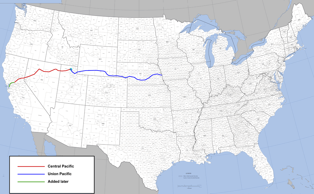
North America's first transcontinental railroad (known originally as the "Pacific Railroad" and later as the " Overland Route") was a continuous railroad line constructed between 1863 and 1869 that connected the existing eastern U.S. rail network at Council Bluffs, Iowa with the Pacific coast at the Oakland Long Wharf on San Francisco Bay. The rail line was built by three private companies over public lands provided by extensive US land grants.Pacific Railroad Act of 1862, §2 & §3 Building was financed by both state and US government subsidy bonds as well as by company issued mortgage bonds.Pacific Railroad Act of 1862, §5 & §6 The Western Pacific Railroad Company built of track from the road's western terminus at Alameda/ Oakland to Sacramento, California. The Central Pacific Railroad Company of California (CPRR) constructed east from Sacramento to Promontory Summit, Utah Territory. The Union Pacific Railroad (UPRR) built from the road's eastern terminus at the Mis ... [...More Info...] [...Related Items...] OR: [Wikipedia] [Google] [Baidu] |
Alameda Terminal
Alameda Terminal (a.k.a. Alameda Wharf) was a railroad station and ferry wharf at the foot and west of present-day Pacific Avenue and Main Street in Alameda, California, on the eastern shore of San Francisco Bay with ferry service to San Francisco. It was built in 1864 and operated by the San Francisco and Alameda Railroad. In 1869, it served as the original west coast terminus of the U.S. First transcontinental railroad, until the opening of Oakland Pier two months later. The western terminus was inaugurated September 6, 1869, when the first Western Pacific through train from Sacramento reached the shores of San Francisco Bay at Alameda Terminal, thus completing the first transcontinental railroad to the Pacific coast. History In 1863, Alfred A. Cohen, a San Francisco lawyer, along with his associates, formulated plans to build a railroad and wharf to carry passengers not only to Alameda, but also by ferry to San Francisco. In 1864, he built a 3,750-foot-long wharf, start ... [...More Info...] [...Related Items...] OR: [Wikipedia] [Google] [Baidu] |
San Leandro, California
San Leandro (Spanish for " St. Leander") is a city in Alameda County, California, United States. It is located in the East Bay of the San Francisco Bay Area; between Oakland to the northwest, and Ashland, Castro Valley, and Hayward to the southeast. The population was 91,008 as of the 2020 census. History Prehistory The first inhabitants of the geographic region that would eventually become San Leandro were the ancestors of the Ohlone people, who arrived sometime between 3500 and 2500 BC. Spanish and Mexican eras The Spanish settlers called these natives ''Costeños'', or 'coast people,' and the English-speaking settlers called them Costanoans. San Leandro was first visited by Europeans on March 20, 1772, by Spanish soldier Captain Pedro Fages and the Spanish Catholic priest Father Crespi. San Leandro is located on the Rancho San Leandro and Rancho San Antonio Mexican land grants. Its name refers to Leander of Seville, a sixth-century Spanish bishop. Both land grants ... [...More Info...] [...Related Items...] OR: [Wikipedia] [Google] [Baidu] |

.png)


.jpg)
.jpg)