|
Salisbury Island , a former island now part of the Port of Durban in South Africa, it is home to Naval Station Durban
{{geodis ...
Salisbury Island may refer to: * Salisbury Island (California), United States * Salisbury Island (Nunavut), Canada *Salisbury Island (Russia) *Salisbury Island (Western Australia), Australia *Iona Island (New York), once known as Salisbury Island *Salisbury Island, Durban Salisbury Island is located inside the Port of Durban on the east coast of South Africa; it is a former island until the Second World War when construction of a naval base connected it to the mainland by a causeway. The island, then a mangrove-cov ... [...More Info...] [...Related Items...] OR: [Wikipedia] [Google] [Baidu] |
Salisbury Island (California)
Salisbury Island (also known as Salsbury Island) is an island in the Old River, in the Sacramento–San Joaquin River Delta. It is named after its original owner, tugboat A tugboat or tug is a marine vessel that manoeuvres other vessels by pushing or pulling them, with direct contact or a tow line. These boats typically tug ships in circumstances where they cannot or should not move under their own power, su ... operator Leslie Salsbury, who purchased it in 1945. It is in Contra Costa County, in northern California. Its coordinates are . References Islands of Contra Costa County, California Islands of the Sacramento–San Joaquin River Delta Islands of Northern California {{ContraCostaCountyCA-geo-stub ... [...More Info...] [...Related Items...] OR: [Wikipedia] [Google] [Baidu] |
Salisbury Island (Nunavut)
Salisbury Island is one of the uninhabited Canadian arctic islands in the Qikiqtaaluk Region, Nunavut. It is located in Hudson Strait, and has an area of .Salisbury Island at Atlas of Canada The Atlas of Canada (french: L'Atlas du Canada) is an online atlas published by Natural Resources Canada that has information on every city, town, village, and hamlet in Canada. It was originally a print atlas, with its first edition being publishe ... References Islands of Baffin Island Islands of Hudson Strait Uninhabited islands of Qikiqtaaluk Region {{QikiqtaalukNU-geo-stub ... [...More Info...] [...Related Items...] OR: [Wikipedia] [Google] [Baidu] |
Salisbury Island (Russia)
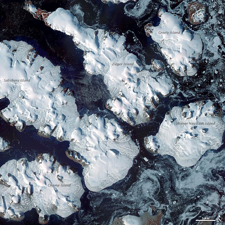
Salisbury Island, (Russian: Остров Солсбери; ''Ostrov Solsberi'') is an island located in the central area of Franz Josef Land, Russia. Geography Salisbury Island is relatively large and long, having a surface of 960 km². Its highest point is 482 m and practically the entire surface of the island is glacierized. Salisbury Island is part of the Zichy Land subgroup of the Franz Josef Archipelago. It has very little open sea around it, being wedged between Luigi Island and Champ Island on its southwestern shores, Ziegler Island in the northeast and Wiener Neustadt Island in the east. The island was named by Frederick George Jackson during his 1894–1897 expedition. A possible source for the name is geology professor Rollin D. Salisbury (1858-1922), of the University of Chicago. Salisbury was second-in-command on the Peary relief expedition. It is also possible that Jackson named the island after Lord Salisbury. Adjacent Islands *Elisabeth Island (Остро ... [...More Info...] [...Related Items...] OR: [Wikipedia] [Google] [Baidu] |
Salisbury Island (Western Australia)
Salisbury Island is located in the Recherche Archipelago off the south coast of Western Australia.Gazetteer of Australia (1996). Belconnen, ACT: Australian Surveying and Land Information Group. The island occupies an area of , the third largest island in the Recherche Archipelago. It is situated approximately east of Esperance and off the coast near the edge of the continental shelf, making it one of the southernmost islands in the archipelago. The island is formed from a massive limestone scarp that sits atop a granite dome. Many caves are found throughout the island both above and below water. Indigenous Australians are thought to have inhabited the island up to 18,000 years ago. Archeologists have found ancient artefacts on the island such as stone blades, lizard traps, axe heads, grinding stones and granite watering holes. The objects are believed to be 5,000 to 18,000 years old from a time when many of the islands were joined to the mainland. ''Rodondo'' was thought ... [...More Info...] [...Related Items...] OR: [Wikipedia] [Google] [Baidu] |
Iona Island (New York)
Iona Island is a island of the Hudson River in the town of Stony Point, New York, on its west bank. The island is located approximately south of the Bear Mountain Bridge and is separated from the Hudson's western shore by mudflats and freshwater tidal marshes. It is part of Bear Mountain State Park, although it is occasionally listed separately as Iona Island State Park. From 1899 to 1947 the island was used as the Naval Ammunition Depot Iona Island. The island and its adjacent marsh were designated a National Natural Landmark in May 1974, and it is part of the Hudson River National Estuarine Research Reserve. It serves mainly as a bird sanctuary, particularly known as a winter nesting place for bald eagles. Geography Iona Island is transected by active River Subdivision (CSX Transportation) railroad tracks, but is accessible to the public only by a causeway connecting it to U.S. Route 9W in Bear Mountain State Park, near Doodletown. It is maintained by the Palisades Inter ... [...More Info...] [...Related Items...] OR: [Wikipedia] [Google] [Baidu] |
