|
Sale Metrolink Station
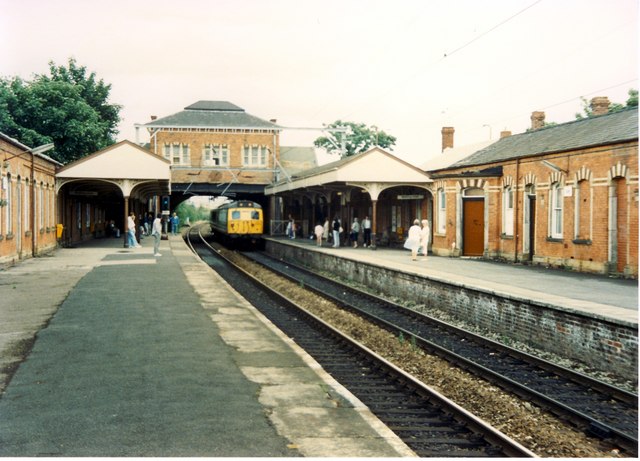
Sale is a tram stop on the Altrincham Line of the Metrolink light-rail system in Sale, Greater Manchester, England. It opened on 15 June 1992 as part of Phase 1 of Metrolink's expansion. Prior to this, it was a railway station on the Manchester, South Junction and Altrincham Railway (MSJAR) line. It was built by John Brogden, who was a local builder in the Sale area. History The station originally opened as Sale on 20 July 1849 by the MSJAR. Renamed as Sale Moor in 1856, as Sale & Ashton on Mersey in 1883 and as Sale in 1931. It closed as a British Rail station on 24 December 1991 and reopened as a Metrolink station on 15 June 1992. Sale tram stop briefly appears during the opening titles of ''Pro Evolution Soccer 2'', which was released in 2002. Services Sale is on the Altrincham Line, with trams towards Altrincham stopping every 6 minutes during the day, Mondays to Saturdays, every 12 minutes Monday to Saturday evenings and Sundays. Trams also head towards Mancheste ... [...More Info...] [...Related Items...] OR: [Wikipedia] [Google] [Baidu] |
Manchester Metrolink
Manchester Metrolink (branded locally simply as Metrolink) is a tram/ light rail system in Greater Manchester, England. The network has 99 stops along of standard-gauge route, making it the most extensive light rail system in the United Kingdom. Metrolink is owned by the public body Transport for Greater Manchester (TfGM) and operated and maintained under contract by a Keolis/ Amey consortium. In 2021/22, 26 million passenger journeys were made on the system. The network consists of eight lines which radiate from Manchester city centre to termini at Altrincham, Ashton-under-Lyne, Bury, East Didsbury, Eccles, Manchester Airport, Rochdale and Trafford Centre. It runs on a mixture of on-street track shared with other traffic; reserved track sections segregated from other traffic, and converted former railway lines. Metrolink is operated by a fleet of 147 high-floor Bombardier M5000 light rail vehicles. Each service runs to a 12-minute headway; stops with more than one serv ... [...More Info...] [...Related Items...] OR: [Wikipedia] [Google] [Baidu] |
Etihad Campus
Etihad Campus is an area of Sportcity, Manchester which is mostly owned and operated by Manchester City Football Club. The campus includes the Etihad Stadium, the City Football Academy (CFA) training facility and club world headquarters, and undeveloped land adjacent to both of these facilities. These two main portions of the campus site are linked by a 60-metre landmark pedestrian walkway/footbridge that spans the junction of Alan Turing Way and Ashton New Road. The term Etihad Campus embraces both the stadium – which already existed when the name was coined in 2010 – as well as much of the surrounding undeveloped land that existed at that time, although the term is also frequently used as a direct synonym for just the CFA portion. The development of the southeastern portion of the Etihad Campus site is focused on the regeneration of the Clayton Aniline site which consists of 80 acres of Brownfield land. The initial phase of the campus development included the constructio ... [...More Info...] [...Related Items...] OR: [Wikipedia] [Google] [Baidu] |
Cheshire Lines Committee
The Cheshire Lines Committee (CLC) was formed in the 1860s and became the second-largest joint railway in Great Britain. The committee, which was often styled the Cheshire Lines Railway, operated of track in the then counties of Lancashire and Cheshire. The railway did not get ''grouped'' into one of the ''Big Four'' during the implementation of the 1923 grouping, surviving independently with its own management until the railways were nationalised at the beginning of 1948. The railway served Liverpool, Manchester, Stockport, Warrington, Widnes, Northwich, Winsford, Knutsford, Chester and Southport with connections to many other railways. Formation The Cheshire Lines Committee evolved in the late 1850s from the close working together of two railways, the Manchester, Sheffield and Lincolnshire Railway (MS&LR) and the Great Northern Railway (GNR); this was in their desire to break the near monopoly on rail traffic held by the London and North Western Railway (LNWR) in the Sou ... [...More Info...] [...Related Items...] OR: [Wikipedia] [Google] [Baidu] |
Diamond Bus North West
Diamond Bus (North West) Ltd., trading as Diamond North West, is a bus operator providing services in the districts of Bolton and Wigan in Greater Manchester operating an extensive commercial network along with tendered services on behalf of Transport for Greater Manchester. It also serves some areas of the districts of Salford and Trafford. The company was founded as ''Green Triangle Buses'' and then subsequently renamed ''South Lancs Travel'' before being purchased by Rotala and rebranded as Diamond North West in 2015. In August 2019, Diamond North West purchased First Manchester's Bolton depot. History South Lancs Travel Green Triangle Buses was established in April 1998 by Martin Bott and David Stewart. The new business began with two new Mercedes-Benz Varios which were used on a Greater Manchester Passenger Transport Executive tender. These were joined by three South Lancashire Transport (also owned by the two partners) single deckers for use on school services. Further ... [...More Info...] [...Related Items...] OR: [Wikipedia] [Google] [Baidu] |
North Manchester General Hospital
North Manchester General Hospital (NMGH) is a large NHS hospital in Crumpsall, North Manchester, England. It is operated by Manchester University NHS Foundation Trust. There is an accident and emergency unit, together with a maternity unit, high dependency unit and a mental health wing. A long-awaited plan to rebuild the hospital was announced publicly by Boris Johnson in the 2019 General Election campaign, and in November 2020 a £54 million funding bid for improvement works was made by the Trust, the city council and Manchester Health and Care Commissioning. History Introduction This extensive hospital site originally housed three separate hospitals: Crumpsall Hospital, Delaunays Hospital and Springfield Hospital. The three amalgamated to create North Manchester General Hospital in 1977. Crumpsall Hospital Crumpsall Hospital was built as an infirmary for the Manchester Union Workhouse and opened in 1876. In 1914 the hospital was a receiving station firstly for 500 casualties ... [...More Info...] [...Related Items...] OR: [Wikipedia] [Google] [Baidu] |
Cheetham Hill
Cheetham is an inner-city area and electoral ward of Manchester, England, which in 2011 had a population of 22,562. It lies on the west bank of the River Irk, north of Manchester city centre, close to the boundary with Salford, bounded by Broughton to the north, Harpurhey to the east, and Piccadilly and Deansgate to the south. Historically part of Lancashire, Cheetham was a township in the parish of Manchester and hundred of Salford. The township was amalgamated into the Borough of Manchester in 1838, and in 1896 became part of the North Manchester township. Cheetham is home to a multi-ethnic community, a result of several waves of immigration to Britain. In the mid-19th century, it attracted Irish people fleeing the Great Famine. It is now home to the Irish World Heritage Centre. Jews settled in the late-19th and early-20th centuries, fleeing persecution in continental Europe. Migrants from the Indian subcontinent and Caribbean settled in the 1950s and 1960s, and more ... [...More Info...] [...Related Items...] OR: [Wikipedia] [Google] [Baidu] |
Manchester City Centre
Manchester City Centre is the central business district of Manchester in Greater Manchester, England situated within the confines of Great Ancoats Street, A6042 Trinity Way, and A57(M) Mancunian Way which collectively form an inner ring road. The City Centre ward had a population of 17,861 at the 2011 census. Manchester city centre evolved from the civilian ''vicus'' of the Roman fort of Mamucium, on a sandstone bluff near the confluence of the rivers Medlock and Irwell. This became the township of Manchester during the Middle Ages, and was the site of the Peterloo Massacre of 1819. Manchester was granted city status in 1853, after the Industrial Revolution, from which the city centre emerged as the global centre of the cotton trade which encouraged its "splendidly imposing commercial architecture" during the Victorian era, such as the Royal Exchange, the Corn Exchange, the Free Trade Hall, and the Great Northern Warehouse. After the decline of the cotton trade and the Ma ... [...More Info...] [...Related Items...] OR: [Wikipedia] [Google] [Baidu] |
Fallowfield
Fallowfield is a suburb of Manchester, England, with a population at the 2011 census of 15,211. Historically in Lancashire, it lies south of Manchester city centre and is bisected east–west by Wilmslow Road and north–south by Wilbraham Road. The former Fallowfield Loop railway line, now a shared use path, follows a route nearly parallel with the east–west main road (Moseley Road/Wilbraham Road). The area has a very large student population. The University of Manchester's main accommodation complex – the Fallowfield Campus – occupies a large area in the north; these are adjacent to the university's Owens Park halls of residence and the Firs Botanical Grounds. In the north-west of the suburb is Platt Fields Park; this is formed from part of the land which once belonged to the Platts of Platt Hall. History The early medieval linear earthwork Nico Ditch passes through Platt Fields Park in Fallowfield and dates from the 8th or 9th century. Ear ... [...More Info...] [...Related Items...] OR: [Wikipedia] [Google] [Baidu] |
Northenden
Northenden is a suburb of Manchester, Greater Manchester, England, with a population of 14,771 at the 2011 census. It lies on the south side of the River Mersey, west of Stockport and south of Manchester city centre, bounded by Didsbury to the north, Gatley to the east, and Wythenshawe to the south and west. Historically a rural township and parish within the hundred of Bucklow in Cheshire, despite unplanned urbanisation and population growth in its neighbours in the 19th century, Northenden remained a comparatively rural and unpopulated area which spanned the hamlets of Lawton Moor, Northern Moor, Rose Hill and a part of what is now Wythenshawe. By 1866 Northenden had coalesced and became a civil parish. The industrialisation of neighbouring Manchester resulted in overpopulation in the early 20th century. Manchester City Council used the Local Government Act 1929 to extend its boundaries to encompass Northenden in 1931 and throughout the mid-20th century it was redeve ... [...More Info...] [...Related Items...] OR: [Wikipedia] [Google] [Baidu] |
Middleton, Greater Manchester
Middleton is a town in the Metropolitan Borough of Rochdale, Greater Manchester, England, on the River Irk southwest of Rochdale and northeast of Manchester city centre. Middleton had a population of 42,972 at the 2011 Census. It lies on the northern edge of Manchester, with Blackley to the south and Moston to the south east. Historically part of Lancashire, Middleton's name comes from it being the centre of several circumjacent settlements. It was an ecclesiastical parish of the hundred of Salford, ruled by aristocratic families. The Church of St Leonard is a Grade I listed building. The Flodden Window in the church's sanctuary is thought to be the oldest war memorial in the United Kingdom, memorialising the archers of Middleton who fought at the Battle of Flodden in 1513. In 1770, Middleton was a village of twenty houses, but in the 18th and 19th centuries it grew into a thriving and populous seat of textile manufacture and it was granted borough status in 1886. Langley ... [...More Info...] [...Related Items...] OR: [Wikipedia] [Google] [Baidu] |
Go North West
Go North West is a bus operator in Greater Manchester, England. It is a subsidiary of the Go-Ahead Group. History Go North West commenced operations on 2 June 2019 following the Go-Ahead Group's purchase of First Greater Manchester's Queens Road depot with 163 vehicles. In December 2022, the Greater Manchester Combined Authority announced that Go North West had won the first round of franchising to run the first Transport for Greater Manchester 'Bee Network' bus services in Bolton and Wigan from September 2023, displacing the operations of Diamond North West and Stagecoach Manchester in both towns. Go North West will take delivery of 50 'Bee Network'-branded Alexander Dennis Enviro400EV battery electric buses for use on these services. Services Go North West operate 25 public services and six school services from the Queens Road depot as of September 2021. It largely serves suburban areas in the north of Manchester along with Salford and Bury. Certain routes have been specifi ... [...More Info...] [...Related Items...] OR: [Wikipedia] [Google] [Baidu] |
Ashton-upon-Mersey
Ashton upon Mersey is an area of the Metropolitan Borough of Trafford, Greater Manchester, England, with a population of 9,693 at the 2011 census. It lies on the south bank of the River Mersey, south of Manchester city centre. Historically part of Cheshire, it became an urban district in 1895 under the Local Government Act 1894. In 1930, the Ashton upon Mersey urban district was abolished and the area became a part of the urban district of Sale. It was part of the Borough of Sale, Cheshire, until 1974. History A 4th century hoard of 46 Roman coins was discovered and is one of four known hoards dating from that period discovered within the Mersey basin. In the 18th century, it was thought that Ashton upon Mersey might have been the site of ''Fines Miaimae et Flaviae'', a Roman station next to the River Mersey. However, this was based on the ''De Situ Britanniae'', a manuscript forged by Charles Bertram, and there is no evidence to suggest any such station existed. "Asht ... [...More Info...] [...Related Items...] OR: [Wikipedia] [Google] [Baidu] |


_2018.png)
_2018.png)
