|
SBIRS-GEO
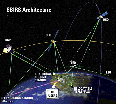
The Space-Based Infrared System (SBIRS) is a United States Space Force system intended to meet the United States' Department of Defense infrared space surveillance needs through the first two to three decades of the 21st century. The SBIRS program is designed to provide key capabilities in the areas of missile warning, missile defense, battlespace characterization and technical intelligence via satellites in geosynchronous Earth orbit (GEO), sensors hosted on satellites in highly elliptical orbit (HEO), and ground-based data processing and control. A total of twelve satellites carrying SBIRS or STSS payloads had been launched: SBIRS GEO-1 ( USA-230, 2011), SBIRS GEO-2 ( USA-241, 2013), SBIRS GEO-3 ( USA-273, 2017), SBIRS GEO-4 ( USA-282, 2018), SBIRS GEO-5 ( USA-315, 2021), SBIRS GEO-6 ( USA-336, 2022), SBIRS HEO-1 ( USA-184, 2006), SBIRS HEO-2 ( USA-200, 2008), SBIRS HEO-3 ( USA-259, 2014), STSS-ATRR ( USA-205, 2009), STSS Demo 1 ( USA-208, 2009) and STSS Demo 2 ( USA-209, 20 ... [...More Info...] [...Related Items...] OR: [Wikipedia] [Google] [Baidu] |
USA-273
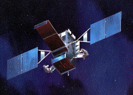
USA-273, also known as SBIRS GEO-3, is a United States military satellite and part of the Space-Based Infrared System (SBIRS). Overview of SBIRS The SBIRS satellites are a replacement for the Defense Support Program (DSP) early warning system. They are intended to detect ballistic missile launches, as well as various other events in the infrared spectrum, including nuclear explosions, aircraft flights, space object entries and reentries, wildfires and spacecraft launches. The mission of SBIRS states that "The SBIRS program was designed to provide a seamless operational transition from DSP to SBIRS and meet jointly-defined requirements of the defense and intelligence communities in support of the missile early warning, missile defense, battlespace awareness and technical intelligence mission areas." Satellite description SBIRS-GEO 3 was manufactured by Lockheed Martin Space and was built upon the A2100M, a militarised, radiation hardened satellite bus that provides ... [...More Info...] [...Related Items...] OR: [Wikipedia] [Google] [Baidu] |
SBIRS-GEO
The Space-Based Infrared System (SBIRS) is a United States Space Force system intended to meet the United States' Department of Defense infrared space surveillance needs through the first two to three decades of the 21st century. The SBIRS program is designed to provide key capabilities in the areas of missile warning, missile defense, battlespace characterization and technical intelligence via satellites in geosynchronous Earth orbit (GEO), sensors hosted on satellites in highly elliptical orbit (HEO), and ground-based data processing and control. A total of twelve satellites carrying SBIRS or STSS payloads had been launched: SBIRS GEO-1 ( USA-230, 2011), SBIRS GEO-2 ( USA-241, 2013), SBIRS GEO-3 ( USA-273, 2017), SBIRS GEO-4 ( USA-282, 2018), SBIRS GEO-5 ( USA-315, 2021), SBIRS GEO-6 ( USA-336, 2022), SBIRS HEO-1 ( USA-184, 2006), SBIRS HEO-2 ( USA-200, 2008), SBIRS HEO-3 ( USA-259, 2014), STSS-ATRR ( USA-205, 2009), STSS Demo 1 ( USA-208, 2009) and STSS Demo 2 ( USA-209, 20 ... [...More Info...] [...Related Items...] OR: [Wikipedia] [Google] [Baidu] |
USA-230
USA-230, also known as SBIRS GEO-1, is a United States military satellite and part of the Space-Based Infrared System. Overview In the mid 1950s, the United States began development of the first space-based missile detection system; the Missile Defense Alarm System (MIDAS), in low Earth orbit. Following the end of the MIDAS programme, plans to deploy an operational system led to the Integrated Missile Early Warning Satellite programme (IMEWS), followed by the Defense Support Program (DSP), The SBIRS satellites are a replacement for the Defense Support Program early warning system. They are intended to detect ballistic missile launches, as well as various other events in the infrared spectrum, including nuclear explosions, aircraft flights, space object entries and reentries, wildfires and spacecraft launches. Satellite description SBIRS-GEO 1 was manufactured by Lockheed Martin Space and is built upon the A2100M satellite bus. Launch SBIRS GEO-1 was launched on 7 M ... [...More Info...] [...Related Items...] OR: [Wikipedia] [Google] [Baidu] |
Atlas V
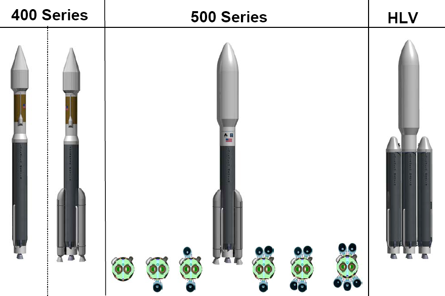
Atlas V is an expendable launch system and the fifth major version in the Atlas (rocket family), Atlas launch vehicle family. It was originally designed by Lockheed Martin, now being operated by United Launch Alliance (ULA), a joint venture between Lockheed Martin and Boeing. Atlas V is also a major NASA launch vehicle. It is America's longest-serving active rocket. In August 2021, ULA announced that Atlas V would be retired, and all 29 remaining launches had been sold. , 19 launches remain. Each Atlas V launch vehicle consists of two main stages. The first stage (rocketry), first stage is powered by a Russian RD-180 engine manufactured by NPO Energomash, Energomash and burning kerosene and liquid oxygen. The Centaur (rocket stage), Centaur upper stage is powered by one or two American RL10 engine(s) manufactured by Aerojet Rocketdyne and burns liquid hydrogen and liquid oxygen. The Star 48 upper stage was used on the ''New Horizons'' mission as a third stage. strap-on booster, ... [...More Info...] [...Related Items...] OR: [Wikipedia] [Google] [Baidu] |
USA-241
USA-241, also known as SBIRS GEO-2, is a United States military satellite and part of the Space-Based Infrared System. Overview The SBIRS satellites are a replacement for the Defense Support Program early warning system. They are intended to detect ballistic missile launches, as well as various other events in the infrared spectrum, including nuclear explosions, aircraft flights, space object entries and reentries, wildfires and spacecraft launches. Satellite description SBIRS-GEO 2 was manufactured by Lockheed Martin Space and is built upon the A2100M satellite bus. Launch SBIRS GEO-2 was launched on 19 March 2013 from Cape Canaveral, atop an Atlas V launch vehicle A launch vehicle or carrier rocket is a rocket designed to carry a payload (spacecraft or satellites) from the Earth's surface to outer space. Most launch vehicles operate from a launch pad, launch pads, supported by a missile launch contro .... Mission In October 2013, the satellite was incorpor ... [...More Info...] [...Related Items...] OR: [Wikipedia] [Google] [Baidu] |
Iraq
Iraq,; ku, عێراق, translit=Êraq officially the Republic of Iraq, '; ku, کۆماری عێراق, translit=Komarî Êraq is a country in Western Asia. It is bordered by Turkey to Iraq–Turkey border, the north, Iran to Iran–Iraq border, the east, the Persian Gulf and Kuwait to the southeast, Saudi Arabia to the south, Jordan to Iraq–Jordan border, the southwest and Syria to Iraq–Syria border, the west. The Capital city, capital and largest city is Baghdad. Iraq is home to diverse ethnic groups including Iraqi Arabs, Kurds, Iraqi Turkmen, Turkmens, Assyrian people, Assyrians, Armenians in Iraq, Armenians, Yazidis, Mandaeans, Iranians in Iraq, Persians and Shabaks, Shabakis with similarly diverse Geography of Iraq, geography and Wildlife of Iraq, wildlife. The vast majority of the country's 44 million residents are Muslims – the notable other faiths are Christianity in Iraq, Christianity, Yazidism, Mandaeism, Yarsanism and Zoroastrianism. The official langu ... [...More Info...] [...Related Items...] OR: [Wikipedia] [Google] [Baidu] |
Gulf War
The Gulf War was a 1990–1991 armed campaign waged by a 35-country military coalition in response to the Iraqi invasion of Kuwait. Spearheaded by the United States, the coalition's efforts against Iraq were carried out in two key phases: Operation Desert Shield, which marked the military buildup from August 1990 to January 1991; and Operation Desert Storm, which began with the aerial bombing campaign against Iraq on 17 January 1991 and came to a close with the American-led Liberation of Kuwait on 28 February 1991. On 2 August 1990, Iraq invaded the neighbouring State of Kuwait and had fully occupied the country within two days. Initially, Iraq ran the occupied territory under a puppet government known as the "Republic of Kuwait" before proceeding with an outright annexation in which Kuwaiti sovereign territory was split, with the "Saddamiyat al-Mitla' District" being carved out of the country's northern portion and the "Kuwait Governorate" covering the rest. Varying spe ... [...More Info...] [...Related Items...] OR: [Wikipedia] [Google] [Baidu] |
Defense Support Program
The Defense Support Program (DSP) is a program of the United States Space Force that operated the reconnaissance satellites which form the principal component of the ''Satellite Early Warning System'' used by the United States. DSP satellites, which are operated by the 460th Space Wing, detect missile or spacecraft launches and nuclear explosions using sensors that detect the infrared emissions from these intense sources of heat. During Desert Storm, for example, DSP was able to detect the launches of Iraqi Scud missiles and provide timely warnings to civilians and military forces in Israel and Saudi Arabia. The satellites are in geosynchronous orbits, and are equipped with infrared sensors operating through a wide-angle Schmidt camera. The entire satellite spins so that the linear sensor array in the focal plane scans over the Earth six times every minute. Typically, DSP satellites were launched on Titan IVB boosters with Inertial Upper Stages. However, one DSP satellite ( ... [...More Info...] [...Related Items...] OR: [Wikipedia] [Google] [Baidu] |
Government Accountability Office
The U.S. Government Accountability Office (GAO) is a legislative branch government agency that provides auditing, evaluative, and investigative services for the United States Congress. It is the supreme audit institution of the federal government of the United States. It identifies its core "mission values" as: accountability, integrity, and reliability. It is also known as the "congressional watchdog". Powers of GAO The work of the GAO is done at the request of congressional committees or subcommittees or is mandated by public laws or committee reports. It also undertakes research under the authority of the Comptroller General. It supports congressional oversight by: * auditing agency operations to determine whether federal funds are being spent efficiently and effectively; * investigating allegations of illegal and improper activities; * reporting on how well government programs and policies are meeting their objectives; * performing policy analyses and outlining options for ... [...More Info...] [...Related Items...] OR: [Wikipedia] [Google] [Baidu] |
USA-205
USA-205, also known as Space Tracking and Surveillance System-Advanced Technology Risk Reduction (STSS-ATRR), and previously as Block 2010 Spacecraft Risk Reduction is a satellite formerly operated by the United States Missile Defense Agency. It was launched to demonstrate new technology for missile detection early warning systems (MDEWS). The technology demonstrated on STSS-ATRR was used in the development of the Space Tracking and Surveillance System (STSS) part of the Space-Based Infrared System (SBIRS). It was launched on a Delta II 7920-10C launch vehicle from Space Launch Complex 2W (SLC-2W) at the Vandenberg Air Force Base (VAFB) in California, at 20:24:25 UTC on 5 May 2009 into a Sun-synchronous orbit (SSO). The launch was conducted by United Launch Alliance United Launch Alliance (ULA), legally United Launch Alliance, LLC, is an American spacecraft launch service provider that manufactures and operates a number of rocket vehicles that are capable of launching spac ... [...More Info...] [...Related Items...] OR: [Wikipedia] [Google] [Baidu] |
Low Earth Orbit
A low Earth orbit (LEO) is an orbit around Earth with a period of 128 minutes or less (making at least 11.25 orbits per day) and an eccentricity less than 0.25. Most of the artificial objects in outer space are in LEO, with an altitude never more than about one-third of the radius of Earth. The term ''LEO region'' is also used for the area of space below an altitude of (about one-third of Earth's radius). Objects in orbits that pass through this zone, even if they have an apogee further out or are sub-orbital, are carefully tracked since they present a collision risk to the many LEO satellites. All crewed space stations to date have been within LEO. From 1968 to 1972, the Apollo program's lunar missions sent humans beyond LEO. Since the end of the Apollo program, no human spaceflights have been beyond LEO. Defining characteristics A wide variety of sources define LEO in terms of altitude. The altitude of an object in an elliptic orbit can vary significantly along the orbit. ... [...More Info...] [...Related Items...] OR: [Wikipedia] [Google] [Baidu] |


