|
Rudnya, Rudnyansky District, Smolensk Oblast
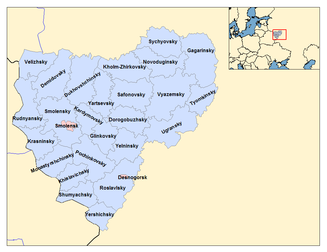
Rudnya (russian: Ру́дня, pl, Rudnia) is a town and the administrative center of Rudnyansky District in Smolensk Oblast, Russia, located on the Malaya Berezina River (Dnieper's basin) northwest of Smolensk, the administrative center of the oblast. Population: History Rudnya (as the settlement of Rodnya) is first mentioned in 1363 since the lands were occupied by Andrei of Polotsk and included in the Principality of Smolensk. During Polish rule it was part of the Vitebsk Voivodeship. After the First Partition of Poland in 1772 the area was included into newly established Babinovichsky Uyezd of Mogilev Governorate. In 1840, the uyezd was abolished and merged into Orshansky Uyezd of the same governorate. In 1919, Mogilev Governorate was abolished, and Orshansky Uyezd was included into Gomel Governorate. In 1920, the uyezd was included into Vitebsk Governorate, and shortly the area was transferred to Smolensky Uyezd of Smolensk Governorate. In 1926, Rudnya was granted t ... [...More Info...] [...Related Items...] OR: [Wikipedia] [Google] [Baidu] |
Smolensk Oblast
Smolensk Oblast (russian: Смоле́нская о́бласть, ''Smolenskaya oblast''; informal name — ''Smolenschina'' (russian: Смоле́нщина)) is a federal subject of Russia (an oblast). Its administrative centre is the city of Smolensk. As of the 2010 Census, its population was 985,537. Geography The oblast was founded on 27 September 1937.Исполнительный комитет Смоленского областного совета народных депутатов. Государственный архив Смоленской области. "Административно-территориальное устройство Смоленской области. Справочник", изд. "Московский рабочий", Москва 1981. Стр. 8 It borders Pskov Oblast in the north, Tver Oblast in the northeast, Moscow Oblast in the east, Kaluga Oblast in south, Bryansk Oblast in the southwest, and Mogilev and Vitebsk Oblast ... [...More Info...] [...Related Items...] OR: [Wikipedia] [Google] [Baidu] |
Vitebsk Voivodeship
Vitebsk Voivodeship ( be, Віцебскае ваяводзтва, pl, Województwo witebskie, la, Palatinatus Vitebsciensis) was a unit of administrative division and local government in the Grand Duchy of Lithuania (from 1569 Polish–Lithuanian Commonwealth) from the 15th century until the partitions of Poland in 1795. Zygmunt Gloger in his monumental book Historical Geography of the Lands of Old Poland provides this description of the Witebsk Voivodeship: “Witebsk (in Latin Vitebscum), located on the Dvina river, was one of main gord of the Principality of Polotsk. In the second half of the 12th century, it emerged as a local center of government. Conquered by one of the sons of Mindaugas in ca. 1239, it became a permanent part of the Grand Duchy of Lithuania since the times of Gediminas. In ca. 1342 Witebsk was already the seat of a starosta, who in the early 16th century were named voivodes. First voivode of Witebsk was Jerzy Chlebowicz (...) The Dvina river divid ... [...More Info...] [...Related Items...] OR: [Wikipedia] [Google] [Baidu] |
Ivan Flyorov
Ivan Andreyevich Flyorov (russian: Иван Андреевич Флёров; 24 April 1905 – 7 October 1941), was a captain in the Red Army in command of the first battery of 8 '' Katyushas'' (BM-8), which was formed in Lipetsk and on 14 July 1941, who was deployed in a battle against the German army at Orsha in Belarus, with devastating effect on the enemy causing massive casualties: a single salvo destroyed several German freight trains with ammunition, fuel, and tanks, annihilating the station itself. The second blow destroyed a bridge across the river Orshica, that connected to Minsk-Moscow highway, simultaneously the German 17th Panzer Division got under a shocking fire blow, as a result of shock damage the 17th Panzer Division of Wehrmacht was unable to recover its forces for more than three days. In autumn 1941, Flyorov's battery was surrounded in the swamps by the Ugra River and heavily shelled by mortars. After running out of ammunition, Captain Flyorov ordered his m ... [...More Info...] [...Related Items...] OR: [Wikipedia] [Google] [Baidu] |
Katyusha Rocket Launcher
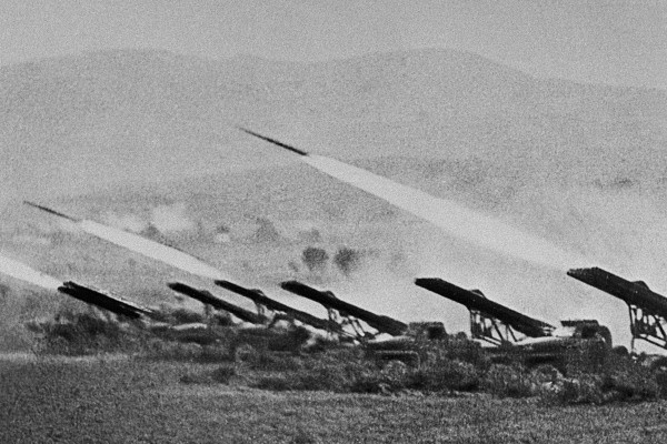
The Katyusha ( rus, Катю́ша, p=kɐˈtʲuʂə, a=Ru-Катюша.ogg) is a type of rocket artillery first built and fielded by the Soviet Union in World War II. Multiple rocket launchers such as these deliver explosives to a target area more intensively than conventional artillery, but with lower accuracy and requiring a longer time to reload. They are fragile compared to artillery guns, but are cheap, easy to produce, and usable on almost any chassis. The Katyushas of World War II, the first self-propelled artillery mass-produced by the Soviet Union,Zaloga, p 150. were usually mounted on ordinary trucks. This mobility gave the Katyusha, and other self-propelled artillery, another advantage: being able to deliver a large blow all at once, and then move before being located and attacked with counter-battery fire. Katyusha weapons of World War II included the BM-13 launcher, light BM-8, and heavy BM-31. Today, the nickname ''Katyusha'' is also applied to newer truck-mounte ... [...More Info...] [...Related Items...] OR: [Wikipedia] [Google] [Baidu] |
Oryol Oblast
Oryol Oblast (russian: Орло́вская о́бласть, ''Orlovskaya oblast''), also known as Orlovshchina (russian: Орловщина) is a federal subjects of Russia, federal subject of Russia (an oblast). Its administrative center is the types of inhabited localities in Russia, city of Oryol. Population: 714,094 (Estimate 2022) (Russian Census (2010), 2010 Census — 786,935). Geography It is located in the southwestern part of the Central Federal District, in the Central Russian Upland. In terms of area, at it is one of the smallest federal subjects. From north to south, it extends for more than , and from west to east—for over . Kaluga Oblast border it to the north-west; Tula Oblast is located to the north; Lipetsk Oblast — to the east; Kursk Oblast — to the south, and Bryansk Oblast is to the west. There are of black earth soils (chernozems) in the oblast, which amounts to three-quarters of the world chernozem reserves. Climate The climate is tempera ... [...More Info...] [...Related Items...] OR: [Wikipedia] [Google] [Baidu] |
Western Oblast
Western Oblast (russian: Западная область, ''Zapadnaya oblast'') was an ''oblast'' (a first-level administrative and municipal unit) of the Russian Soviet Federative Socialist Republic from 1929 to 1937. Its seat was in the city of Smolensk. The oblast was located in the west of European Russia, and its territory is currently divided between Bryansk, Kaluga, Pskov, Smolensk, and Tver Oblasts. By the 1937 All-Union Census, the population of the oblast was 4,693,495 persons. It was abolished on 27 September 1937. History The oblast was established on 1 October 1929 by the All-Russian Central Executive Committee. The territory of the oblast was formed from Smolensk and Bryansk Governorates, parts of Moscow, Kaluga, and Tver Governorates, as well as Velikiye Luki Okrug of Leningrad Oblast. The oblast was subdivided into eight administrative districts (''okrugs''), *Bryansk Okrug (with the seat located in Bryansk); *Klintsy Okrug (Klintsy); *Roslavl Okrug (Roslavl); ... [...More Info...] [...Related Items...] OR: [Wikipedia] [Google] [Baidu] |
Smolensk Okrug
Smolensk ( rus, Смоленск, p=smɐˈlʲensk, a=smolensk_ru.ogg) is a city and the administrative center of Smolensk Oblast, Russia, located on the Dnieper River, west-southwest of Moscow. First mentioned in 863, it is one of the oldest cities in Russia. Population: The city has been destroyed several times throughout its long history because it was on the invasion routes of various empires. Smolensk is known for its electronics, textiles, food processing, and diamond faceting industries. Etymology The name of the city is derived from the name of the Smolnya River. Smolnya river flows through Karelian and Murmansk areas of north-western Russia. The origin of the river's name is less clear. One possibility is the old Slavic word () for black soil, which might have colored the waters of the Smolnya. An alternative origin could be the Russian word (), which means resin, tar, or pitch. Pine trees grow in the area, and the city was once a center of resin processing and t ... [...More Info...] [...Related Items...] OR: [Wikipedia] [Google] [Baidu] |
Smolensk Governorate
Smolensk Governorate (russian: Смоленская губерния, Smolenskaja gubernija), or the Government of Smolensk, was an administrative division (a '' guberniya'') of the Tsardom of Russia, the Russian Empire, and the Russian SFSR. It existed, with interruptions, between 1708 and 1929. Smolensk Governorate, together with seven other governorates, was established on , 1708, by an edict from Tsar Peter the Great.Указ об учреждении губерний и о росписании к ним городов As with the rest of the governorates, neither the borders nor internal subdivisions of Smolensk Governorate were defined; instead, the territory was defined as a set of cities, and section of lands adjacent to those ... [...More Info...] [...Related Items...] OR: [Wikipedia] [Google] [Baidu] |
Smolensky Uyezd
Smolensky Uyezd (''Смоленский уезд'') was one of the subdivisions of the Smolensk Governorate of the Russian Empire. It was situated in the central part of the governorate. Its administrative centre was Smolensk. Demographics At the time of the Russian Empire Census of 1897, Smolensky Uyezd had a population of 145,155. Of these, 91.1% spoke Russian, 3.1% Yiddish, 2.6% Polish, 1.2% Belarusian, 0.7% Ukrainian, 0.5% Latvian, 0.4% German, 0.1% Tatar, 0.1% Lithuanian and 0.1% Romani Romani may refer to: Ethnicities * Romani people, an ethnic group of Northern Indian origin, living dispersed in Europe, the Americas and Asia ** Romani genocide, under Nazi rule * Romani language, any of several Indo-Aryan languages of the Roma ... as their native language. Демоскоп Weekly - Приложение. Справочник статист ... [...More Info...] [...Related Items...] OR: [Wikipedia] [Google] [Baidu] |
Vitebsk Governorate
Vitebsk Governorate (russian: Витебская губерния, ) was an administrative unit ( guberniya) of the Russian Empire, with the seat of governorship in Vitebsk. It was established in 1802 by splitting the Byelorussia Governorate and existed until 1924. Today most of the area belongs to Belarus, the northwestern part to Latvia and the northeastern part to Pskov and Smolensk Oblasts of Russia.Together with the Vilna, Kovno, Grodno, Minsk, and Mogilev Governorates, it formed the Northwestern Krai. The provincial city was Vitebsk, the largest city was Dvinsk. On January 1, 1919, the Provisional Revolutionary Government issued a manifesto proclaiming the formation of the Socialist Soviet Republic of Belarus (SSRB) within the RSFSR, which included the Vitebsk, Grodno, Mogilev, Minsk and Smolensk provinces. On January 16, 1919 by the decision of the Central Committee of the RCP the Vitebsk, Mogilev and Smolensk provinces were returned into direct subordination to the RSFS ... [...More Info...] [...Related Items...] OR: [Wikipedia] [Google] [Baidu] |
Gomel Governorate
Gomel Governorate was an administrative division (a '' guberniya'') of the Russian Soviet Federative Socialist Republic from 1919 to 1926. Its capital was Gomel.http://www.jewishgen.org/belarus/borders_timeline.htm It was formed from nine uyezds of the abolished Mogilev Governorate, one uyezd of Minsk Governorate and four uyezds of Chernigov Governorate. At its establishment, Gomel Governorate was made up of fourteen uyezds: *Bykhovsky Uyezd *Gomelsky Uyezd *Goretsky Uyezd * Klimovichsky Uyezd *Mglinsky Uyezd with Pochepsky District * Mogilyovsky Uyezd *Novozybkovsky Uyezd *Orshansky Uyezd *Rechitsky Uyezd *Rogachyovsky Uyezd * Starodubsky Uyezd * Surazhsky Uyezd *Chaussky Uyezd *Cherikovsky Uyezd In 1920, Orshansky Uyezd was transferred to Vitebsk Governorate. In 1921, Surazhsky Uyezd was renamed Klintsovsky. In 1922, Goretsky Uyezd became a part of Smolensk Governorate. On May 4, Mglinsky and Cherikovsky Uyezds were abolished and new Pochepsky District was established. On ... [...More Info...] [...Related Items...] OR: [Wikipedia] [Google] [Baidu] |
Orshansky Uyezd
Orshansky Uyezd (''Оршанский уезд'') was one of the subdivisions of the Mogilev Governorate of the Russian Empire. It was situated in the northern part of the governorate. Its administrative centre was Orsha. Demographics At the time of the Russian Empire Census of 1897, Orshansky Uyezd had a population of 187,068. Of these, 79.9% spoke Belarusian, 12.1% Yiddish, 2.6% Russian, 2.0% Latvian, 1.8% Polish, 0.8% Lithuanian, 0.3% German German(s) may refer to: * Germany (of or related to) ** Germania (historical use) * Germans, citizens of Germany, people of German ancestry, or native speakers of the German language ** For citizens of Germany, see also German nationality law **Ge ... and 0.3% Estonian as their native language. Демоскоп Weekly - Приложение. Справочник статистических показат ... [...More Info...] [...Related Items...] OR: [Wikipedia] [Google] [Baidu] |


