|
Rochers-de-Naye
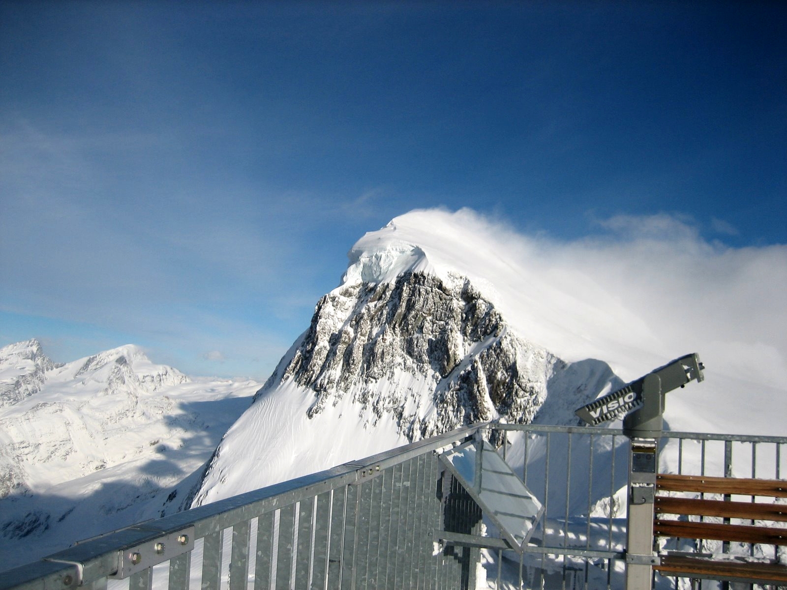
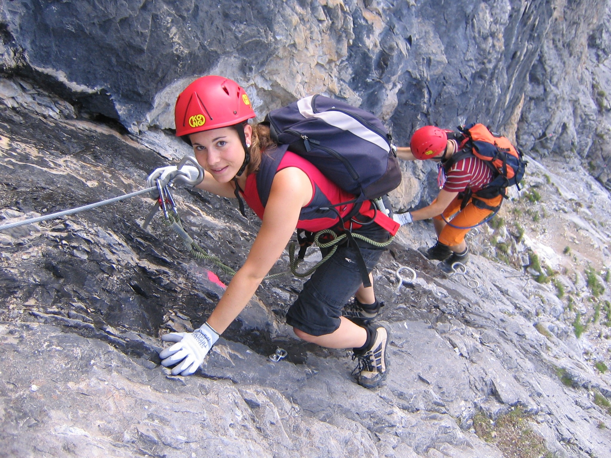
The Rochers de Naye (French, lit. "rocks of Naye"; ) is a mountain of the Swiss Alps, overlooking Lake Geneva near Montreux and Villeneuve, in the canton of Vaud. They lie on the range separating the basin of Lake Geneva from the valley of the Sarine, on the watershed between the Rhone and the Rhine. The mountain is partially located in the canton of Fribourg, the border between the two cantons culminating on a lower summit named ''Grande Chaux de Naye'' (). The Rochers de Naye are easily accessible from Montreux, where the highest railway in the canton, the Montreux–Glion–Rochers-de-Naye railway line, starts. From the summit station (), only a short walk is necessary to reach the summit. In addition, it is also possible to access the summit by driving to Col de Jaman and then making the 2-3 hr hike to the peak. The Rochers de Naye are also known for the Rochers de Naye Via Ferrata [...More Info...] [...Related Items...] OR: [Wikipedia] [Google] [Baidu] |
Montreux–Glion–Rochers-de-Naye Railway Line
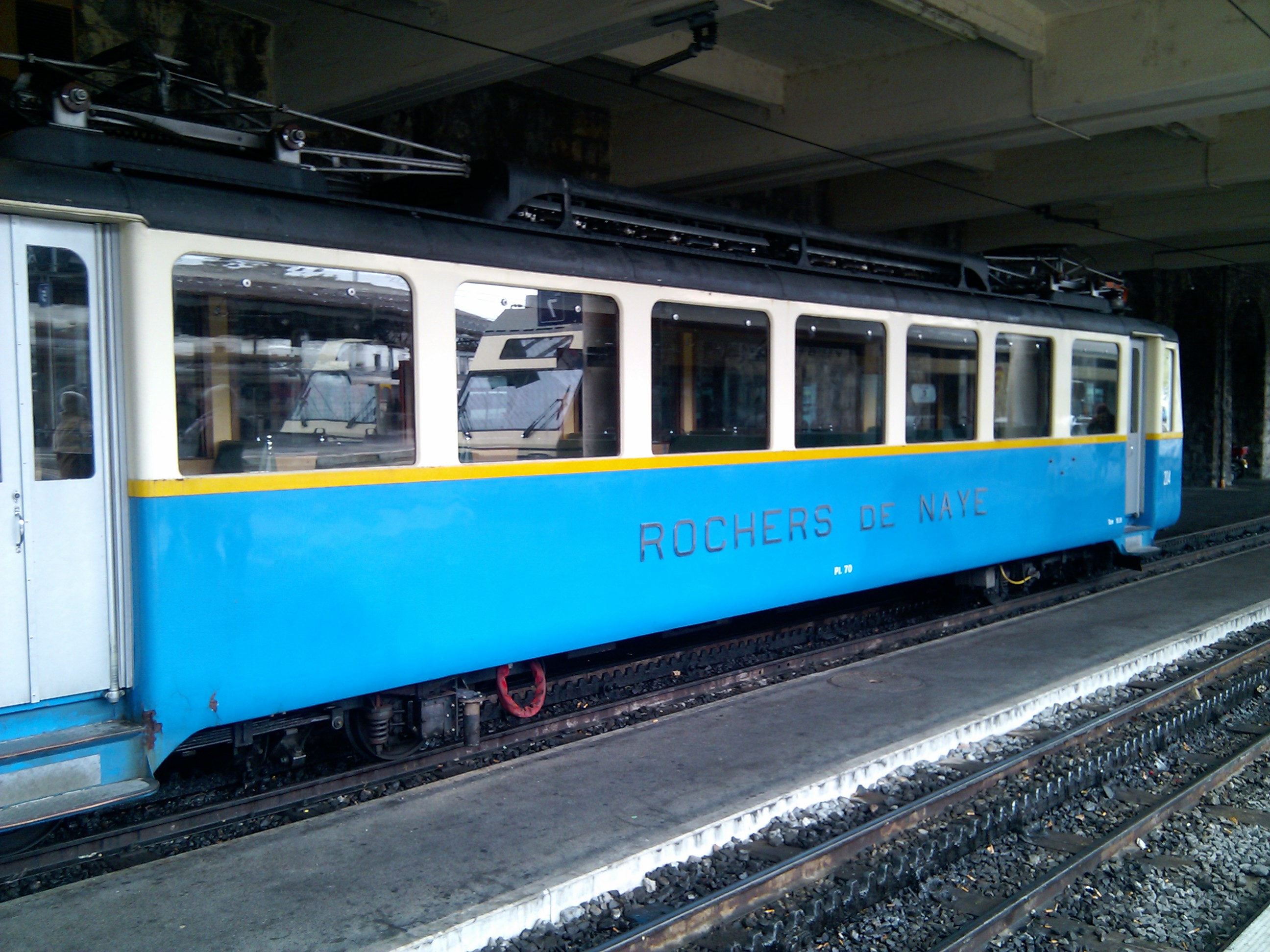
The Montreux–Glion–Rochers-de-Naye railway line is an electrically operated rack railway in Switzerland with a track gauge of . The line connects the resort of Montreux, on the shores of Lake Geneva, with the summit of the Rochers de Naye mountain. The line operates via the village of Glion, on the mountainside above Montreux, where it connects with the Territet–Glion funicular. The line was originally built as two separate lines by two different companies, the Chemin de fer Glion–Rochers-de-Naye (GN) and the Chemin de fer Montreux–Glion (MGI). Today, the line is owned and operated by Transports Montreux–Vevey–Riviera. Since 2017, the line is operated with original Belle Epoque carriages preserved and restored by the MOB company. History Glion to Rochers-de-Naye The first section of the line to open was the Glion to Rochers-de-Naye railway, which was built by the ''Chemin de fer Glion–Rochers-de-Naye'' company (GN), and opened in 1892. Initially G ... [...More Info...] [...Related Items...] OR: [Wikipedia] [Google] [Baidu] |
Montreux
Montreux (, , ; frp, Montrolx) is a Swiss municipality and town on the shoreline of Lake Geneva at the foot of the Alps. It belongs to the district of Riviera-Pays-d'Enhaut in the canton of Vaud in Switzerland, and has a population of approximately 26,433, with about 85,000 in the agglomeration Vevey-Montreux as 2019. Located in the centre of a region named ''Riviera'' (french: Riviera vaudoise), Montreux has been an important tourist destination since the 19th century due to its mild climate. The region includes numerous Belle Époque palaces and hotels near the shores of Lake Geneva. Montreux railway station is a stop on the Simplon Railway and is a mountain railway hub. History The earliest settlement was a Late Bronze Age village at Baugy. Montreux lies on the north east shore of Lake Geneva at the fork in the Roman road from Italy over the Simplon Pass, where the roads to the Roman capital of Aventicum and the road into Gaul through Besançon separated. This made it an i ... [...More Info...] [...Related Items...] OR: [Wikipedia] [Google] [Baidu] |
Marmot
Marmots are large ground squirrels in the genus ''Marmota'', with 15 species living in Asia, Europe, and North America. These herbivores are active during the summer, when they can often be found in groups, but are not seen during the winter, when they hibernate underground. They are the heaviest members of the squirrel family. Description Marmots are large rodents with characteristically short but robust legs, enlarged claws which are well adapted to digging, stout bodies, and large heads and incisors to quickly process a variety of vegetation. While most species are various forms of earthen-hued brown, marmots vary in fur coloration based roughly on their surroundings. Species in more open habitat are more likely to have a paler color, while those sometimes found in well-forested regions tend to be darker. Marmots are the heaviest members of the squirrel family. Total length varies typically from about and body mass averages about in spring in the smaller species and in aut ... [...More Info...] [...Related Items...] OR: [Wikipedia] [Google] [Baidu] |
Swisstopo
Swisstopo is the official name for the Swiss Federal Office of Topography (in German language, German: ''Bundesamt für Landestopografie''; French language, French: ''Office fédéral de topographie''; Italian language, Italian: ''Ufficio federale di topografia''; Romansh language, Romansh: ''Uffizi federal da topografia''), Switzerland's national mapping agency. The current name was made official in 2002. It had been in use as the domain name for the institute's homepage, swisstopo.ch, since 1997. Maps The main class of products produced by Swisstopo are topographical maps on seven different Scale (map), scales. Swiss maps have been praised for their accuracy and quality. Regular maps * 1:25.000. This is the most detailed map, useful for many purposes. Those are popular with tourists, especially for famous areas like Zermatt and St. Moritz. These maps cost CHF 13.50 each (2004). 208 maps on this scale are published at regular intervals. The first map published on this scale ... [...More Info...] [...Related Items...] OR: [Wikipedia] [Google] [Baidu] |
Rhine
), Surselva, Graubünden, Switzerland , source1_coordinates= , source1_elevation = , source2 = Rein Posteriur/Hinterrhein , source2_location = Paradies Glacier, Graubünden, Switzerland , source2_coordinates= , source2_elevation = , source_confluence = Reichenau , source_confluence_location = Tamins, Graubünden, Switzerland , source_confluence_coordinates= , source_confluence_elevation = , mouth = North Sea , mouth_location = Netherlands , mouth_coordinates = , mouth_elevation = , progression = , river_system = , basin_size = , tributaries_left = , tributaries_right = , custom_label = , custom_data = , extra = The Rhine ; french: Rhin ; nl, Rijn ; wa, Rén ; li, Rien; rm, label= Sursilvan, Rein, rm, label= Sutsilvan and Surmiran, Ragn, rm, label=Rumantsch Grischun, Vallader and Puter, Rain; it, Reno ; gsw, Rhi(n), inclu ... [...More Info...] [...Related Items...] OR: [Wikipedia] [Google] [Baidu] |
Mountains Of The Canton Of Vaud
A mountain is an elevated portion of the Earth's crust, generally with steep sides that show significant exposed bedrock. Although definitions vary, a mountain may differ from a plateau in having a limited summit area, and is usually higher than a hill, typically rising at least 300 metres (1,000 feet) above the surrounding land. A few mountains are isolated summits, but most occur in mountain ranges. Mountains are formed through tectonic forces, erosion, or volcanism, which act on time scales of up to tens of millions of years. Once mountain building ceases, mountains are slowly leveled through the action of weathering, through slumping and other forms of mass wasting, as well as through erosion by rivers and glaciers. High elevations on mountains produce colder climates than at sea level at similar latitude. These colder climates strongly affect the ecosystems of mountains: different elevations have different plants and animals. Because of the less hospitable terrain and ... [...More Info...] [...Related Items...] OR: [Wikipedia] [Google] [Baidu] |
Mountains Of The Alps
This page tabulates only the most prominent mountains of the Alps, selected for having a topographic prominence of ''at least'' , and all of them exceeding in height. Although the list contains 537 summits, some significant alpine mountains are necessarily excluded for failing to meet the stringent prominence criterion. The list of these most prominent mountains is continued down to 2500 m elevation at List of prominent mountains of the Alps (2500–2999 m) and down to 2000 m elevation on List of prominent mountains of the Alps (2000–2499 m). All such mountains are located in either France, Italy, Switzerland, Liechtenstein, Austria, Germany or Slovenia, even in some lower regions. Together, these three lists include all 44 ultra-prominent peaks of the Alps, with 19 ultras over 3000m on this page. For a definitive list of all 82 the highest peaks of the Alps, as identified by the International Climbing and Mountaineering Federation (UIAA), and often referred to as the 'Alpi ... [...More Info...] [...Related Items...] OR: [Wikipedia] [Google] [Baidu] |
Two-thousanders Of Switzerland
Two-thousanders are mountains that have a height of at least 2,000 metres above sea level, but less than 3,000 metres. The term is used in Alpine circles, especially in Europe (e.g. German: ''Zweitausender''). The two photographs show two typical two-thousanders in the Alps that illustrate different types of mountain. The Säuling (top) is a prominent, individual peak, whereas the Schneeberg (bottom) is an elongated limestone massif. In ranges like the Allgäu Alps, the Gesäuse or the Styrian-Lower Austrian Limestone Alps the mountain tour descriptions for mountaineers or hikers commonly include the two-thousanders, especially in areas where only a few summits exceed this level. Examples from these regions of the Eastern Alps are: * the striking Nebelhorn (2,224 m) near Oberstdorf or the Säuling (2,047 m) near Neuschwanstein, * the Admonter Reichenstein (2,251 m), Eisenerzer Reichenstein (2,165 m), Großer Pyhrgas (2,244 m) or Hochtor (2,369&nbs ... [...More Info...] [...Related Items...] OR: [Wikipedia] [Google] [Baidu] |
List Of Mountains Of Switzerland Accessible By Public Transport
This is a list of mountains of Switzerland above 800 metres whose summits are accessible by public transport. This list includes mountains with a topographic prominence of at least 30 metres that have a station above the height of their key col and within 120 metres (height difference) from the summit. The station can be reached by cable car, funicular, railway or bus. This list notably includes the Klein Matterhorn and the Säntis, respectively the highest and the most prominentInformation retrieved on 5 March 2014 froCore Europe 50 Most Prominent Peaks (peakbagger.com)an/ref> peaks of Europe with public transport access. It also includes the Chasseral, the most isolated summit of the country accessible to pedestrians. This list does not include ski lifts. For a list of ski areas, see List of ski areas and resorts in Switzerland. For a general list of mountains, see List of mountains of Switzerland. List See also *List of aerial tramways in Switzerland *List of funiculars ... [...More Info...] [...Related Items...] OR: [Wikipedia] [Google] [Baidu] |
Via Ferrata
A via ferrata (Italian for "iron path", plural ''vie ferrate'' or in English ''via ferratas'') is a protected climbing route found in the Alps and certain other locations. The term "via ferrata" is used in most countries and languages except notably in German-speaking regions, which use ''Klettersteig''—"climbing path" (plural ''Klettersteige''). Infrastructure A via ferrata is a climbing route that employs steel cables, rungs or ladders, fixed to the rock to which the climbers affix a harness with two leashes, which allows the climbers to secure themselves to the metal fixture and limit any fall. The cable and other fixtures, such as iron rungs (stemples), pegs, carved steps, and ladders and bridges, provide both footings and handholds, as well. This allows climbing on otherwise dangerous routes without the risks of unprotected scrambling and climbing or the need for technical climbing equipment. They expand the opportunities for accessing difficult peaks as an alternative ... [...More Info...] [...Related Items...] OR: [Wikipedia] [Google] [Baidu] |
Col De Jaman
The Col de Jaman (1,512 m) is a mountain pass in the western Swiss Alps, connecting Montreux in the canton of Vaud to Montbovon in the canton of Fribourg. The pass itself, overlooked by the Dent de Jaman, is located within the canton of Vaud, the border with the canton of Fribourg running one kilometre east. The pass is connected to Les Avants by a paved road. A railway tunnel ( Montreux–Oberland Bernois railway) runs below the pass. See also *List of mountain passes in Switzerland References External linksCol de Jaman on Hikr Jaman Jaman Jaman was a company that offered users a movie discovery site, allowing them to browse viewing options offered across the internet. In its previous iteration, Jaman was one of the first sites to offer view on demand of media on the internet. It ... Mountain passes of the canton of Vaud Rail mountain passes of Switzerland {{Vaud-geo-stub ... [...More Info...] [...Related Items...] OR: [Wikipedia] [Google] [Baidu] |
Canton Of Fribourg
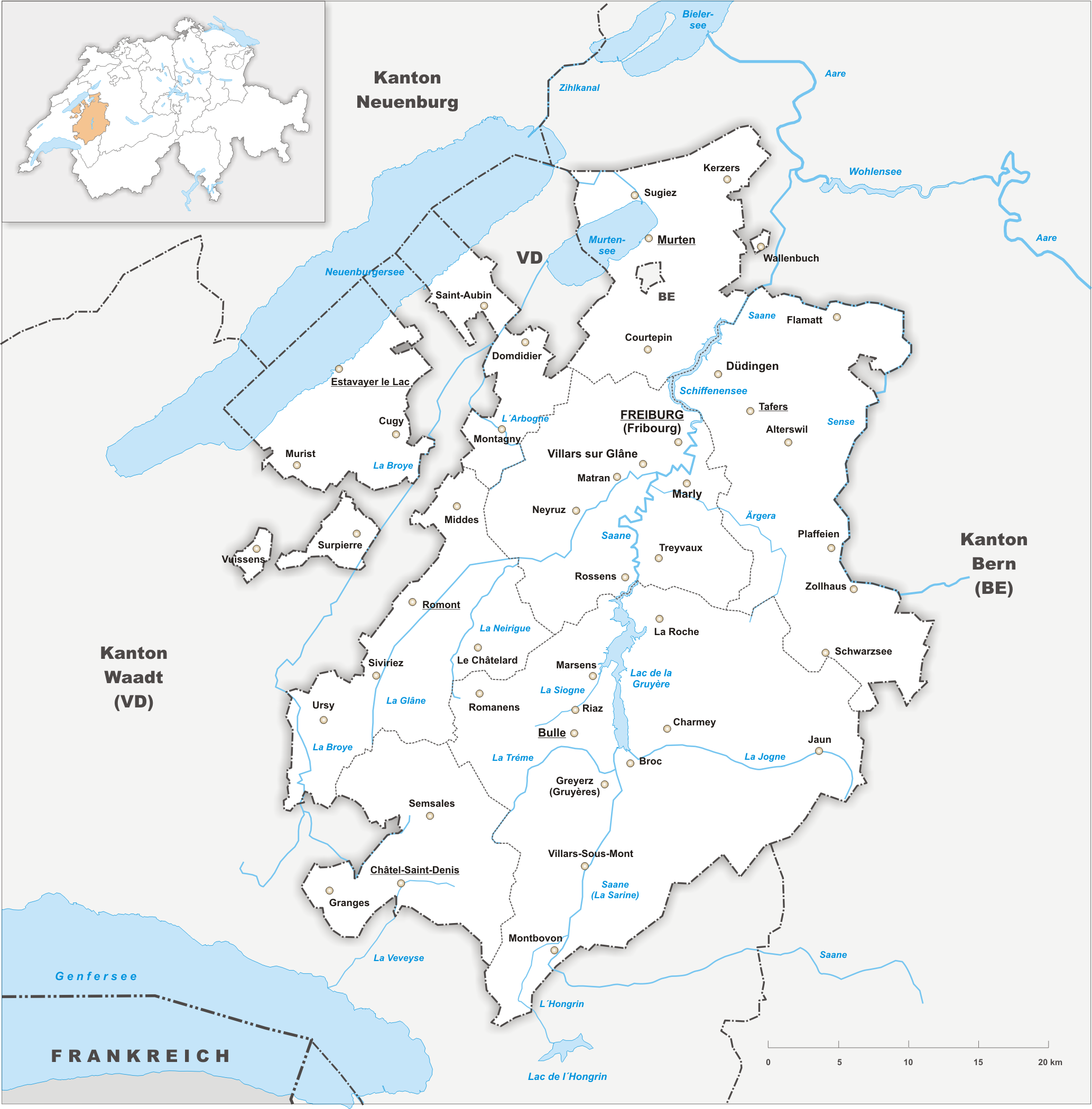
The canton of Fribourg, also canton of Freiburg (french: Canton de Fribourg ; german: Kanton Freiburg ; frp, Canton de Fribôrg rm, Chantun Friburg it, Canton Friburgo) is located in western Switzerland. The canton is bilingual, with French spoken by more than two thirds of the citizens and German by a little more than a quarter. Both are official languages in the canton. The canton takes its name from its capital city of Fribourg. History On the shores of Lake Neuchâtel and Lake Morat significant traces of prehistoric settlements have been unearthed. The canton of Fribourg joined the Swiss Confederation in 1481. The area is made up of lands acquired by the capital Fribourg. The present extent was reached in 1803 when Murten (Morat) was acquired. The canton of Fribourg joined the separatist league of Catholic cantons in 1846 (Sonderbund). The following year, its troops surrendered to the federal army. Geography The canton is bounded to the west by Lake Neuchâtel, to the ... [...More Info...] [...Related Items...] OR: [Wikipedia] [Google] [Baidu] |


