|
Rochdale (ancient Parish)
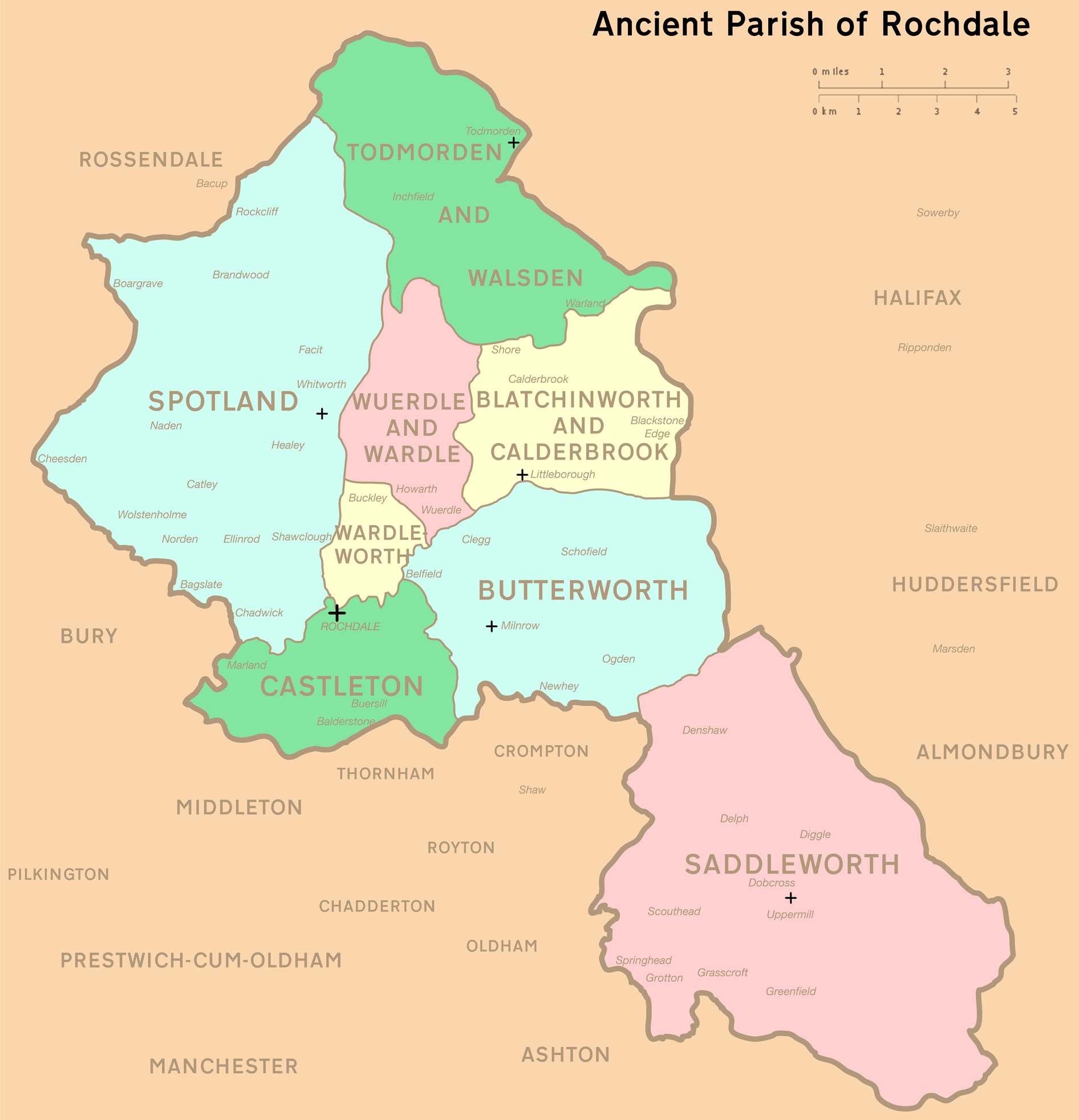
Rochdale was an ecclesiastical parish of early-medieval origin in northern England, administered from the Church of St Chad, Rochdale. At its zenith, it occupied of land amongst the South Pennines, and straddled the historic county boundary between Lancashire and the West Riding of Yorkshire. To the north and north-west was the parish of Whalley; to the southwest was the parish of Bury; to the south was Middleton and Prestwich-cum-Oldham. Anciently a dependency of Whalley Abbey, the parish of Rochdale is believed to be of Anglo-Saxon origin, as evidenced by historical documentation, toponymy and its dedication to Chad of Mercia. Urbanisation, population shifts, and local government reforms all contributed towards the gradual alteration and ultimate dissolution of the historic parish boundaries; the social welfare functions of the parish were broadly superseded by the English Poor Laws and new units of local governance, such as the County Borough of Rochdale and the Milnrow Ur ... [...More Info...] [...Related Items...] OR: [Wikipedia] [Google] [Baidu] |
Rochdale
Rochdale ( ) is a large town in Greater Manchester, England, at the foothills of the South Pennines in the dale on the River Roch, northwest of Oldham and northeast of Manchester. It is the administrative centre of the Metropolitan Borough of Rochdale, which had a population of 211,699 in the 2011 census. Located within the historic boundaries of the county of Lancashire. Rochdale's recorded history begins with an entry in the Domesday Book of 1086 under "Recedham Manor". The ancient parish of Rochdale was a division of the hundred of Salford and one of the largest ecclesiastical parishes in England, comprising several townships. By 1251, Rochdale had become important enough to have been granted a Royal charter. Rochdale flourished into a centre of northern England's woollen trade, and by the early 18th century was described as being "remarkable for many wealthy merchants". Rochdale rose to prominence in the 19th century as a mill town and centre for textile manufacture ... [...More Info...] [...Related Items...] OR: [Wikipedia] [Google] [Baidu] |
Northern England
Northern England, also known as the North of England, the North Country, or simply the North, is the northern area of England. It broadly corresponds to the former borders of Angle Northumbria, the Anglo-Scandinavian Kingdom of Jorvik, and the Celt Britonic Yr Hen Ogledd Kingdoms. The common governmental definition of the North is a grouping of three statistical regions: the North East, the North West, and Yorkshire and the Humber. These had a combined population of 14.9 million at the 2011 census, an area of and 17 cities. Northern England is culturally and economically distinct from both the Midlands and the South of England. The area's northern boundary is the border with Scotland, its western the border with Wales, and its eastern the North Sea; there are varying interpretations of where the southern border with the Midlands lies culturally; the Midlands is often also split by closeness to the North and the South. Many Industrial Revolution innovations began in N ... [...More Info...] [...Related Items...] OR: [Wikipedia] [Google] [Baidu] |
English Poor Laws
The English Poor Laws were a system of poor relief in England and Wales that developed out of the codification of late-medieval and Tudor-era laws in 1587–1598. The system continued until the modern welfare state emerged after the Second World War. English Poor Law legislation can be traced back as far as 1536, when legislation was passed to deal with the impotent poor, although there were much earlier Plantagenet laws dealing with the problems caused by vagrants and beggars. The history of the Poor Law in England and Wales is usually divided between two statutes: the Old Poor Law passed during the reign of Elizabeth I (1558–1603) and the New Poor Law, passed in 1834, which significantly modified the system of poor relief. The New Poor Law altered the system from one which was administered haphazardly at a local parish level to a highly centralised system which encouraged the large-scale development of workhouses by poor law unions. The Poor Law system fell into decline at ... [...More Info...] [...Related Items...] OR: [Wikipedia] [Google] [Baidu] |
Urbanisation
Urbanization (or urbanisation) refers to the population shift from rural to urban areas, the corresponding decrease in the proportion of people living in rural areas, and the ways in which societies adapt to this change. It is predominantly the process by which towns and cities are formed and become larger as more people begin living and working in central areas. Although the two concepts are sometimes used interchangeably, urbanization should be distinguished from urban growth. Urbanization refers to the ''proportion'' of the total national population living in areas classified as urban, whereas urban growth strictly refers to the ''absolute'' number of people living in those areas. It is predicted that by 2050 about 64% of the developing world and 86% of the developed world will be urbanized. That is equivalent to approximately 3 billion urbanites by 2050, much of which will occur in Africa and Asia. Notably, the United Nations has also recently projected that nearly all globa ... [...More Info...] [...Related Items...] OR: [Wikipedia] [Google] [Baidu] |
Chad Of Mercia
Chad of Mercia (died 2 March 672) was a prominent 7th-century Anglo-Saxon Catholic monk who became abbot of several monasteries, Bishop of the Northumbrians and subsequently Bishop of the Mercians and Lindsey People. He was later canonised as a saint. He was the brother of Cedd, also a saint. He features strongly in the work of the Venerable Bede and is credited, together with Cedd, with introducing Christianity to the Mercian kingdom. Sources Most of our knowledge of Chad comes from the writings of the Venerable Bede. Bede tells us that he obtained his information about Chad and his brother, Cedd, from the monks of Lastingham, where both were abbots. Bede also refers to information he received from Trumbert, "who tutored me in the Scriptures and who had been educated in the monastery by that master", i.e. Chad. In other words, Bede considered himself to stand in the spiritual lineage of Chad and had gathered information from at least one who knew him personally. Early ... [...More Info...] [...Related Items...] OR: [Wikipedia] [Google] [Baidu] |
Anglo-Saxon
The Anglo-Saxons were a Cultural identity, cultural group who inhabited England in the Early Middle Ages. They traced their origins to settlers who came to Britain from mainland Europe in the 5th century. However, the ethnogenesis of the Anglo-Saxons happened within Britain, and the identity was not merely imported. Anglo-Saxon identity arose from interaction between incoming groups from several Germanic peoples, Germanic tribes, both amongst themselves, and with Celtic Britons, indigenous Britons. Many of the natives, over time, adopted Anglo-Saxon culture and language and were assimilated. The Anglo-Saxons established the concept, and the Kingdom of England, Kingdom, of England, and though the modern English language owes somewhat less than 26% of its words to their language, this includes the vast majority of words used in everyday speech. Historically, the Anglo-Saxon period denotes the period in Britain between about 450 and 1066, after Anglo-Saxon settlement of Britain, th ... [...More Info...] [...Related Items...] OR: [Wikipedia] [Google] [Baidu] |
Whalley Abbey
Whalley Abbey is a former Cistercian abbey in Whalley, Lancashire, England. After the dissolution of the monasteries, the abbey was largely demolished and a country house was built on the site. In the 20th century the house was modified and it is now the Retreat and Conference House of the Diocese of Blackburn of the Church of England. The ruins of the abbey are recorded in the National Heritage List for England as a designated Grade I listed building, and are a Scheduled Ancient Monument. History Monastery In 1296 the Cistercian monks from Stanlow Abbey moved to Whalley. Stanlow Abbey had been founded on the banks of the River Mersey in the 1170s by John fitz Richard, the constable of Chester. This abbey had suffered a series of misfortunes, including flooding in 1279, the destruction of the church tower in a gale in 1287 and a fire in 1289. In 1283 Henry de Lacy, tenth Baron of Halton agreed to the move from Stanlow to Whalley but this was not achieved until 1 ... [...More Info...] [...Related Items...] OR: [Wikipedia] [Google] [Baidu] |
Prestwich-cum-Oldham
Prestwich-cum-Oldham (also known as Prestwich with Oldham) was an ancient ecclesiastical parish of the hundred of Salford, within the historic county boundaries of Lancashire, England. With the Parish Church of St Mary the Virgin, Prestwich as its centre, this parish encompassed a total of ten townships, and within them, several smaller chapelries. Prestwich-cum-Oldham was divided into two non-contiguous sections: the townships of Great Heaton, Little Heaton, Pilkington, and Prestwich on the west; Alkrington, Tonge, Chadderton, Crompton, Oldham and Royton on the east. The parish of Middleton divided these two portions of Prestwich-cum-Oldham from north to south. The parish covered and was noted in 1851 to have a population of 94,470, and again in 1861, to have 117,987. [...More Info...] [...Related Items...] OR: [Wikipedia] [Google] [Baidu] |
Middleton, Greater Manchester
Middleton is a town in the Metropolitan Borough of Rochdale, Greater Manchester, England, on the River Irk southwest of Rochdale and northeast of Manchester city centre. Middleton had a population of 42,972 at the 2011 Census. It lies on the northern edge of Manchester, with Blackley to the south and Moston to the south east. Historically part of Lancashire, Middleton's name comes from it being the centre of several circumjacent settlements. It was an ecclesiastical parish of the hundred of Salford, ruled by aristocratic families. The Church of St Leonard is a Grade I listed building. The Flodden Window in the church's sanctuary is thought to be the oldest war memorial in the United Kingdom, memorialising the archers of Middleton who fought at the Battle of Flodden in 1513. In 1770, Middleton was a village of twenty houses, but in the 18th and 19th centuries it grew into a thriving and populous seat of textile manufacture and it was granted borough status in 1886. Langley ... [...More Info...] [...Related Items...] OR: [Wikipedia] [Google] [Baidu] |
Bury, Greater Manchester
Bury ( ) is a market town on the River Irwell in Greater Manchester, England. Metropolitan Borough of Bury is administered from the town, which had an estimated population of 78,723 in 2015. The town is within the historic county boundaries of Lancashire. It emerged in the Industrial Revolution as a mill town manufacturing textiles. The town is known for the open-air Bury Market and black pudding, the traditional local dish. Sir Robert Peel was born in the town. Peel was a Prime Minister of the United Kingdom who founded the Metropolitan Police and the Conservative Party. A memorial and monument for Peel, the former stands outside Bury parish church and the latter overlooks the borough on Holcombe Hill. The town is east of Bolton and southwest of Rochdale. It is northwest of Manchester, having a Manchester Metrolink tram terminus. History Toponymy The name ''Bury'' (also earlier known as ''Buri'' and ''Byri'') comes from an Old English word, meaning ''castle'', ''str ... [...More Info...] [...Related Items...] OR: [Wikipedia] [Google] [Baidu] |
Whalley, Lancashire
Whalley is a large village and civil parish in the Ribble Valley on the banks of the River Calder in Lancashire, England. It is overlooked by Whalley Nab, a large wooded hill over the river from the village. The population of the civil parish was 2,645 at the census of 2001, and increased to 3,629 at the census of 2011. The main road through Whalley is King Street, which leads through to Clitheroe Road. Neighbouring Whalley are the small villages of Wiswell, Billington, Barrow, and Read. Close by is Downham village and Pendle Hill which was made famous in William Harrison Ainsworth's book ''The Lancashire Witches''. History Portfield Hillfort also known as Planes Wood Camp, thought to date from late Bronze Age or Iron Age, is located on a slight promontory overlooking the valley of the River Calder southeast of the town. It is one of over 140 Scheduled monuments in Lancashire. Flooding Whalley was severely affected by flooding in December 2015. Hundreds of homes were dama ... [...More Info...] [...Related Items...] OR: [Wikipedia] [Google] [Baidu] |
West Riding Of Yorkshire
The West Riding of Yorkshire is one of three historic subdivisions of Yorkshire, England. From 1889 to 1974 the administrative county County of York, West Riding (the area under the control of West Riding County Council), abbreviated County of York (WR), was based closely on the historic boundaries. The lieutenancy at that time included the City of York and as such was named West Riding of the County of York and the County of the City of York. Its boundaries roughly correspond to the present ceremonial counties of West Yorkshire, South Yorkshire and the Craven, Harrogate and Selby districts of North Yorkshire, along with smaller parts in Lancashire (for example, the parishes of Barnoldswick, Bracewell, Brogden and Salterforth became part of the Pendle district of Lancashire and the parishes of Great Mitton, Newsholme and Bowland Forest Low became part of the Ribble Valley district also in Lancashire), Cumbria, Greater Manchester and, since 1996, the unitary East Riding of ... [...More Info...] [...Related Items...] OR: [Wikipedia] [Google] [Baidu] |


