|
River Bourne, Dorset
The River Bourne is a small river in Dorset, England. It flows into the English Channel at Bournemouth, taking its name simply from Middle English ''bourn'' or ''burn'', a small stream, and giving it to the town at its mouth. The Bourne comprises two main tributaries totalling just over of waterway; of this total length is culverted and is open stream. Its drainage catchment is some , about 70% of which lies within the Borough of Poole. The stream is fed from a number of sources but there is little documentary evidence and the actual origins of some are unknown. The head of the stream consists of three culverts emerging from below Ringwood Road; it is believed that one drains Canford Heath, one is fed from the Bournemouth and West Hampshire Water works at Francis Avenue in Knighton Heath and the third is supplied by road run-off. After flowing across Alderney Recreation Ground the stream is culverted for and re-emerges at Coy Pond Gardens. The stream is also fed by natur ... [...More Info...] [...Related Items...] OR: [Wikipedia] [Google] [Baidu] |
Bournemouth Gardens, England
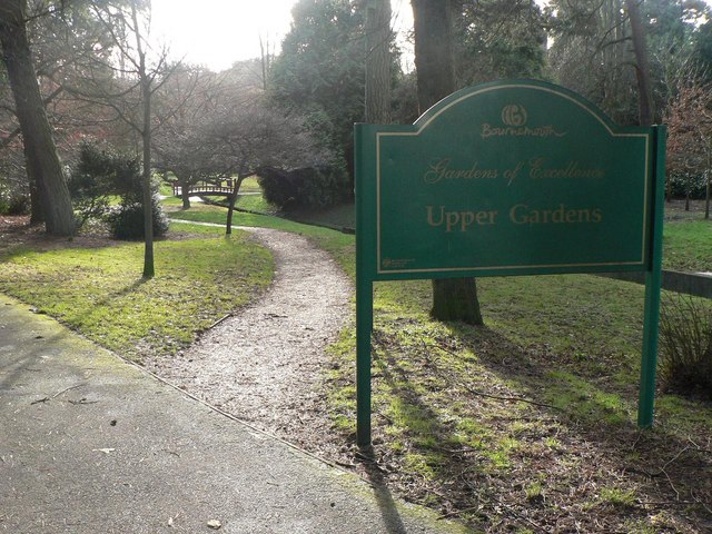
Bournemouth Gardens are Grade II listed gardens in the town of Bournemouth, Dorset, England. Created in the nineteenth century, the gardens follow the towns eponymous River Bourne three kilometres from the historic boundary with Poole south-eastwards into Bournemouth Town Centre. The Gardens are home to a number of significant Bournemouth landmarks and listed buildings such as; the Town Hall, the War Memorial, St. Andrew's Church and the Pavilion Theatre. Bournemouth Gardens have been Green Flag Award winners since 1999. History The gardens were planted between 1836 and 1840, with designs made by architects Benjamin Ferrey and Decimus Burton. It wasn't until 1859 that the gardens became publicly accessible. On 1 May 1908, 7 people were killed and 26 were injured when a tram crashed into the gardens. In 1924-29 the Pavilion Theatre was built in the Lower Central Gardens. In 1970 the Wessex Way flyover ( A338) was constructed, cutting through the Upper Central Gardens ... [...More Info...] [...Related Items...] OR: [Wikipedia] [Google] [Baidu] |
Knighton Heath
Knighton Heath is an area of Bournemouth, Dorset in England. Knighton Heath is south of Bearwood, west of Wallisdown and West Howe, and north of Alderney. Facilities Knighton Heath is home to a golf club, an industrial estate and Bournemouth Water Bournemouth Water provides drinking water to approximately 500,000 people from the port town of Poole to Beaulieu in the New Forest and from Bournemouth to Salisbury in Wiltshire, an area of over 1000 square kilometres. History Bournemouth Wat .... In May 2020, the golf course was set on fire. Politics Knighton Heath is part of the Bournemouth West parliamentary constituency. References External links Knighton Heath Industrial Estate Areas of Bournemouth Heaths of the United Kingdom {{Dorset-geo-stub ... [...More Info...] [...Related Items...] OR: [Wikipedia] [Google] [Baidu] |
Rivers Of Poole
A river is a natural flowing watercourse, usually freshwater, flowing towards an ocean, sea, lake or another river. In some cases, a river flows into the ground and becomes dry at the end of its course without reaching another body of water. Small rivers can be referred to using names such as creek, brook, rivulet, and rill. There are no official definitions for the generic term river as applied to geographic features, although in some countries or communities a stream is defined by its size. Many names for small rivers are specific to geographic location; examples are "run" in some parts of the United States, " burn" in Scotland and northeast England, and "beck" in northern England. Sometimes a river is defined as being larger than a creek, but not always: the language is vague. Rivers are part of the water cycle. Water generally collects in a river from precipitation through a drainage basin from surface runoff and other sources such as groundwater recharge, springs, ... [...More Info...] [...Related Items...] OR: [Wikipedia] [Google] [Baidu] |
Rivers Of Bournemouth
A river is a natural flowing watercourse, usually freshwater, flowing towards an ocean, sea, lake or another river. In some cases, a river flows into the ground and becomes dry at the end of its course without reaching another body of water. Small rivers can be referred to using names such as creek, brook, rivulet, and rill. There are no official definitions for the generic term river as applied to geographic features, although in some countries or communities a stream is defined by its size. Many names for small rivers are specific to geographic location; examples are "run" in some parts of the United States, "burn" in Scotland and northeast England, and "beck" in northern England. Sometimes a river is defined as being larger than a creek, but not always: the language is vague. Rivers are part of the water cycle. Water generally collects in a river from precipitation through a drainage basin from surface runoff and other sources such as groundwater recharge, spring ... [...More Info...] [...Related Items...] OR: [Wikipedia] [Google] [Baidu] |
The Square, Bournemouth
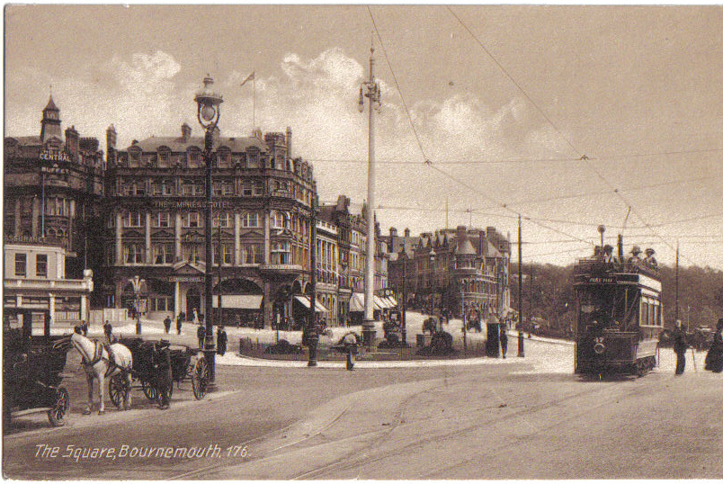
The Square is a public square in Bournemouth Town Centre that marks the centre of Bournemouth, England. The Square separates the Central Gardens from the Lower Gardens. History In the 18th century Decoy Pond House stood at the point where a plank was used to cross the Bourne Steam on the track from Poole to Christchurch. The River Bourne still flows under the Square. In 1848 composer Hubert Parry was born next door to The Square and is marked with a blue plaque. In 1925, a tram shelter was built at the center of the Square, with a clock on the top, which was given by Captain HB Norton, a magistrate and former Councillor. The Square later became a large roundabout, with the clock being relocated into a clock tower at the roundabout's centre. By this time the clock tower had become known as the "Leaning Tower of Bournemouth". The roundabout was removed in October 1992, and since 2000 the square has been almost totally pedestrianised. The old clocktower is now the site of t ... [...More Info...] [...Related Items...] OR: [Wikipedia] [Google] [Baidu] |
Bournemouth Town Centre
Bournemouth Town Centre is an area of Bournemouth, Dorset. The town centre is the central business district and is located near the coast between West Cliff and East Cliff. History In 1908 a tramway accident killed 7 people in the Town Centre. The COVID-19 pandemic in the United Kingdom has affected business in the town centre. The New Look store in the town centre will close in February 2022 after 21 years. The Wilko will close the same month. A shift from retail towards entertainment and eating out is predicted to be the future of the town centre. On 13 March 2022, the towns House of Fraser, closed for the final time. The store, which first opened in 1873, was Bournemouth's last remaining department store after the flagship Beales closed in 2020, and Debenhams closed in 2021. Despite this Bournemouth, Christchurch and Poole Council are reportedly optimistic about the future of the town centre. Areas The town centre is where The Square is. Areas include Richmon ... [...More Info...] [...Related Items...] OR: [Wikipedia] [Google] [Baidu] |
Poole Bay
Poole Bay is a bay in the English Channel, on the coast of Dorset in southern England, which stretches 16km from Sandbanks at the mouth of Poole Harbour in the west, to Hengistbury Head in the east. Poole Bay is a relatively shallow embayment and consists of steep sandstone cliffs and several 'chines' that allow easy access to the sandy beaches below. The coast along the bay is continuously built up, and is part of the South East Dorset conurbation, including parts of the towns of Poole, Bournemouth and Christchurch. The bay is also called Bournemouth Bay, because much of it is occupied by Bournemouth. In terms of sand on England's south coast the bay presents the longest stretch; much exceeded by the total to the west across numerous bays and coves but greater than the three such stretches to the east, Avon Beach, West Wittering and Camber Sands. History Measures to prevent coastal erosion have been deployed throughout the 20th century. Concrete seawalls and groynes allowed ... [...More Info...] [...Related Items...] OR: [Wikipedia] [Google] [Baidu] |
Seep (hydrology)
A seep or flush is a moist or wet place where water, usually groundwater, reaches the earth's surface from an underground aquifer. Description Seeps are usually not of sufficient volume to be flowing beyond their immediate above-ground location. They are part of the limnology-geomorphology system. Like a higher volume spring, the water is only from underground sources. Seeps mostly occur in lower elevation areas because water runs downhill, but can happen higher up if the groundwater present is abundant enough. Along with natural seeps, man made seeps can occur by digging anywhere where there is wet ground. This method can be useful for survival purposes and helps the local wildlife by adding another water source to the area. Seeps often form a puddle, and are important for small wildlife, bird, and butterfly habitat and moisture needs. When they support mud-puddling many butterfly (''Lepidoptera'') species can obtain nutrients such as salts and amino acids, including some types ... [...More Info...] [...Related Items...] OR: [Wikipedia] [Google] [Baidu] |
Bournemouth And West Hampshire Water
Bournemouth Water provides drinking water to approximately 500,000 people from the port town of Poole to Beaulieu in the New Forest and from Bournemouth to Salisbury in Wiltshire, an area of over 1000 square kilometres. History Bournemouth Water (established 1863) and West Hampshire Water (established 1893) were two former statutory water companies established by Act of Parliament. The ''Bournemouth Company'' were the alternative supplier of gas until nationalisation of the gas industry in 1949 In 1863 Bournemouth Water was established with waterworks in Bourne Valley and a reservoir in Parkstone. In 1893 The West Hampshire Water Company was established. In 1994 Bournemouth and West Hampshire Water was formed as the two companies merge. In July 2010 Bournemouth and West Hampshire Water was acquired by Sembcorp Utilities. Sembcorp Utilities is a wholly owned subsidiary of Sembcorp Industries, an energy, water and marine group listed on the main board of the Singapore Excha ... [...More Info...] [...Related Items...] OR: [Wikipedia] [Google] [Baidu] |
United Kingdom
The United Kingdom of Great Britain and Northern Ireland, commonly known as the United Kingdom (UK) or Britain, is a country in Europe, off the north-western coast of the continental mainland. It comprises England, Scotland, Wales and Northern Ireland. The United Kingdom includes the island of Great Britain, the north-eastern part of the island of Ireland, and many smaller islands within the British Isles. Northern Ireland shares a land border with the Republic of Ireland; otherwise, the United Kingdom is surrounded by the Atlantic Ocean, the North Sea, the English Channel, the Celtic Sea and the Irish Sea. The total area of the United Kingdom is , with an estimated 2020 population of more than 67 million people. The United Kingdom has evolved from a series of annexations, unions and separations of constituent countries over several hundred years. The Treaty of Union between the Kingdom of England (which included Wales, annexed in 1542) and the Kingdom of Scotland in 170 ... [...More Info...] [...Related Items...] OR: [Wikipedia] [Google] [Baidu] |
Canford Heath
Canford Heath is a suburb and area of heathland in Poole, Dorset, known for being the largest heathland in Dorset, and the largest lowland heath in the UK. It is also the name of the housing development built on the heathland in the 1960s, 1970s and 1980s. The area is split into two wards, and at the 2011 census the combined population of the two wards was 14,079. History Historically, Canford Heath was part of the Canford Estate; in the Domesday Book, the manor of ''Cheneford'' was held by Edward of Salisbury. Canford Heath was common land. In 1810, it was subdivided among Poole's Proprietors, in response to the 1805 Enclosure Act, which "enabled the enclosure of over 9000 acres of ‘Common Meadows, Heaths, Waste Lands and Commonable Grounds’". In the early 20th century, Canford Heath had many different uses. In 1929, a hillclimb event for the "Motorcycle and Light Car Club" was staged here, and during the Second World War, the heath was used as a munitions storage. In ... [...More Info...] [...Related Items...] OR: [Wikipedia] [Google] [Baidu] |
Poole
Poole () is a large coastal town and seaport in Dorset, on the south coast of England. The town is east of Dorchester and adjoins Bournemouth to the east. Since 1 April 2019, the local authority is Bournemouth, Christchurch and Poole Council which is a unitary authority. Poole had an estimated population of 151,500 (mid-2016 census estimates) making it the second-largest town in the ceremonial county of Dorset. Together with Bournemouth and Christchurch, the conurbation has a total population of nearly 400,000. Human settlement in the area dates back to before the Iron Age. The earliest recorded use of the town's name was in the 12th century when the town began to emerge as an important port, prospering with the introduction of the wool trade. Later, the town had important trade links with North America and, at its peak during the 18th century, it was one of the busiest ports in Britain. In the Second World War, Poole was one of the main departing points for the Normandy l ... [...More Info...] [...Related Items...] OR: [Wikipedia] [Google] [Baidu] |


