|
River Ant
The River Ant is a tributary river of the River Bure in the county of Norfolk, England. It is long (of which 8.75 miles are now navigable), and has an overall drop of 27 metres from source to mouth. It is said that the Ant was formerly known as the River Smale and that this is the origin of the name of the village of Smallburgh. The Ant Broads & Marshes NNR is a national nature reserve. From source to Honing The river's source is just east of the village of Antingham in North Norfolk at Antingham Ponds. Just below the pools the river's route has been used as a canal in the past, starting at what was Antingham bone mill. An Act of Parliament established the North Walsham & Dilham Canal in 1812, as a wide gauge canal able to take a Norfolk wherry. It was built at a cost of £30,000 and opened on 25 July 1826, making the river navigable as far as Dilham, where the river widens and deepens. It carried manure, offal, flour, coal, and farm produce. In 1885, the canal was sold for  ... [...More Info...] [...Related Items...] OR: [Wikipedia] [Google] [Baidu] |
England
England is a country that is part of the United Kingdom. It shares land borders with Wales to its west and Scotland to its north. The Irish Sea lies northwest and the Celtic Sea to the southwest. It is separated from continental Europe by the North Sea to the east and the English Channel to the south. The country covers five-eighths of the island of Great Britain, which lies in the North Atlantic, and includes over 100 smaller islands, such as the Isles of Scilly and the Isle of Wight. The area now called England was first inhabited by modern humans during the Upper Paleolithic period, but takes its name from the Angles, a Germanic tribe deriving its name from the Anglia peninsula, who settled during the 5th and 6th centuries. England became a unified state in the 10th century and has had a significant cultural and legal impact on the wider world since the Age of Discovery, which began during the 15th century. The English language, the Anglican Church, and Engli ... [...More Info...] [...Related Items...] OR: [Wikipedia] [Google] [Baidu] |
Honing, Norfolk
Honing is a village and a civil parish in the English county of Norfolk. The village is north-northeast of Norwich, south east of Cromer and north-east of London. The village lies east of the town of North Walsham. The nearest railway station is at Worstead on the Bittern Line which runs between Cromer and Norwich. The nearest airport is Norwich International Airport. The village and parish of Honing with Crostwight had in the 2001 census, a population of 319, but this fell to 312 at the 2011 Census. For the purposes of local government, the village falls within the district of North Norfolk. Description Honing is a large parish in north-east of the county of Norfolk. Its northern boundary is with the civil parish of Witton whilst to the south is the parish of Dilham. West lies Worstead and on the eastern boundary is the parish of East Ruston. The disused North Walsham & Dilham Canal runs along the south-west boundary of the parish. There are several areas of common land ... [...More Info...] [...Related Items...] OR: [Wikipedia] [Google] [Baidu] |
Barton Turf
Barton Turf is a village and civil parish in the English county of Norfolk. It is 20 km north-east of the city of Norwich, on the northwestern edge of Barton Broad, the second largest of the Norfolk Broads. In primary local government the area is in the district of North Norfolk. The villages name means 'Barley farm/settlement'. 'Turf' is a late 14th century addition, probably indicating that turf cutting was an important local industry. The civil parish, which includes the whole of Barton Broad and the smaller village of Irstead at its southern end, has an area of 10.86 km2. In the 2001 census it had a population of 480 in 181 households, the population decreasing to 467 at the 2011 Census. Barton Turf's St Michael and All Angels Church, Barton Turf, about a mile from the clustered village centre, has a large, ornate medieval painted rood screen such as many medieval parishes who could afford fine artisans once had, but which have rarely survived the English Ref ... [...More Info...] [...Related Items...] OR: [Wikipedia] [Google] [Baidu] |
Barton Broad
Barton Broad is a nature reserve north-east of Norwich in Norfolk. It is owned and managed by the Norfolk Wildlife Trust. It is part of the Ant Broads and Marshes Site of Special Scientific Interest and National Nature Reserve, and part of it is in the Ant Marshes Nature Conservation Review site, Grade I. It is part of the Broadland Ramsar site and Special Protection Area, and The Broads Special Area of Conservation. The Broad was created in the Middle Ages by digging for peat and the River Ant The River Ant is a tributary river of the River Bure in the county of Norfolk, England. It is long (of which 8.75 miles are now navigable), and has an overall drop of 27 metres from source to mouth. It is said that the Ant was formerly known as ... was later diverted through it, which allowed navigation. It has diverse aquatic plants and fish, and the surrounding fens have nationally rare plants and invertebrates. There is public access to the reserve. References {{Authority ... [...More Info...] [...Related Items...] OR: [Wikipedia] [Google] [Baidu] |
Phragmites
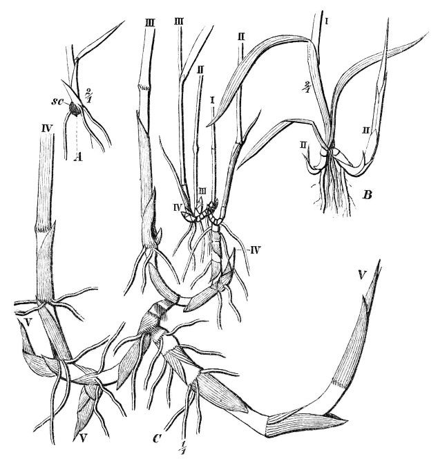
''Phragmites'' () is a genus of four species of large perennial reed grasses found in wetlands throughout temperate and tropical regions of the world. Taxonomy The World Checklist of Selected Plant Families, maintained by Kew Garden in London, accepts the following four species: * ''Phragmites australis'' ( Cav.) Trin. ex Steud. – cosmopolitan * ''Phragmites japonicus'' Steud. – Japan, Korea, Ryukyu Islands, Russian Far East * ''Phragmites karka'' ( Retz.) Trin. ex Steud. – tropical Africa, southern Asia, Australia, some Pacific Islands, invasive in New Zealand * ''Phragmites mauritianus'' Kunth – central + southern Africa, Madagascar, Mauritius The cosmopolitan common reed has the generally accepted botanical name ''Phragmites australis''. (Cav.) Trin. ex Steud. About 130 other synonyms have been proposed. Examples include ''Phragmites communis'' Trin., ''Arundo phragmites'' L., and ''Phragmites vulgaris'' (Lam.) Crép. (illegitimate name). Wildlife in reed beds ... [...More Info...] [...Related Items...] OR: [Wikipedia] [Google] [Baidu] |
Marshes
A marsh is a wetland that is dominated by herbaceous rather than woody plant species.Keddy, P.A. 2010. Wetland Ecology: Principles and Conservation (2nd edition). Cambridge University Press, Cambridge, UK. 497 p Marshes can often be found at the edges of lakes and streams, where they form a transition between the aquatic and terrestrial ecosystems. They are often dominated by grasses, rushes or reeds. If woody plants are present they tend to be low-growing shrubs, and the marsh is sometimes called a carr. This form of vegetation is what differentiates marshes from other types of wetland such as swamps, which are dominated by trees, and mires, which are wetlands that have accumulated deposits of acidic peat. Marshes provide habitats for many kinds of invertebrates, fish, amphibians, waterfowl and aquatic mammals. This biological productivity means that marshes contain 0.1% of global sequestered terrestrial carbon. Moreover, they have an outsized influence on climate resil ... [...More Info...] [...Related Items...] OR: [Wikipedia] [Google] [Baidu] |
Hunsett Windmill
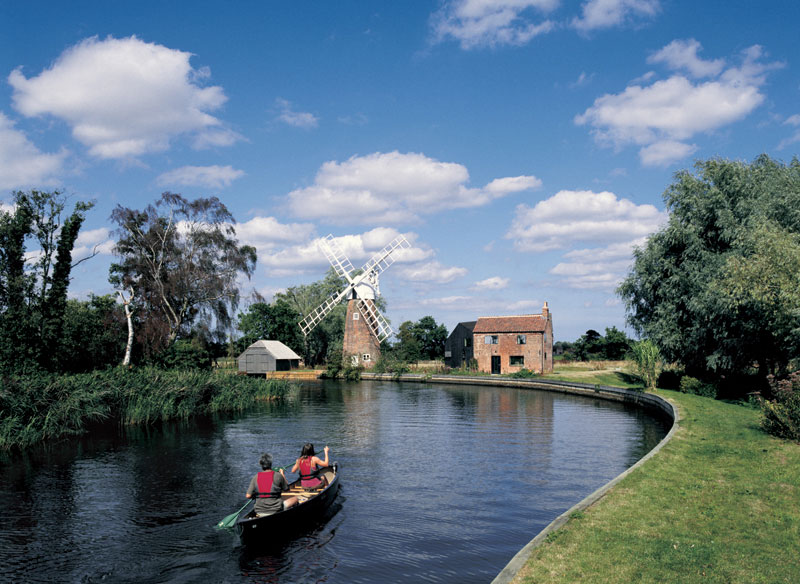
Hunsett Mill is located on the east bank of the River Ant one mile north of Barton Broad in the English county of Norfolk. The Windmill is 1.2 miles south west of the town of Stalham. The mill structure is a grade II listed building. Description The Windmill was built in 1860 and is constructed of red bricks. The mill has a White boat shaped cap sails and a fantail. The windpump once ran two scoop wheels. The tower had four patent sails. The mill is approximately 12 m high, and has been visually retained in its original historic condition, even though internal works to the mill in the 1960s have removed all mill equipment previously installed in the brick structure. The mill is part of the large historic pumping mill system characteristic to the Broads, and is Grade II listed. ( List of drainage windmills in Norfolk) The house adjacent to the mill has originally been built around the same time as the mill, but to less good standards than the mill itself. The house was built on a ... [...More Info...] [...Related Items...] OR: [Wikipedia] [Google] [Baidu] |
R A Lister And Company
R A Lister & Company was founded in Dursley, Gloucestershire, England, in 1867 by Sir Robert Ashton Lister (1845–1929), to produce agricultural machinery. History 1867–1906: Foundation and growth The founder of R A Lister and Company was Robert Ashton Lister, who was born in 1845. He led the exhibit of the family's products to the Paris Exhibition of 1867, but on return fell out with his father, and in the same year founded R.A.Lister and Company in the former Howard's Lower Mill, Water Street in Dursley to manufacture agricultural machinery. In 1889 Robert acquired the UK rights to manufacture and sell Danish engineer Mikael Pedersen's new cream separator, which through a spinning centrifugal separator allowed the machine to run at a constant speed and hence create a regular consistency of cream. Marketed in the UK and British Empire as "The Alexandra Cream Separator", its success resulted in Pedersen moving to Dursley. In 1899, he founded the Dursley Pedersen Cycle ... [...More Info...] [...Related Items...] OR: [Wikipedia] [Google] [Baidu] |
Water Newton
Water Newton is a village and civil parish in Cambridgeshire, England. Water Newton lies approximately west of Peterborough. Water Newton is situated within Huntingdonshire which is a non-metropolitan district of Cambridgeshire as well as being a historic county of England. As the population of the village was 88 only at the 2011 Census it is included in the civil parish of Chesterton. The village is sandwiched between the River Nene to the north and the A1 trunk road to the south. The River Nene marks the boundary between Huntingdonshire and the City of Peterborough. History Roman archaeology :''Main articles: Durobrivae and Water Newton Treasure'' During ploughing in February 1975, a hoard of 4th-century Roman silver was discovered, which is known as the 'Water Newton Treasure'. They were probably buried by an inhabitant of the nearby Roman fortified garrison town of '' Durobrivae''. The silver plates and bowls, votive tokens engraved and embossed with the labarum (the c ... [...More Info...] [...Related Items...] OR: [Wikipedia] [Google] [Baidu] |
Wayford Bridge
Wayford Bridge is a village on the River Ant on the A149 road, near Stalham in Norfolk, England within The Broads National Park. Due to height restrictions under the road bridge it is the most northerly point of navigation on the Norfolk Broads for boats over in height above the water line. Broads boats can continue to Dilham Dilham is a village and civil parish in the English county of Norfolk. The village is located 4.3 miles south-east of North Walsham and 12 miles north-east of Norwich, and is situated on the River Ant. History Dilham's name is of Anglo-Saxon ..., though the channel is narrow and has limited places in which to turn around. External links Villages in Norfolk North Norfolk {{Norfolk-geo-stub ... [...More Info...] [...Related Items...] OR: [Wikipedia] [Google] [Baidu] |


