|
Rhosyr (cantref)
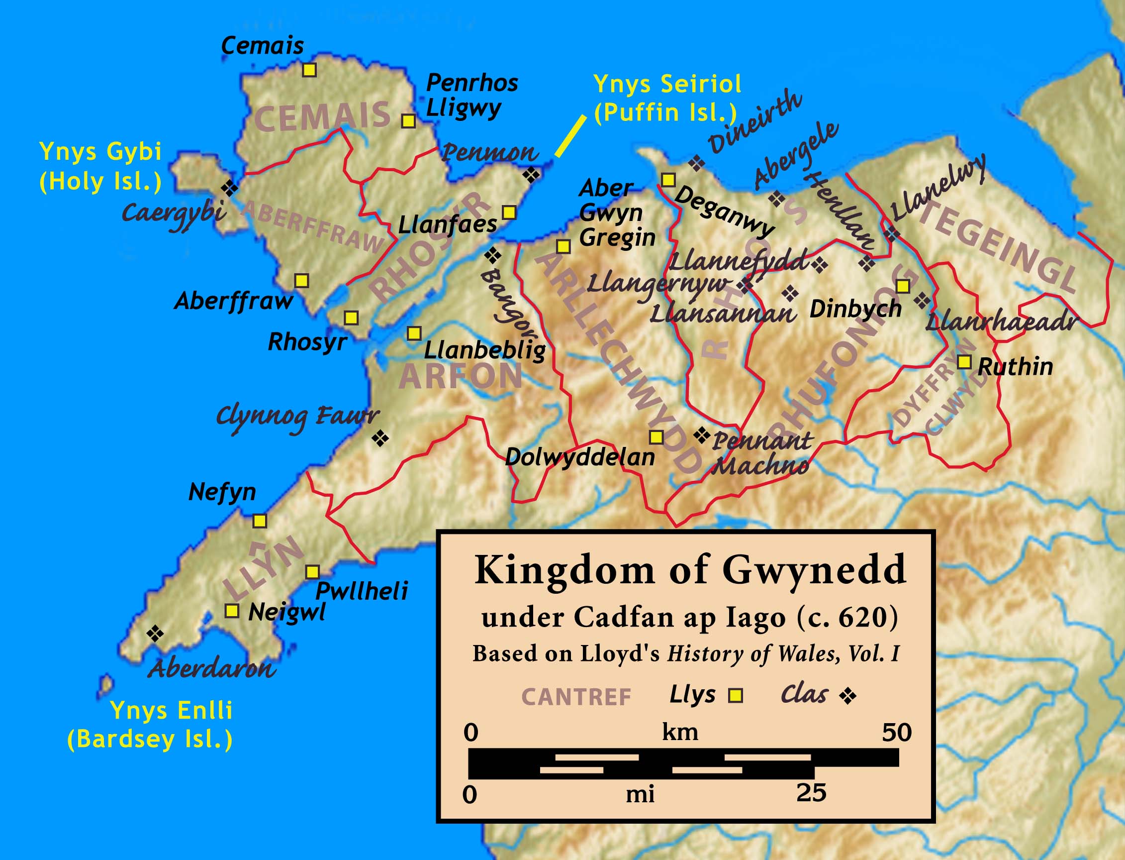
Rhosyr was the name of one of the three medieval cantrefs (meaning ''a hundred towns'') on the island of Anglesey, north Wales, in the Kingdom of Gwynedd. It lay on the southern side of the island facing the Menai Strait which separates Anglesey from the mainland. There are indications that Rhosyr existed as far back as the 6th century and the period of St Caffo and King Maelgwn Gwynedd. The cantref stretched inland from the Menai Strait to the tidal Maltreath estuary, controlling the dry land route through Anglesey, hence held a strategic position.Rhosyr: Its History and Topography in the Age of the Welsh Princes, pp. 8-10 The township of Rhosyr, in the south of the cantref, was of military importance for controlling access to the Menai Strait. ''Rhosyr: Its History and Topography in the Age of the Welsh Princes'', pp. 13-14 See also * Aberffraw cantref * Cemais (Anglesey cantref) Cemais was one of the three medieval cantrefs on the island of Anglesey, north Wales, in the K ... [...More Info...] [...Related Items...] OR: [Wikipedia] [Google] [Baidu] |
Gwynedd
Gwynedd (; ) is a county and preserved county (latter with differing boundaries; includes the Isle of Anglesey) in the north-west of Wales. It shares borders with Powys, Conwy County Borough, Denbighshire, Anglesey over the Menai Strait, and Ceredigion over the River Dyfi. The scenic Llŷn Peninsula and most of Snowdonia National Park are in Gwynedd. Bangor is the home of Bangor University. As a local government area, it is the second largest in Wales in terms of land area and also one of the most sparsely populated. A majority of the population is Welsh-speaking. ''Gwynedd'' also refers to being one of the preserved counties of Wales, covering the two local government areas of Gwynedd and Anglesey. Named after the old Kingdom of Gwynedd, both culturally and historically, ''Gwynedd'' can also be used for most of North Wales, such as the area that was policed by the Gwynedd Constabulary. The current area is , with a population of 121,874 as measured in the 2011 Census. Et ... [...More Info...] [...Related Items...] OR: [Wikipedia] [Google] [Baidu] |
Cantref
A cantref ( ; ; plural cantrefi or cantrefs; also rendered as ''cantred'') was a medieval Welsh land division, particularly important in the administration of Welsh law. Description Land in medieval Wales was divided into ''cantrefi'', which were themselves divided into smaller ''cymydau'' (commotes). The word ''cantref'' is derived from ''cant'' ("a hundred") and ''tref'' ("town" in modern Welsh, but formerly used for much smaller settlements). The ''cantref'' is thought to be the original unit, with the commotes being a later division. ''Cantrefi'' could vary considerably in size: most were divided into two or three commotes, but the largest, the ''Cantref Mawr'' (or "Great Cantref") in Ystrad Tywi (now in Carmarthenshire) was divided into seven commotes. History The antiquity of the ''cantrefi'' is demonstrated by the fact that they often mark the boundary between dialects. Some were originally kingdoms in their own right; others may have been artificial units created later. ... [...More Info...] [...Related Items...] OR: [Wikipedia] [Google] [Baidu] |
Anglesey
Anglesey (; cy, (Ynys) Môn ) is an island off the north-west coast of Wales. It forms a principal area known as the Isle of Anglesey, that includes Holy Island across the narrow Cymyran Strait and some islets and skerries. Anglesey island, at , is the largest in Wales, the seventh largest in Britain, largest in the Irish Sea and second most populous there after the Isle of Man. Isle of Anglesey County Council administers , with a 2011 census population of 69,751, including 13,659 on Holy Island. The Menai Strait to the mainland is spanned by the Menai Suspension Bridge, designed by Thomas Telford in 1826, and the Britannia Bridge, built in 1850 and replaced in 1980. The largest town is Holyhead on Holy Island, whose ferry service with Ireland handles over two million passengers a year. The next largest is Llangefni, the county council seat. From 1974 to 1996 Anglesey was part of Gwynedd. Most full-time residents are habitual Welsh speakers. The Welsh name Ynys M ... [...More Info...] [...Related Items...] OR: [Wikipedia] [Google] [Baidu] |
Kingdom Of Gwynedd
The Kingdom of Gwynedd (Medieval Latin: ; Middle Welsh: ) was a Welsh kingdom and a Roman Empire successor state that emerged in sub-Roman Britain in the 5th century during the Anglo-Saxon settlement of Britain. Based in northwest Wales, the rulers of Gwynedd repeatedly rose to dominance and were acclaimed as " King of the Britons" before losing their power in civil wars or invasions. The kingdom of Gruffydd ap Llywelynthe King of Wales from 1055 to 1063was shattered by a Saxon invasion in 1063 just prior to the Norman invasion of Wales, but the House of Aberffraw restored by Gruffudd ap Cynan slowly recovered and Llywelyn the Great of Gwynedd was able to proclaim the Principality of Wales at the Aberdyfi gathering of Welsh princes in 1216. In 1277, the Treaty of Aberconwy between Edward I of England and Llewelyn's grandson Llywelyn ap Gruffudd granted peace between the two but would also guarantee that Welsh self-rule would end upon Llewelyn's death, and so it represented ... [...More Info...] [...Related Items...] OR: [Wikipedia] [Google] [Baidu] |
Menai Strait
The Menai Strait ( cy, Afon Menai, the "river Menai") is a narrow stretch of shallow tidal water about long, which separates the island of Anglesey from the mainland of Wales. It varies in width from from Fort Belan to Abermenai Point to from Traeth Gwyllt to Caernarfon Castle. It then narrows to in the middle reaches (Y Felinheli and Menai Bridge) and then it broadens again. At Bangor, Garth Pier, it is wide. It then widens out, and the distance from Puffin Island (Welsh: ''Ynys Seiriol'') to Penmaenmawr is about . The differential tides at the two ends of the strait cause very strong currents to flow in both directions through the strait at different times, creating dangerous conditions. One of the most dangerous areas of the strait is known as the Swellies (or Swillies – Welsh ''Pwll Ceris'') between the two bridges. Here, rocks near the surface cause over-falls and local whirlpools, which can be of considerable danger in themselves and cause small boats to founde ... [...More Info...] [...Related Items...] OR: [Wikipedia] [Google] [Baidu] |
St Caffo
Caffo was a sixth-century Christian in Anglesey, north Wales, who is venerated as a saint and martyr. The son of a king from northern Britain who took shelter in Anglesey, Caffo was a companion of St Cybi, and is mentioned as carrying a red-hot coal in his clothes to Cybi without his clothes getting burnt. After leaving Cybi, Caffo was killed by shepherds in the south of Anglesey, possibly acting in retaliation for insults Caffo's brother had paid to the local ruler. The area where he died has a village, Llangaffo, named after him, as well as the parish church of St Caffo, Llangaffo. Life and martyrdom Little is known for certain about Caffo; his dates of birth and death are not given in the sources. He is said to have been one of the sons of St Caw, a king in northern Britain who lost his lands and sought safety with his family in Anglesey; the ruler Maelgwn Gwynedd gave him land in the north-east of the island, in the district known as Twrcelyn. Other relatives of Caffo in ... [...More Info...] [...Related Items...] OR: [Wikipedia] [Google] [Baidu] |
Maelgwn Gwynedd
Maelgwn Gwynedd ( la, Maglocunus; died c. 547Based on Phillimore's (1888) reconstruction of the dating of the ''Annales Cambriae'' (A Text).) was king of Gwynedd during the early 6th century. Surviving records suggest he held a pre-eminent position among the Brythonic kings in Wales and their allies in the " Old North" along the Scottish coast. Maelgwn was a generous supporter of Christianity, funding the foundation of churches throughout Wales and even far beyond the bounds of his own kingdom. Nonetheless, his principal legacy today is the scathing account of his behavior recorded in ''De Excidio et Conquestu Britanniae'' by Gildas, who considered Maelgwn a usurper and reprobate. The son of Cadwallon Lawhir and great-grandson of Cunedda, Maelgwn was buried on '' Ynys Seiriol'' (now known as Puffin Island in English), off the eastern tip of Anglesey, having died of the "yellow plague"; quite probably the arrival of Justinian's Plague in Britain. Name ''Maelgwn'' (IPA: /mɑːɨlg� ... [...More Info...] [...Related Items...] OR: [Wikipedia] [Google] [Baidu] |
Malltraeth Marsh
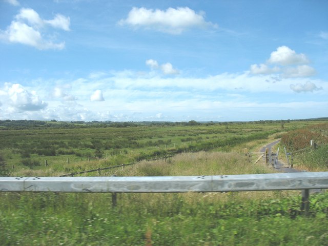
Malltraeth Marsh (also spelled as Malldraeth; cy, Cors Malltraeth or cy, Cors Ddyga, label=none) is a large marsh area in Anglesey, North Wales, north-east of Malltraeth village, along the flatlands of Trefdraeth, Bodorgan, Llangristiolus and south of Cefn Cwmwd, Rhostrehwfa. It was reclaimed from estuarine marshes after the construction of the Malltraeth Cob (dyke), a long embankment, and the subsequent canalisation in 1824 of the Afon Cefni. The name Malltraeth comes from ''mall'' ('bad'), and ''traeth'' ('sandy shore'). The marsh measures in area. The area is recognised as a Site of Special Scientific Interest (SSSI), and has a range of reedbeds, marshes, wet grassland and small pools/lakes. History In the Middle Ages the Malltraeth estuary was tidal, stretching as far inland as Llangefni and Ceint. In 1790, an act of Parliament was obtained for more effectually embanking the marshes called Malltraeth and Corsddeuga, under the provisions of which were allotted to ... [...More Info...] [...Related Items...] OR: [Wikipedia] [Google] [Baidu] |
Aberffraw Cantref
Aberffraw was one of the three medieval cantrefs on the island of Anglesey, north Wales, in the Kingdom of Gwynedd. It lay on the western side of the island on Caernarfon Bay. Its administrative centre was Aberffraw, ancient seat of the Princes of Gwynedd. The cantref consisted of the two cwmwds of Llifon and Malltraeth. See also * Cemais (Anglesey cantref) Cemais was one of the three medieval cantrefs on the island of Anglesey, north Wales, in the Kingdom of Gwynedd. It lay on the northern side of the island on the Irish Sea. The cantref consisted of the two cwmwds of Talybolion and Twrcelyn. Se ... * Rhosyr (cantref) Cantrefs History of Anglesey {{Anglesey-geo-stub ... [...More Info...] [...Related Items...] OR: [Wikipedia] [Google] [Baidu] |
Cemais (Anglesey Cantref)
Cemais was one of the three medieval cantrefs on the island of Anglesey, north Wales, in the Kingdom of Gwynedd. It lay on the northern side of the island on the Irish Sea. The cantref consisted of the two cwmwds of Talybolion and Twrcelyn. See also * Aberffraw cantref Aberffraw was one of the three medieval cantrefs on the island of Anglesey, north Wales, in the Kingdom of Gwynedd. It lay on the western side of the island on Caernarfon Bay. Its administrative centre was Aberffraw, ancient seat of the Princes ... * Rhosyr (cantref) Cantrefs History of Anglesey {{Anglesey-geo-stub ... [...More Info...] [...Related Items...] OR: [Wikipedia] [Google] [Baidu] |


