|
Rhosgoch
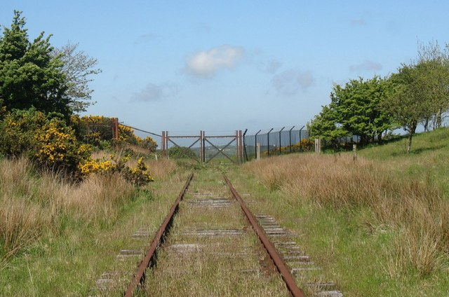
Rhosgoch (; meaning: ''Red Moor'') is a small village in the north of the island of Anglesey, Wales, about to the south-west of Amlwch. It is in the community of Rhosybol. A short distance to the west of the village is the small lake Llyn Hafodol and a mile to the south is Anglesey's largest body of water the reservoir Llyn Alaw (''Water Lily Lake''). The village once had a station on the Anglesey Central Railway. Although the tracks still exist, no train has run on them since 1993. Also connected to the railway, was a short south-west facing spur that led to an oil terminal. This was linked to a floating dock in the sea off of Amlwch, where super-tankers could dock in all tides and feed oil via Rhosgoch and a pipeline to Stanlow oil refinery. This operation lasted for 16 years between 1974 and 1990. The first tornado of the record-breaking 1981 United Kingdom tornado outbreak The 1981 United Kingdom tornado outbreak is regarded as the largest recorded tornado outbreak i ... [...More Info...] [...Related Items...] OR: [Wikipedia] [Google] [Baidu] |
Anglesey Central Railway
The Anglesey Central Railway (Welsh: ''Lein Amlwch'', ''Amlwch Line'') was a standard-gauge railway in Anglesey, Wales, connecting the port of Amlwch and the county town of Llangefni with the North Wales Coast Line at Gaerwen. Built as an independent railway, the railway opened in portions from 1864 to 1867. Due to financial troubles the railway was sold to the London and North Western Railway in 1876, which invested significantly in the infrastructure. Operation continued under various companies during the 20th century, but passenger services were withdrawn in 1964 as part of the Beeching Axe. Industrial freight services continued until 1993. The railway's tracks remain and local groups have demonstrated an interest in restoring services as a heritage railway. The sustainable transport charity Sustrans has proposed to use the route as a cycle path (rail trail). The Welsh Assembly Government, in partnership with Network Rail, commissioned a feasibility study into the reopenin ... [...More Info...] [...Related Items...] OR: [Wikipedia] [Google] [Baidu] |
Rhosybol
Rhosybol (meaning: ''Moor in the Hollow'') is a village and community in Anglesey, Wales. The community population at the 2011 census was 1,078. Located south of the town of Amlwch, the village is close to both Llyn Alaw, the largest body of water on the island, and Parys Mountain, the site of the historic copper mines which lies just to the north. It is to the mines that the village owes its existence as it was one of several built to house the miners. During the 1960s noted painter Kyffin Williams produced an oil painting of the village. Rhosybol lies on the B5111 road from Amlwch to Llannerch-y-medd. Just to the east of the village is the Trysglwyn Wind Farm. This site covers an area of about and is operated by RWE Innogy International. Much of the land is pasture where livestock can graze to the foot of the turbines. A pond has been provided and patches of woodland have been planted to enhance the wildlife value of the site. An information board is situated at the site en ... [...More Info...] [...Related Items...] OR: [Wikipedia] [Google] [Baidu] |
Stanlow Oil Refinery
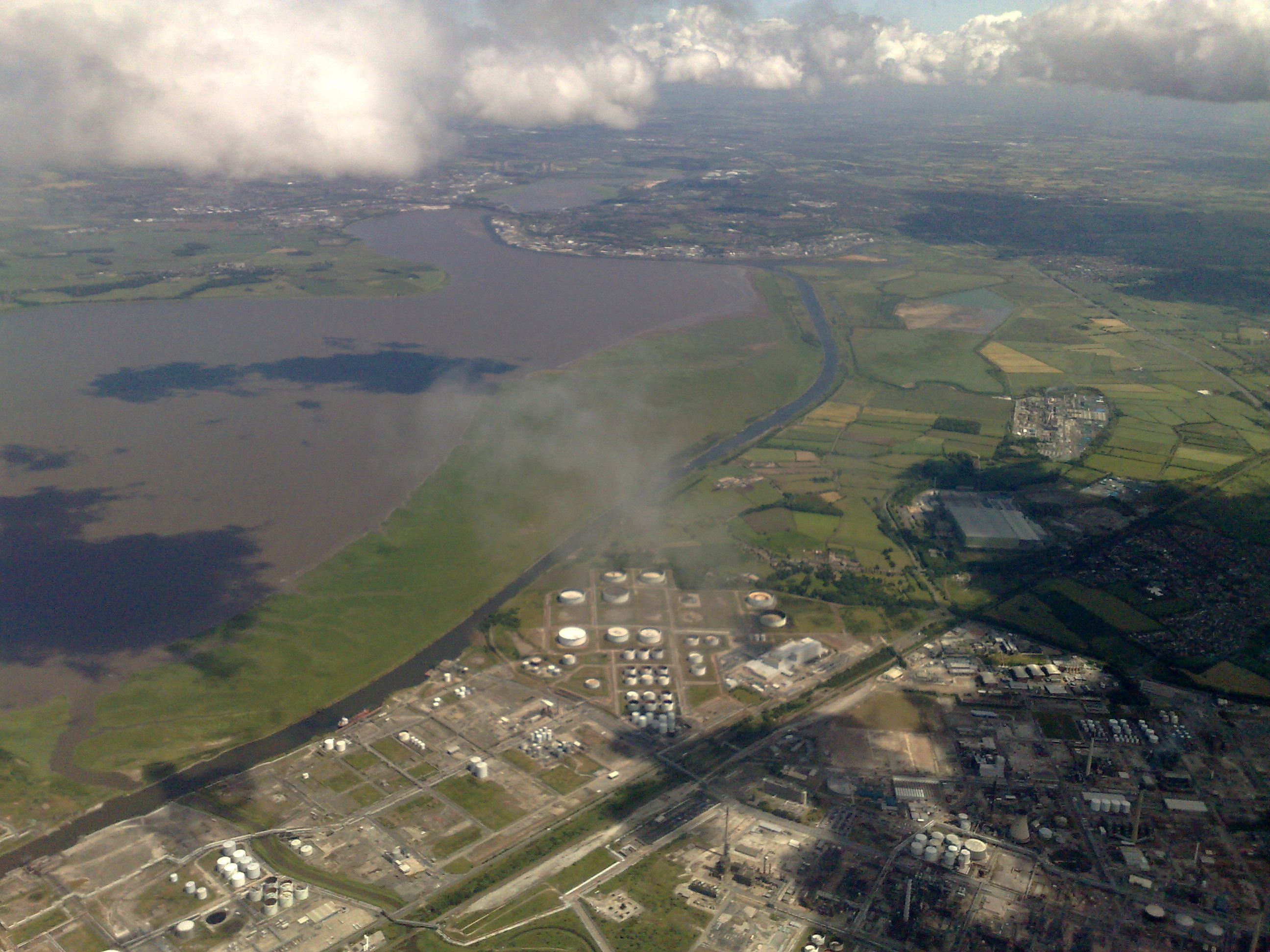
Stanlow Refinery is an oil refinery owned by Essar Energy in Ellesmere Port, North West England. Until 2011 it was owned by Shell UK. The refinery is situated on the south bank of the Manchester Ship Canal, which is used to transport seaborne oil for refining and chemicals for Essar and Shell. Stanlow has a refining capacity of 12 million tonnes per year with a barrel per day capacity of 296,000. Consequently, it is the second largest in the United Kingdom after Fawley Refinery, and produces a sixth of the UK's petrol needs. Stanlow is also a large producer for commodities such as jet fuel and diesel. Although situated in North West England, the refinery serves much of England as it is linked to the UK oil pipeline network. Oil is delivered to the Tranmere Oil Terminal via ship, then pumped to Stanlow for refining and stored for delivery. History The refinery occupies nearly near the River Mersey and dates back to 1924, when a small bitumen plant was established. Stanlow ... [...More Info...] [...Related Items...] OR: [Wikipedia] [Google] [Baidu] |
1981 United Kingdom Tornado Outbreak
The 1981 United Kingdom tornado outbreak is regarded as the largest recorded tornado outbreak in European history. In the span of 5 hours and 26 minutes during the late morning and early afternoon of 23 November 1981, 104 confirmed tornadoes touched down across Wales and central, northern and eastern England. Although the majority of tornadoes were very weak, measuring FU-F1 on the Fujita scale, widespread property damage was reported, mainly from the small number of tornadoes which intensified to F2 strength. By the end of the outbreak, hundreds of properties across the country had been damaged. Most of the tornadoes occurred in rural areas and small villages across central parts of the United Kingdom, although several large metropolitan areas were affected. The Liverpool area was the first to be struck by multiple tornadoes around 11:30, followed by the Manchester area around 12:00, the Hull area around 13:30 and the Birmingham area around 14:00. The strongest tornado of the o ... [...More Info...] [...Related Items...] OR: [Wikipedia] [Google] [Baidu] |
Entrance Gate On The Railway Spur At The Former Rhosgoch Oil Terminal - Geograph
Entrance generally refers to the place of entering like a gate, door, or road or the permission to do so. Entrance may also refer to: * ''Entrance'' (album), a 1970 album by Edgar Winter * Entrance (display manager), a login manager for the X window manager * Entrance (liturgical), a kind of liturgical procession in the Eastern Orthodox tradition * Entrance (musician), born Guy Blakeslee * ''Entrance'' (film), a 2011 film * The Entrance, New South Wales, a suburb in Central Coast, New South Wales, Australia * "Entrance" (Dimmu Borgir song), from the 1997 album '' Enthrone Darkness Triumphant'' * Entry (cards), a card that wins a trick to which another player made the lead, as in the card game contract bridge * N-Trance, a British electronic music group formed in 1990 * University and college admissions * Entrance Hall * Entryway See also *Enter (other) *Entry (other) Entry may refer to: *Entry, West Virginia, an unincorporated community in the United S ... [...More Info...] [...Related Items...] OR: [Wikipedia] [Google] [Baidu] |
Anglesey
Anglesey (; cy, (Ynys) Môn ) is an island off the north-west coast of Wales. It forms a principal area known as the Isle of Anglesey, that includes Holy Island across the narrow Cymyran Strait and some islets and skerries. Anglesey island, at , is the largest in Wales, the seventh largest in Britain, largest in the Irish Sea and second most populous there after the Isle of Man. Isle of Anglesey County Council administers , with a 2011 census population of 69,751, including 13,659 on Holy Island. The Menai Strait to the mainland is spanned by the Menai Suspension Bridge, designed by Thomas Telford in 1826, and the Britannia Bridge, built in 1850 and replaced in 1980. The largest town is Holyhead on Holy Island, whose ferry service with Ireland handles over two million passengers a year. The next largest is Llangefni, the county council seat. From 1974 to 1996 Anglesey was part of Gwynedd. Most full-time residents are habitual Welsh speakers. The Welsh name Ynys M ... [...More Info...] [...Related Items...] OR: [Wikipedia] [Google] [Baidu] |
Amlwch
Amlwch (; ) is a port town and community in Wales. It is situated on the north coast of the Isle of Anglesey, on the A5025 which connects it to Holyhead and to Menai Bridge. As well as Amlwch town and Amlwch Port, other settlements within the community include Burwen, Porthllethog/Bull Bay and Pentrefelin. The town has a beach in Llaneilian, and it has significant coastal cliffs. Tourism is an important element of the local economy. At one time it was a booming mining town that became the centre of a vast global trade in copper ore. The harbour inlet became a busy port and significant shipbuilding and ship repair centre, as well as an embarkation point with boats sailing to the Isle of Man and to Liverpool. The community covers an area of about 18 square kilometres. Town Centre The name Amlwch – a reference to the site of the town's harbour, Porth Amlwch – derives from Welsh ''am'' ("about, on or around") and ''llwch'' (an old word meaning "inlet, creek" - similar to the Ga ... [...More Info...] [...Related Items...] OR: [Wikipedia] [Google] [Baidu] |
Reservoir
A reservoir (; from French ''réservoir'' ) is an enlarged lake behind a dam. Such a dam may be either artificial, built to store fresh water or it may be a natural formation. Reservoirs can be created in a number of ways, including controlling a watercourse that drains an existing body of water, interrupting a watercourse to form an embayment within it, through excavation, or building any number of retaining walls or levees. In other contexts, "reservoirs" may refer to storage spaces for various fluids; they may hold liquids or gasses, including hydrocarbons. ''Tank reservoirs'' store these in ground-level, elevated, or buried tanks. Tank reservoirs for water are also called cisterns. Most underground reservoirs are used to store liquids, principally either water or petroleum. Types Dammed valleys Dammed reservoirs are artificial lakes created and controlled by a dam A dam is a barrier that stops or restricts the flow of surface water or underground streams ... [...More Info...] [...Related Items...] OR: [Wikipedia] [Google] [Baidu] |
Llyn Alaw
Llyn Alaw (meaning: ''Lily Lake'') is a man-made reservoir on Anglesey, North Wales managed by Dŵr Cymru Welsh Water. It is a shallow lake and was built in 1966. It is a Site of Special Scientific Interest and a destination for over-wintering birds. History It is used to supply drinking water to the northern half of the island and does so at a rate of 35 million litres a day. Filling began in November 1965, flooding the existing marsh of Cors y Bol, and was completed in January 1966. It was officially opened on 21 October 1966. Due to the area being marshland no houses or farms, let alone hamlets or villages had to be abandoned to create it. The catchment is largely agricultural, and few notable rivers feed into the lake. The storage capacity is mostly generated through trapping winter rainfall and drawing down the level in the summer months. The reservoir itself is 4.3 kilometres long with a surface area of 3.6 km2 making it the largest body of water on the island, but ... [...More Info...] [...Related Items...] OR: [Wikipedia] [Google] [Baidu] |
Villages In Anglesey
A village is a clustered human settlement or community, larger than a hamlet but smaller than a town (although the word is often used to describe both hamlets and smaller towns), with a population typically ranging from a few hundred to a few thousand. Though villages are often located in rural areas, the term urban village is also applied to certain urban neighborhoods. Villages are normally permanent, with fixed dwellings; however, transient villages can occur. Further, the dwellings of a village are fairly close to one another, not scattered broadly over the landscape, as a dispersed settlement. In the past, villages were a usual form of community for societies that practice subsistence agriculture, and also for some non-agricultural societies. In Great Britain, a hamlet earned the right to be called a village when it built a church. [...More Info...] [...Related Items...] OR: [Wikipedia] [Google] [Baidu] |


