|
Regional Geology
Regional geology is the geological study of large-scale regions. Usually, it encompasses multiple geological disciplines to piece together the history of an area. It is the geologic equivalent of regional geography. The size and the borders of each region are defined by geologically significant boundaries and by the occurrence of geologic processes. Examples of geologically significant boundaries are the interfingering facies change in sedimentary deposits when discussing a sedimentary basin system, or the leading or boundary thrust of an orogen. Africa * Geology of Africa ** Geology of Chad ** Geology of Egypt ** Geology of Madagascar ** Geology of Rwanda ** Geology of Togo Antarctica * Geology of Antarctica Asia * Geology of Asia ** Geology of Armenia ** Geology of Azerbaijan ** Geology of Bangladesh ** Geology of China ***Geology of Fujian ** Geology of Georgia (country) ** Geology of Hong Kong ** Geology of India *** Geology of Sikkim ** Geology of Indonesia ** Geology ... [...More Info...] [...Related Items...] OR: [Wikipedia] [Google] [Baidu] |
Geological
Geology () is a branch of natural science concerned with Earth and other astronomical objects, the features or rocks of which it is composed, and the processes by which they change over time. Modern geology significantly overlaps all other Earth sciences, including hydrology, and so is treated as one major aspect of integrated Earth system science and planetary science. Geology describes the structure of the Earth on and beneath its surface, and the processes that have shaped that structure. It also provides tools to determine the relative and absolute ages of rocks found in a given location, and also to describe the histories of those rocks. By combining these tools, geologists are able to chronicle the geological history of the Earth as a whole, and also to demonstrate the age of the Earth. Geology provides the primary evidence for plate tectonics, the evolutionary history of life, and the Earth's past climates. Geologists broadly study the properties and processes of Ear ... [...More Info...] [...Related Items...] OR: [Wikipedia] [Google] [Baidu] |
Geology Of Bangladesh
The Geology of Bangladesh is affected by the country's location, as Bangladesh is mainly a riverine country. It is the eastern two-thirds of the Ganges and Brahmaputra river delta plain stretching to the north from the Bay of Bengal. There are two small areas of slightly higher land in the north-centre and north-west composed of old alluvium called the Madhupur Tract and the Barind Tract, and steep, folded, hill ranges of older (Tertiary) rocks along the eastern border. The downwarping of the basement rocks under central and southern Bangladesh result from the pressure of sediments that have been accumulating since the Cretaceous period, mostly a large quantity of carbonate. In the Late Eocene epoch the conditions in the Bay of Bengal changed and these deposits ceased. Structural and tectonic geology In the late Cretaceous, the Indian Plate collided with the Eurasian Plate, after the Indian and African Plate split to form the Indian Ocean during the Triassic. The tectonic c ... [...More Info...] [...Related Items...] OR: [Wikipedia] [Google] [Baidu] |
Geology Of Singapore
Igneous rocks are found in Bukit Timah, Woodlands, and Pulau Ubin island. Granite makes up the bulk of the igneous rock. Gabbro is also found in the area and is found in an area called Little Guilin, named for its resemblance to Guilin in South China. This area is in Bukit Gombak. Sedimentary rocks are found on the western part of Singapore, which is mainly made of sandstone and mudstones. It also includes the southwestern area. Metamorphic rocks are found in the northeastern part of Singapore, and also on Pulau Tekong, off the east coast of Singapore. The rocks are mainly made up of quartzite, and also make up the Sajahat Formation. Specific areas The following are the list of local geology: * Kallang Formation: *:Reef Member: Coral, unconsolidated calcareous sand and lesser quartz, ferruginous and lithic sand. *:Transitional Member: Unconsolidated black to blue-grey estuarine mud, muddy sand or sand, often with a higher organic content and peat layers. *:Littoral Member: Well ... [...More Info...] [...Related Items...] OR: [Wikipedia] [Google] [Baidu] |
Geology Of Russia
The geology of Russia, the world's largest country, which extends over much of northern Eurasia, consists of several stable cratons and sedimentary platforms bounded by orogenic (mountain) belts. European Russia is on the East European craton, at the heart of which is a complex of igneous and metamorphic rocks dating back to the Precambrian. The craton is bounded on the east by the long tract of compressed and highly deformed rock that constitutes the Ural orogen. In Asiatic Russia, the area between the Ural Mountains and the Yenisei River is the young West Siberian Plain. East of the Yenisei River is the ancient Central Siberian Plateau, extending to the Lena River. East of the Lena River there is the Verhoyansk-Chukotka collision zone, stretching to the Chukchi Peninsula. The orogens within Russia belong to the Baltic Shield, the Timanides, the Urals, the Altai Mountains, the Ural-Mongolian epipaleozoic orogen and the northwestern part of the Pacific orogeny. The country's ... [...More Info...] [...Related Items...] OR: [Wikipedia] [Google] [Baidu] |
Geology Of The Philippines
Geology () is a branch of natural science concerned with Earth and other astronomical objects, the features or rocks of which it is composed, and the processes by which they change over time. Modern geology significantly overlaps all other Earth sciences, including hydrology, and so is treated as one major aspect of integrated Earth system science and planetary science. Geology describes the structure of the Earth on and beneath its surface, and the processes that have shaped that structure. It also provides tools to determine the relative and absolute ages of rocks found in a given location, and also to describe the histories of those rocks. By combining these tools, geologists are able to chronicle the geological history of the Earth as a whole, and also to demonstrate the age of the Earth. Geology provides the primary evidence for plate tectonics, the evolutionary history of life, and the Earth's past climates. Geologists broadly study the properties and processes of Earth ... [...More Info...] [...Related Items...] OR: [Wikipedia] [Google] [Baidu] |
Geology Of Pakistan
The geology of Pakistan encompasses the varied landscapes that make up the land constituting modern-day Pakistan, which are a blend of its geological history, and its climate over the past few million years. The Geological Survey of Pakistan is the premier agency responsible for studying the country's geology. Tectonic zone Pakistan geologically overlaps both with the Indian and the Eurasian tectonic plates where its Sindh and Punjab provinces lie on the north-western corner of the Indian plate while Balochistan and most of the Khyber-Pakhtunkhwa lie within the Eurasian plate which mainly comprises the Iranian plateau, some parts of the Middle East and Central Asia. The northern areas and Azad Kashmir lie mainly in Central Asia along the edge of the Indian plate and hence are prone to violent earthquakes where the two tectonic plates collide. Earthquakes Since it lies in the centre of tectonic plates, Pakistan has been vulnerable to a number of deadly earthquakes. Mining M ... [...More Info...] [...Related Items...] OR: [Wikipedia] [Google] [Baidu] |
Geology Of New Zealand
The geology of New Zealand is noted for its volcanic activity, earthquakes and geothermal areas because of its position on the boundary of the Australian Plate and Pacific Plates. New Zealand is part of Zealandia, a microcontinent nearly half the size of Australia that broke away from the Gondwanan supercontinent about 83 million years ago. New Zealand's early separation from other landmasses and subsequent evolution have created a unique fossil record and modern ecology. New Zealand's geology can be simplified into three phases. First the basement rocks of New Zealand formed. These rocks were once part of the super-continent of Gondwana, along with South America, Africa, Madagascar, India, Antarctica and Australia. The rocks that now form the, mostly submerged, continent of Zealandia were then nestled between Eastern Australia and Western Antarctica. Secondly New Zealand drifted away from Gondwana and many sedimentary basins formed, which later became the sedimentary rocks cove ... [...More Info...] [...Related Items...] OR: [Wikipedia] [Google] [Baidu] |
Geology Of Japan
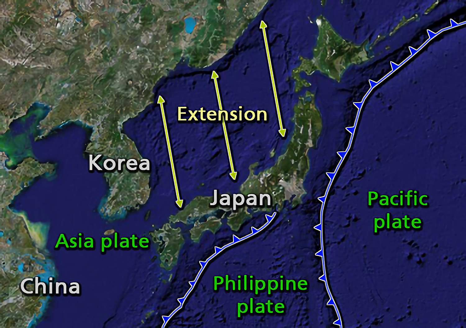
The islands of Japan are primarily the result of several large ocean movements occurring over hundreds of millions of years from the mid- Silurian to the Pleistocene, as a result of the subduction of the Philippine Sea Plate beneath the continental Amurian Plate and Okinawa Plate to the south, and subduction of the Pacific Plate under the Okhotsk Plate to the north. Japan was originally attached to the eastern coast of the Eurasian continent. The subducting plates, being deeper than the Eurasian plate, pulled Japan eastward, opening the Sea of Japan around 15 million years ago. The Strait of Tartary and the Korea Strait opened much later. Japan is situated in a volcanic zone on the Pacific Ring of Fire. Frequent low intensity earth tremors and occasional volcanic activity are felt throughout the islands. Destructive earthquakes, often resulting in tsunamis, occur several times per century. The most recent major quakes include the 2011 Tōhoku earthquake and tsunami, the 2004 ... [...More Info...] [...Related Items...] OR: [Wikipedia] [Google] [Baidu] |
Geology Of Indonesia
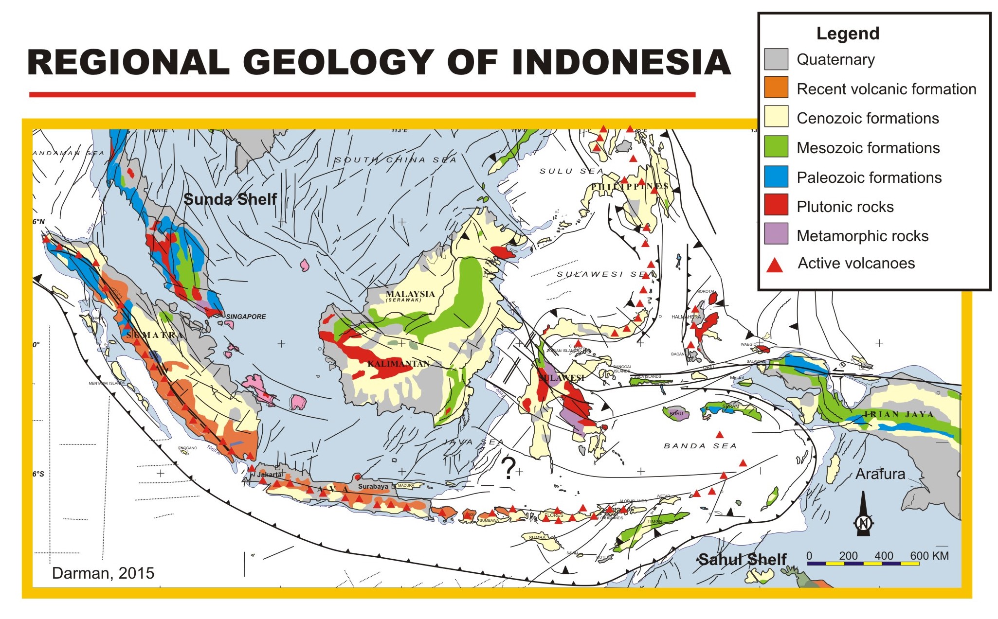
This is a brief summary of the geology of Indonesia. Indonesia is located between two major tectonic plates, the Australian Plate and the Eurasian Plate. Tectonics The tectonics of Indonesia are very complex, as it is a meeting point of several tectonic plates. Indonesia is located between two continental plates: the Australian Plate (Sahul Shelf) and the Eurasian Plate (Sunda Shelf); and between two oceanic plates: the Pacific Plate and the Philippine Sea Plate. The subduction of the Indian Plate beneath the Eurasian Plate formed the volcanic arc in western Indonesia, one of the most seismically active areas on the planet with a long history of powerful eruptions and earthquakes. This chain of active volcanoes formed Sumatra, Java, Bali, and the Lesser Sunda Islands, most of which, particularly Java and Bali, emerged within the last 2–3 million years. The Pacific and Australian plate movements controlled the tectonics of the eastern portion of Indonesia. Structural g ... [...More Info...] [...Related Items...] OR: [Wikipedia] [Google] [Baidu] |
Sikkim
Sikkim (; ) is a state in Northeastern India. It borders the Tibet Autonomous Region of China in the north and northeast, Bhutan in the east, Province No. 1 of Nepal in the west and West Bengal in the south. Sikkim is also close to the Siliguri Corridor, which borders Bangladesh. Sikkim is the least populous and second smallest among the Indian states. Situated in the Eastern Himalaya, Sikkim is notable for its biodiversity, including alpine and subtropical climates, as well as being a host to Kangchenjunga, the highest peak in India and third highest on Earth. Sikkim's capital and largest city is Gangtok. Almost 35% of the state is covered by Khangchendzonga National Park – a UNESCO World Heritage Site. The Kingdom of Sikkim was founded by the Namgyal dynasty in the 17th century. It was ruled by Buddhist priest-kings known as the Chogyal. It became a princely state of British India in 1890. Following Indian independence, Sikkim continued its protectorate status with ... [...More Info...] [...Related Items...] OR: [Wikipedia] [Google] [Baidu] |
Geology Of India
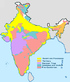
The geology of India is diverse. Different regions of India contain rocks belonging to different geologic periods, dating as far back as the Eoarchean Era. Some of the rocks are very deformed and altered. Other deposits include recently deposited alluvium that has yet to undergo diagenesis. Mineral deposits of great variety are found in the Indian subcontinent in huge quantities. Even India's fossil record is impressive in which stromatolites, invertebrates, vertebrates and plant fossils are included. India's geographical land area can be classified into the Deccan Traps, Gondwana and Vindhyan. The Deccan Traps covers almost all of Maharashtra, a part of Gujarat, Karnataka, Madhya Pradesh and Andhra Pradesh marginally. During its journey northward after breaking off from the rest of Gondwana, the Indian Plate passed over a geologic hotspot, the Réunion hotspot, which caused extensive melting underneath the Indian Craton. The melting broke through the surface of the crato ... [...More Info...] [...Related Items...] OR: [Wikipedia] [Google] [Baidu] |
Geology Of Hong Kong
The geology of Hong Kong is dominated by igneous rocks (including granitic rocks and volcanic rocks) formed during a major volcanic eruption period in the Mesozoic era. It made up 85% of Hong Kong's land surface and the remaining 15% are mostly sedimentary rocks located in the northeast New Territories. There are also a very small percentage (less than 1%) of metamorphic rocks in New Territories. These are formed by deformation of pre-existing sedimentary rocks which changed its mineral assemblages (metamorphism). The geological history of Hong Kong started as early as the Devonian period (~420 million years ago) which is marked by the discovery of Placoderm (a Devonian fish) fossils in northeast Hong Kong. While the youngest rocks in Hong Kong are formed during the Paleogene period(~50 million years old). They are today exposed in Tung Ping Chau in northeast Hong Kong. Each of the three types of rocks: igneous, sedimentary, and metamorphic rocks formed spectacular geological fe ... [...More Info...] [...Related Items...] OR: [Wikipedia] [Google] [Baidu] |


