|
Royal Highland Fusiliers
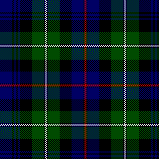
The Royal Highland Fusiliers, 2nd Battalion, The Royal Regiment of Scotland (2 SCOTS) is an infantry battalion of the Royal Regiment of Scotland. Prior to 28 March 2006, the Royal Highland Fusiliers was an infantry regiment in its own right, created by the amalgamation of the Royal Scots Fusiliers with the Highland Light Infantry (City of Glasgow Regiment) in January 1959. History The regiment was formed as the Royal Highland Fusiliers (Princess Margaret's Own Glasgow and Ayrshire Regiment) on 20 January 1959 by the amalgamation of the Royal Scots Fusiliers with the Highland Light Infantry (City of Glasgow Regiment). The Royal Highland Fusiliers, abbreviated as 'The RHF', were part of the Scottish Division. The regiment was initially based at Redford Barracks in Edinburgh before being deployed to Singapore Lines in Aden in 1960. The regimental band played at independence ceremonies in Hargeisa in 1960. It was then posted to St. Patricks barracks in Malta in 1961, to Mons B ... [...More Info...] [...Related Items...] OR: [Wikipedia] [Google] [Baidu] |
Infantry
Infantry is a military specialization which engages in ground combat on foot. Infantry generally consists of light infantry, mountain infantry, motorized infantry & mechanized infantry, airborne infantry, air assault infantry, and marine infantry. Although disused in modern times, heavy infantry also commonly made up the bulk of many historic armies. Infantry, cavalry, and artillery have traditionally made up the core of the combat arms professions of various armies, with the infantry almost always comprising the largest portion of these forces. Etymology and terminology In English, use of the term ''infantry'' began about the 1570s, describing soldiers who march and fight on foot. The word derives from Middle French ''infanterie'', from older Italian (also Spanish) ''infanteria'' (foot soldiers too inexperienced for cavalry), from Latin '' īnfāns'' (without speech, newborn, foolish), from which English also gets '' infant''. The individual-soldier term ''infantry ... [...More Info...] [...Related Items...] OR: [Wikipedia] [Google] [Baidu] |
Aden
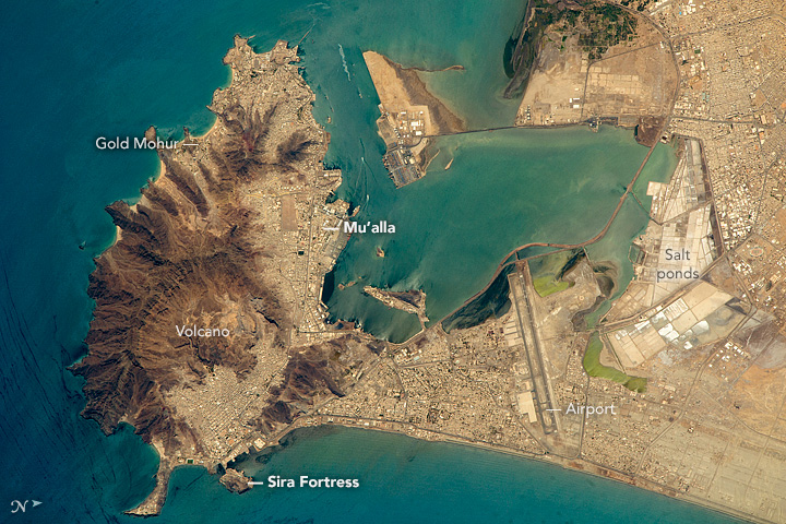
Aden ( ar, عدن ' Yemeni: ) is a city, and since 2015, the temporary capital of Yemen, near the eastern approach to the Red Sea (the Gulf of Aden), some east of the strait Bab-el-Mandeb. Its population is approximately 800,000 people. Aden's natural harbour lies in the crater of a dormant volcano, which now forms a peninsula joined to the mainland by a low isthmus. This harbour, Front Bay, was first used by the ancient Kingdom of Awsan between the 7th to 5th centuries BC. The modern harbour is on the other side of the peninsula. Aden gets its name from the Gulf of Aden. Aden consists of a number of distinct sub-centres: Crater, the original port city; Ma'alla, the modern port; Tawahi, known as "Steamer Point" in the colonial period; and the resorts of Gold Mohur. Khormaksar, on the isthmus that connects Aden proper with the mainland, includes the city's diplomatic missions, the main offices of Aden University, and Aden International Airport (the former British Roy ... [...More Info...] [...Related Items...] OR: [Wikipedia] [Google] [Baidu] |
Berlin
Berlin ( , ) is the capital and largest city of Germany by both area and population. Its 3.7 million inhabitants make it the European Union's most populous city, according to population within city limits. One of Germany's sixteen constituent states, Berlin is surrounded by the State of Brandenburg and contiguous with Potsdam, Brandenburg's capital. Berlin's urban area, which has a population of around 4.5 million, is the second most populous urban area in Germany after the Ruhr. The Berlin-Brandenburg capital region has around 6.2 million inhabitants and is Germany's third-largest metropolitan region after the Rhine-Ruhr and Rhine-Main regions. Berlin straddles the banks of the Spree, which flows into the Havel (a tributary of the Elbe) in the western borough of Spandau. Among the city's main topographical features are the many lakes in the western and southeastern boroughs formed by the Spree, Havel and Dahme, the largest of which is Lake Müggelsee. Due to its l ... [...More Info...] [...Related Items...] OR: [Wikipedia] [Google] [Baidu] |
Holywood, County Down
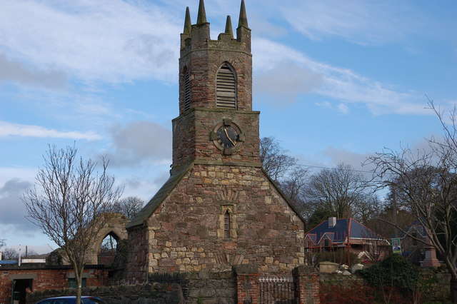
Holywood ( ) (Irish: ''Ard Mhic Nasca'', meaning 'Height of the Son of Nasca'. Latin: ''Sanctus Boscus'', meaning 'Holy Wood') is a town in the metropolitan area of Belfast in County Down, Northern Ireland. It is a civil parish and townland of 755 acres lying on the shore of Belfast Lough, between Belfast and Bangor. Holywood Exchange and Belfast City Airport are nearby. The town hosts an annual jazz and blues festival. Toponymy The English name ''Holywood'' comes . This was the name the Normans gave to the woodland surrounding the monastery of St Laiseran, son of Nasca. The monastery was founded by Laiseran before 640 and was on the site of the present Holywood Priory. The earliest Anglicised form appears as ''Haliwode'' in a 14th-century document. The Irish name for Holywood is ''Ard Mhic Nasca'' meaning "high ground of Mac Nasca". History In the early 19th century, Holywood, like many other coastal villages throughout Ireland, became popular as a resort for sea-bathing. M ... [...More Info...] [...Related Items...] OR: [Wikipedia] [Google] [Baidu] |
Palace Barracks
Palace Barracks, Holywood is a British Army installation in Holywood, County Down, Northern Ireland. History Palace Barracks occupies the site of a palatial house known as "Ardtullagh", the home of the Bishop of Down, Connor and Dromore until it was bought by the UK War Office in 1886. In 1933, six children of Lance Corporal Harry Poole and his wife, Mary, lost their lives from asphyxiation following gas poisoning in the married quarters of the barracks. During the roughly three decades of "The Troubles" in Northern Ireland, the barracks served as the home base for battalions rotating through the province, especially those on a two-year "accompanied" tour with their families. A wide variety of facilities are available for soldiers to use off duty, including a swimming pool, squash courts, saunas, bars and a gymnasium. Palace Barracks became the Regimental Headquarters of the Royal Irish Regiment in 2008. In March 2010, it was the site of a bombing. An elderly man was blown off ... [...More Info...] [...Related Items...] OR: [Wikipedia] [Google] [Baidu] |
Hemer
Hemer is a town in the Märkischer Kreis district, in North Rhine-Westphalia, Germany. Geography Hemer is located at the north end of the Sauerland near the Ruhr (river), Ruhr river. The highest elevation, at 546 metres (1,791 ft), is in the ''Balver Wald'' in the south of the city. The lowest elevation, at 160 metres (525 ft), is at the ''Edelburg'' in the northeast. History Tumulus, Burial mounds show that around 1250 BC, Bronze Age shepherds and farmers lived in the area. Graves from the time of the Merovingian Franks around the year 650 were found near the present city centre. Hemer was first mentioned in 1072 by its old name ''Hademare'' in a document of bishop Archbishop Anno II, Anno II of Archbishopric of Cologne, Cologne, granting lands to the newly founded Benedictine Grafschaft Abbey, including St. Vitus's church and two farms, the later '':de:Haus Hemer'' and the '':de:Hedhof''. In 1124 the parish of St. Vitus was separated from the parish of Menden. Hem ... [...More Info...] [...Related Items...] OR: [Wikipedia] [Google] [Baidu] |
Bulford Camp
Bulford Camp is a military camp on Salisbury Plain in Wiltshire, England. Established in 1897, the site continues in use as a large British Army base. The camp is close to the village of Bulford and is about northeast of the town of Amesbury. The camp forms part of the Tidworth, Netheravon and Bulford (TidNBul) Garrison. History The camp was built as a mixture of tents and huts in 1897. The section called Sling Camp was occupied by soldiers of the New Zealand Expeditionary Force during the First World War. At the end of the war, the overcrowded camp was the site of the Battle of Bulford, when New Zealand troops staged a brief mutiny. Later, New Zealanders awaiting demobilization left their mark by creating the Bulford Kiwi, a large chalk figure on the hillside overlooking the camp. Permanent barracks were built during the inter-war years: the current names were applied in 1931. Carter Barracks, a hutted camp north of Bulford Droveway, beyond the northern boundary of the present ... [...More Info...] [...Related Items...] OR: [Wikipedia] [Google] [Baidu] |
The Troubles
The Troubles ( ga, Na Trioblóidí) were an ethno-nationalist conflict in Northern Ireland that lasted about 30 years from the late 1960s to 1998. Also known internationally as the Northern Ireland conflict, it is sometimes described as an "irregular war" or "Low-intensity conflict, low-level war". The conflict began in the late 1960s and is usually deemed to have ended with the Good Friday Agreement of 1998. Although the Troubles mostly took place in Northern Ireland, at times violence spilled over into parts of the Republic of Ireland, England and mainland Europe. The conflict was primarily political and nationalistic, fuelled by historical events. It also had an Ethnic group, ethnic or sectarian dimension but despite use of the terms 'Protestant' and 'Catholic' to refer to the two sides, it was not a Religious war, religious conflict. A key issue was the Partition of Ireland, status of Northern Ireland. Unionism in Ireland, Unionists and Ulster loyalism, loyalists, who for ... [...More Info...] [...Related Items...] OR: [Wikipedia] [Google] [Baidu] |
Northern Ireland
Northern Ireland ( ga, Tuaisceart Éireann ; sco, label= Ulster-Scots, Norlin Airlann) is a part of the United Kingdom, situated in the north-east of the island of Ireland, that is variously described as a country, province or region. Northern Ireland shares an open border to the south and west with the Republic of Ireland. In 2021, its population was 1,903,100, making up about 27% of Ireland's population and about 3% of the UK's population. The Northern Ireland Assembly (colloquially referred to as Stormont after its location), established by the Northern Ireland Act 1998, holds responsibility for a range of devolved policy matters, while other areas are reserved for the UK Government. Northern Ireland cooperates with the Republic of Ireland in several areas. Northern Ireland was created in May 1921, when Ireland was partitioned by the Government of Ireland Act 1920, creating a devolved government for the six northeastern counties. As was intended, Northern Ireland ... [...More Info...] [...Related Items...] OR: [Wikipedia] [Google] [Baidu] |
Francisco Franco
Francisco Franco Bahamonde (; 4 December 1892 – 20 November 1975) was a Spanish general who led the Nationalist faction (Spanish Civil War), Nationalist forces in overthrowing the Second Spanish Republic during the Spanish Civil War and thereafter ruled over Spanish State, Spain from 1939 to 1975 as a dictator, assuming the title ''Caudillo''. This period in Spanish history, from the Nationalist victory to Franco's death, is commonly known as Francoist Spain or as the Francoist dictatorship. Born in Ferrol, Spain, Ferrol, Galicia (Spain), Galicia, into an upper-class military family, Franco served in the Spanish Army as a cadet in the Toledo Infantry Academy from 1907 to 1910. While serving in Spanish protectorate in Morocco, Morocco, he rose through the ranks to become a brigadier general in 1926 at age 33, which made him the #Military career, youngest general in all of Europe. Two years later, Franco became the director of the General Military Academy in Zaragoza. A ... [...More Info...] [...Related Items...] OR: [Wikipedia] [Google] [Baidu] |
Gibraltar
) , anthem = " God Save the King" , song = " Gibraltar Anthem" , image_map = Gibraltar location in Europe.svg , map_alt = Location of Gibraltar in Europe , map_caption = United Kingdom shown in pale green , mapsize = , image_map2 = Gibraltar map-en-edit2.svg , map_alt2 = Map of Gibraltar , map_caption2 = Map of Gibraltar , mapsize2 = , subdivision_type = Sovereign state , subdivision_name = , established_title = British capture , established_date = 4 August 1704 , established_title2 = , established_date2 = 11 April 1713 , established_title3 = National Day , established_date3 = 10 September 1967 , established_title4 = Accession to EEC , established_date4 = 1 January 1973 , established_title5 = Withdrawal from the EU , established_date5 = 31 January 2020 , official_languages = English , languages_type = Spoken languages , languages = , capital = Westside, Gibraltar (de facto) , coordinates = , largest_settlement_type = largest district , l ... [...More Info...] [...Related Items...] OR: [Wikipedia] [Google] [Baidu] |
Fort George, Scotland
Fort George is a large 18th-century fortress near Ardersier, to the north-east of Inverness in the Highland council area of Scotland. It was built to control the Scottish Highlands in the aftermath of the Jacobite rising of 1745, replacing a ''Fort George'' in Inverness constructed after the 1715 Jacobite rising to control the area. The current fortress has never been attacked and has remained in continuous use as a garrison. The fortification is based on a star design; it remains virtually unaltered and nowadays is open to visitors with exhibits and facsimiles showing the fort's use at different periods, while still serving as an army barracks. First Fort George The first Fort George was built in 1727 in Inverness; it was a large fortress capable of housing 400 troops on a hill beside the River Ness, on the site of (and incorporating portions of) the medieval castle that had been rebuilt as a citadel by Oliver Cromwell but later abandoned. The first commanding officer of ... [...More Info...] [...Related Items...] OR: [Wikipedia] [Google] [Baidu] |


