|
Rodino (rural Locality)
Rodino (russian: Родино) is the name of several types of inhabited localities in Russia, rural localities in Russia: *Rodino, Rodinsky District, Altai Krai, a ''village#Russia, selo'' in Rodinsky Selsoviet of Rodinsky District of Altai Krai *Rodino, Shipunovsky District, Altai Krai, a ''selo'' in Rodinsky Selsoviet of Shipunovsky District of Altai Krai *Rodino, Ivanovo Oblast, a village#Russia, village in Pestyakovsky District of Ivanovo Oblast *Rodino, Kirov Oblast, a village in Loshkarinsky Rural Okrug of Sovetsky District, Kirov Oblast, Sovetsky District of Kirov Oblast *Rodino, Mezhevskoy District, Kostroma Oblast, a village in Nikolskoye Settlement of Mezhevskoy District of Kostroma Oblast *Rodino, Parfenyevsky District, Kostroma Oblast, a village in Matveyevskoye Settlement of Parfenyevsky District of Kostroma Oblast *Rodino, Smolensk Oblast, a village in Vysokovskoye Rural Settlement of Novoduginsky District of Smolensk Oblast *Rodino, Tver Oblast, a village in Privolzh ... [...More Info...] [...Related Items...] OR: [Wikipedia] [Google] [Baidu] |
Types Of Inhabited Localities In Russia
The classification system of inhabited localities in Russia and some other post-Soviet states has certain peculiarities compared with those in other countries. Classes During the Soviet time, each of the republics of the Soviet Union, including the Russian SFSR, had its own legislative documents dealing with classification of inhabited localities. After the dissolution of the Soviet Union, the task of developing and maintaining such classification in Russia was delegated to the federal subjects.Articles 71 and 72 of the Constitution of Russia do not name issues of the administrative and territorial structure among the tasks handled on the federal level or jointly with the governments of the federal subjects. As such, all federal subjects pass their own laws establishing the system of the administrative-territorial divisions on their territories. While currently there are certain peculiarities to classifications used in many federal subjects, they are all still largely ba ... [...More Info...] [...Related Items...] OR: [Wikipedia] [Google] [Baidu] |
Mezhevskoy District
Mezhevskoy District (russian: Межевско́й райо́н) is an administrativeLaw #112-4-ZKO and municipalLaw #237-ZKO district (raion), one of the administrative divisions of Kostroma Oblast, twenty-four in Kostroma Oblast, Russia. It is located in the north of the oblast. The area of the district is . Its administrative center is the types of inhabited localities in Russia, rural locality (a ''village#Russia, selo'') of Georgiyevskoye, Mezhevskoy District, Kostroma Oblast, Georgiyevskoye. Population: 5,851 (Russian Census (2002), 2002 Census); The population of Georgiyevskoye accounts for 56.3% of the district's total population. References Notes Sources * * * * * {{Use mdy dates, date=May 2014 Districts of Kostroma Oblast ... [...More Info...] [...Related Items...] OR: [Wikipedia] [Google] [Baidu] |
Kirillovsky District
Kirillovsky District (russian: Кири́лловский райо́н) is an administrativeLaw #371-OZ and municipalLaw #1116-OZ district (raion), one of the twenty-six in Vologda Oblast, Russia. It is located in the north of the oblast and borders with Kargopolsky and Konoshsky Districts of Arkhangelsk Oblast in the north, Vozhegodsky and Ust-Kubinsky Districts in the east, Vologodsky District in the southeast, Sheksninsky District in the south, Cherepovetsky District in the southeast, Belozersky and Vashkinsky Districts in the west, and with Vytegorsky District in the northwest. The area of the district is . Its administrative center is the town of Kirillov.Resolution #178 Population: 18,627 ( 2002 Census); The population of Kirillov accounts for 48.7% of the district's total population. Geography The area of the district is elongated from north to south and is split into two roughly equal parts by the divide between the basins of the Arctic Ocean and the Caspian Se ... [...More Info...] [...Related Items...] OR: [Wikipedia] [Google] [Baidu] |
Tver Oblast
Tver Oblast (russian: Тверска́я о́бласть, ''Tverskaya oblast'', ), from 1935 to 1990 known as Kalinin Oblast (), is a federal subject of Russia (an oblast). Its administrative center is the city of Tver. It was named after Mikhail Kalinin, the Soviet revolutionary. Population: 1,353,392 ( 2010 Census). Tver Oblast is a region of lakes, such as Seliger and Brosno. Much of the remaining area is occupied by the Valdai Hills, where the Volga, the Western Dvina, and the Dnieper have their source. Tver Oblast is one of the tourist regions of Russia with a modern tourist infrastructure. There are also many historic towns: Torzhok, Toropets, Zubtsov, Kashin, Vyshny Volochyok, and Kalyazin. The oldest of these is Rzhev, primarily known for the Battles of Rzhev in World War II. Staritsa was the seat of the last appanage principality in Russia. Ostashkov is a major tourist center. Geography Tver Oblast is located in the west of the middle part of the East European Plai ... [...More Info...] [...Related Items...] OR: [Wikipedia] [Google] [Baidu] |
Kimrsky District
Kimrsky District (russian: Ки́мрский райо́н) is an administrative and municipalLaw #4-ZO district (raion), one of the thirty-six in Tver Oblast, Russia. It is located in the southeast of the oblast and borders with Kalyazinsky District in the northeast, Taldomsky District of Moscow Oblast and the town of Dubna, also of Moscow Oblast, in the south, Konakovsky District in the southwest, Kalininsky District in the west, and with Rameshkovsky District in the northwest. The area of the district is . Its administrative center is the town of Kimry (which is not administratively a part of the district).Law #34-ZO Population: 13,190 ( 2010 Census); Geography The whole area of the district belongs to the drainage basin of the Volga. The Volga, built as the Uglich Reservoir, crosses the district from the southwest to the northeast, separating it into two unequal parts. The rivers in the northern, bigger part of the district drains into the Volga directly or to the Medvedits ... [...More Info...] [...Related Items...] OR: [Wikipedia] [Google] [Baidu] |
Smolensk Oblast
Smolensk Oblast (russian: Смоле́нская о́бласть, ''Smolenskaya oblast''; informal name — ''Smolenschina'' (russian: Смоле́нщина)) is a federal subject of Russia (an oblast). Its administrative centre is the city of Smolensk. As of the 2010 Census, its population was 985,537. Geography The oblast was founded on 27 September 1937.Исполнительный комитет Смоленского областного совета народных депутатов. Государственный архив Смоленской области. "Административно-территориальное устройство Смоленской области. Справочник", изд. "Московский рабочий", Москва 1981. Стр. 8 It borders Pskov Oblast in the north, Tver Oblast in the northeast, Moscow Oblast in the east, Kaluga Oblast in south, Bryansk Oblast in the southwest, and Mogilev and Vitebsk Oblast ... [...More Info...] [...Related Items...] OR: [Wikipedia] [Google] [Baidu] |
Novoduginsky District
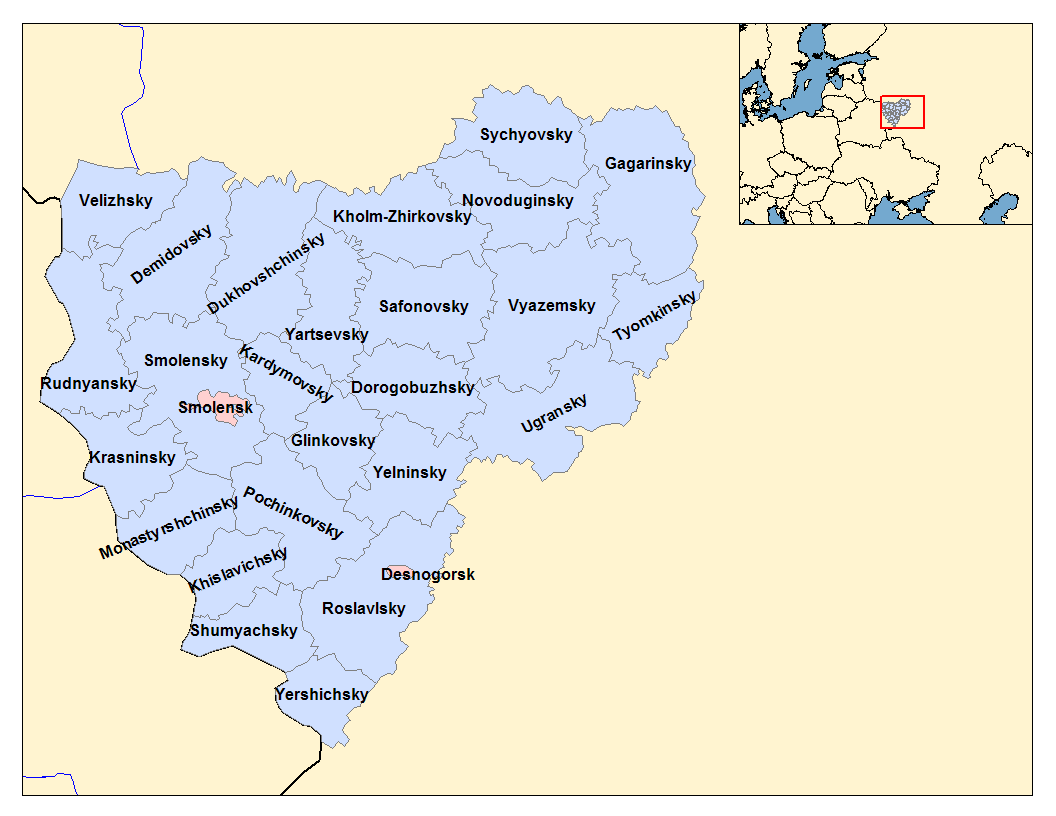
Novoduginsky District (russian: Новодугинский райо́н) is an administrativeResolution #261 and municipalLaw #109-z district (raion), one of the twenty-five in Smolensk Oblast, Russia. It is located in the northeast of the oblast. The area of the district is . Its administrative center is the rural locality In general, a rural area or a countryside is a geographic area that is located outside towns and cities. Typical rural areas have a low population density and small settlements. Agricultural areas and areas with forestry typically are describ ... (a '' selo'') of Novodugino. Population: 10,477 ( 2010 Census); The population of Novodugino accounts for 36.6% of the district's total population. References Notes Sources * * {{Use mdy dates, date=January 2013 Districts of Smolensk Oblast ... [...More Info...] [...Related Items...] OR: [Wikipedia] [Google] [Baidu] |
Parfenyevsky District
Parfenyevsky District (russian: Парфе́ньевский райо́н) is an administrativeLaw #112-4-ZKO and municipalLaw #237-ZKO district (raion), one of the twenty-four in Kostroma Oblast, Russia. It is located in the center of the oblast. The area of the district is . Its administrative center is the rural locality (a '' selo'') of Parfenyevo. Population: 7,857 ( 2002 Census); The population of Parfenyevo accounts for 44.9% of the district's total population. Geography Parfenyevsky District is located in the center of Kostroma Oblast. The terrain is flat or slightly hilly, with pine-larch forests (southern taiga) covering 84% of the district, including some old-growth stands of cedars and oak. Pleistocene glaciation left a landscape of alluvial outwash, moraines, swamps, and lakes. The upper courses of the Neya River are in the district. Parfenyevsky District is 150 km northeast of the regional city of Kostroma, and about 480 km northeast of Moscow. The ... [...More Info...] [...Related Items...] OR: [Wikipedia] [Google] [Baidu] |


